이 페이지는 앱이나 개발자의 공식 페이지가 아니며, 정보 제공 및 논평을 목적으로 작성된 독립 편집 간행물입니다. 명시적으로 달리 언급되지 않는 한, 해당 앱이나 개발자는 MWM, Apple, Google Play, 앱 퍼블리셔 또는 앱 개발자와 제휴, 보증, 후원, 승인 또는 공식적으로 연결되어 있지 않으며, 이 페이지의 어떤 내용도 해당 앱이 MWM의 서비스를 사용하여 개발되었음을 의미하지 않습니다. 모든 상표, 로고, 스크린샷 및 기타 콘텐츠는 해당 소유자의 자산입니다.

Maps 3D PRO - Hike & Bike
170만 명 이상의 모험가들이 오프라인 NASA급 지형 지도와 전문 GPS 추적 기능을 사용하여 모든 봉우리와 트레일을 정복하고 있습니다.
다운로드
378K+사용자 평점
총 평가 수
100개발사
카테고리
Navigation지원 언어
6최신 버전
6.8크기
25.2 MB출시일
2011년 3월 25일모든 지형을 놀라운 3D로 정복하세요
평면 지도로 길을 찾지 마세요. 진정한 탐험가를 위해 설계된 전문적인 3D 고도 및 오프라인 GPS 추적 기능으로 다음 모험을 조감하세요.
정밀 3D 시각화
NASA 지형 스캔을 사용하여 계곡, 언덕, 봉우리를 시각화하세요. 출발 전에 경로의 정확한 고도와 난이도를 파악할 수 있습니다.
완벽한 오프라인 안정성
출발 전에 전 세계 지도 데이터를 다운로드하세요. 완벽한 GPS 기능과 셀 신호 없이도 깊은 오지에서 안전하게 길을 찾으세요.
다음 스크린샷과 설명은 앱의 공식 스토어 목록에서 직접 가져온 것이며 앱 개발자의 자산입니다.
앱 스토어
스크린샷
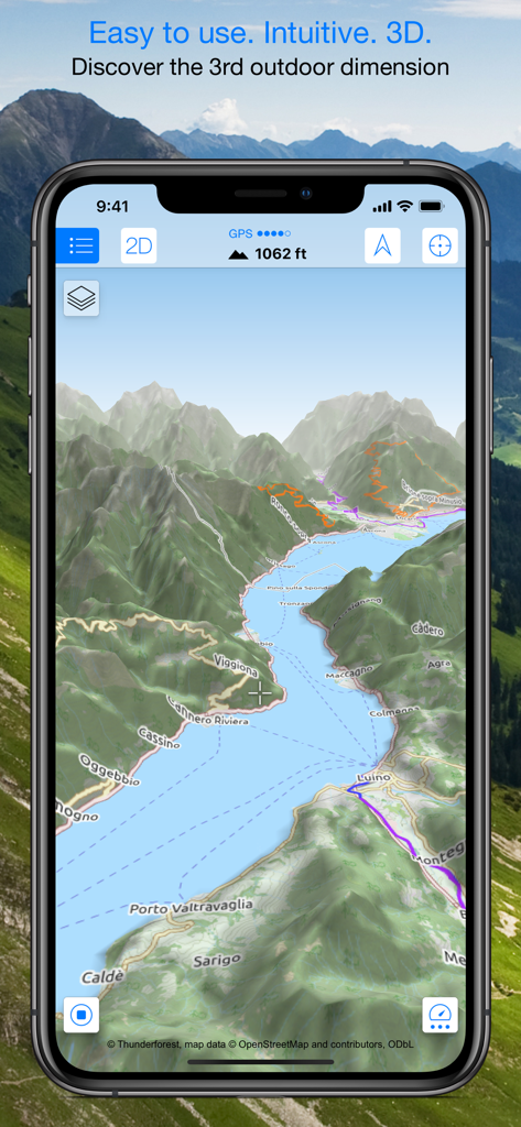
산과 하이킹 트레일이 있는 3D 지형 지도를 표시하는 스마트폰.
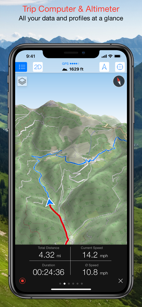
속도, 거리, 고도를 포함한 여행 컴퓨터 데이터가 표시된 3D 지형 지도를 보여주는 Maps 3D PRO 인터페이스
하이킹 트레일과 고도 프로필이 있는 3D 지형 지도를 표시하는 Maps 3D PRO 앱 인터페이스
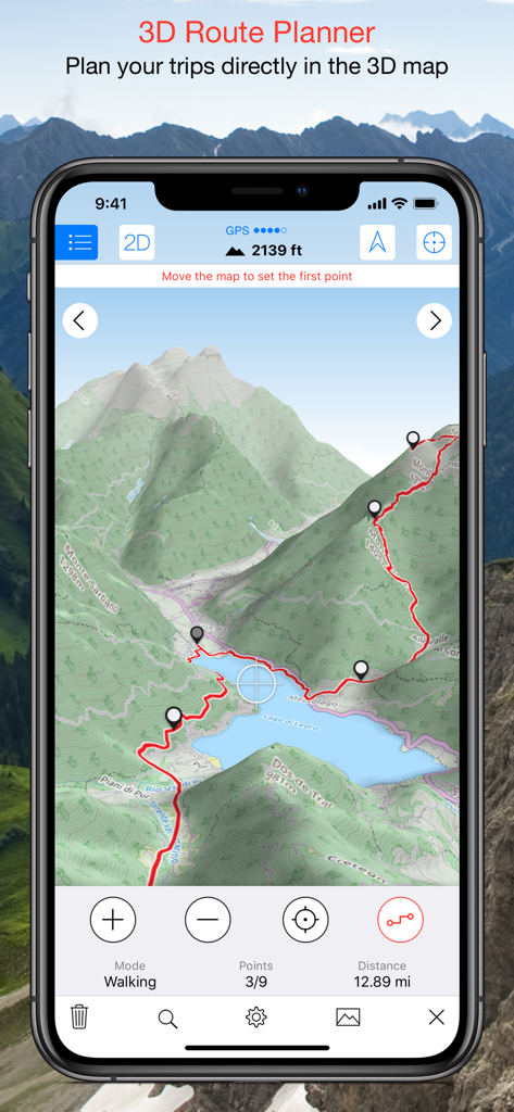
3D 지형 지도에 계획된 하이킹 경로를 보여주는 Maps 3D PRO 앱 스크린샷
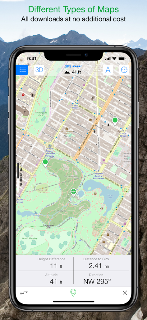
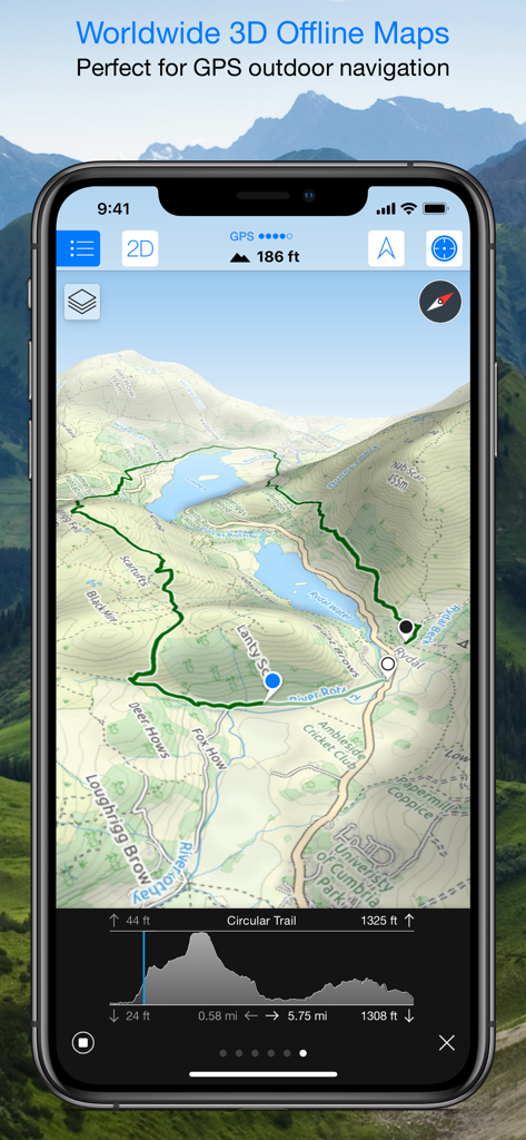
실시간 고도 및 거리 추적 데이터가 포함된 상세한 공원 지도를 표시하는 Maps 3D PRO 앱 인터페이스
설명
Download
비슷한 앱
유사한 기능과 사용자 경험을 가진 앱

AllTrails: Hike, Bike & Run
AllTrails, Inc.

Pedometer++
Cross Forward Consulting, LLC

Organic Maps: Offline Map
Organic Maps OU

Gaia GPS: Mobile Trail Maps
Trailbehind, INC.

Offline hiking maps: Mapy.com
Seznam.cz a.s.

Hiking Map Poland
Mapa Turystyczna sp. z o.o.

MapOut
Valnova GmbH

FarOut: Offline GPS Trail Maps
Atlas Guides DE, Inc.

Norgeskart
Norgeskart AS
이 페이지는 앱이나 개발자의 공식 페이지가 아니며, 정보 제공 및 논평을 목적으로 작성된 독립 편집 간행물입니다. 명시적으로 달리 언급되지 않는 한, 해당 앱이나 개발자는 MWM, Apple, Google Play, 앱 퍼블리셔 또는 앱 개발자와 제휴, 보증, 후원, 승인 또는 공식적으로 연결되어 있지 않으며, 이 페이지의 어떤 내용도 해당 앱이 MWM의 서비스를 사용하여 개발되었음을 의미하지 않습니다. 모든 상표, 로고, 스크린샷 및 기타 콘텐츠는 해당 소유자의 자산입니다.