이 페이지는 앱이나 개발자의 공식 페이지가 아니며, 정보 제공 및 논평을 목적으로 작성된 독립 편집 간행물입니다. 명시적으로 달리 언급되지 않는 한, 해당 앱이나 개발자는 MWM, Apple, Google Play, 앱 퍼블리셔 또는 앱 개발자와 제휴, 보증, 후원, 승인 또는 공식적으로 연결되어 있지 않으며, 이 페이지의 어떤 내용도 해당 앱이 MWM의 서비스를 사용하여 개발되었음을 의미하지 않습니다. 모든 상표, 로고, 스크린샷 및 기타 콘텐츠는 해당 소유자의 자산입니다.
Memory-Map for All
전문가 등급의 USGS 지형도 및 NOAA 해양 차트로 광야와 파도를 마스터하세요. 진지한 탐험가를 위해 설계된 이 제품은 데스크톱에서 계획하고 세계의 가장 외딴 지역에서 오프라인으로 탐색하기 위한 고정밀 도구입니다.
오프라인 상태에서 절대적인 신뢰성이 필요한 기술 탐험가 및 해양 항해사를 위해 설계되었습니다. 집에서 상세한 경로 계획부터 현장에서의 중요한 내비게이션까지 원활하게 전환하세요.
완전한 오프라인 독립성
'먹통' 지역에서도 자신 있게 탐색하세요. 고해상도 USGS 지형도 및 NOAA 해양 차트를 사전 로드하여 셀룰러 신호 없이도 전체 GPS 기능을 보장합니다.
원활한 크로스 플랫폼 계획
데스크톱 앱을 사용하여 PC 또는 Mac에서 경로를 완벽하게 계획한 다음 클라우드를 통해 모바일 장치로 모든 경유지와 트랙을 자동으로 동기화합니다.
다음 스크린샷과 설명은 앱의 공식 스토어 목록에서 직접 가져온 것이며 앱 개발자의 자산입니다.
앱 스토어
스크린샷
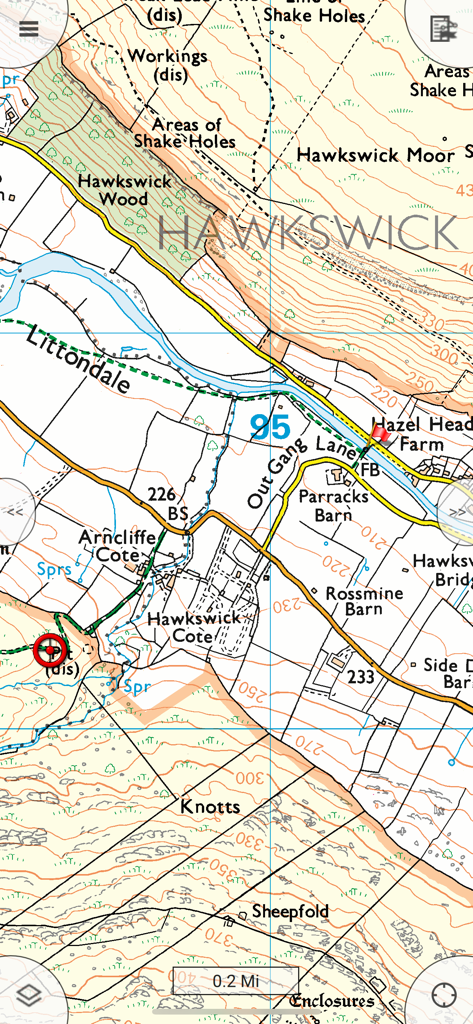
Memory-Map 앱 내 상세 지형도 보기로, 지형 등고선, 건물 및 농촌 내비게이션을 위한 지리적 라벨 표시.
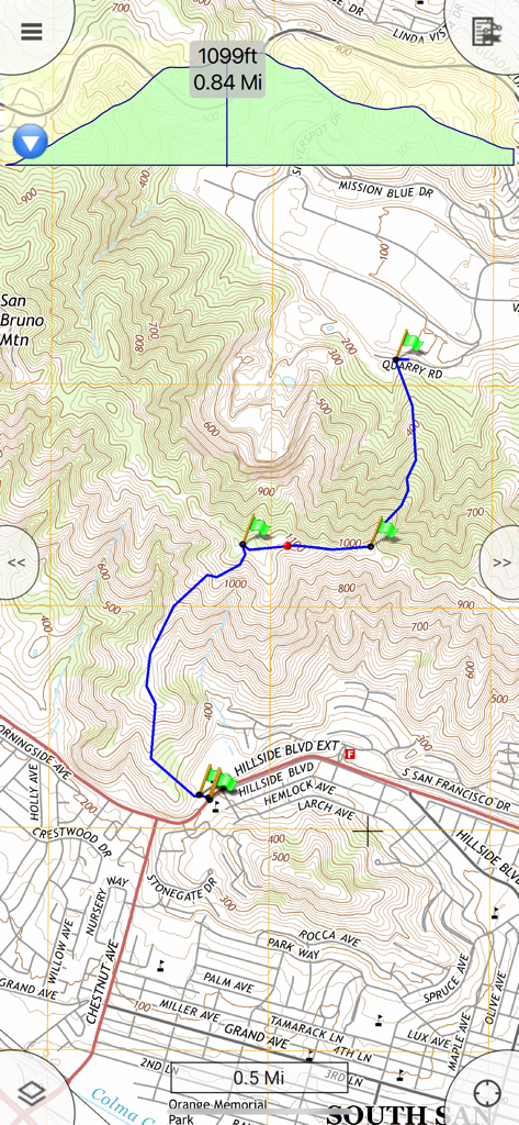
Memory-Map for All 앱의 지형도에 파란색 하이킹 경로, 녹색 경유지 및 상세한 고도 프로필 그래프 표시.
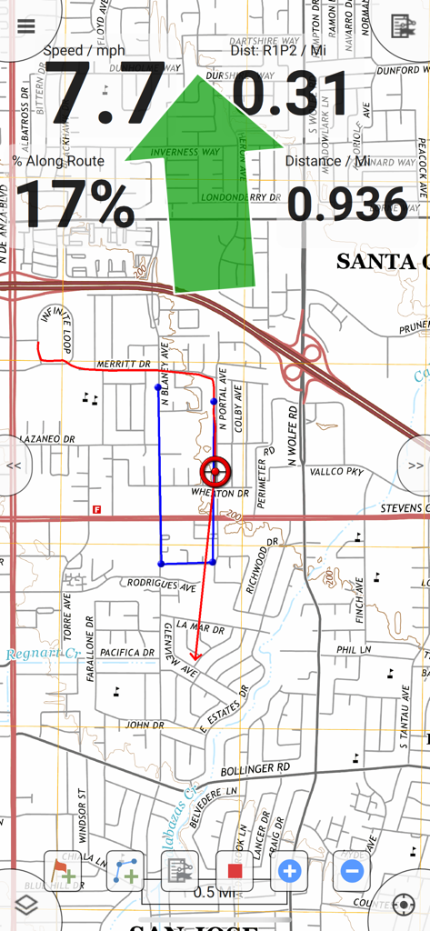
지도 추적과 속도 및 거리 정보가 표시되는 GPS 내비게이션 화면
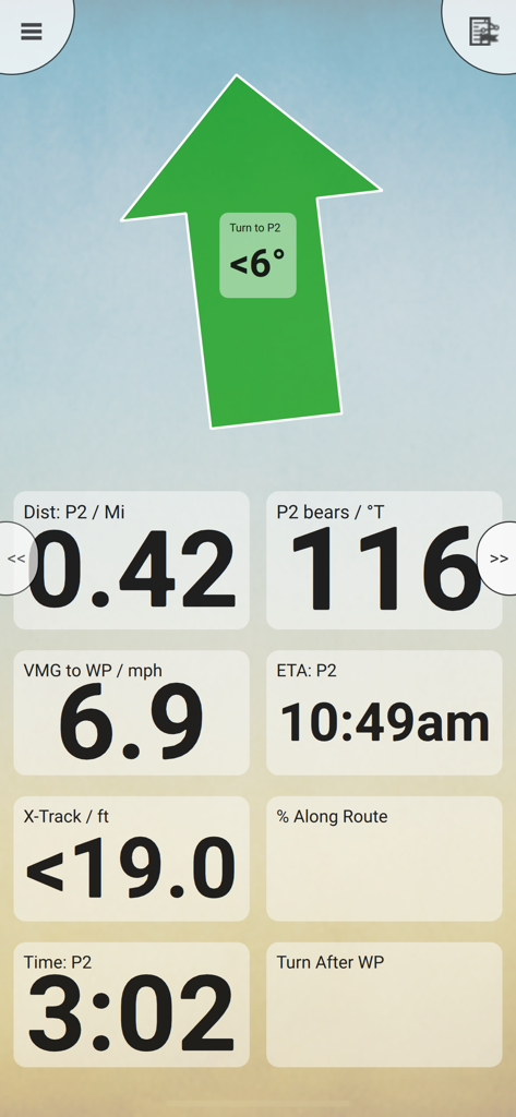
Memory Map 내비게이션 대시보드에 큰 조향 화살표와 거리, 방위각, 예상 도착 시간 데이터 필드 표시
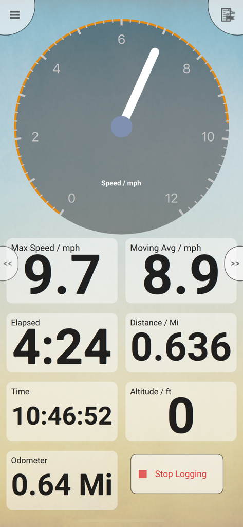
속도계 및 여행 통계를 보여주는 모바일 GPS 내비게이션 대시보드
설명
Download maps for Offline GPS Navigation. No mobile data connection required.
Your favorite maps and charts from OS, Hema, NOAA, and many more.
Immersive 3D World map view
Fully customizable map, data display and toolbar buttons.
Powerful overlay data management, using nested categories and GPX files
Backup and load maps from thumb drive.
Use the same maps and sync your overlay data to other mobile devices and desktop computers
Interactive Route Profile showing terrain elevation
Track Altitude and Speed profile graphs
Show terrain ascent, descent, max elevation and estimated time for planned route
The Memory-Map for All app turns your phone or tablet into a full-featured Outdoor GPS or Marine Chart Plotter, and allows you to navigate with USGS Topo maps, NOAA Marine charts, and many other specialist maps, without needing a mobile internet signal.
Maps are downloaded on-the-fly and can be pre-loaded in bulk, so they are ready to be used offline. Once the app and maps are loaded to the phone or tablet, cellular network coverage or internet connection is not required for real time GPS navigation.
The Memory-Map for All app can be used as a standalone GPS navigator, but it can also be used in conjunction with the Windows PC or Mac app (free download) for planning, printing and loading up maps, waypoints and routes to the phone/tablet.
Memory-Map for All includes free access to 1:250,000 scale topographic maps and many other free maps around the world. More detailed maps are available for download and purchase with a free try-before-you-buy, time-limited demo option. Available maps include Ordnance Survey, Hema, USGS quads, NOAA, UKHO, and DeLorme. Maps can be used on your PC as well as your phone and tablet. The Cloud Sync feature allows you to keep the overlay data consistent on all your devices.
Features include:
Access a vast range of Worldwide maps and charts.
Automatically downloads a free map of your current location
Create and edit marks and routes.
Import and export marks, routes and tracks in the open GPX format
Interactive graphs of terrain elevation, GPS Altitude and Speed profile
Display; Position, Course, Speed, Heading, Altitude and averages
Position coordinates include Lat/Long, UTM, GB Grid, Irish Grid, Military Grid.
Units displayed in Statute, Nautical or Metric, with separate unit setting for Height
Support for GPS and Compass sensors, where available.
Placename search index can be used offline.
Moving map, lock GPS position and automatically scroll the map
Records breadcrumb trail / tracklogs.
Share position marks, routes and tracklogs as GPX files
Full marine instrumentation features, with AIS, DSC and Anchor alarm
NMEA data interface via WiFi for marine instruments
Barometer & relative altitude
Import custom icons for POI
Alarms for mark proximity, Anchor, Geofence or Exclusion zone, Crostrack error
이 페이지는 앱이나 개발자의 공식 페이지가 아니며, 정보 제공 및 논평을 목적으로 작성된 독립 편집 간행물입니다. 명시적으로 달리 언급되지 않는 한, 해당 앱이나 개발자는 MWM, Apple, Google Play, 앱 퍼블리셔 또는 앱 개발자와 제휴, 보증, 후원, 승인 또는 공식적으로 연결되어 있지 않으며, 이 페이지의 어떤 내용도 해당 앱이 MWM의 서비스를 사용하여 개발되었음을 의미하지 않습니다. 모든 상표, 로고, 스크린샷 및 기타 콘텐츠는 해당 소유자의 자산입니다.