이 페이지는 앱이나 개발자의 공식 페이지가 아니며, 정보 제공 및 논평을 목적으로 작성된 독립 편집 간행물입니다. 명시적으로 달리 언급되지 않는 한, 해당 앱이나 개발자는 MWM, Apple, Google Play, 앱 퍼블리셔 또는 앱 개발자와 제휴, 보증, 후원, 승인 또는 공식적으로 연결되어 있지 않으며, 이 페이지의 어떤 내용도 해당 앱이 MWM의 서비스를 사용하여 개발되었음을 의미하지 않습니다. 모든 상표, 로고, 스크린샷 및 기타 콘텐츠는 해당 소유자의 자산입니다.

Norgeskart friluftsliv
전문 탐험가와 오지 모험가를 위해 설계된 공식 정부 등급 UTM 지도, 오프라인 내비게이션 및 중요한 안전 레이어를 통해 지형을 마스터하세요.
다운로드
236K+사용자 평점
총 평가 수
4K+개발사
카테고리
Navigation지원 언어
2최신 버전
1.11.1크기
55.8 MB출시일
2018년 7월 31일전문적인 정밀도로 야생을 마스터하세요
전문가들이 사용하는 것과 동일한 데이터로 노르웨이를 탐색하세요. 오지에서 신뢰성을 요구하는 기술 탐험가를 위해 설계된 노르웨이 매핑 당국의 공식 지도, 고급 안전 레이어 및 고해상도 도구에 액세스하세요.
정부 등급 오프라인 지도
고해상도 UTM 지형도를 다운로드하여 휴대폰 신호가 없는 외딴 피요르드와 험준한 산악 지역에서도 자신감 있게 탐색하세요.
고급 안전 정보
눈사태 경사, 약한 얼음, 눈 깊이 등 전문 레이어를 통해 환경 위험에 대비하세요. 이는 안전한 오지 스키 및 등반에 매우 중요합니다.
다음 스크린샷과 설명은 앱의 공식 스토어 목록에서 직접 가져온 것이며 앱 개발자의 자산입니다.
앱 스토어
스크린샷
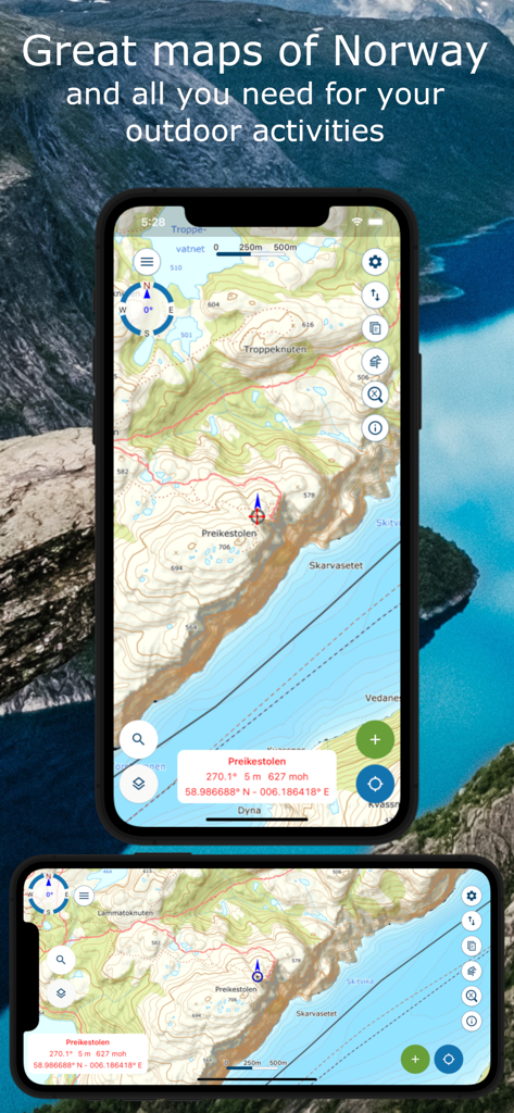
프레이케스톨렌의 상세한 지형도를 보여주는 Norgeskart friluftsliv 앱 인터페이스 (야외 내비게이션용)
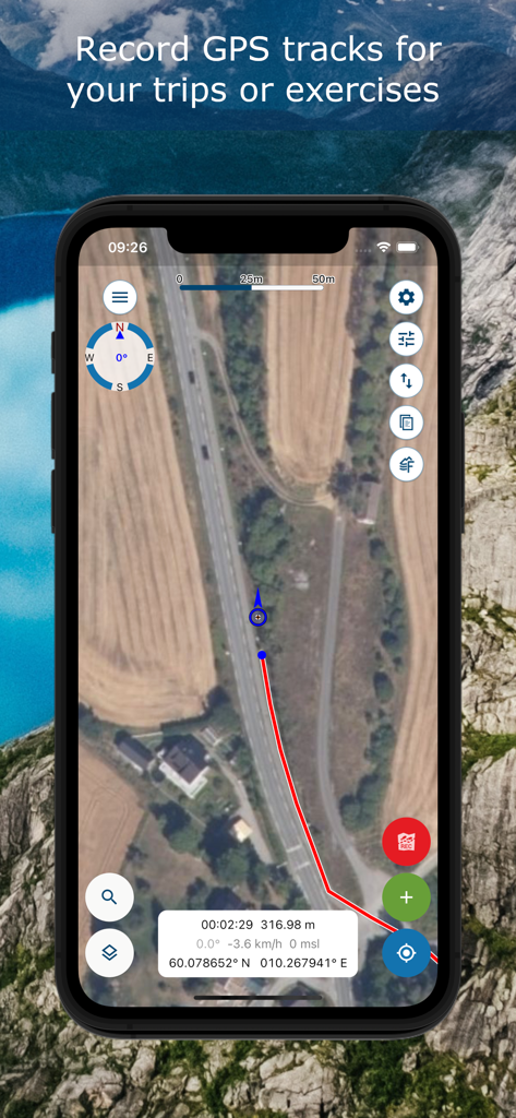
위성 지도에 GPS 트랙 기록을 보여주는 Norgeskart friluftsliv 앱 화면
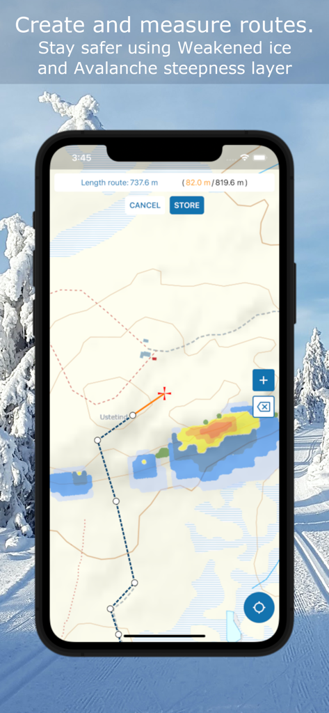
지형도에 경로 측정 및 눈사태 경사 안전 레이어를 보여주는 Norgeskart friluftsliv 인터페이스
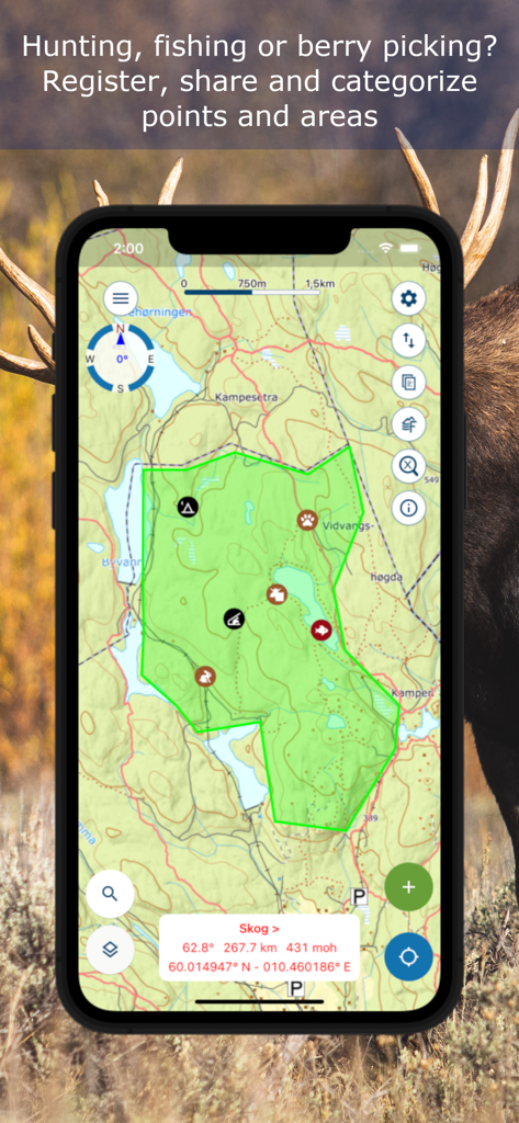
Norgeskart 앱에서 사냥 및 낚시를 위한 맞춤 지점과 구역을 보여주는 지형도.
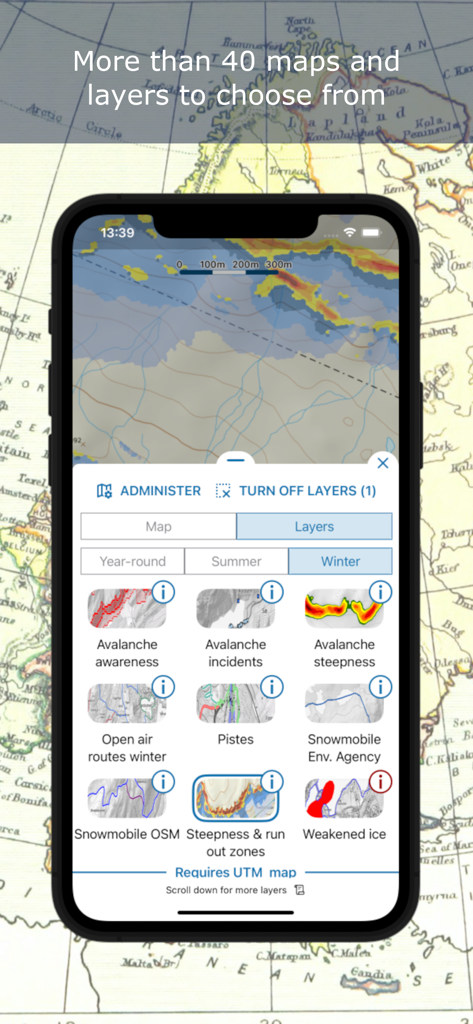
눈사태 인식 및 스키 슬로프와 같은 기술적인 겨울 지도 레이어를 보여주는 Norgeskart friluftsliv 앱 인터페이스
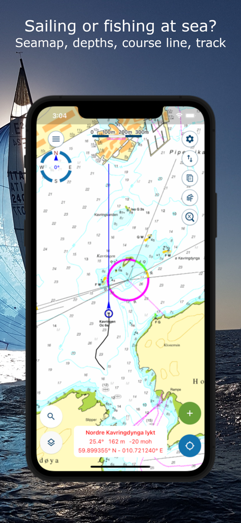
Norgeskart friluftsliv 앱에서 해저 깊이 및 항해 코스 라인이 표시된 해상 지도를 보여줍니다.
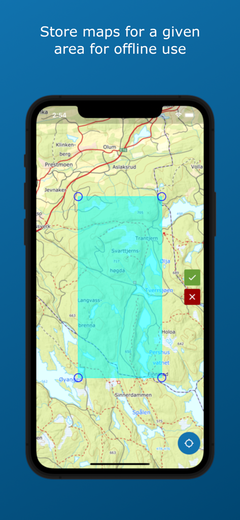
Norgeskart friluftsliv 앱에서 오프라인 사용을 위한 지도 영역 선택
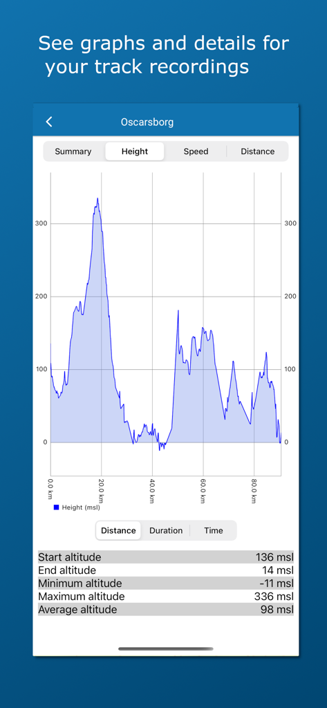
Norgeskart friluftsliv 앱에서 거리별 높이를 보여주는 트랙 기록의 고도 프로필 그래프 및 통계.
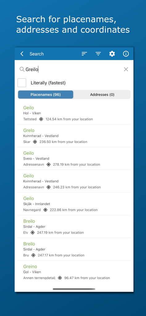
노르웨이 지명 주소 및 좌표를 검색하는 도구
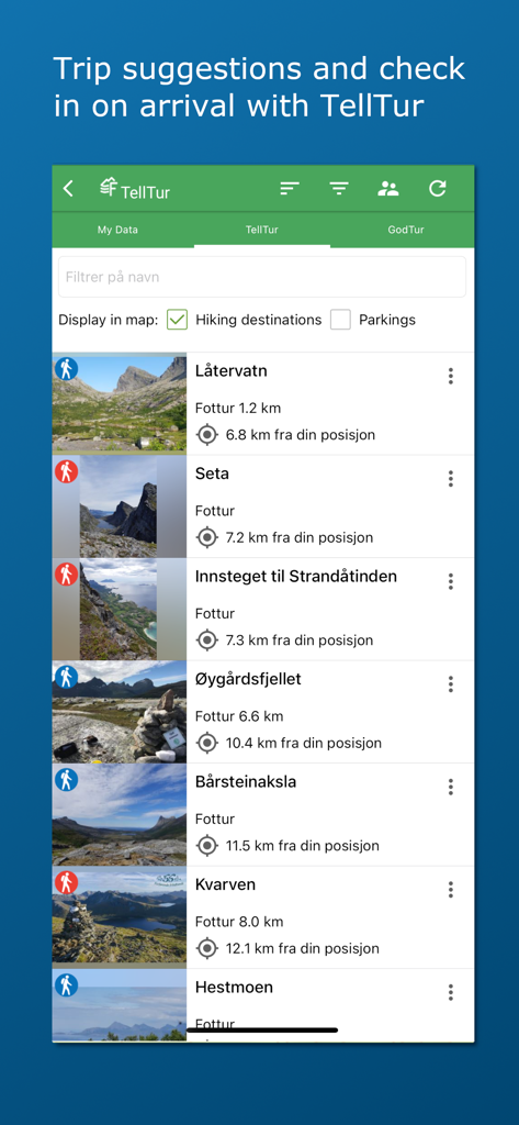
사진 및 거리 정보와 함께 노르웨이의 하이킹 코스 목록과 여행 제안을 보여주는 Norgeskart friluftsliv 앱 인터페이스
설명
Download
비슷한 앱
유사한 기능과 사용자 경험을 가진 앱

AllTrails: Hike, Bike & Run
AllTrails, Inc.

Pedometer++
Cross Forward Consulting, LLC

Organic Maps: Offline Map
Organic Maps OU

Gaia GPS: Mobile Trail Maps
Trailbehind, INC.

Offline hiking maps: Mapy.com
Seznam.cz a.s.

Hiking Map Poland
Mapa Turystyczna sp. z o.o.

MapOut
Valnova GmbH

FarOut: Offline GPS Trail Maps
Atlas Guides DE, Inc.

Norgeskart
Norgeskart AS
이 페이지는 앱이나 개발자의 공식 페이지가 아니며, 정보 제공 및 논평을 목적으로 작성된 독립 편집 간행물입니다. 명시적으로 달리 언급되지 않는 한, 해당 앱이나 개발자는 MWM, Apple, Google Play, 앱 퍼블리셔 또는 앱 개발자와 제휴, 보증, 후원, 승인 또는 공식적으로 연결되어 있지 않으며, 이 페이지의 어떤 내용도 해당 앱이 MWM의 서비스를 사용하여 개발되었음을 의미하지 않습니다. 모든 상표, 로고, 스크린샷 및 기타 콘텐츠는 해당 소유자의 자산입니다.