이 페이지는 앱이나 개발자의 공식 페이지가 아니며, 정보 제공 및 논평을 목적으로 작성된 독립 편집 간행물입니다. 명시적으로 달리 언급되지 않는 한, 해당 앱이나 개발자는 MWM, Apple, Google Play, 앱 퍼블리셔 또는 앱 개발자와 제휴, 보증, 후원, 승인 또는 공식적으로 연결되어 있지 않으며, 이 페이지의 어떤 내용도 해당 앱이 MWM의 서비스를 사용하여 개발되었음을 의미하지 않습니다. 모든 상표, 로고, 스크린샷 및 기타 콘텐츠는 해당 소유자의 자산입니다.

onX Backcountry: Trail GPS App
이 앱은 당신이 길을 잃을 수 있는 변명을 없애버립니다. 지도를 3D로 만들어 손안에 쥐여주고, 통신이 끊겨도 당신을 꼼짝 못하게 하지 않습니다. 즉, 산을 정복하든, 자전거로 돌파하든, 스키로 미끄러져 내려가든, 당신은 언제나 돌아올 길을 알고 있습니다.
다운로드
1M+사용자 평점
총 평가 수
5.7K개발사
카테고리
Navigation지원 언어
1최신 버전
26.13.0크기
433.2 MB출시일
2020년 12월 9일최고 수준의 아웃도어 내비게이션 및 안전 도구 평가
onX Backcountry: Trail GPS App 주요 기능 분석
고급 지형 분석 도구
이 앱은 LiDAR 지형도, 경사도/경사 방향 분석, 눈사태 지형 노출 스케일(ATES) 등 정교한 도구를 제공하여 사용자가 지형의 복잡성과 잠재적 위험을 심층적으로 이해하고 안전한 경로를 계획할 수 있도록 돕습니다.
오프라인 3D 지도 및 GPS 추적
이 도구는 셀 서비스가 없는 원격 지역에서도 안정적인 내비게이션을 위해 3D 지도를 오프라인으로 다운로드할 수 있게 하며, GPS 추적을 통해 사용자의 이동 경로와 주요 통계를 기록할 수 있도록 지원합니다.
위험 및 환경 지도 레이어
이 앱은 산불, 눈사태 지형, 사유지 경계, 최근 위성 이미지, 날씨 및 바람 예보와 같은 다양한 지도 레이어를 제공하여 사용자가 잠재적 위험을 식별하고 환경 조건을 파악하여 더욱 안전하고 책임감 있는 야외 활동을 할 수 있도록 지원합니다.
광범위한 트레일 및 루트 데이터베이스
이 도구는 650,000마일 이상의 하이킹 및 산악자전거 트레일, 300,000개 이상의 암벽 등반 루트, 4,000개 이상의 백컨트리 스키 경로를 포함한 광범위한 정보를 제공하여 사용자가 다양한 활동을 위한 새로운 모험을 계획하고 탐색할 수 있도록 돕습니다.
공공/사유지 정보 및 레크리에이션 아이콘
이 앱은 미국 전역의 공공 및 사유지 경계 정보와 트레일헤드, 야영장 등 55만 개 이상의 레크리에이션 아이콘을 제공하여 사용자가 합법적이고 안전하게 접근할 수 있는 지역을 식별하고 필요한 편의 시설을 쉽게 찾을 수 있도록 돕습니다.
활동별 지도 모드
이 도구는 하이킹, 산악자전거, 백컨트리 스키 등 특정 활동에 최적화된 지도 모드를 제공하여 사용자가 각 활동에 맞는 상세 정보와 지형 맥락을 얻을 수 있도록 돕습니다.
맞춤형 경로 계획 및 경유지 설정
이 앱은 '트레일에 맞춤' 기능으로 사용자가 맞춤형 경로를 쉽게 계획하고, 경유지를 추가하여 관심 지점을 표시할 수 있도록 하여 탐색의 유연성과 개인화된 모험 준비를 가능하게 합니다.
트래커 및 여행 통계 기록
이 도구는 GPS 트래커 기능을 통해 사용자의 이동 경로를 기록하고, 거리, 고도 변화, 이동 속도 등 주요 여행 통계를 측정하여 활동을 분석하고 과거 모험을 검토할 수 있도록 지원합니다.
자주 묻는 질문
에 대해 알아야 할 모든 것 onX Backcountry: Trail GPS App
What is onX Backcountry used for?
onX Backcountry is a GPS map app for outdoor recreation, enabling users to discover and navigate new trails for hiking, skiing, mountain biking, and climbing, even offline.
Does onX Backcountry offer offline navigation?
Yes, onX Backcountry allows users to download 3D maps with interactive trail data for offline use. This turns a phone into a handheld GPS device without cell service.
Can I create custom routes in onX Backcountry?
Yes, onX Backcountry allows users to map custom routes seamlessly with its snap-to-trail feature. Users can also set Waypoints and review detailed slope data for planning.
What types of maps does onX Backcountry provide?
onX Backcountry provides 3D maps, HD topographic maps, satellite imagery, and hybrid views. Users can also select map modes specific to hiking, MTB, climbing, or ski touring.
What safety features are included in onX Backcountry?
onX Backcountry includes safety tools like localized weather forecasts, hourly wind data, and Trail Reports. It also features map layers to monitor wildfire, air quality, and avalanche terrain exposure.
Is there a free trial for onX Backcountry?
Yes, onX Backcountry offers a free seven-day Premium trial upon app installation. This trial provides access to all the app's advanced features for a complete backcountry experience.
What are the exclusive features for onX Backcountry Elite members?
onX Backcountry Elite membership exclusively includes the Private Land Layer, which shows property maps and boundaries, and Recent Imagery, providing detailed satellite views from the past two weeks.
Can onX Backcountry track my outdoor activity statistics?
Yes, onX Backcountry allows users to track their location and measure activity stats. It displays key trip details such as distance, elevation gain, and elevation loss in seconds.
Where can I find the privacy policy for onX Backcountry?
The official privacy policy for onX Backcountry is available on the onXmaps website. You can find the detailed policy at https://www.onxmaps.com/privacy-policy.
Does onX Backcountry provide detailed trail information?
Yes, onX Backcountry offers a "Guidebook Experience" with detailed trail descriptions. This includes trail lengths, difficulty levels, elevation profiles, and user reviews for various routes.
다음 스크린샷과 설명은 앱의 공식 스토어 목록에서 직접 가져온 것이며 앱 개발자의 자산입니다.
앱 스토어
스크린샷
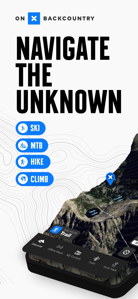
사용자는 3D 지형도에서 고정밀 지도를 확인하고, 스키, MTB, 하이킹, 클라이밍 등 다양한 활동 모드를 선택할 수 있습니다.
모험의 시작
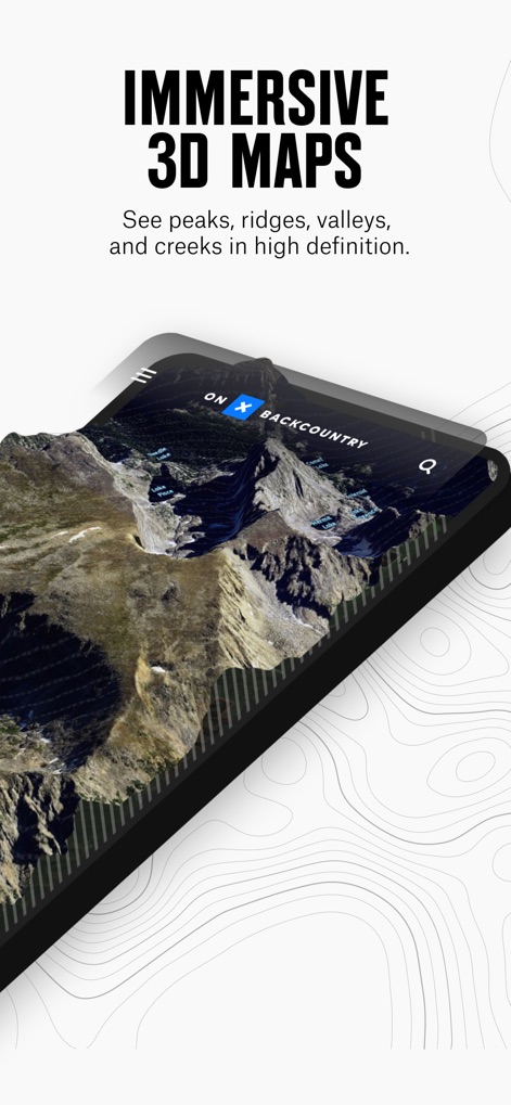
이 앱은 고해상도 3D 지도를 제공하여 사용자가 봉우리, 능선, 계곡 등 실제와 같은 지형을 몰입적으로 탐색할 수 있게 합니다.
몰입형 3D 지도
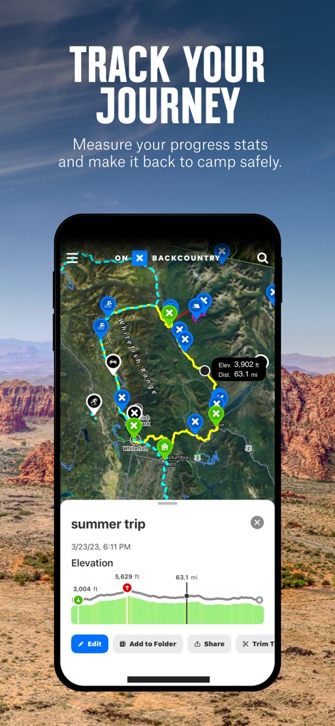
사용자는 GPS 추적 기능을 통해 자신의 이동 경로를 시각적으로 확인하고, 상세한 고도 프로필을 통해 거리 및 고도 변화를 분석할 수 있습니다.
여정 추적
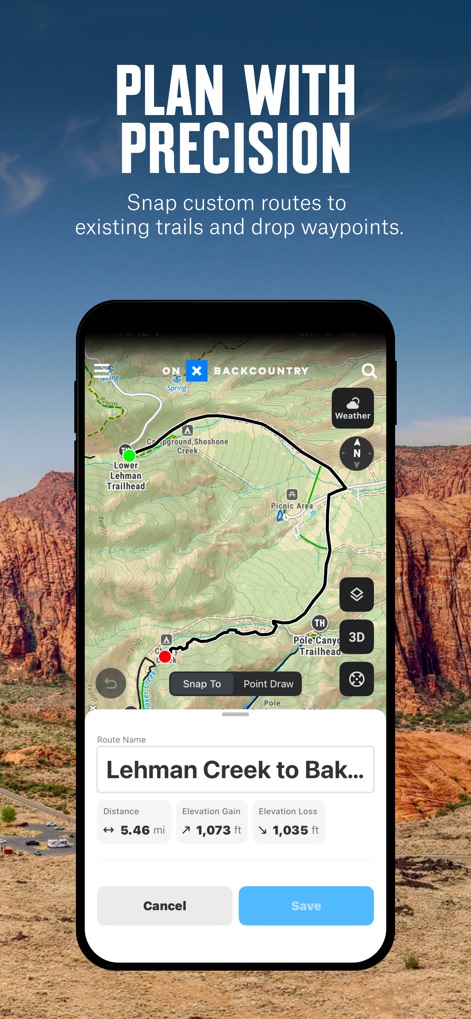
이 도구는 스냅-투-트레일 기능을 통해 사용자가 맞춤형 경로를 쉽게 계획하고, 해당 경로의 예상 거리와 고도 정보를 즉시 확인할 수 있도록 돕습니다.
정밀한 경로 계획
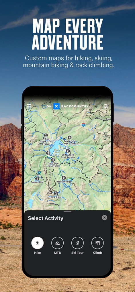
이 앱은 광범위한 트레일 정보를 지도에 표시하며, 사용자가 하이킹, MTB, 스키 투어 등 활동에 최적화된 지도 모드를 선택할 수 있게 합니다.
모든 모험 지도
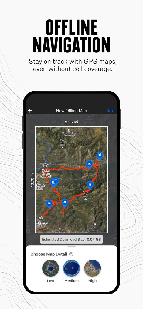
사용자는 모바일 서비스가 없는 지역에서도 오프라인 지도를 다운로드하여 길을 찾을 수 있으며, 필요에 따라 지도 상세도를 조절하여 저장할 수 있습니다.
오프라인 내비게이션
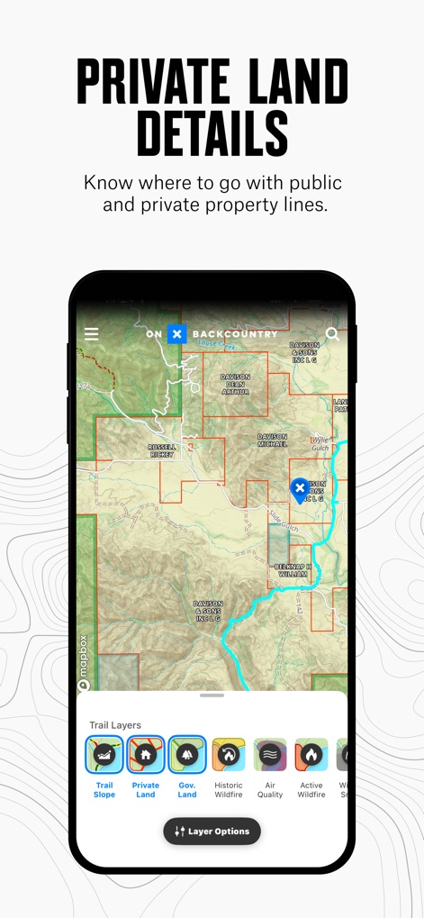
이 앱은 지도에 사유지 경계선을 명확하게 표시하여 사용자가 책임감 있게 탐험할 수 있도록 돕고, 산불, 사유지 등 유용한 지도 레이어를 제공합니다.
사유지 정보 확인
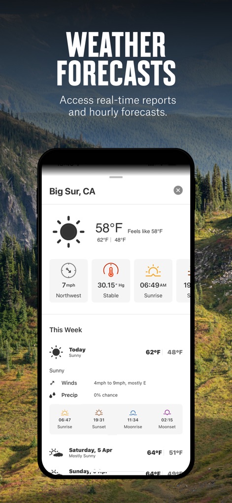
사용자는 현재 기온, 풍속 등 실시간 날씨 정보를 확인하고, 주간 일기 예보를 통해 야외 활동 계획을 정밀하게 세울 수 있습니다.
실시간 날씨 예보
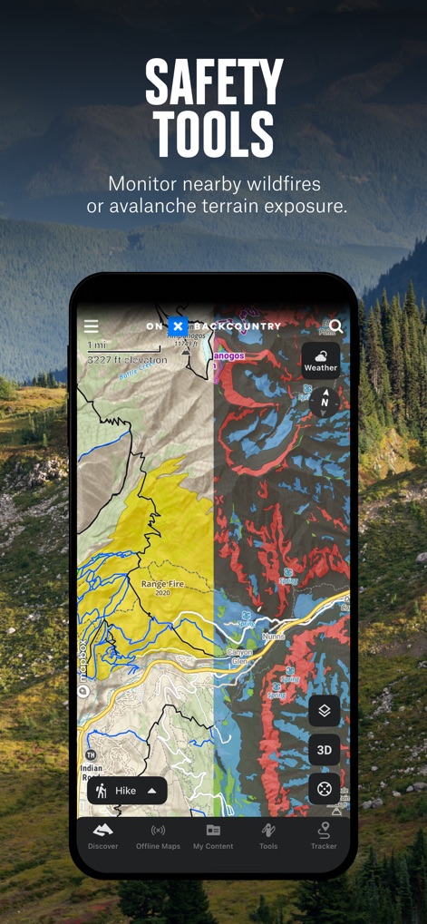
이 앱은 잠재적인 위험을 사전에 인지할 수 있도록 산불 위험 구역과 눈사태 위험 지형 같은 고급 안전 지도 레이어를 제공합니다.
안전 도구 활용

이 도구는 Rim Overlook Trail과 같은 경로에 대한 상세한 설명과 함께, 총 거리 및 고도 상승과 같은 핵심 정보를 제공합니다.
가이드북 경험
설명
Download
비슷한 앱
유사한 기능과 사용자 경험을 가진 앱

AllTrails: Hike, Bike & Run
AllTrails, Inc.

Pedometer++
Cross Forward Consulting, LLC

Organic Maps: Offline Map
Organic Maps OU

Gaia GPS: Mobile Trail Maps
Trailbehind, INC.

Offline hiking maps: Mapy.com
Seznam.cz a.s.

Hiking Map Poland
Mapa Turystyczna sp. z o.o.

MapOut
Valnova GmbH

FarOut: Offline GPS Trail Maps
Atlas Guides DE, Inc.

Norgeskart
Norgeskart AS
이 페이지는 앱이나 개발자의 공식 페이지가 아니며, 정보 제공 및 논평을 목적으로 작성된 독립 편집 간행물입니다. 명시적으로 달리 언급되지 않는 한, 해당 앱이나 개발자는 MWM, Apple, Google Play, 앱 퍼블리셔 또는 앱 개발자와 제휴, 보증, 후원, 승인 또는 공식적으로 연결되어 있지 않으며, 이 페이지의 어떤 내용도 해당 앱이 MWM의 서비스를 사용하여 개발되었음을 의미하지 않습니다. 모든 상표, 로고, 스크린샷 및 기타 콘텐츠는 해당 소유자의 자산입니다.