이 페이지는 앱이나 개발자의 공식 페이지가 아니며, 정보 제공 및 논평을 목적으로 작성된 독립 편집 간행물입니다. 명시적으로 달리 언급되지 않는 한, 해당 앱이나 개발자는 MWM, Apple, Google Play, 앱 퍼블리셔 또는 앱 개발자와 제휴, 보증, 후원, 승인 또는 공식적으로 연결되어 있지 않으며, 이 페이지의 어떤 내용도 해당 앱이 MWM의 서비스를 사용하여 개발되었음을 의미하지 않습니다. 모든 상표, 로고, 스크린샷 및 기타 콘텐츠는 해당 소유자의 자산입니다.

OS Maps: Walk, Hike, Run, Bike
3D 지형 지도, 실시간 안전 경고, 안정적인 오프라인 GPS를 통해 최고의 정밀도로 트레일 계획을 경험하세요. 한계 없이 하이킹, 자전거, 달리기를 하는 체계적인 탐험가를 위해 설계되었습니다.
다운로드
2M+사용자 평점
총 평가 수
90K+개발사
카테고리
Navigation지원 언어
1최신 버전
5.5.5크기
202.8 MB출시일
2015년 6월 10일체계적인 탐험가를 위한 정밀 도구
심각한 야외 모험을 위해 설계된 기술적인 매핑, 원활한 멀티 디바이스 계획, 고급 안전 기능으로 기본을 넘어서세요.
모든 능선을 3D로 시각화하세요
뛰어난 상황 인식을 위해 멋진 3D 지도 레이어와 상세한 지형 데이터로 도착 전에 풍경을 이해하세요.
랩톱에서 언덕까지 동기화
자동 '경로 스냅' 기술로 데스크톱에서 정밀 경로를 계획하고 iPhone 및 Apple Watch와 즉시 동기화하세요.
자주 묻는 질문
에 대해 알아야 할 모든 것 OS Maps: Walk, Hike, Run, Bike
OS 지도는 무엇인가요?
OS Maps는 미국 전역의 하이킹, 자전거 타기, 달리기와 같은 야외 활동을 안내하도록 설계된 애플리케이션입니다. 국립공원, 지역 동네, 해안 지역의 트레일을 발견하고 계획하는 데 도움이 됩니다.
OS 지도에서 지원하는 야외 활동에는 어떤 종류가 있나요?
OS Maps는 하이킹, 자전거 타기, 달리기를 포함한 다양한 야외 활동을 지원합니다. 다양한 지형과 장소에서 이러한 활동을 위한 상세한 지도와 안내를 제공합니다.
사용자는 OS 지도에서 자신만의 경로를 만들 수 있나요?
네, OS Maps를 사용하면 사용자는 자신만의 트레일을 계획하여 따르고, 공유하고, 기록할 수 있습니다. 이 앱은 또한 웨이포인트 간의 쉬운 경로 계획을 위해 자동 '경로에 스냅' 기능을 제공합니다.
OS 지도는 오프라인 지도 사용을 지원하나요?
네, OS Maps는 오프라인 지도 사용을 지원합니다. 사용자는 셀 수신 없이 지도와 선택한 경로를 보기 위해 즐겨찾는 지역을 다운로드할 수 있습니다. 또한 GPX 장치로 트레일과 경로를 내보낼 수 있습니다.
OS 지도에서 사용할 수 있는 지도 레이어는 무엇인가요?
OS Maps는 상세한 지형 지도, 항공 보기, 3D 지도 레이어를 포함한 여러 지도 레이어를 제공합니다. 이러한 옵션을 통해 사용자는 다양한 수준의 세부 정보로 풍경을 탐색할 수 있습니다.
OS 지도는 실시간 GPS 추적 및 안전 기능을 제공하나요?
네, OS Maps는 사용자가 경로를 벗어나지 않도록 실시간 GPS 위치 추적 및 경로 이탈 경고를 제공합니다. 또한 다른 사용자의 실시간 트레일 상태 업데이트를 위한 커뮤니티 경고도 포함되어 있습니다.
OS 지도는 여러 기기에서 호환되나요?
네, OS Maps를 사용하면 단일 계정으로 여러 기기에서 경로와 활동을 보고, 만들고, 동기화할 수 있습니다. 데스크톱에서 계획하고 모바일 및 Apple Watch에서 기록하는 것을 지원합니다.
사용자는 OS 지도에서 지도를 인쇄할 수 있나요?
네, OS Maps는 무제한 인쇄 기능을 제공합니다. 사용자는 야외 활동 중에 물리적 백업을 위해 트레일과 지도의 복사본을 인쇄할 수 있습니다.
OS 지도 구독 비용은 얼마인가요?
OS Maps의 월간 구독 비용은 $4.99입니다. 연간 구독은 $28.99에 제공되며 앱의 기능에 대한 프리미엄 액세스를 제공합니다.
OS 지도 구독을 어떻게 관리하거나 취소할 수 있나요?
구매 후 App Store 앱을 통해 OS Maps 구독을 관리할 수 있습니다. iOS 설정의 구독 목록에 액세스하여 언제든지 구독을 취소할 수 있습니다.
OS 지도 구독은 자동 갱신되나요?
네, OS Maps 구독은 기본적으로 자동 갱신됩니다. 사용자가 현재 청구 기간이 끝나기 최소 24시간 전에 구독을 취소하지 않으면 자동으로 갱신됩니다.
OS 지도에 대한 지원은 어디에서 찾을 수 있나요?
사용자는 https://www.ordnancesurvey.co.uk/contact-us에서 연락 페이지를 방문하여 OS 지도에 대한 지원을 찾고 문제를 신고할 수 있습니다. 이 링크는 피드백 및 문제 해결을 위해 제공됩니다.
다음 스크린샷과 설명은 앱의 공식 스토어 목록에서 직접 가져온 것이며 앱 개발자의 자산입니다.
앱 스토어
스크린샷

배낭을 멘 두 명의 하이커가 일몰 시 언덕을 오르고 있으며, 'Adventure Outside'라는 문구와 App Store 편집자 추천 배지가 표시됩니다.
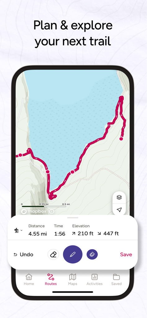
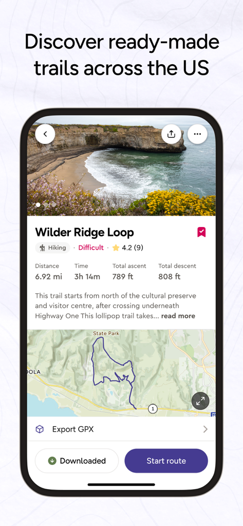
OS Maps 앱 인터페이스가 표시된 스마트폰으로, 거리, 시간, 고도 통계가 포함된 해안 하이킹 경로가 계획되어 있습니다.
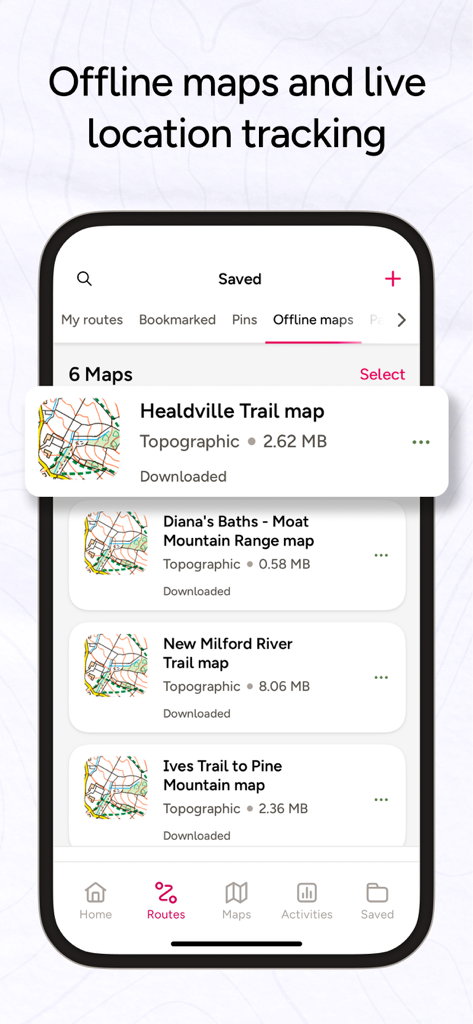
OS Maps 모바일 앱 인터페이스로, 하이킹 및 내비게이션을 위한 저장된 오프라인 지형 트레일 지도 목록을 보여줍니다.
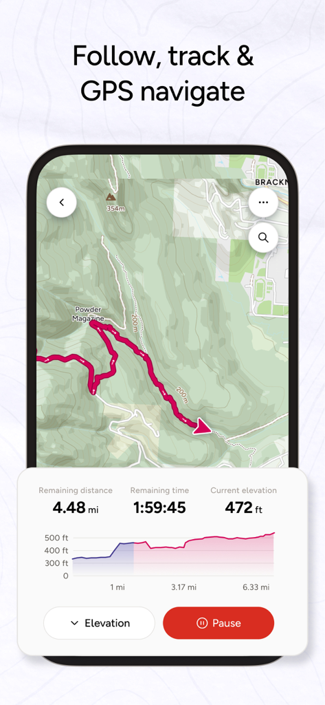
OS Maps 앱 인터페이스로, 하이킹 경로에 대한 실시간 GPS 추적 및 고도 프로필을 보여줍니다.
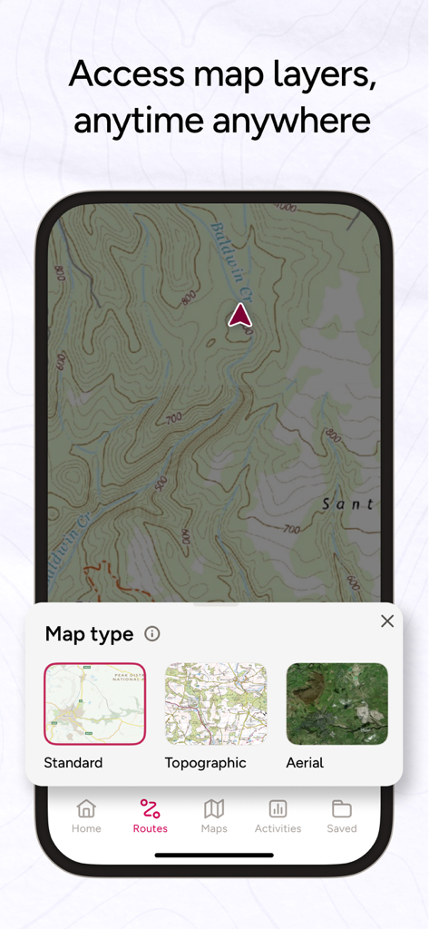
OS Maps 앱 인터페이스로, 지형도를 표시하고 표준, 지형, 항공 지도 레이어 선택 메뉴를 보여줍니다.

산악 트레일에 있는 두 명의 하이커와 OS Maps에 대한 별 다섯 개 리뷰
OS Maps 모바일 앱 인터페이스로, 거리, 고도, 경로 지도를 포함한 하이킹 트레일 세부 정보를 보여줍니다.
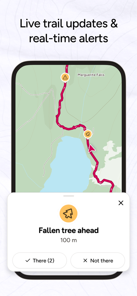
OS Maps 인터페이스로, 넘어진 나무와 같은 트레일 위험에 대한 실시간 커뮤니티 경고를 표시합니다.
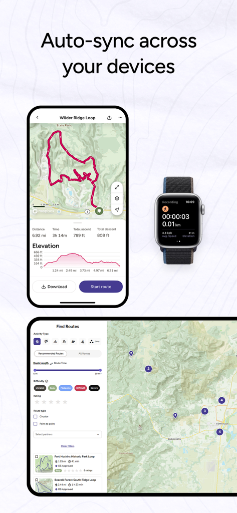
iPhone, Apple Watch 및 태블릿 전반에 걸쳐 동기화된 OS Maps 앱 인터페이스로, 경로 세부 정보 및 활동 추적을 보여줍니다.
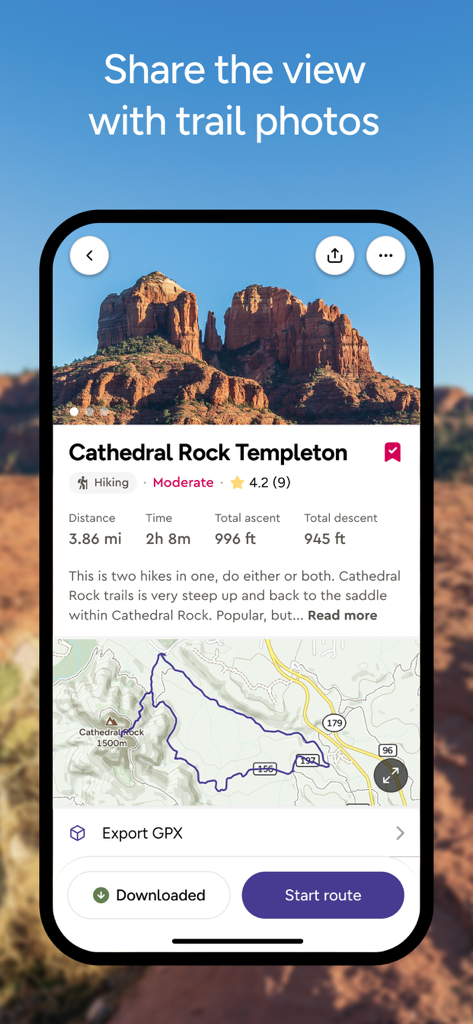
OS Maps 모바일 앱으로 Cathedral Rock Templeton의 하이킹 경로 세부 정보, 지도 및 고도 통계 표시
설명
Download
비슷한 앱
유사한 기능과 사용자 경험을 가진 앱

AllTrails: Hike, Bike & Run
AllTrails, Inc.

Pedometer++
Cross Forward Consulting, LLC

Organic Maps: Offline Map
Organic Maps OU

Gaia GPS: Mobile Trail Maps
Trailbehind, INC.

Offline hiking maps: Mapy.com
Seznam.cz a.s.

Hiking Map Poland
Mapa Turystyczna sp. z o.o.

MapOut
Valnova GmbH

FarOut: Offline GPS Trail Maps
Atlas Guides DE, Inc.

Norgeskart
Norgeskart AS
이 페이지는 앱이나 개발자의 공식 페이지가 아니며, 정보 제공 및 논평을 목적으로 작성된 독립 편집 간행물입니다. 명시적으로 달리 언급되지 않는 한, 해당 앱이나 개발자는 MWM, Apple, Google Play, 앱 퍼블리셔 또는 앱 개발자와 제휴, 보증, 후원, 승인 또는 공식적으로 연결되어 있지 않으며, 이 페이지의 어떤 내용도 해당 앱이 MWM의 서비스를 사용하여 개발되었음을 의미하지 않습니다. 모든 상표, 로고, 스크린샷 및 기타 콘텐츠는 해당 소유자의 자산입니다.