이 페이지는 앱이나 개발자의 공식 페이지가 아니며, 정보 제공 및 논평을 목적으로 작성된 독립 편집 간행물입니다. 명시적으로 달리 언급되지 않는 한, 해당 앱이나 개발자는 MWM, Apple, Google Play, 앱 퍼블리셔 또는 앱 개발자와 제휴, 보증, 후원, 승인 또는 공식적으로 연결되어 있지 않으며, 이 페이지의 어떤 내용도 해당 앱이 MWM의 서비스를 사용하여 개발되었음을 의미하지 않습니다. 모든 상표, 로고, 스크린샷 및 기타 콘텐츠는 해당 소유자의 자산입니다.

OsmAnd Maps Travel & Navigate
데이터 연결이 끊겼을 때도 길을 잃지 않는 것은 단순한 편리함이 아니라, 지배력입니다. OsmAnd는 오프라인 환경에서 정밀한 지도를 제공하며, 사용자에게 무한한 탐험의 자유를 선사합니다.
다운로드
2.5M+사용자 평점
총 평가 수
39.1K개발사
카테고리
Travel지원 언어
77최신 버전
5.2.3크기
245.6 MB출시일
2015년 4월 21일경험이 풍부한 여행자 및 야외 활동 전문가를 위한 종합 평가
OsmAnd Maps Travel & Navigate: 핵심 기능 분석
오프라인 지도 및 내비게이션
이 앱은 인터넷 연결 없이도 전 세계 지도를 다운로드하여 사용할 수 있으며, 경로를 계획하고 탐색할 수 있는 강력한 오프라인 기능을 제공합니다. 특히 인터넷 접속이 어려운 지역에서 신뢰할 수 있는 길 안내를 가능하게 합니다.
고급 경로 계획 및 GPX 트랙 관리
사용자는 포인트를 지정하여 세부적인 경로를 계획하고, GPX 트랙을 기록하며, 직접 생성하거나 가져온 GPX 트랙을 지도에 표시하고 따라 내비게이션할 수 있습니다. 이는 복잡한 모험이나 전문적인 탐색에 유용합니다.
맞춤형 GPS 내비게이션 프로필
이 도구는 자동차, 오토바이, 자전거, 4x4 차량, 보행자, 보트 등 다양한 이동 수단에 맞춰 사용자 지정 가능한 내비게이션 프로필을 제공합니다. 이를 통해 각 활동에 최적화된 경로 안내를 받을 수 있습니다.
세부적인 지도 스타일 및 지형 정보
이 앱은 관광, 해상, 겨울 스키, 지형도, 사막, 오프로드 등 다양한 활동에 맞춘 지도 스타일을 지원하며, 음영 기복 및 등고선 플러그인을 통해 상세한 지형 정보를 제공합니다. 이는 환경 이해도를 높여줍니다.
사용자 데이터 비수집 및 오픈 소스
이 도구는 오픈 소스 기반으로 사용자 데이터를 수집하지 않으며, 사용자가 앱이 접근할 데이터 권한을 직접 결정할 수 있도록 합니다. 이는 개인 정보 보호를 중시하는 사용자에게 높은 신뢰를 제공합니다.
OpenStreetMap 편집 및 최신 지도 업데이트
이 앱은 OpenStreetMap에 직접 편집을 기여할 수 있는 기능을 제공하며, 최대 1시간 간격으로 지도를 업데이트하여 항상 최신 정보를 반영할 수 있게 합니다. 이는 지도 정확도와 커뮤니티 참여를 촉진합니다.
맞춤형 내비게이션 정보 위젯
이 도구는 거리, 속도, 남은 이동 시간, 다음 회전까지의 거리 등 경로 관련 정보를 보여주는 사용자 지정 가능한 위젯을 제공합니다. 이는 운전 중이나 이동 중에 중요한 정보를 한눈에 확인할 수 있게 해줍니다.
유연한 관심 지점(POI) 관리
사용자는 즐겨찾기 및 마커 기능을 통해 지도 상에 중요한 장소를 쉽게 저장하고 관리할 수 있습니다. 이는 개인화된 탐색 경험과 특정 장소로의 빠른 접근을 돕습니다.
자주 묻는 질문
에 대해 알아야 할 모든 것 OsmAnd Maps Travel & Navigate
Can OsmAnd Maps Travel & Navigate be used offline?
Yes, OsmAnd Maps Travel & Navigate is an offline world map application allowing navigation and GPX track recording without an internet connection.
Does OsmAnd Maps Travel & Navigate collect user data?
No, OsmAnd Maps Travel & Navigate does not collect user data. It is an open-source app, giving users control over data access.
Does OsmAnd Maps Travel & Navigate support navigation for various vehicle types?
Yes, OsmAnd offers customizable navigation profiles for various vehicles, including cars, motorcycles, bicycles, 4x4, pedestrians, boats, and public transport.
What features are included with an OsmAnd Maps+ subscription?
An OsmAnd Maps+ subscription includes unlimited map downloads, topo data, nautical depths, offline Wikipedia, and Apple CarPlay support.
Can users contribute to OpenStreetMap directly through OsmAnd Maps Travel & Navigate?
Yes, OsmAnd Maps Travel & Navigate allows users to make edits to OpenStreetMap (OSM), facilitating contributions to the map data directly.
Does OsmAnd Maps Travel & Navigate offer hourly map updates?
Yes, OsmAnd Pro subscription provides hourly map updates. The base app offers updates with a frequency of up to one hour for OpenStreetMap.
How can users search for points of interest in OsmAnd Maps Travel & Navigate?
Users can search for places in OsmAnd by address, name, coordinates, or category. The app displays various POI types like attractions, food, and health.
Can I plan a multi-point route using OsmAnd Maps Travel & Navigate?
Yes, OsmAnd Maps Travel & Navigate supports plotting a route point by point using one or multiple navigation profiles.
What topographic features does OsmAnd Maps Travel & Navigate provide?
OsmAnd offers shading relief, plug-in contour lines, and topographic map styles. The OsmAnd Maps+ subscription includes additional topo data.
Does OsmAnd Maps Travel & Navigate allow recording of GPX tracks?
Yes, OsmAnd Maps Travel & Navigate enables route recording using GPX tracks and provides tools to manage and display them on the map.
다음 스크린샷과 설명은 앱의 공식 스토어 목록에서 직접 가져온 것이며 앱 개발자의 자산입니다.
앱 스토어
스크린샷
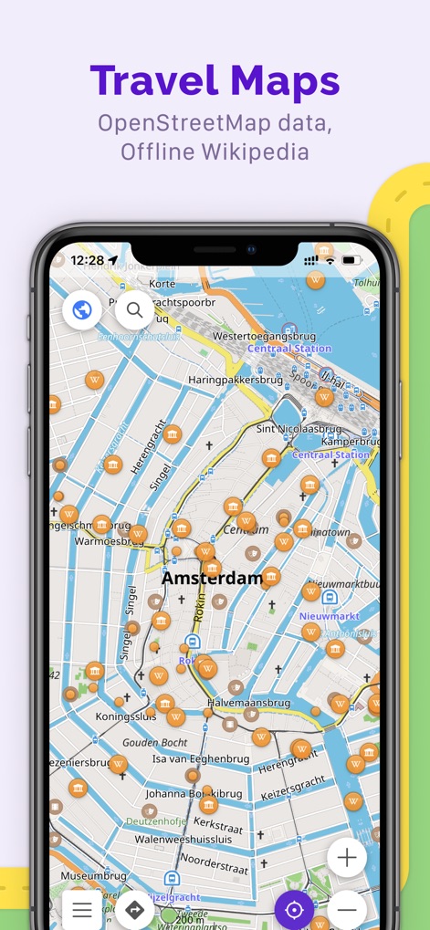
이 앱은 OpenStreetMap 데이터를 활용하여 암스테르담의 상세한 지도를 제공하며, 다양한 관심 지점(POI) 아이콘과 함께 오프라인 위키피디아 정보를 확인할 수 있습니다.
여행 지도 탐색

이 화면은 오프라인에서도 스톡홀름을 탐색할 수 있는 기능을 보여주며, 사용자에게 자동차, 자전거, 도보 등 다양한 이동 수단에 맞춘 맞춤형 길 안내 프로필을 제공합니다.
오프라인 길 안내
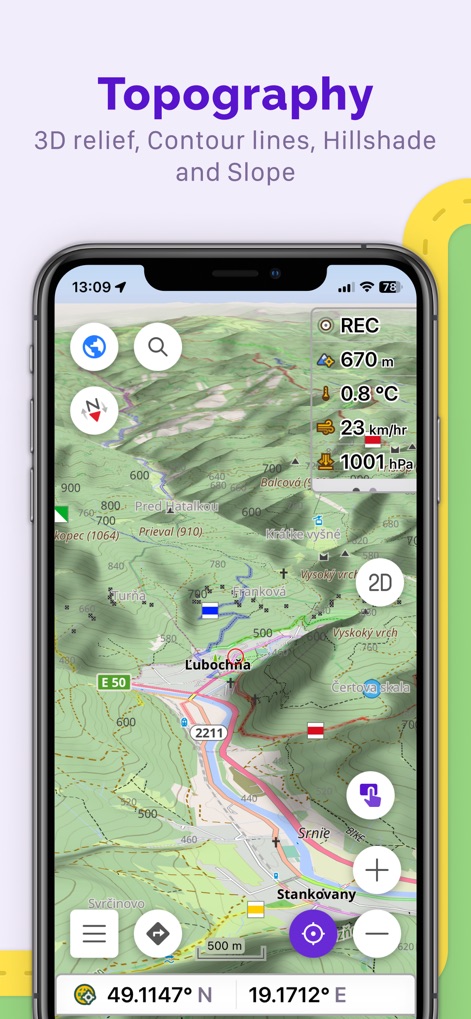
이 앱은 상세한 등고선과 함께 지형을 시각화하여 산악 지형 탐험에 유용하며, 현재 온도와 고도와 같은 실시간 정보 위젯을 통해 환경 데이터를 제공합니다.
상세 지형 탐험
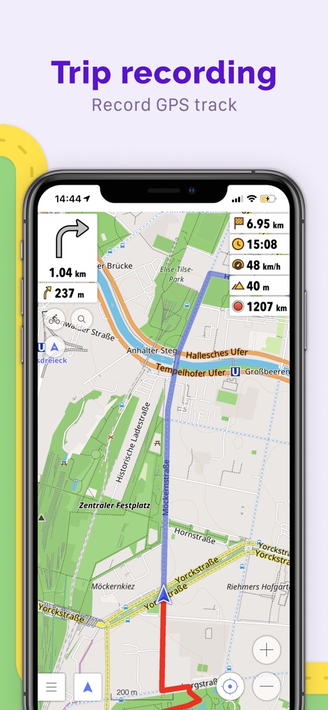
사용자는 이 화면에서 자신의 이동 경로를 GPX 트랙으로 정밀하게 기록할 수 있으며, 기록된 경로의 총 거리와 고도 변화를 포함한 상세 통계를 한눈에 볼 수 있습니다.
이동 경로 기록
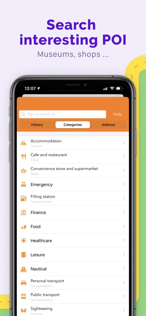
이 도구는 숙박 시설, 카페 및 응급 시설과 같은 다양한 카테고리별로 관심 지점을 편리하게 검색할 수 있도록 지원하며, 사용자에게 필요한 특정 장소를 쉽게 찾을 수 있게 합니다.
관심 지점 검색

이 앱은 나침반과 반경 측정기와 같은 유용한 여행 도구를 제공하며, 현재 온도 및 이동 속도와 같은 핵심 정보를 표시하는 맞춤형 위젯을 통해 사용자 경험을 향상시킵니다.
맞춤형 여행 도구
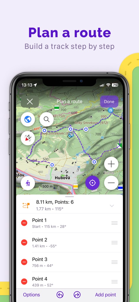
이 화면은 여러 지점을 추가하여 단계별로 정교한 경로를 계획할 수 있는 기능을 보여주며, 각 지점 간의 거리와 방향에 대한 세부 정보를 제공합니다.
정교한 경로 계획

사용자는 특정 장소에 마커를 설정하여 즐겨찾기 또는 관심 지점을 쉽게 표시할 수 있으며, 해당 마커까지의 거리와 예상 이동 시간을 즉시 확인할 수 있습니다.
위치 마커 활용
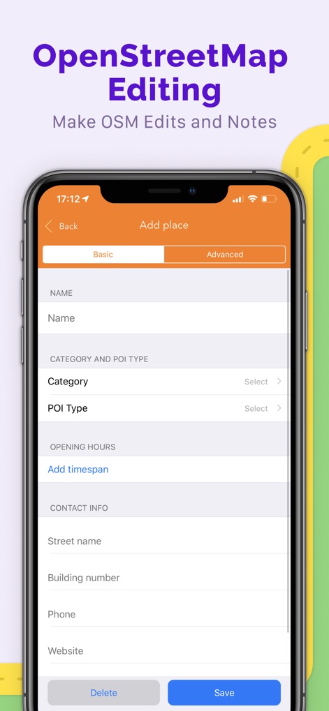
이 앱은 OpenStreetMap 데이터를 직접 편집하고 새로운 장소를 추가할 수 있는 기능을 제공하며, 사용자는 카테고리 및 POI 유형과 같은 세부 정보를 기여할 수 있습니다.
오픈스트리트맵 편집
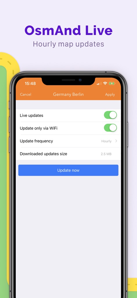
이 화면은 지도를 실시간으로 업데이트할 수 있는 'OsmAnd Live' 기능을 보여주며, 사용자는 업데이트 빈도를 시간 단위로 설정하거나 Wi-Fi를 통해서만 업데이트하도록 선택할 수 있습니다.
실시간 지도 업데이트
설명
Download
비슷한 앱
유사한 기능과 사용자 경험을 가진 앱

AllTrails: Hike, Bike & Run
AllTrails, Inc.

Pedometer++
Cross Forward Consulting, LLC

Organic Maps: Offline Map
Organic Maps OU

Gaia GPS: Mobile Trail Maps
Trailbehind, INC.

Offline hiking maps: Mapy.com
Seznam.cz a.s.

Hiking Map Poland
Mapa Turystyczna sp. z o.o.

MapOut
Valnova GmbH

FarOut: Offline GPS Trail Maps
Atlas Guides DE, Inc.

Norgeskart
Norgeskart AS
이 페이지는 앱이나 개발자의 공식 페이지가 아니며, 정보 제공 및 논평을 목적으로 작성된 독립 편집 간행물입니다. 명시적으로 달리 언급되지 않는 한, 해당 앱이나 개발자는 MWM, Apple, Google Play, 앱 퍼블리셔 또는 앱 개발자와 제휴, 보증, 후원, 승인 또는 공식적으로 연결되어 있지 않으며, 이 페이지의 어떤 내용도 해당 앱이 MWM의 서비스를 사용하여 개발되었음을 의미하지 않습니다. 모든 상표, 로고, 스크린샷 및 기타 콘텐츠는 해당 소유자의 자산입니다.