이 페이지는 앱이나 개발자의 공식 페이지가 아니며, 정보 제공 및 논평을 목적으로 작성된 독립 편집 간행물입니다. 명시적으로 달리 언급되지 않는 한, 해당 앱이나 개발자는 MWM, Apple, Google Play, 앱 퍼블리셔 또는 앱 개발자와 제휴, 보증, 후원, 승인 또는 공식적으로 연결되어 있지 않으며, 이 페이지의 어떤 내용도 해당 앱이 MWM의 서비스를 사용하여 개발되었음을 의미하지 않습니다. 모든 상표, 로고, 스크린샷 및 기타 콘텐츠는 해당 소유자의 자산입니다.

PRO CHARTS - Marine Navigation
오프라인 NOAA 지도, 쉬운 항로 계획, 실시간 친구 추적 기능으로 iPhone 또는 iPad를 고해상도 차트플로터로 바꾸세요. 셀룰러 신호가 필요하지 않습니다.
다운로드
609K+사용자 평점
총 평가 수
13K+개발사
카테고리
Navigation지원 언어
22최신 버전
5.70크기
45.0 MB출시일
2011년 8월 4일전문 선장처럼 항해하세요
전문 등급 NOAA 차트와 고급 안전 기능으로 iPhone 또는 iPad를 고성능 선박 GPS로 변환하세요.
고해상도 NOAA 차트
모든 미국 연안 해역 및 주요 강 시스템에 대한 수심 데이터를 포함한 공식적이고 상세한 해도에 액세스하세요.
안정적인 오프라인 항해
셀룰러 신호 없이 작동하도록 설계되었습니다. 차트를 미리 캐시하고 완전한 자신감으로 먼 바다를 항해하세요.
다음 스크린샷과 설명은 앱의 공식 스토어 목록에서 직접 가져온 것이며 앱 개발자의 자산입니다.
앱 스토어
스크린샷

PRO CHARTS 앱의 해도 항해 인터페이스로, 보트 위치 및 수심 데이터가 표시된 상세한 NOAA 차트를 보여줍니다.
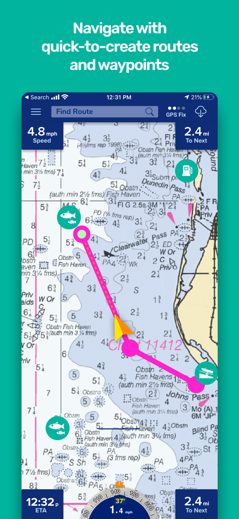
웨이포인트와 항해 통계가 포함된 계획된 보트 경로를 보여주는 해도 인터페이스.
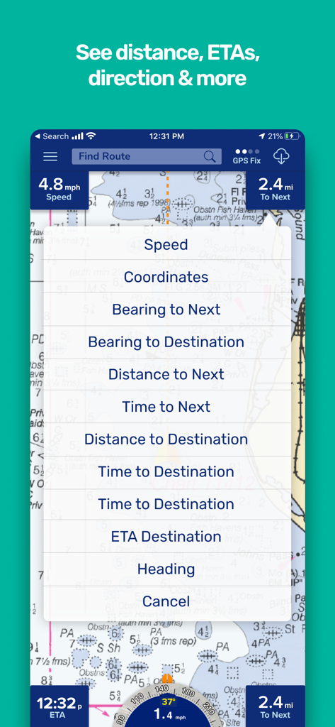
속도, 방위 및 예상 도착 시간과 같은 항해 데이터 옵션을 보여주는 해도 인터페이스
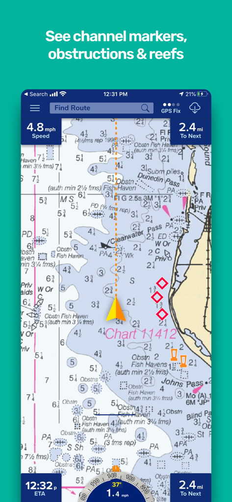
수로 표지와 연안 항해 데이터가 표시된 해도 인터페이스
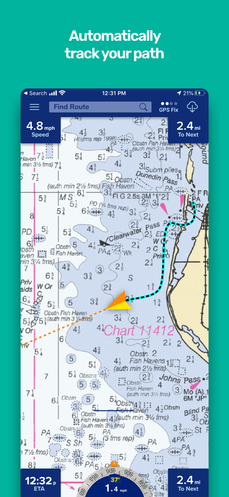
Pro Charts 앱이 해도 상에 추적된 보트 경로를 표시합니다.
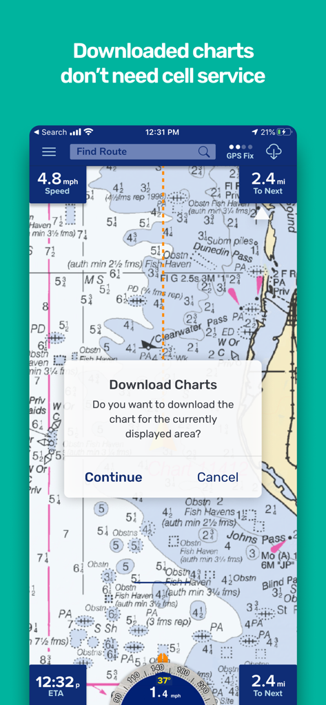
해도와 함께 셀룰러 서비스 없이 오프라인으로 지도를 다운로드하라는 메시지가 표시되는 선박 항해 앱 인터페이스
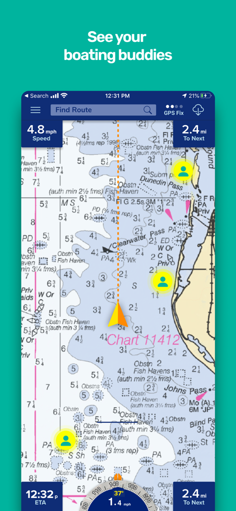
Pro Charts 선박 항해 앱 인터페이스가 해도 상에 친구 추적 기능을 표시합니다.
설명
Download
비슷한 앱
유사한 기능과 사용자 경험을 가진 앱

PredictWind — Marine Forecasts
PredictWind Limited

Navily
The Navigation Family

Argo - Boating Navigation
Argo Navigation, LLC

SEAiq Pilot
Sakhalin, LLC

Maptrails
Pasi Salenius

KartenWerft NavGo 2.0
KartenWerft GmbH

MarineTraffic - Ship Tracking
MARINETRAFFIC APPLICATIONS LTD

Wavve Boating: Marine Boat GPS
Wavve Boating Inc

Savvy Navvy Boating Navigation
SAVVY NAVVY LTD
이 페이지는 앱이나 개발자의 공식 페이지가 아니며, 정보 제공 및 논평을 목적으로 작성된 독립 편집 간행물입니다. 명시적으로 달리 언급되지 않는 한, 해당 앱이나 개발자는 MWM, Apple, Google Play, 앱 퍼블리셔 또는 앱 개발자와 제휴, 보증, 후원, 승인 또는 공식적으로 연결되어 있지 않으며, 이 페이지의 어떤 내용도 해당 앱이 MWM의 서비스를 사용하여 개발되었음을 의미하지 않습니다. 모든 상표, 로고, 스크린샷 및 기타 콘텐츠는 해당 소유자의 자산입니다.