이 페이지는 앱이나 개발자의 공식 페이지가 아니며, 정보 제공 및 논평을 목적으로 작성된 독립 편집 간행물입니다. 명시적으로 달리 언급되지 않는 한, 해당 앱이나 개발자는 MWM, Apple, Google Play, 앱 퍼블리셔 또는 앱 개발자와 제휴, 보증, 후원, 승인 또는 공식적으로 연결되어 있지 않으며, 이 페이지의 어떤 내용도 해당 앱이 MWM의 서비스를 사용하여 개발되었음을 의미하지 않습니다. 모든 상표, 로고, 스크린샷 및 기타 콘텐츠는 해당 소유자의 자산입니다.
RadarScope
레이턴시 없이 원시 NEXRAD Level II 데이터 및 네이티브 레이더 제품을 경험하십시오. 기상학자 및 응급 구조대원이 신뢰하는 동일한 고해상도 도구를 사용하여 토네이도, 허리케인 및 심각한 폭풍을 추적하십시오.
미학보다 정확성을 요구하는 전문가 및 애호가를 위해 설계된 원시 고해상도 레이더 데이터 및 고급 폭풍 추적 도구에 액세스하십시오.
원시 NEXRAD Level II 데이터
스무딩 없이 원래의 방사형 형식으로 레이더 데이터를 볼 수 있어 레이턴시 없이 속도 커플릿 및 잔해 볼을 식별할 수 있습니다.
실시간 악천후 경고
통합 폭풍 경로 및 우박 속성을 갖춘 토네이도, 돌발 홍수 및 심각한 뇌우에 대한 NWS 생성 경고를 모니터링하십시오.
다음 스크린샷과 설명은 앱의 공식 스토어 목록에서 직접 가져온 것이며 앱 개발자의 자산입니다.
앱 스토어
스크린샷
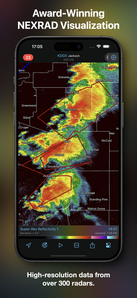
RadarScope 앱이 모바일 장치에서 고해상도 NEXRAD 레이더 데이터를 표시하고 있습니다.
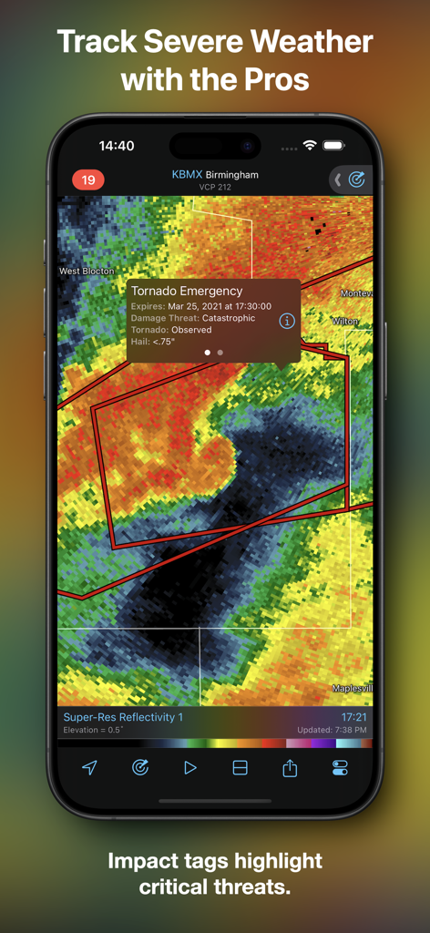
RadarScope 앱이 날씨 레이더 지도에 토네이도 긴급 영향 태그를 표시하고 있습니다.
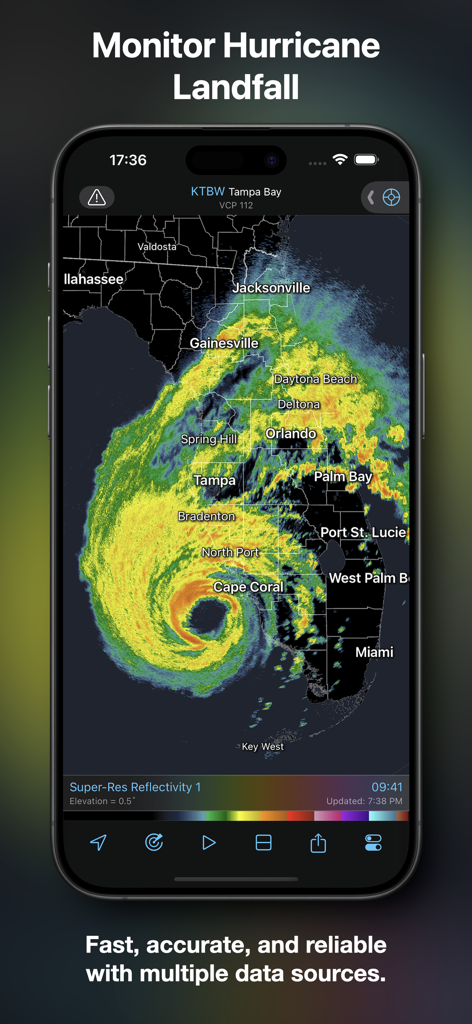
RadarScope 앱 인터페이스가 플로리다 상공의 고해상도 허리케인 레이더 루프를 표시하고 있습니다.
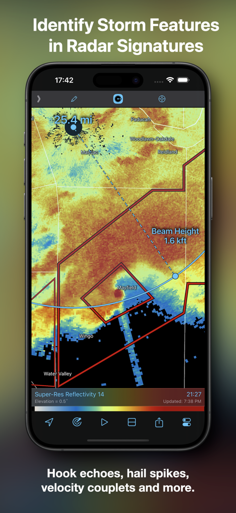
RadarScope 앱 스크린샷으로 거리 및 빔 높이 표시기가 있는 레이더 지도를 표시하여 폭풍 특징을 식별합니다.
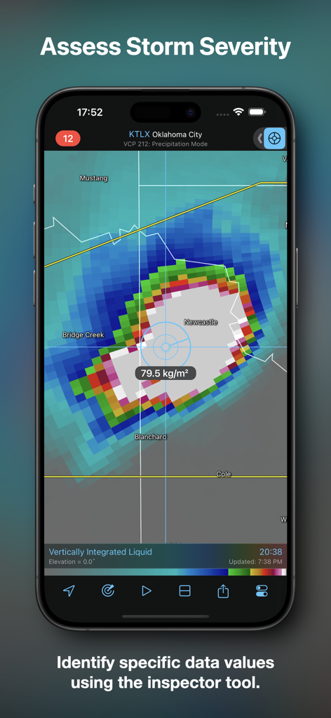
RadarScope 앱 인터페이스가 검사기 도구를 사용하여 폭풍 심각도를 평가하는 것을 보여줍니다.
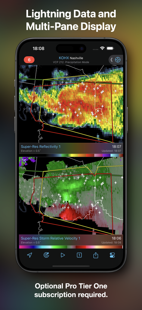
RadarScope 앱의 스크린샷으로 초해상도 반사도 및 번개 데이터를 포함한 폭풍 상대 속도가 있는 분할 화면 보기를 보여줍니다.
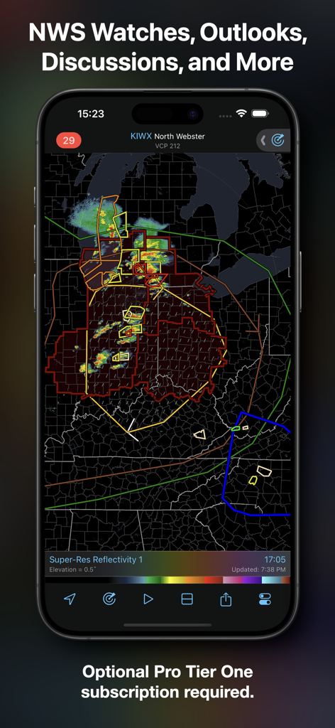
RadarScope 앱 인터페이스가 고해상도 레이더 지도에 미국 국립기상청의 감시 및 전망을 표시하고 있습니다.
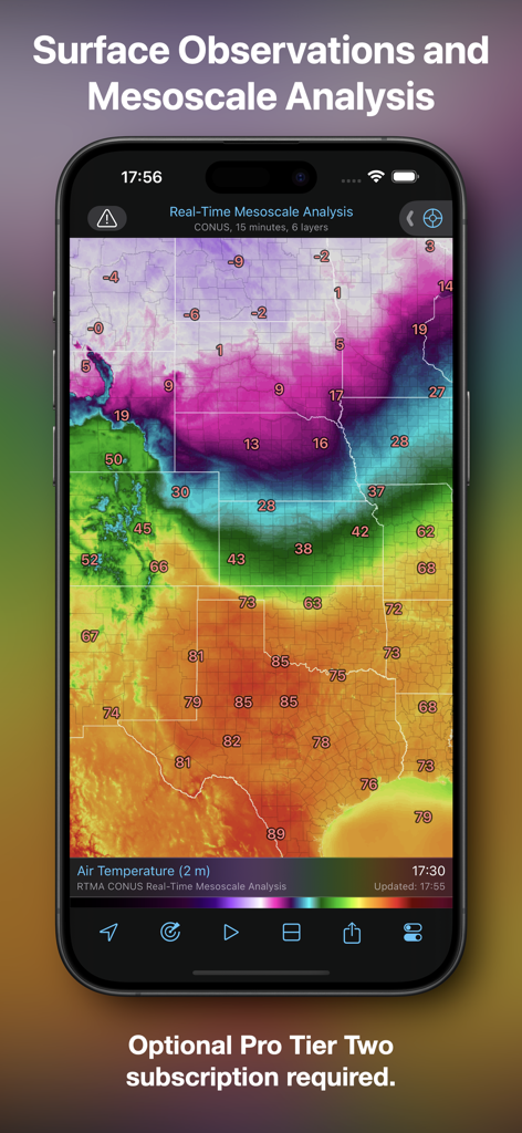
RadarScope 앱이 실시간 중간규모 분석 및 지표 온도 관측을 보여줍니다.
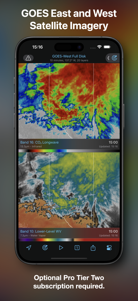
RadarScope 모바일 앱이 적외선 및 수증기 계층이 있는 GOES 동쪽 및 서쪽 위성 이미지를 표시하고 있습니다.
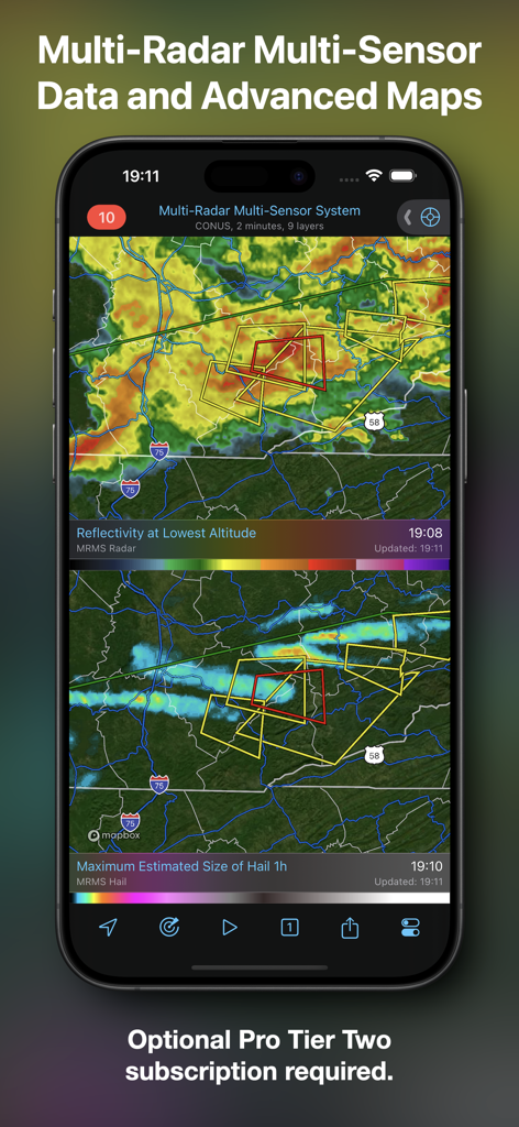
RadarScope 앱 인터페이스가 반사도 및 우박 크기 데이터가 있는 고급 날씨 지도를 보여줍니다.
설명
RadarScope is an AMS-award-winning weather visualization tool that empowers meteorologists, public safety officials, storm spotters, and weather enthusiasts to view a full suite of single-site radar data and related severe weather products. Your initial purchase provides professional radar visualization in a fully native app, free from distracting and invasive practices, with optional subscription packages to add even more capabilities.
Whether you’re scanning for a mesocyclone’s tell-tale hook echo, pinpointing the landfall of a hurricane’s eye wall, or identifying velocity couplet, hail spike, or debris ball signatures, RadarScope displays native radar data in its original radial format. You see what the radar sees almost as soon as the radar sees it, with automatic updates every two to ten minutes depending on the radar’s scanning strategy.
Your initial app purchase includes the following:
• Full suite of single-site radar products for the US, Canada, Guam, Denmark, Finland, and Germany
• 6-frame radar loops
• Two built-in providers for radar data
• Tornado, thunderstorm, flash flood, marine, snow squall, extreme wind, tropical, and other warnings in the US
• Selected severe weather warnings in Canada and Australia
• NWS-generated storm tracks with hail, TVS, and mesocyclone attributes
• Inspector and distance tools
• Color palette options for radar data
• AllisonHouse data plan integration
• Spotter Network integration for storm and location reporting
• mPING integration for submitting weather reports to NSSL
• Bundled maps with political boundaries, water bodies, and major highways, optimized for low-bandwidth use
• Support for widgets and complications
• Universal app for Apple platforms, including Apple Watch and Apple TV
• Family Sharing support
RadarScope Pro Tier One is an optional annual subscription that adds more features for tracking severe weather:
• 30-frame radar loops
• Cloud-to-ground lightning strikes
• Severe weather watches in the US and Canada
• Special weather statements in the US and Canada
• Mesoscale convective and precipitation discussions
• SPC convective, tornado, hail, wind, and fire outlooks
• WPC excessive rainfall outlooks in the US
• Local storm reports in the US
• Custom color palette support
• Multi-pane display (2 on phones; 4 on larger devices)
• Family Sharing support
RadarScope Pro Tier Two is an optional annual or monthly subscription that transforms RadarScope into a more complete visualization tool for a larger suite of weather products, including:
• Everything in Pro Tier One
• 50-frame radar loops
• A third provider for US radar data
• NEXRAD Level II radar data for the US with a 30-year historical archive
• Historical NEXRAD Level III, super-res, and non-US radar data with a 30-day archive
• Historical NWS bulletins with a 19-year archive
• GOES East and GOES West satellite products
• NSSL’s Multi-Radar Multi-Sensor (MRMS) products
• NCEP’s Real-Time Mesoscale Assimilation (RTMA) products
• Surface observations
• Atmospheric soundings in the US
• Hail size, hail probability, and azimuthal shear contours with a 30-day archive
• More detailed transportation and satellite imagery maps
• Custom color palette support for GOES, MRMS, and RTMA
• Server-sent events for radar and warning updates
• Cross-platform subscription sharing on up to 5 devices
• Family sharing support
If you choose to buy a RadarScope Pro subscription, it will be charged to your App Store account. The subscription will be auto-renewed within 24 hours prior to the end of the current period at the same price you originally paid. Subscriptions may be managed and auto-renewal disabled via your App Store account settings after the purchase. Once purchased, the subscription cannot be canceled during the active subscription period.
DTN is committed to safeguarding your privacy online. Our privacy policy is available for review at https://www.dtn.com/privacy-policy/
Please visit our web site for more information.
이 페이지는 앱이나 개발자의 공식 페이지가 아니며, 정보 제공 및 논평을 목적으로 작성된 독립 편집 간행물입니다. 명시적으로 달리 언급되지 않는 한, 해당 앱이나 개발자는 MWM, Apple, Google Play, 앱 퍼블리셔 또는 앱 개발자와 제휴, 보증, 후원, 승인 또는 공식적으로 연결되어 있지 않으며, 이 페이지의 어떤 내용도 해당 앱이 MWM의 서비스를 사용하여 개발되었음을 의미하지 않습니다. 모든 상표, 로고, 스크린샷 및 기타 콘텐츠는 해당 소유자의 자산입니다.