이 페이지는 앱이나 개발자의 공식 페이지가 아니며, 정보 제공 및 논평을 목적으로 작성된 독립 편집 간행물입니다. 명시적으로 달리 언급되지 않는 한, 해당 앱이나 개발자는 MWM, Apple, Google Play, 앱 퍼블리셔 또는 앱 개발자와 제휴, 보증, 후원, 승인 또는 공식적으로 연결되어 있지 않으며, 이 페이지의 어떤 내용도 해당 앱이 MWM의 서비스를 사용하여 개발되었음을 의미하지 않습니다. 모든 상표, 로고, 스크린샷 및 기타 콘텐츠는 해당 소유자의 자산입니다.

Ride with GPS: Bike Navigation
이 앱은 당신에게 지도를 찢어버릴 권능을 부여하고, 당신의 라이딩을 지배하게 합니다. 길을 잃을 일은 없습니다.
다운로드
1M+사용자 평점
총 평가 수
38.0K개발사
카테고리
Health & Fitness지원 언어
7최신 버전
4.3.3크기
218.8 MB출시일
2014년 7월 20일전문 테크 분석가가 평가한 핵심 기능 및 이점
Ride with GPS: Bike Navigation 앱 분석
블루투스 센서 호환성
이 앱은 파워 미터, 심박수 모니터, 속도 및 케이던스 센서와 같은 블루투스 센서 연결을 지원하여 사용자가 라이딩에서 더 많은 데이터를 추출하고 성능 지표 및 훈련 진행 상황을 정확하게 추적할 수 있게 해줍니다.
타사 기기 동기화 및 안전 통합
이 앱은 Garmin, Wahoo, Hammerhead와 같은 사이클링 기기 및 Apple Watch와 같은 웨어러블과의 무선 동기화를 지원합니다. 특히, Garmin Varia 호환성을 통해 다가오는 차량에 대한 시각 및 청각 경고를 제공하여 사용자의 안전성을 높여줍니다.
강력한 모바일 경로 플래너
이 앱은 풍부한 지도 오버레이, 대화형 관심 지점 삽입, 도로 표면 및 고도 세부 정보 검토 등 정밀한 계획 도구를 사용하여 이동 중에도 자신만의 맞춤 모험 경로를 만들고 수정하며 공유할 수 있게 해줍니다.
오프라인 지도 및 안정적인 내비게이션
이 도구는 사용자가 네트워크 연결 없이도 지도를 다운로드하여 탐색할 수 있도록 하여, 신호가 없는 지역이나 해외에서도 자유롭게 이동하고 길을 찾을 수 있게 해줍니다.
음성 턴-바이-턴 내비게이션
이 앱은 청각 및 시각 내비게이션 신호와 실시간 예상 도착 시간을 통해 사용자가 길을 잃지 않고 경로를 따라갈 수 있도록 도와줍니다. 신호가 없는 지역에서도 오프라인 지도를 사용할 수 있습니다.
상세한 라이딩 기록 및 성능 지표
이 앱은 사용자의 라이딩 거리, 속도, 고도 등 다양한 지표를 기록하고 모니터링하여, 사용자가 자신의 진행 상황을 추적하고 훈련 목표를 달성하는 데 필요한 상세한 데이터를 제공합니다.
공유 가능한 실시간 위치 추적
이 앱은 사용자가 실시간 위치를 친구 및 가족과 공유하여 안전을 확보하고, 실시간 사진, 도트 워칭, 댓글을 통해 커뮤니티와 소통하며, 맞춤형 개인 정보 설정을 통해 접근을 제어할 수 있도록 합니다.
혁신적인 경로 탐색 및 히트맵
이 앱은 전 세계 라이더 커뮤니티의 방대한 라이딩 경로 라이브러리와 글로벌 및 개인 히트맵을 제공하여, 사용자가 새로운 모험을 발견하고 현지 인기 지점을 찾으며 자신만의 라이딩 기록을 시각화할 수 있도록 돕습니다.
다음 스크린샷과 설명은 앱의 공식 스토어 목록에서 직접 가져온 것이며 앱 개발자의 자산입니다.
앱 스토어
스크린샷

이 앱은 탁월한 신뢰성을 자랑하며, 5개의 별점과 "세계에서 가장 신뢰받는"이라는 슬로건을 통해 그 명성을 보여줍니다.
신뢰할 수 있는 동반자
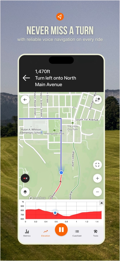
이 스크린샷은 상세한 턴바이턴 길 안내와 함께 실시간 고도 프로필을 제공하여 사용자가 경로를 벗어나지 않도록 돕습니다.
정확한 음성 안내
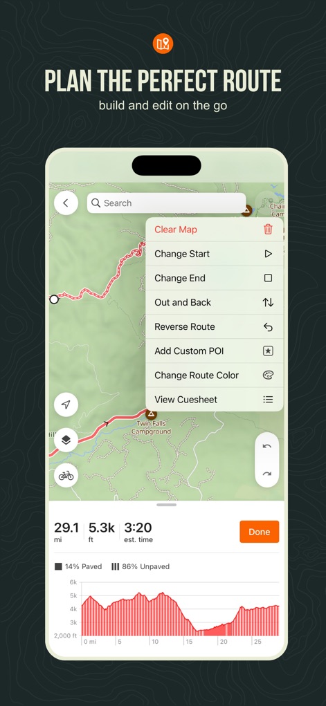
사용자는 경로 편집 옵션 메뉴를 활용하여 자신에게 맞는 경로를 만들 수 있으며, 경로의 포장 및 비포장 비율을 한눈에 확인할 수 있습니다.
나만의 경로 생성
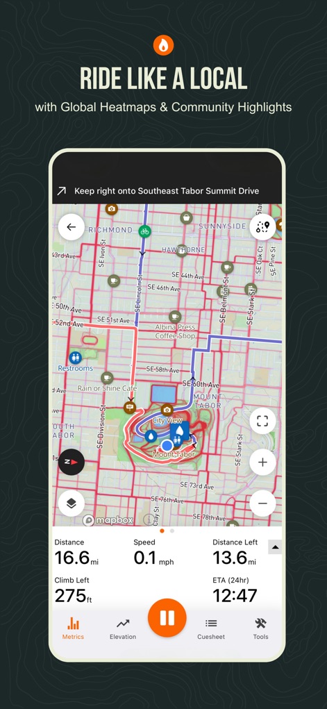
이 앱은 글로벌 히트맵 오버레이를 통해 인기 있는 지역 경로를 보여주며, 실시간 라이딩 메트릭스로 주행 상태를 상세히 파악할 수 있게 합니다.
현지인처럼 라이딩

서비스 불가지역에서도 사용자는 특정 지역을 선택하여 오프라인 지도를 다운로드할 수 있으며, 지도 크기와 포함된 경로 목록을 명확히 제시합니다.
오프라인 지도 지원
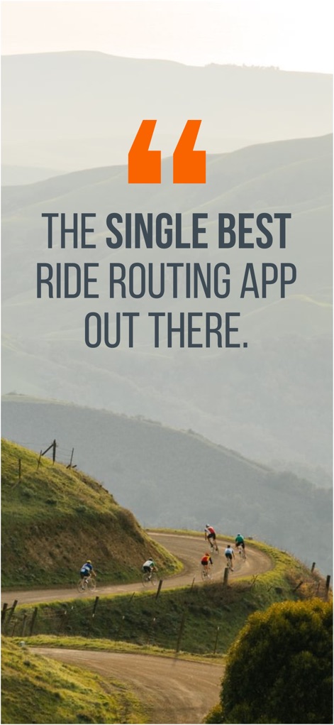
이 스크린샷은 "가장 뛰어난 라이딩 경로 앱"이라는 사용자 인용문을 강조하며, 구불구불한 도로를 달리는 여러 명의 자전거 라이더의 모습을 보여줍니다.
최고의 경로 앱
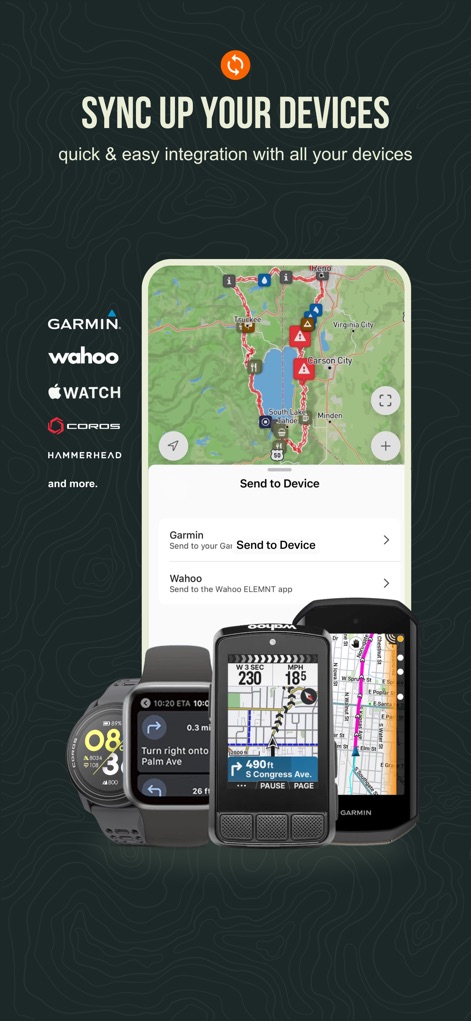
이 앱은 Garmin, Wahoo 등 유명 기기 브랜드와의 원활한 연동을 지원하며, '기기로 전송' 기능을 통해 라이딩 데이터를 손쉽게 공유할 수 있습니다.
다양한 기기 연동
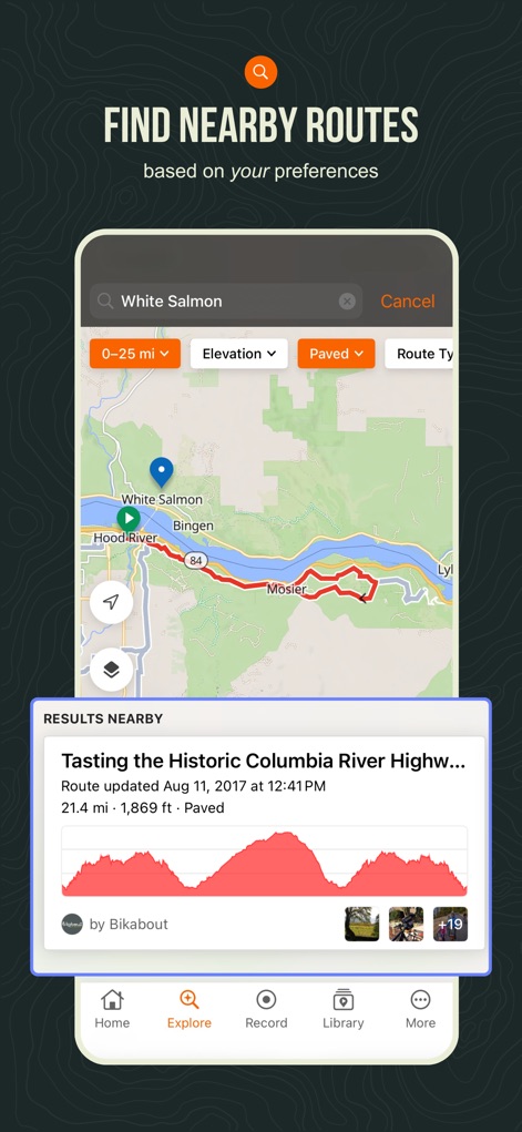
사용자는 거리, 고도, 포장 여부 등 세분화된 필터 옵션을 사용하여 주변 경로를 탐색할 수 있으며, 각 경로의 고도 프로필을 미리 확인할 수 있습니다.
주변 경로 탐색
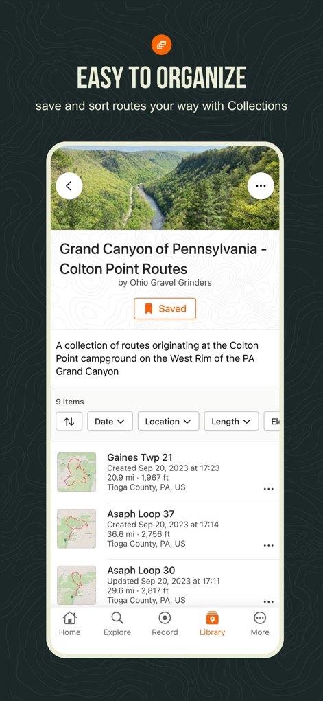
이 앱은 'Grand Canyon of Pennsylvania'와 같은 특정 경로 컬렉션을 제공하여 사용자가 쉽게 경로를 분류하고, 날짜, 위치, 길이 등 다양한 기준으로 정렬할 수 있게 합니다.
경로 컬렉션 관리
설명
Download
비슷한 앱
유사한 기능과 사용자 경험을 가진 앱

AllTrails: Hike, Bike & Run
AllTrails, Inc.

Pedometer++
Cross Forward Consulting, LLC

Organic Maps: Offline Map
Organic Maps OU

Gaia GPS: Mobile Trail Maps
Trailbehind, INC.

Offline hiking maps: Mapy.com
Seznam.cz a.s.

Hiking Map Poland
Mapa Turystyczna sp. z o.o.

MapOut
Valnova GmbH

FarOut: Offline GPS Trail Maps
Atlas Guides DE, Inc.

Norgeskart
Norgeskart AS
이 페이지는 앱이나 개발자의 공식 페이지가 아니며, 정보 제공 및 논평을 목적으로 작성된 독립 편집 간행물입니다. 명시적으로 달리 언급되지 않는 한, 해당 앱이나 개발자는 MWM, Apple, Google Play, 앱 퍼블리셔 또는 앱 개발자와 제휴, 보증, 후원, 승인 또는 공식적으로 연결되어 있지 않으며, 이 페이지의 어떤 내용도 해당 앱이 MWM의 서비스를 사용하여 개발되었음을 의미하지 않습니다. 모든 상표, 로고, 스크린샷 및 기타 콘텐츠는 해당 소유자의 자산입니다.