이 페이지는 앱이나 개발자의 공식 페이지가 아니며, 정보 제공 및 논평을 목적으로 작성된 독립 편집 간행물입니다. 명시적으로 달리 언급되지 않는 한, 해당 앱이나 개발자는 MWM, Apple, Google Play, 앱 퍼블리셔 또는 앱 개발자와 제휴, 보증, 후원, 승인 또는 공식적으로 연결되어 있지 않으며, 이 페이지의 어떤 내용도 해당 앱이 MWM의 서비스를 사용하여 개발되었음을 의미하지 않습니다. 모든 상표, 로고, 스크린샷 및 기타 콘텐츠는 해당 소유자의 자산입니다.
Sea Weather Professional
해안 항해자와 전문 선장을 위해 설계된 전문 등급의 해상 예보, NAVTEX 경고 및 필수 안전 도구로 요소를 마스터하세요. 해상에서 수 마일 떨어져 있을 때도 액세스할 수 있습니다.
진정한 항해사와 해상 전문가를 위해 설계된 전문 등급의 해상 날씨, 중요 안전 도구 및 안정적인 항해 데이터로 무장하세요.
정밀 해상 날씨 및 NAVTEX
대서양, 태평양 및 미국 연안을 위한 고해상도 바람 및 파도 예보, 기상 관측소 보고서 및 NAVTEX 무선 메시지에 액세스하세요.
고급 안전 및 앵커 모니터링
백그라운드 앵커 경보 및 음성 안내 MAYDAY 지원 및 SOS 신호 기능을 제공하는 조난 지원으로 선박 보안을 보장합니다.
다음 스크린샷과 설명은 앱의 공식 스토어 목록에서 직접 가져온 것이며 앱 개발자의 자산입니다.
앱 스토어
스크린샷
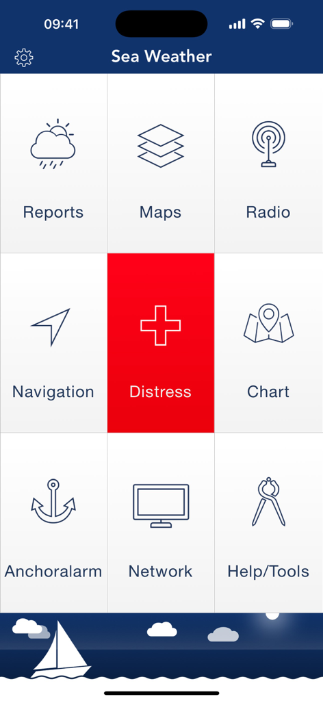
보고서, 지도 및 조난 경고와 같은 탐색 및 안전 도구를 보여주는 Sea Weather Professional 앱의 메인 대시보드.
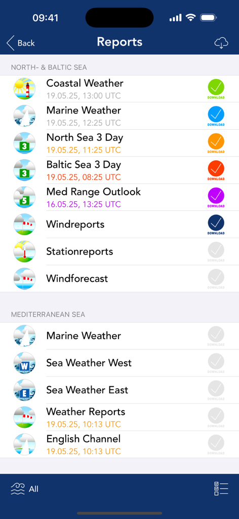
Sea Weather Professional 앱 인터페이스에서 북부 발트해 및 지중해의 해상 날씨 보고서 목록
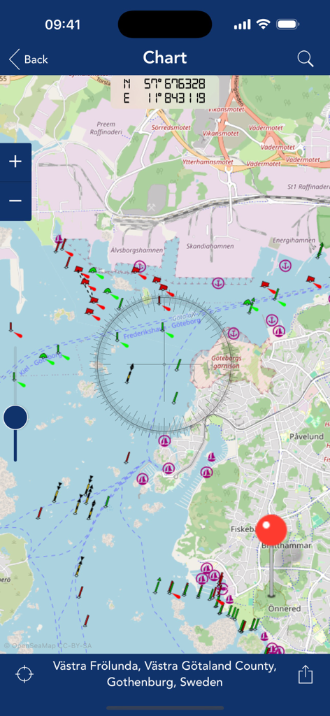
스웨덴 예테보리 근처의 항해 표시와 좌표를 보여주는 Sea Weather Professional 앱의 상세한 해도.
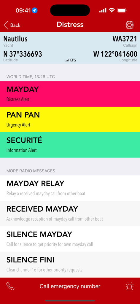
GPS 좌표가 포함된 Mayday 및 Pan Pan 옵션을 포함한 해상 조난 경고를 보여주는 모바일 화면
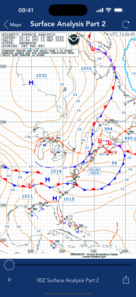
해상 항해를 위한 등압선 및 기압계를 보여주는 기술적인 대서양 표면 분석 일기 예보 지도
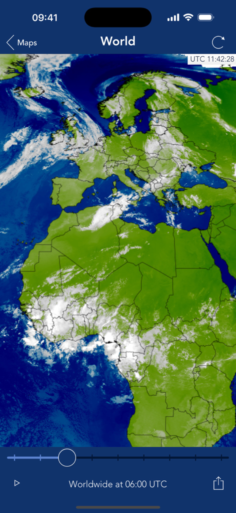
Sea Weather Professional 앱의 구름 덮개를 보여주는 전 세계 위성 일기 예보 지도
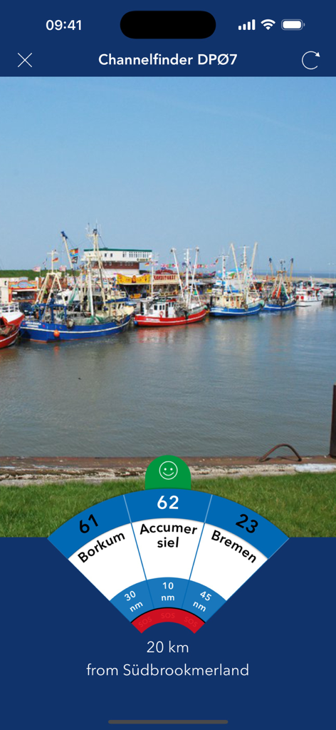
항구 사진을 통해 보르쿰과 브레멘의 해상 라디오 채널 및 거리를 보여주는 Channelfinder 기능이 있는 Sea Weather Professional 앱의 인터페이스
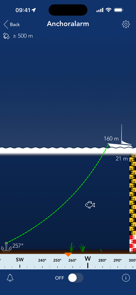
수심 및 거리 모니터링 데이터와 함께 보트 실루엣을 보여주는 Sea Weather Professional 앵커 경보 화면
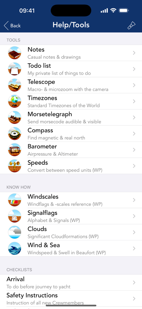
다양한 항해 도구, 참조 가이드 및 체크리스트를 보여주는 Sea Weather Professional 앱의 도움말 및 도구 메뉴.
설명
Sea Weather Professional provides nautical Information for the Atlantic, Pacific, North Sea, Baltic Sea and the Mediterranean Sea for professional planning and navigation. Open data from European & US weather services is enhanced for your mobile device.
Get weather reports, forecasts, maps, and NAVTEX radio messages from many nautical areas. Your One-stop-solution available for all devices (iPhone, iPad & iPod).
FEATURES:
– Marine weather reports and maps for Atlantic, Pacific, North Sea, Baltic Sea and Mediterranean Sea
– e.g. Coastal Weather Report, Shipping Forecast, Station reports, Wind Forecast, 3 Day Sea Weather Preview
– Wind & wave information for all three nautical areas
– NAVTEX radio messages
– Distress Assistant for calling MAYDAY / help & sending S O S
– Navigation Head Up Display
– OpenSeaMap the free nautical sea chart
– Checklists, Windcalculator, Nautical Signal Flags, Morsecodes, Clouds
– Sharing of reports and maps
– Offline Datastorage: Store reports, maps and other resources to access when offline
– Turbo Download: One-tap-update of all weather data (reports, maps, NAVTEX radio messages)
– Night vision: Red-Light-Vision ensures that your eyes keep night vision
– Anchor alarm: Monitor and log safety of your yacht position in background
– Waterlevels: Get access to the latest levels of inshore waterways
– European Reports: Get access to all kind of available marine weather info in Europe
– USA Reports: Reports & maps for United States Atlantic, Pacific & Alaska regions
– Todolist: Keep track of what needs to be done on board & proritize with colorful tags
– Telescope: Use the built in camera to magnify things far away
– Timezones: World Timezones for a lot of major cities
– Morse telegraph: Morse any message via audio or LED flashlight
– Compass: Easy to use compass whenever needed
– Barometer: Measure air pressure & keep history of measurements
– Distress-Voice-Assistant: In case of distress let the app speak for you
– Weatherinformation for cities worldwide
– Unlimited use of Seaweather Professional Nautical Network
– Frequent servicedata updates for the app
REPORTS & MAPS COVER FOLLOWING SEA AREAS:
Atlantic, Pacific, Alaska, East Frisian coast, estuary, Helgoland, North Frisian coast, the river Elbe between Hamburg and Cuxhaven, Flensburg to Fehmarn Fehmarn to the east of Rügen, east of Rügen, German Bight, Western Baltic Sea, Southern Baltic Sea, Southwest North Sea, fishing, Forties, Viking, Utsira, Skagerrak, Kattegat, the Belts and the Sound, Bodden East, South-eastern Baltic Sea, central Baltic Sea, Northern Baltic Sea, Gulf of Riga, Engl.Kanal-West-East Engl.Kanal, IJsselmeer, Canary Islands, Alborán / Gibraltar, Palos (between Spain and South West Algeria), Balearic Islands, west of Corsica / Sardinia, Gulf of Lions, Ligurian sea, Tyrrhenian sea, Adriatic Sea, Ionian Sea, Aegean Sea, Taurus, Biscay
SUBSCRIPTIONS:
The app offers a subsciption with the title "Nautical Club Membership" which is running for 1 year and will automatically be extended to another year after that. The 1-year subscription costs 11,99€. The standard Terms and Conditions (EULA) apply, see: https://www.apple.com/legal/internet-services/itunes/dev/stdeula/
Data Privacy Policy applies as follows:
https://www.noxymo.com/seewetterpro/privacy_de.html
ATTENTION:
– Use of anchoralarm product is only recommended under safe conditions (i.e. strong GPS signal)
– Continuous use of the Locationservices/GPS (e.g. using anchoralarm and navigational instruments) will drain the battery significantly faster than under normal conditions.
LICENSE:
Product uses icons from http://icons8.com/ under Creative Commons Attribution-NoDerivs 3.0 Unported License.
이 페이지는 앱이나 개발자의 공식 페이지가 아니며, 정보 제공 및 논평을 목적으로 작성된 독립 편집 간행물입니다. 명시적으로 달리 언급되지 않는 한, 해당 앱이나 개발자는 MWM, Apple, Google Play, 앱 퍼블리셔 또는 앱 개발자와 제휴, 보증, 후원, 승인 또는 공식적으로 연결되어 있지 않으며, 이 페이지의 어떤 내용도 해당 앱이 MWM의 서비스를 사용하여 개발되었음을 의미하지 않습니다. 모든 상표, 로고, 스크린샷 및 기타 콘텐츠는 해당 소유자의 자산입니다.