이 페이지는 앱이나 개발자의 공식 페이지가 아니며, 정보 제공 및 논평을 목적으로 작성된 독립 편집 간행물입니다. 명시적으로 달리 언급되지 않는 한, 해당 앱이나 개발자는 MWM, Apple, Google Play, 앱 퍼블리셔 또는 앱 개발자와 제휴, 보증, 후원, 승인 또는 공식적으로 연결되어 있지 않으며, 이 페이지의 어떤 내용도 해당 앱이 MWM의 서비스를 사용하여 개발되었음을 의미하지 않습니다. 모든 상표, 로고, 스크린샷 및 기타 콘텐츠는 해당 소유자의 자산입니다.

다운로드
1M+사용자 평점
총 평가 수
1.5K개발사
카테고리
Navigation지원 언어
4최신 버전
1.23.0크기
102.0 MB출시일
2020년 7월 22일스위스 아웃도어 활동을 위한 최고의 내비게이션 도구 평가
swisstopo 앱 핵심 기능 분석
무료 오프라인 지도
이 도구는 무료 오프라인 지도(1:25,000부터 1:100만)를 제공하여 인터넷 연결 없이도 스위스 전역에서 안정적인 탐색을 가능하게 합니다.
정밀한 스위스 국립 지도
이 앱은 1:10,000부터 1:100만까지 다양한 축척의 유명한 스위스 국립 지도를 제공하여 스위스의 가장 외딴 지역까지 탐색할 수 있게 해줍니다.
맞춤형 경로 계획 및 기록
사용자가 자신만의 경로를 그리고, 기록하고, 가져오고, 공유할 수 있으며, 하이킹, 사이클링, 산악 자전거 등 경로 유형과 개인 속도를 설정할 수 있습니다.
공식 테마 경로 정보
이 앱은 공식 하이킹, 산악 하이킹, 고산 하이킹 코스, 스노슈 및 스키 경로, 스위스 모빌리티 경로와 같은 특정 테마 경로 정보를 제공합니다.
전문 항공 및 드론 정보
이 도구는 항공 지도, 장애물, 공역 정보, 착륙장 및 드론 및 모델 항공기에 대한 제한 사항을 포함한 전문 항공 데이터를 제공합니다.
경로 안내 및 3D 파노라마 뷰
사용자가 도착 시간 및 남은 거리를 포함한 경로 안내와 함께 라벨링된 파노라마 및 3D로 경로를 볼 수 있는 파노라마 모드를 활용할 수 있습니다.
마커 및 메모 저장 기능
사용자가 지도에 마커를 저장하고, 메모를 추가하고, 이를 공유할 수 있어 중요한 지점이나 발견 사항을 기록하고 공유하는 데 유용합니다.
지리 데이터 검색 및 측정 도구
이 앱은 측정, 비교, 지리적 이름, 주소 또는 좌표 검색과 같은 유용한 도구를 포함하여 지리 데이터 탐색을 용이하게 합니다.
대중교통 정류장 정보
이 앱은 대중교통 정류장 위치 정보를 제공하여 대중교통을 이용한 접근 및 이동 계획을 지원합니다.
지도 및 데이터 변경 보고
이 도구는 사용자가 지도 및 지리 데이터의 변경 사항을 보고할 수 있는 기능을 제공하여 정보의 정확성과 최신성을 유지하는 데 기여합니다.
자주 묻는 질문
에 대해 알아야 할 모든 것 swisstopo
Has the swisstopo app received any awards?
Yes, the swisstopo app won the "Master of Swiss Apps 2021" award, recognizing its quality and functionality.
Is the swisstopo app free to use?
Yes, all functions, data, and offline use of the swisstopo app are completely free of charge.
Does the swisstopo app require a login or display ads?
No, the swisstopo app is free of advertising and does not require users to create an account or log in.
What map scales are available in the swisstopo app?
The swisstopo app offers comprehensive national maps covering all scales from 1:10,000 to 1:1 million.
Does the swisstopo app include historical maps?
Yes, the swisstopo app provides current aerial images and historical maps, enhancing navigation and exploration.
What outdoor activity routes does the swisstopo app offer?
The swisstopo app includes official hiking, mountain hiking, alpine hiking trails, snowshoe routes, and ski routes.
Does the swisstopo app show hiking trail closures?
Yes, the swisstopo app displays current information regarding closures of hiking trails.
Can swisstopo app maps be used offline?
Yes, the swisstopo app offers free offline maps, available in scales from 1:25,000 to 1:1 million.
How do I plan and manage tours with the swisstopo app?
The swisstopo app allows users to draw, record, import, and share their own tours. Users can set tour type and personal pace.
Does the swisstopo app have a panorama mode?
Yes, the swisstopo app features a panorama mode with labelled views and the ability to view tours in 3D.
What search and measurement tools are available in the swisstopo app?
The swisstopo app provides tools for measuring, comparing, and searching geographical names, addresses, or coordinates.
What aviation-specific features does the swisstopo app offer?
The swisstopo app includes aeronautical charts, obstacles, airspaces, landing sites, and restrictions for drones and model aircrafts.
How can I get support for the swisstopo app?
Users can contact support for the swisstopo app by sending an email to support-cd@swisstopo.ch.
다음 스크린샷과 설명은 앱의 공식 스토어 목록에서 직접 가져온 것이며 앱 개발자의 자산입니다.
앱 스토어
스크린샷
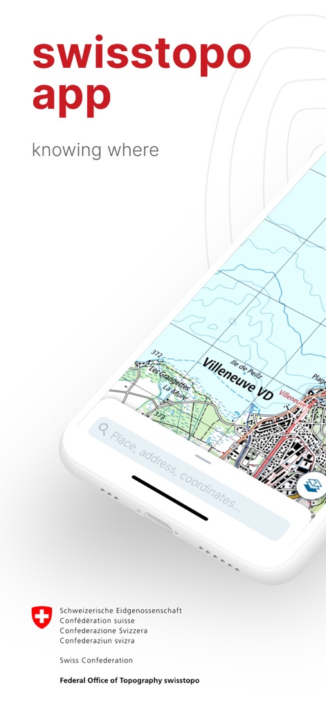
이 앱은 사용자에게 스위스의 상세한 국토 지도를 제공하며, 화면 하단의 검색창과 중앙에 위치한 빌뇌브(Villeneuve VD) 지역의 지형 정보가 명확하게 보입니다.
스위스 정밀 지도
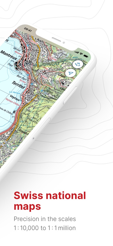
이 앱은 1:10,000에서 1:1백만까지 다양한 축척의 스위스 국립 지도를 자랑하며, 몽트뢰(Montreux) 지역의 상세한 등고선과 도로망을 확인할 수 있습니다.
정확한 스위스 지형

사용자는 항공 차트, 항공 사진, 역사 지도 등 다양한 주제의 지도를 선택하여 볼 수 있으며, 'Aviation' 탭이 활성화되어 있고 배경 이미지로 여러 유형의 지도가 미리 보입니다.
다채로운 지도 주제

이 앱의 파노라마 모드는 주변 산의 이름과 고도(예: 마터호른 4478, 돔 4546)를 표시하여, 사용자가 실제 풍경과 일치하는 정보를 얻을 수 있도록 돕습니다.
생생한 파노라마 시야

사용자는 지도 위에 경로를 쉽게 계획하고 안내를 받을 수 있으며, 도착 시간(1시간 51분)과 남은 거리(5.8km)를 포함한 상세한 경로 정보가 하단에 표시됩니다.
쉬운 경로 계획

이 앱은 오프라인 지도 기능을 제공하여 사용자가 인터넷 연결 없이도 준비된 지도를 활용할 수 있게 하며, 'La Punt' 지역의 다운로드 가능한 지도 용량(약 13.2MB)과 면적(21.3km²)이 명시되어 있습니다.
오프라인 지도 활용
설명
Download
비슷한 앱
유사한 기능과 사용자 경험을 가진 앱

AllTrails: Hike, Bike & Run
AllTrails, Inc.

Pedometer++
Cross Forward Consulting, LLC

Organic Maps: Offline Map
Organic Maps OU

Gaia GPS: Mobile Trail Maps
Trailbehind, INC.

Offline hiking maps: Mapy.com
Seznam.cz a.s.

Hiking Map Poland
Mapa Turystyczna sp. z o.o.

MapOut
Valnova GmbH

FarOut: Offline GPS Trail Maps
Atlas Guides DE, Inc.

Norgeskart
Norgeskart AS
이 페이지는 앱이나 개발자의 공식 페이지가 아니며, 정보 제공 및 논평을 목적으로 작성된 독립 편집 간행물입니다. 명시적으로 달리 언급되지 않는 한, 해당 앱이나 개발자는 MWM, Apple, Google Play, 앱 퍼블리셔 또는 앱 개발자와 제휴, 보증, 후원, 승인 또는 공식적으로 연결되어 있지 않으며, 이 페이지의 어떤 내용도 해당 앱이 MWM의 서비스를 사용하여 개발되었음을 의미하지 않습니다. 모든 상표, 로고, 스크린샷 및 기타 콘텐츠는 해당 소유자의 자산입니다.