이 페이지는 앱이나 개발자의 공식 페이지가 아니며, 정보 제공 및 논평을 목적으로 작성된 독립 편집 간행물입니다. 명시적으로 달리 언급되지 않는 한, 해당 앱이나 개발자는 MWM, Apple, Google Play, 앱 퍼블리셔 또는 앱 개발자와 제휴, 보증, 후원, 승인 또는 공식적으로 연결되어 있지 않으며, 이 페이지의 어떤 내용도 해당 앱이 MWM의 서비스를 사용하여 개발되었음을 의미하지 않습니다. 모든 상표, 로고, 스크린샷 및 기타 콘텐츠는 해당 소유자의 자산입니다.

TroutRoutes: Fly Fishing App
다음 낚시 여행을 계산된 모험으로 바꾸세요. 50,000개 이상의 지도에 표시된 하천, 확실한 공공 토지 경계, 실시간 유량 데이터에 액세스하여 절대적인 자신감으로 낚시하세요.
다운로드
726K+사용자 평점
총 평가 수
3K+개발사
카테고리
Navigation지원 언어
1최신 버전
5.3.5크기
282.9 MB출시일
2019년 3월 4일모든 낚시꾼을 위한 궁극의 전술적 이점
정밀도, 법적 접근 권한 및 실시간 하천 정보를 위해 제작된 업계 최고의 매핑 도구를 사용하여 조사 시간을 줄이고 낚시 시간을 늘리세요.
공공 접근 권한 마스터
색상으로 구분된 공공 및 사유지 경계를 사용하여 통행권 및 무단 침입 방지를 통해 완벽한 마음의 평화로 낚시하세요.
실시간 하천 정보
선택한 목적지가 최고의 낚시 조건을 갖추고 있는지 확인하기 위해 USGS 실시간 유량 데이터 및 수위 차트를 통해 미리 알고 가세요.
자주 묻는 질문
에 대해 알아야 할 모든 것 TroutRoutes: Fly Fishing App
onX의 TroutRoutes는 무엇인가요?
onX의 TroutRoutes는 송어 낚시를 위한 최고의 GPS 매핑 도구로, 미국 본토 50,000개 이상의 송어 하천에 대한 대화형 지도, 하천 데이터 및 내비게이션 기능을 제공합니다.
TroutRoutes는 낚시 장소를 찾는 데 도움이 되나요?
네, TroutRoutes는 독자적인 매핑 시스템을 통해 사용자가 지역 낚시 장소를 찾고 새로운 물가를 탐험할 수 있도록 도와주며, 트레일 접근, 주차, 공공 접근 지점과 같은 세부 정보를 제공합니다.
TroutRoutes에는 몇 개의 송어 하천이 매핑되어 있나요?
TroutRoutes는 미국 본토 48개 주에 걸쳐 50,000개 이상의 송어 하천을 매핑합니다. 각 하천 및 강에 대한 서식지 품질을 포함한 포괄적인 정보를 제공합니다.
TroutRoutes를 오프라인으로 사용할 수 있나요?
네, TroutRoutes는 사용자가 강 또는 지역별로 상세 지도를 다운로드하여 오프라인으로 사용할 수 있도록 허용합니다. 이 기능을 통해 휴대폰 서비스 없이도 작동하며, 사용자는 사용자 지정 마크업을 저장할 수 있습니다.
TroutRoutes는 실시간 하천 상태를 보여주나요?
네, TroutRoutes는 실시간 하천 상태를 제공합니다. 하천 계측기의 실시간 데이터를 사용하여 유량, 하천 높이 및 수온을 표시하여 정보에 입각한 낚시 결정을 내릴 수 있도록 합니다.
TroutRoutes PRO 멤버십 비용은 얼마인가요?
TroutRoutes PRO 멤버십은 연간 58.99달러입니다. 이 플랜에는 48개 주 전체, 50,000개의 분류된 송어 하천, 280,000개의 사용자 지정 접근 지점에 대한 모든 기능 액세스가 포함됩니다.
TroutRoutes 무료 체험판이 있나요?
네, TroutRoutes는 앱 설치 시 7일간 무료 PRO 체험판을 제공합니다. 이 체험판은 공공 토지 구획, 분류된 송어 하천, 사용자 지정 접근 지점 및 오프라인 지도를 잠금 해제합니다.
TroutRoutes로 플라이 낚시 샵으로 가는 길을 안내받을 수 있나요?
네, TroutRoutes는 사용자가 지역 플라이 낚시 샵을 찾는 데 도움을 줍니다. 이 앱은 샵 위치, 웹사이트 바로 가기, 편의를 위한 내비게이션 경로를 제공합니다.
TroutRoutes는 낚시 규정에 대한 정보를 제공하나요?
네, TroutRoutes는 각 주에 대한 색상으로 구분된 낚시 규정 섹션이 있는 규정 지도를 포함합니다. 준수를 보장하기 위해 상세한 강 규정을 제공합니다.
TroutRoutes는 어떤 종류의 접근 지점을 식별하나요?
TroutRoutes는 낚시 통행권, 국유림, 지역 공원, 보트 램프를 포함한 다양한 접근 지점을 식별합니다. 280,000개 이상의 수작업으로 큐레이션된 공공 접근 지점을 특징으로 합니다.
TroutRoutes에서 사용자 지정 관심 지점을 표시할 수 있나요?
네, TroutRoutes는 사용자가 사용자 지정 지도를 만들 수 있도록 합니다. 사용자는 여행 계획 및 추적을 향상시키기 위해 관심 지점에 대한 개인 마크업 및 메모를 추가할 수 있습니다.
TroutRoutes는 단일 주 멤버십을 제공하나요?
네, TroutRoutes는 연간 19.99달러의 단일 주 멤버십을 제공합니다. 이 플랜은 선택한 주에 대해 분류된 송어 하천 및 사용자 지정 접근 지점과 같은 모든 PRO 기능에 액세스할 수 있습니다.
다음 스크린샷과 설명은 앱의 공식 스토어 목록에서 직접 가져온 것이며 앱 개발자의 자산입니다.
앱 스토어
스크린샷
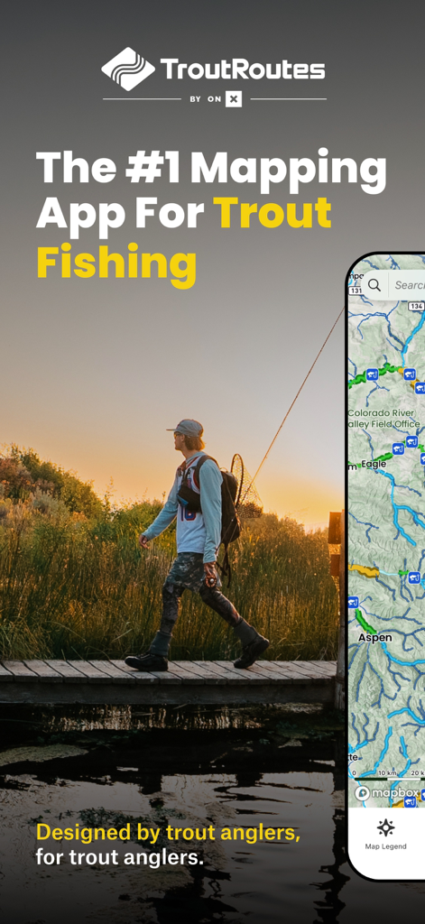
스마트폰에 TroutRoutes 낚시 지도 앱이 표시된 일몰 다리를 건너는 플라이 낚시꾼의 모습
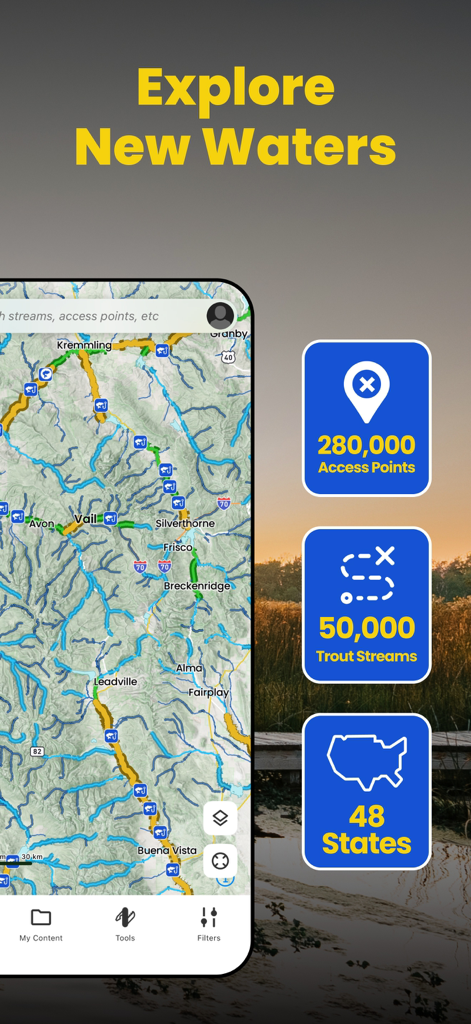
송어 낚시터와 접근 지점 지도를 보여주는 TroutRoutes 앱 인터페이스.
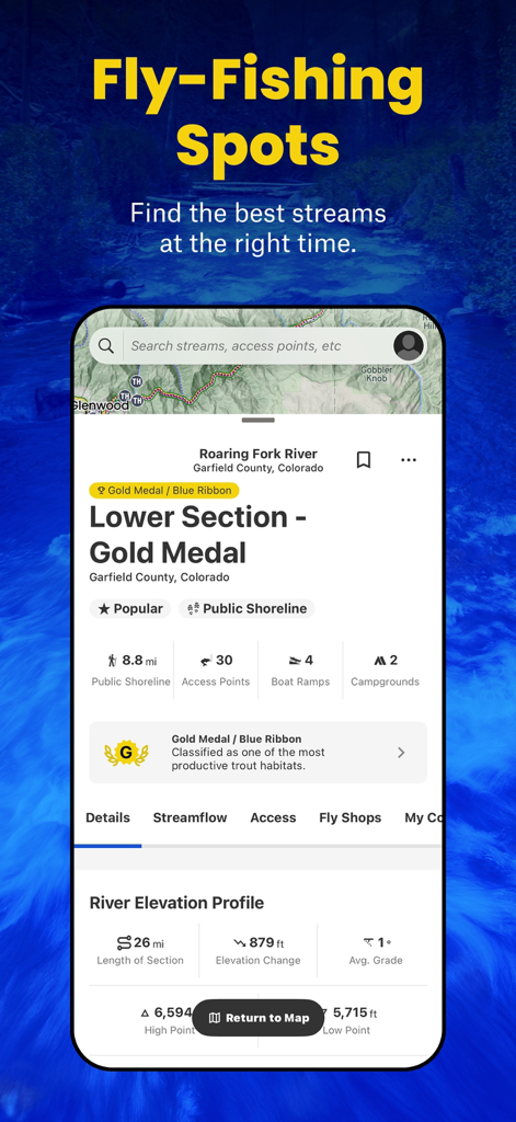
콜로라도의 Roaring Fork River에 대한 낚시터와 상세 데이터를 보여주는 TroutRoutes 앱 인터페이스
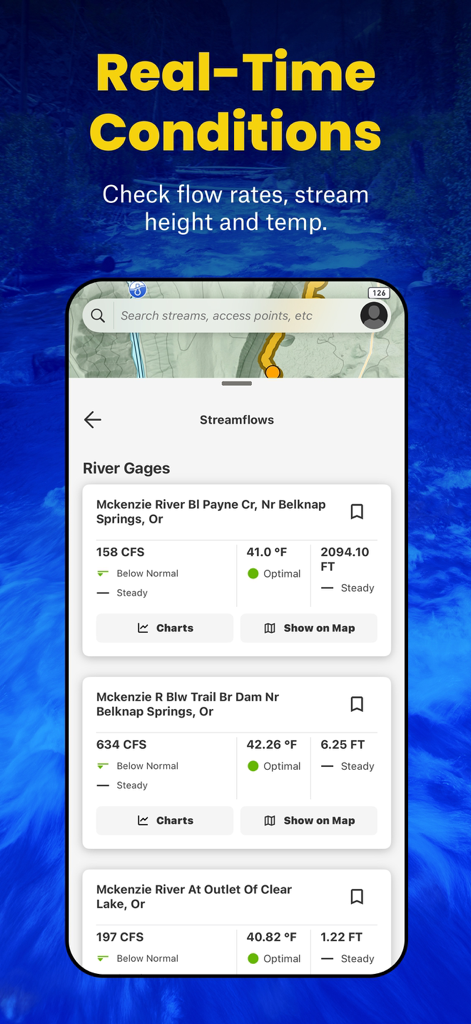
유량, 수온 및 하천 높이를 포함한 실시간 하천 조건을 보여주는 TroutRoutes 앱 인터페이스
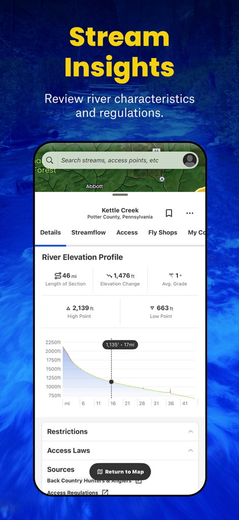
플라이 낚시 계획을 위한 하천 고도 프로필 및 하천 특성을 보여주는 TroutRoutes 앱 디스플레이.
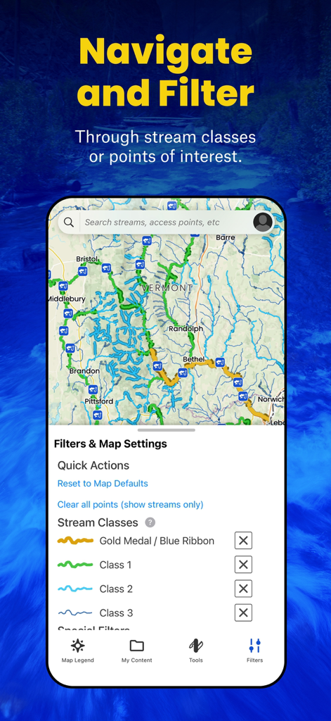
버몬트 송어 낚시터의 지형도 및 하천 등급 필터를 표시하는 TroutRoutes 앱 인터페이스
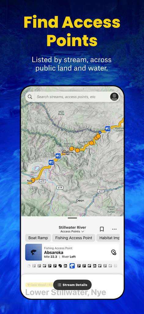
Stillwater River에 대한 낚시 접근 지점 및 하천 데이터가 포함된 지도을 표시하는 TroutRoutes 앱 스크린샷
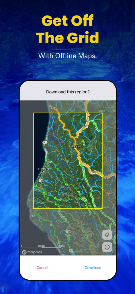
송어 낚시터의 오프라인 지도 다운로드를 위한 TroutRoutes 앱 인터페이스를 보여주는 스마트폰 화면

사용자 지정 지도 경유지 및 낚시터를 설정하기 위한 TroutRoutes 앱 인터페이스
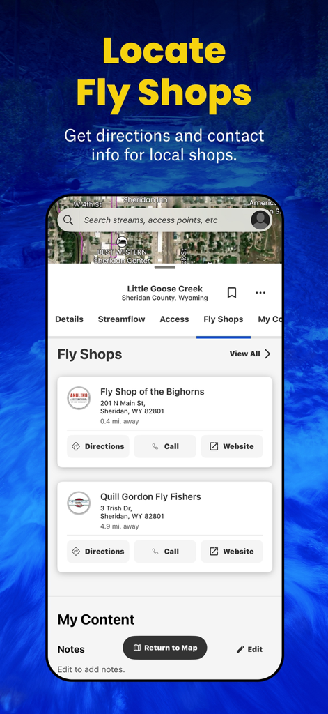
연락처 정보 및 길찾기가 포함된 지역 플라이 샵을 표시하는 TroutRoutes 앱 인터페이스
설명
Download
비슷한 앱
유사한 기능과 사용자 경험을 가진 앱

FishAngler - Fish Finder App
FishAngler, LLC

钓鱼天气预报
Hefei Sasha Technology Co., Ltd.

潮汐表-潮汐天气预报&钓鱼潮汐天气工具助手
荣虎 太

Fishbrain - Fishing App
FishBrain AB

Fishing Points: Map & Forecast
Fishing Points d.o.o.

onX Fish: Midwest Lake Finder
onXmaps, Inc.

Fishbox - Smart Fishing App
MEMS Group, Inc.

釣果記録FishRanker-フィッシュランカー,釣り,分析
SIIG Inc.

Fish Deeper - Fishing App
Deeper UAB
이 페이지는 앱이나 개발자의 공식 페이지가 아니며, 정보 제공 및 논평을 목적으로 작성된 독립 편집 간행물입니다. 명시적으로 달리 언급되지 않는 한, 해당 앱이나 개발자는 MWM, Apple, Google Play, 앱 퍼블리셔 또는 앱 개발자와 제휴, 보증, 후원, 승인 또는 공식적으로 연결되어 있지 않으며, 이 페이지의 어떤 내용도 해당 앱이 MWM의 서비스를 사용하여 개발되었음을 의미하지 않습니다. 모든 상표, 로고, 스크린샷 및 기타 콘텐츠는 해당 소유자의 자산입니다.