이 페이지는 앱이나 개발자의 공식 페이지가 아니며, 정보 제공 및 논평을 목적으로 작성된 독립 편집 간행물입니다. 명시적으로 달리 언급되지 않는 한, 해당 앱이나 개발자는 MWM, Apple, Google Play, 앱 퍼블리셔 또는 앱 개발자와 제휴, 보증, 후원, 승인 또는 공식적으로 연결되어 있지 않으며, 이 페이지의 어떤 내용도 해당 앱이 MWM의 서비스를 사용하여 개발되었음을 의미하지 않습니다. 모든 상표, 로고, 스크린샷 및 기타 콘텐츠는 해당 소유자의 자산입니다.

指南针-经纬度定位海拔运动轨迹
이 앱은 사용자에게 평범한 지리 정보를 넘어선 통찰력을 부여합니다. 당신의 위치를 단순한 좌표가 아닌, 환경과의 깊은 연결로 전환합니다.
다운로드
500k+사용자 평점
총 평가 수
3.4K개발사
카테고리
Travel지원 언어
1최신 버전
1.5크기
24.7 MB출시일
2024년 9월 30일야외 활동 애호가를 위한 정밀 위치 및 환경 정보 도구 평가
앱 '指南针-经纬度定位海拔运动轨迹' 기술 분석
실시간 GPS 위치 확인
이 앱은 GPS를 통해 사용자의 현재 위치(경위도, 고도)를 실시간으로 파악할 수 있게 해줍니다.
정밀 디지털 나침반
이 도구는 휴대폰 센서를 활용하여 사용자의 정확한 방향을 실시간으로 안내합니다.
실시간 해발 고도 표시
이 앱은 현재 위치의 해발 고도를 실시간으로 정확하게 표시하여 고도 정보를 제공합니다.
정교한 운동 궤적 기록
이 기능은 사용자의 이동 경로를 상세하게 기록하고 통계를 제공하여 활동 기록을 체계적으로 관리할 수 있도록 돕습니다.
24시간 실시간 날씨 정보
이 앱은 실시간으로 날씨 변화를 모니터링하고 24시간 동안의 정확한 일기 예보를 제공합니다.
위치 정보 워터마크 카메라
이 도구는 사진 촬영 시 자동으로 경위도 및 날씨 정보를 이미지에 추가하여 위치 기반 기록을 풍부하게 만듭니다.
자주 묻는 질문
에 대해 알아야 할 모든 것 指南针-经纬度定位海拔运动轨迹
What is the "指南针" app?
The "指南针" app is a professional positioning tool. It uses network, GPS, and phone sensors to determine latitude, longitude, and altitude, offering real-time GPS information, speed measurement, and elevation data.
Does the "指南针" app include a compass feature?
Yes, the "指南针" app includes a compass feature. It utilizes the phone's sensors to provide users with real-time orientation information accurately.
Can the "指南针" app record motion tracks?
Yes, the "指南针" app can record motion tracks. It statistically analyzes and saves users' movement trajectories over a period of time.
What is the watermark camera feature in the "指南针" app?
The "指南针" app's watermark camera automatically adds essential information to photos. This includes geographical coordinates (latitude and longitude) and real-time weather details.
Does the "指南针" app provide weather information?
Yes, the "指南针" app provides weather information. It offers real-time monitoring of weather changes and delivers accurate 24-hour weather forecasts.
How does "指南针" app acquire location data?
The "指南针" app acquires location data by utilizing network, GPS, and phone sensors. It supports real-time display of GPS information, GPS speed, and altitude.
Where can users find the privacy policy for the "指南针" app?
Users can find the privacy policy for the "指南针" app at the provided URL: https://docs.qq.com/doc/p/4c2af06c15fcf0b1a7e9f531e0dbba9a660bc111.
다음 스크린샷과 설명은 앱의 공식 스토어 목록에서 직접 가져온 것이며 앱 개발자의 자산입니다.
앱 스토어
스크린샷
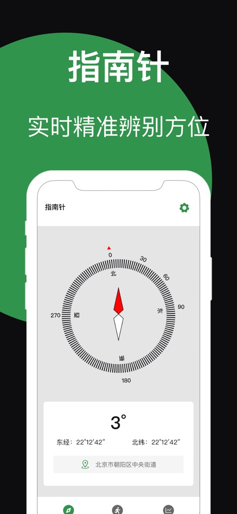
이 앱은 실시간 나침반 기능으로 사용자의 현재 방위를 정확히 알려주며(나침반 바늘), 현재 위치의 경도 및 위도 정보를 명확하게 표시합니다(22°12'42").
정확한 나침반

사용자는 이 도구를 통해 이동 경로를 지도 위에 실시간으로 기록할 수 있으며(지도상의 궤적), 이동 거리(0.0km)와 현재 속도(0km/h) 같은 핵심 운동 데이터를 상세하게 파악할 수 있습니다.
운동 궤적 기록
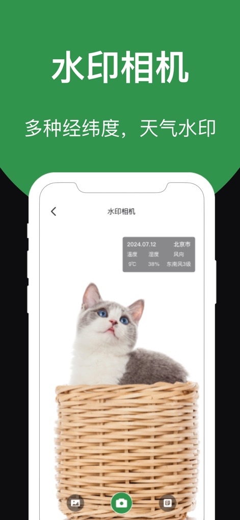
이 앱의 워터마크 카메라 기능을 활용하여 촬영된 이미지에 현재 위치의 날짜(2024.07.12)와 기온 정보(9℃)를 자동으로 추가할 수 있으며, 사진과 함께 특정 순간의 날씨 데이터까지 기록하여 추억을 더욱 풍부하게 만듭니다.
워터마크 카메라
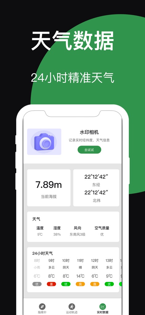
사용자는 현재 고도(7.89m)와 정확한 경도 및 위도 정보(22°12'42")를 한눈에 확인할 수 있으며, 현재 날씨 상황과 24시간 예보를 포함한 모든 중요한 환경 데이터를 통합적으로 파악할 수 있습니다.
종합 데이터 확인
설명
Download
비슷한 앱
유사한 기능과 사용자 경험을 가진 앱

Realtime Altimeter
Zhenlai Xia

Travel Camera & Compass
Ha Nguyen

compass-latitude and longitude
美霞 熊

Compass ×
DOUBLE U s.r.o.

GPS Altitude-海拔表
祥琦 孔

Compass: GPS & Altimeter
Shanghai BRC Internet Technology Co., Ltd.

Compass - GPS positioning
嘉 罗

Compass360X-GPS Speedometer
卫豪 吴

指南针-GPS经纬度海拔定位
Chongqing Xinzhi Space Technology Co., Ltd.
이 페이지는 앱이나 개발자의 공식 페이지가 아니며, 정보 제공 및 논평을 목적으로 작성된 독립 편집 간행물입니다. 명시적으로 달리 언급되지 않는 한, 해당 앱이나 개발자는 MWM, Apple, Google Play, 앱 퍼블리셔 또는 앱 개발자와 제휴, 보증, 후원, 승인 또는 공식적으로 연결되어 있지 않으며, 이 페이지의 어떤 내용도 해당 앱이 MWM의 서비스를 사용하여 개발되었음을 의미하지 않습니다. 모든 상표, 로고, 스크린샷 및 기타 콘텐츠는 해당 소유자의 자산입니다.