This page is not an official page of the app or its developer, but an independent editorial publication created for informational and commentary purposes. Unless expressly stated otherwise, neither the app nor its developer is affiliated with, endorsed by, sponsored by, authorized by, or otherwise officially connected with MWM, Apple, Google Play, the app publisher, or the app's developer, and nothing on this page implies that the app was developed using MWM's services. Any trademarks, logos, screenshots, and other content remain the property of their respective owners.

AR AlpineGuide
Turn your smartphone into a professional mountain guide. Instantly discover names, altitudes, and distances for over one million summits worldwide with precision 3D terrain mapping.
Downloads
933K+User Rating
Total Ratings
9K+Publisher
Category
NavigationLocales
11Latest Version
4.60.0Size
140.2 MBFirst Released
Mar 10, 2016Unlock the Secrets of the Skyline
Experience the world's most advanced AR mountain guide. From casual hikes to serious mountaineering, get instant data on over one million peaks across the globe for free.
Instant Peak Recognition
Simply point your device to see the names, altitudes, and distances of every mountain peak in a stunning AR panoramic view.
3D Terrain Intelligence
Match the horizon perfectly with semi-transparent 3D overlays or tilt down for a satellite-style bird’s-eye perspective.
Frequently Asked Questions
Everything you need to know about AR AlpineGuide
What is AR AlpineGuide?
AR AlpineGuide is an iOS app that identifies mountain names, altitudes, and distances by pointing your device camera at mountains. It offers a 360-degree panoramic augmented reality view of peaks.
Is AR AlpineGuide free to use?
Yes, AR AlpineGuide is free to use. All its features are available without charge.
How many mountain peaks does AR AlpineGuide include?
AR AlpineGuide includes data for nearly one million peaks from around the world. This extensive database allows for widespread mountain identification.
Can AR AlpineGuide identify mountains in a 360-degree view?
Yes, AR AlpineGuide identifies the names of all mountain peaks in a 360-degree panoramic augmented reality (AR) view.
Does AR AlpineGuide work if the iOS device camera is tilted?
Yes, AR AlpineGuide uses three-dimensional coordinates and a gyroscope to display peak names accurately even if the iOS device camera is tilted.
Can users add peak names to existing photos using AR AlpineGuide?
Yes, AR AlpineGuide allows users to import photos taken with another app and add the peak names to them.
Can AR AlpineGuide be used offline?
Yes, AR AlpineGuide can be used offline. This feature allows mountain identification without an internet connection.
How does AR AlpineGuide handle incorrect direction display?
If AR AlpineGuide displays an incorrect direction, users should remove any iOS device cover. Metal or magnets in the cover can interfere with the sensor, causing malfunctions.
Can I adjust the peak name display position in AR AlpineGuide?
Yes, AR AlpineGuide allows users to adjust the position of the peak name display by swiping the AR display. This adjustment is also possible after taking a picture.
Does AR AlpineGuide display 3D terrain?
Yes, AR AlpineGuide displays the three-dimensional terrain semi-transparently. This feature aids in comparing it with the actual mountain shape and confirming peak locations.
Can AR AlpineGuide view landscapes from a specified map location?
Yes, AR AlpineGuide allows users to check the names of terrain and mountains visible from any location specified on the map.
The following screenshots and description are sourced directly from the app's official store listing and are the property of the app developer.
App Store
Screenshots
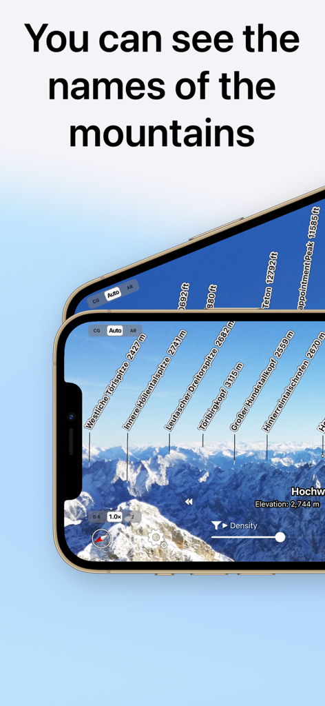
AR AlpineGuide app showing augmented reality mountain peak names and altitudes on a smartphone screen
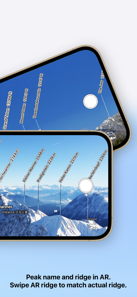
AR AlpineGuide app identifying mountain peaks and altitudes through an augmented reality camera view.
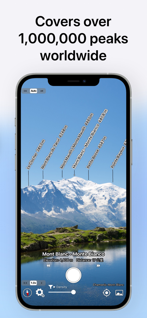
AR AlpineGuide app screen showing augmented reality peak labels over the Mont Blanc mountain range
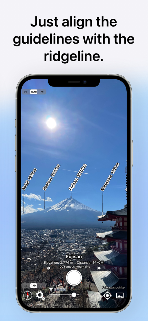
AR AlpineGuide app interface showing augmented reality labels for mountain peaks and altitudes on Mount Fuji
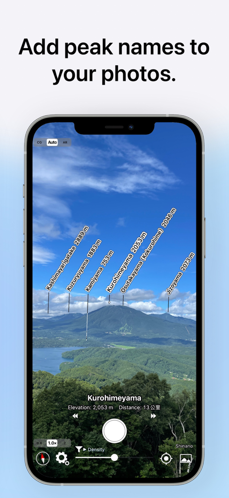
AR AlpineGuide app identifying mountain peaks with names and altitudes on a photo
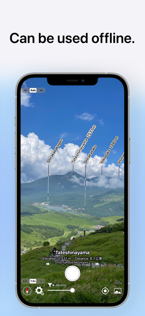
AR AlpineGuide app interface showing mountain peaks labeled with names and elevations in an augmented reality view with an offline mode caption.
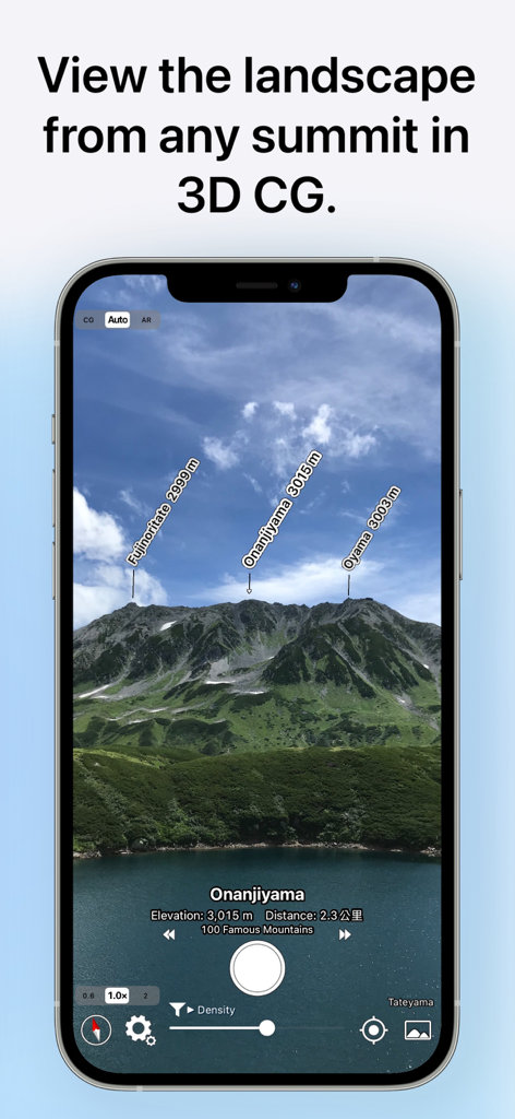
AR AlpineGuide app screenshot showing labeled mountain peaks with their names and altitudes in a 3D view
Description
Download
More Like This
Apps with similar features and user experience


This page is not an official page of the app or its developer, but an independent editorial publication created for informational and commentary purposes. Unless expressly stated otherwise, neither the app nor its developer is affiliated with, endorsed by, sponsored by, authorized by, or otherwise officially connected with MWM, Apple, Google Play, the app publisher, or the app's developer, and nothing on this page implies that the app was developed using MWM's services. Any trademarks, logos, screenshots, and other content remain the property of their respective owners.