This page is not an official page of the app or its developer, but an independent editorial publication created for informational and commentary purposes. Unless expressly stated otherwise, neither the app nor its developer is affiliated with, endorsed by, sponsored by, authorized by, or otherwise officially connected with MWM, Apple, Google Play, the app publisher, or the app's developer, and nothing on this page implies that the app was developed using MWM's services. Any trademarks, logos, screenshots, and other content remain the property of their respective owners.

Hiking Maps - PeakVisor
The ultimate visual toolkit for explorers. Identify over a million peaks, navigate with cutting-edge 3D terrain modeling, and track your hiking or skiing adventures with professional-grade GPS—all available offline.
Downloads
2M+User Rating
Total Ratings
62K+Publisher
Category
TravelLocales
14Latest Version
5.73Size
150.6 MBFirst Released
Dec 21, 2016Master Every Summit with Cutting-Edge Tools
PeakVisor transforms your phone into a high-precision navigation system, blending Augmented Reality and 3D terrain modeling to enhance every mountain adventure.
Instant Peak Identification
Point your camera to identify over a million peaks instantly. Get names, elevations, and detailed terrain data even without cell service.
High-Precision 3D Maps
Navigate with confidence using future-gen topo maps. Visualize trail steepness and terrain nuances in a fully immersive 3D world.
Frequently Asked Questions
Everything you need to know about Hiking Maps - PeakVisor
What is PeakVisor?
PeakVisor is a mountain navigation app providing state-of-the-art Peak Identification, 3D Maps, Trails, and outdoor GPS tracking. It is designed for activities like hiking, skiing, and climbing, offering a detailed 3D mountain experience.
Does PeakVisor use augmented reality for peak identification?
Yes, PeakVisor uses augmented reality (AR) technology. It overlays names and elevations of nearby peaks directly onto your iPhone's camera view for real-time identification.
How many mountains can PeakVisor identify?
PeakVisor can identify over a million mountains, hills, buttes, and spires globally. It provides detailed profiles including altitude, topographic prominence, mountain range, and additional Wikipedia articles.
Can I plan hiking routes using PeakVisor?
Yes, PeakVisor enables planning hiking routes with its 3D Maps and vast trail network. It helps evaluate expected distance, elevation profiles, and estimated completion times for your adventure.
What skiing features does PeakVisor offer?
PeakVisor offers topographic 3D Maps for skiing, detailing mountain lifts, ski resort trails, and backcountry routes. It also includes a winter mode and slope steepness overlay for avalanche terrain identification.
Does PeakVisor show cable car and mountain hut information?
Yes, PeakVisor's 3D Maps include cable cars and mountain huts, complete with their schedules. This feature assists in planning mountain objectives, especially in European regions.
Can PeakVisor track my outdoor activities?
Yes, PeakVisor provides GPS Tracking for outdoor adventures like hiking, skiing, and mountain biking. You can visualize your route in 3D, view stats like distance and elevation gain, and export GPX files.
Is PeakVisor functional without an internet connection?
Yes, all features of PeakVisor work offline. Users can download topographic map data for regions like the Alps to ensure full functionality without requiring an internet connection.
How can I access all PeakVisor features without limitations?
Users can access all PeakVisor features without limitations by subscribing to PeakVisor PRO. This premium subscription is available on a monthly or annual basis.
Does the PeakVisor app display advertisements?
No, the PeakVisor app does not display any advertisements. All revenue generated by the app comes from user subscriptions to PeakVisor PRO.
Can I tag mountains in my photos using PeakVisor?
Yes, PeakVisor allows you to tag mountains in your photos using its AR technology. You can overlay peak names and altitudes onto your images and save them.
Does PeakVisor provide animated flyover videos of routes?
Yes, PeakVisor offers an "Animated Flyover Video" feature. Users can initiate a visually stunning animation of their route to share with others or revisit memories.
The following screenshots and description are sourced directly from the app's official store listing and are the property of the app developer.
App Store
Screenshots
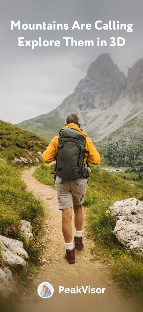
A hiker walking on a mountain trail with the text Mountains Are Calling Explore Them in 3D
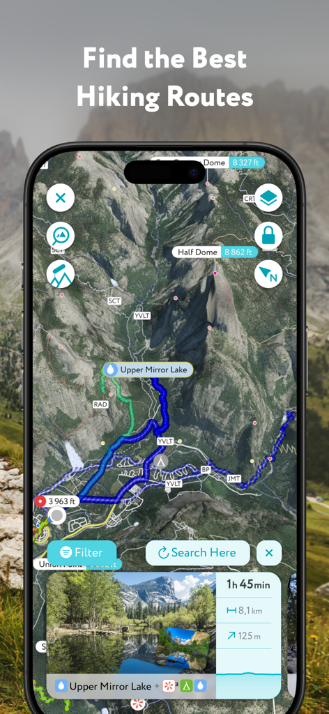
PeakVisor mobile app displaying 3D hiking routes and trail information for Half Dome
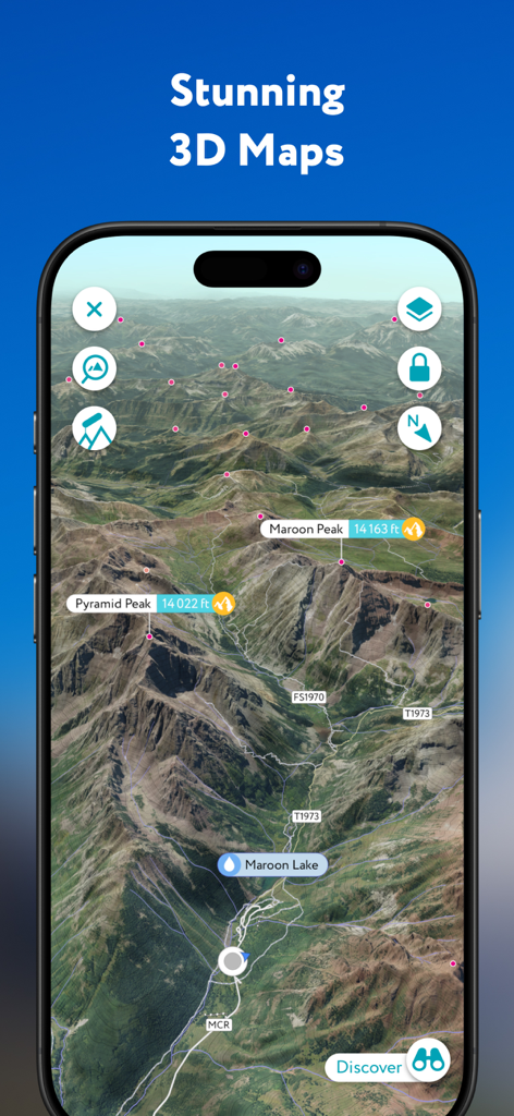
PeakVisor app showing a high precision 3D topographic map with labeled mountain peaks and hiking trails
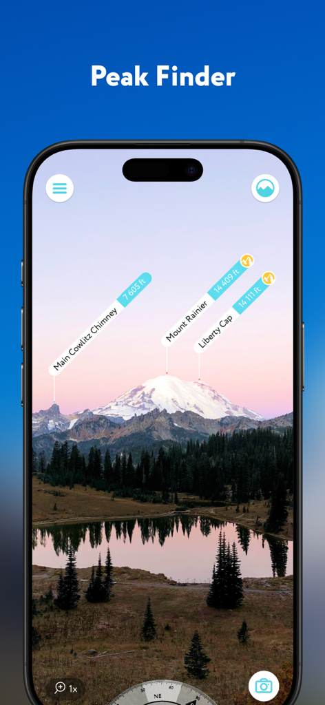
Augmented reality interface of PeakVisor app identifying mountain peaks like Mount Rainier with altitude tags.
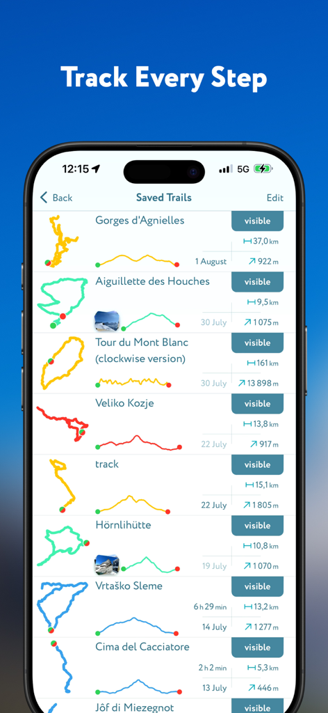
PeakVisor app screen showing a list of saved hiking trails with detailed route maps and elevation profiles
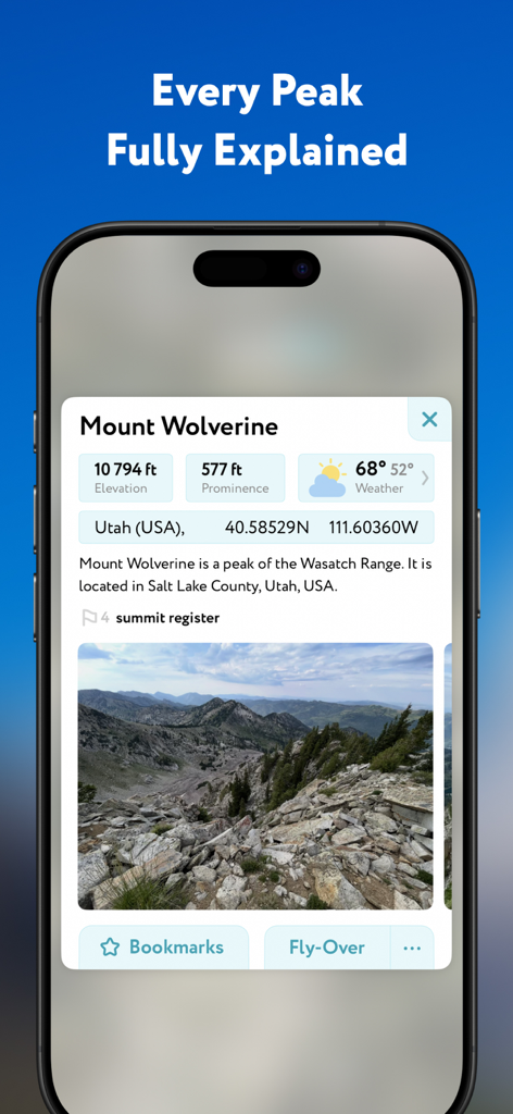
A detailed profile of Mount Wolverine in the PeakVisor app showing elevation prominence and weather data.
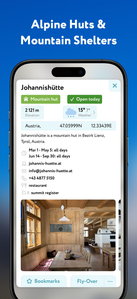
PeakVisor app screen showing details for the Johannishutte alpine hut in Austria with elevation and weather information.
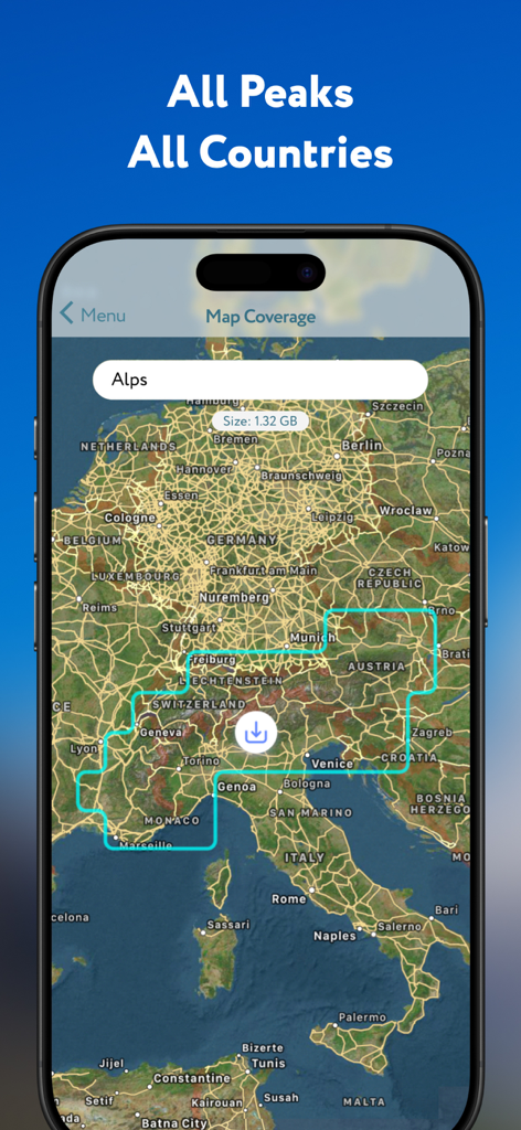
PeakVisor app screen showing a map of the Alps with a download option for offline mountain data.
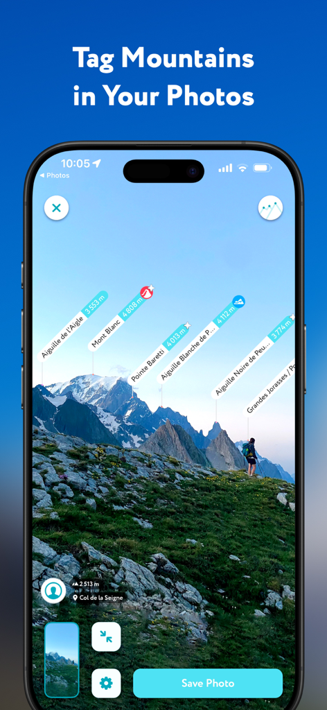
PeakVisor app interface showing identified mountain peaks with name and elevation tags in a landscape photo.
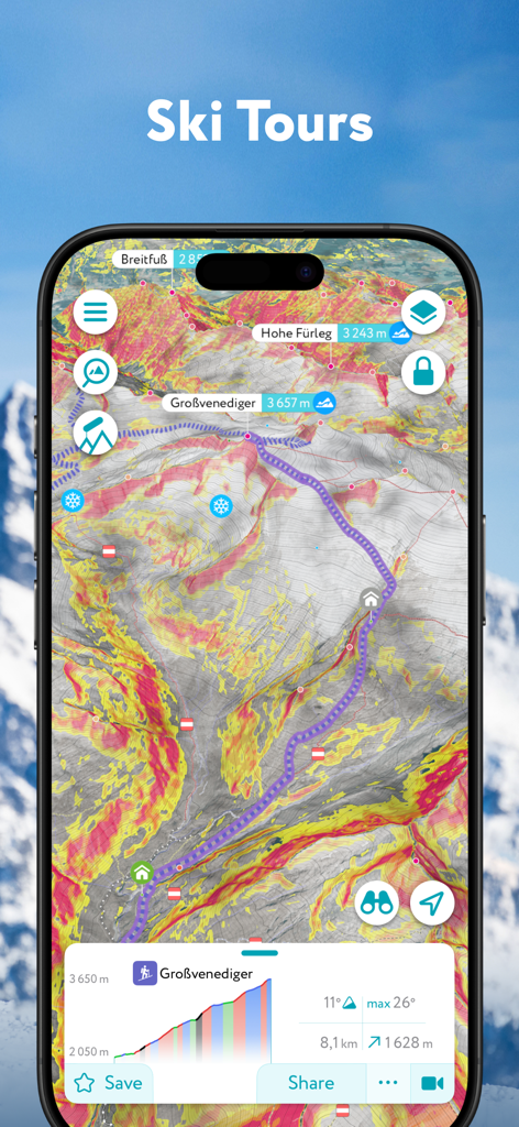
A 3D topographic map on the PeakVisor app displaying a ski tour route with slope steepness safety overlays
Description
Download
More Like This
Apps with similar features and user experience


This page is not an official page of the app or its developer, but an independent editorial publication created for informational and commentary purposes. Unless expressly stated otherwise, neither the app nor its developer is affiliated with, endorsed by, sponsored by, authorized by, or otherwise officially connected with MWM, Apple, Google Play, the app publisher, or the app's developer, and nothing on this page implies that the app was developed using MWM's services. Any trademarks, logos, screenshots, and other content remain the property of their respective owners.