This page is not an official page of the app or its developer, but an independent editorial publication created for informational and commentary purposes. Unless expressly stated otherwise, neither the app nor its developer is affiliated with, endorsed by, sponsored by, authorized by, or otherwise officially connected with MWM, Apple, Google Play, the app publisher, or the app's developer, and nothing on this page implies that the app was developed using MWM's services. Any trademarks, logos, screenshots, and other content remain the property of their respective owners.

Cyclone - hurricane tracker
Stay ahead of every storm with high-resolution imagery from NOAA and NASA. Track hurricane paths, access 10-day forecasts, and explore interactive maps designed for total preparedness and peace of mind.
Downloads
157K+User Rating
Total Ratings
500Publisher
Category
WeatherLocales
30Latest Version
3.1Size
131.9 MBFirst Released
Sep 16, 2013Unmatched Storm Intelligence for Total Preparedness
Harness the power of professional-grade meteorological data to protect your home, family, and assets with real-time global tracking.
Elite Satellite Surveillance
Monitor high-resolution cloud animations powered by NOAA and NASA, giving you the same visual clarity used by weather professionals.
Precision Path Projections
Stay ahead of the curve with detailed storm tracks and forecasts, allowing you to make critical safety decisions with confidence.
Frequently Asked Questions
Everything you need to know about Cyclone - hurricane tracker
What is Cyclone - hurricane tracker?
Cyclone is a comprehensive weather app providing real-time insights and visuals. It delivers live satellite imagery, tracks storms worldwide, and offers interactive map exploration with current weather and 10-day forecasts.
Does Cyclone - hurricane tracker provide live satellite imagery?
Yes, Cyclone provides high-resolution live satellite imagery. It features cloud cover animations for North America, Europe, Japan, Australia, and parts of Russia, ensuring detailed visual weather tracking.
Which data sources does Cyclone - hurricane tracker use for weather information?
Cyclone uses trusted sources like NOAA-NASA GOES, EUMETSAT, SPC, and GDAC. These sources provide accurate, global weather data, ensuring reliable information for storm tracking and forecasts.
Can Cyclone - hurricane tracker track hurricanes and typhoons?
Yes, Cyclone tracks hurricanes, typhoons, and cyclones worldwide. It displays precise projected paths and provides detailed forecasts for these major storm systems.
Does Cyclone show current weather conditions?
Yes, Cyclone displays current weather conditions. Users can access details like temperature, humidity, wind, and water temperature through an intuitive pop-up window on interactive maps.
Can I see a 10-day weather forecast in Cyclone - hurricane tracker?
Yes, Cyclone provides a 10-day weather forecast. This feature is accessible through an intuitive pop-up window, showing predicted weather conditions and temperatures for upcoming days.
What types of maps are available in Cyclone - hurricane tracker?
Cyclone offers dynamic terrain, satellite, and standard maps. These maps include smooth zoom and pan functionality for interactive exploration of weather conditions and storm tracks globally.
Does Cyclone - hurricane tracker provide severe weather alerts?
Yes, Cyclone provides severe weather alerts. These alerts include warnings such as Severe Thunderstorm Watches and Excessive Heat Warnings, detailing affected areas and timeframes.
Can Cyclone control animation playback?
Yes, Cyclone allows users to control animation playback and speed. This feature provides a tailored experience for viewing high-resolution cloud cover animations and storm tracks.
Is Cyclone - hurricane tracker optimized for low-bandwidth networks?
Yes, Cyclone ensures fast performance and fluid animations even on low-bandwidth networks. This optimization provides a seamless user experience regardless of internet connection quality.
The following screenshots and description are sourced directly from the app's official store listing and are the property of the app developer.
App Store
Screenshots
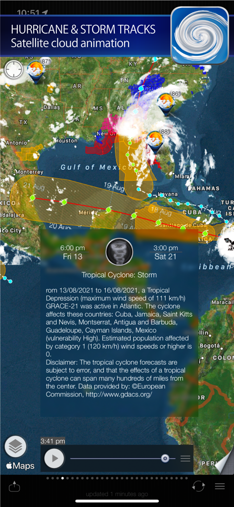
Interactive hurricane tracking map with projected storm paths and satellite imagery for Tropical Cyclone Grace.
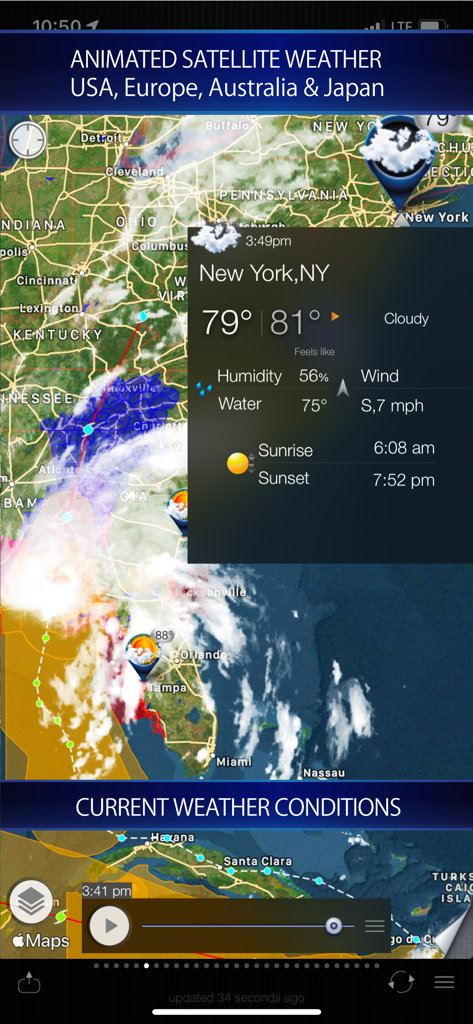
Cyclone app showing animated satellite weather and current conditions for New York on a map
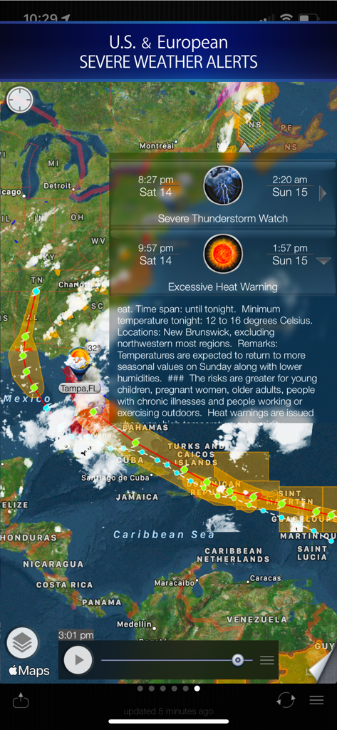
Cyclone app map showing hurricane tracking paths and severe weather alerts for Florida and the Caribbean
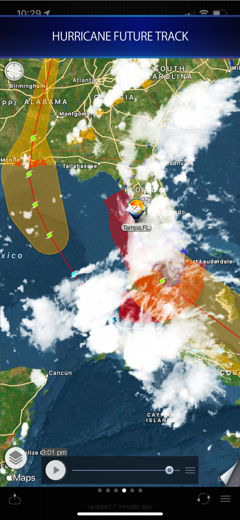
Map showing a hurricane future track over Florida and Tampa
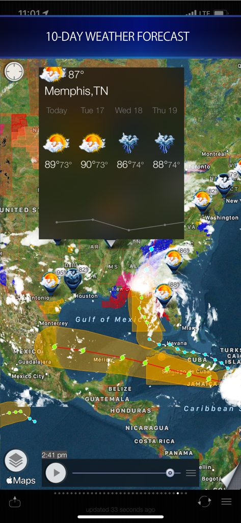
Satellite map showing hurricane paths and 10 day weather forecast
Description
Download
More Like This
Apps with similar features and user experience

墨迹天气-MojiWeather
Beijing MojiFengyun Technology Co.,Ltd.

Windy.com
Windyty, SE

天气通
Weibo Internet Technology (China) Co.Ltd.

Zoom Earth - Weather Forecast
Neave Interactive Limited

实时天气-40日精准天气实时预报
犇 牛

MyRadar Accurate Weather Radar
Aviation Data Systems, Inc

Ventusky: Weather & Live Radar
Ventusky s.r.o.

FOX Weather: Daily Forecasts
Fox News Network, LLC

2345天气王-天气和空气质量查询小组件
Shanghai 2345 Network Technology Co., Ltd.
This page is not an official page of the app or its developer, but an independent editorial publication created for informational and commentary purposes. Unless expressly stated otherwise, neither the app nor its developer is affiliated with, endorsed by, sponsored by, authorized by, or otherwise officially connected with MWM, Apple, Google Play, the app publisher, or the app's developer, and nothing on this page implies that the app was developed using MWM's services. Any trademarks, logos, screenshots, and other content remain the property of their respective owners.