This page is not an official page of the app or its developer, but an independent editorial publication created for informational and commentary purposes. Unless expressly stated otherwise, neither the app nor its developer is affiliated with, endorsed by, sponsored by, authorized by, or otherwise officially connected with MWM, Apple, Google Play, the app publisher, or the app's developer, and nothing on this page implies that the app was developed using MWM's services. Any trademarks, logos, screenshots, and other content remain the property of their respective owners.

Eos Tools Pro
The essential companion for Arrow and Skadi GNSS receivers, providing real-time quality control, orthometric heights, and seamless integration with Esri ArcGIS® Field Maps.
Downloads
72K+User Rating
Total Ratings
0Publisher
Category
NavigationLocales
3Latest Version
4.6.1Size
37.1 MBFirst Released
Mar 18, 2015Unrivaled Field Precision
Eos Tools Pro transforms your mobile device into a high-accuracy scientific instrument, bridging the gap between Arrow series GNSS hardware and professional GIS workflows.
Centimeter-Level RTK Connectivity
Leverage the built-in NTRIP client to access RTK and DGNSS correction networks, ensuring sub-meter and centimeter accuracy for your most critical surveys.
Deep ArcGIS Field Maps Integration
Unlock advanced GIS capabilities including laser offset mapping and underground asset location directly within the industry-standard Esri ecosystem.
The following screenshots and description are sourced directly from the app's official store listing and are the property of the app developer.
App Store
Screenshots
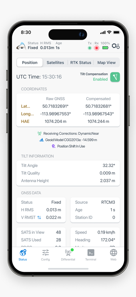
Eos Tools Pro app interface showing high-precision GNSS position coordinates and tilt compensation data
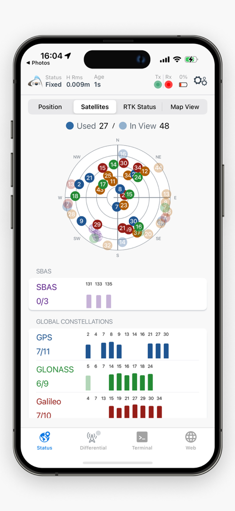
Eos Tools Pro satellite skyplot and GNSS constellation tracking data
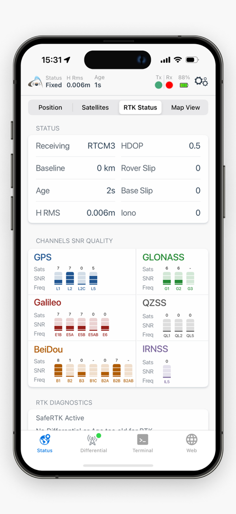
Eos Tools Pro app screen displaying real-time RTK status and GNSS satellite signal quality for professional mapping.
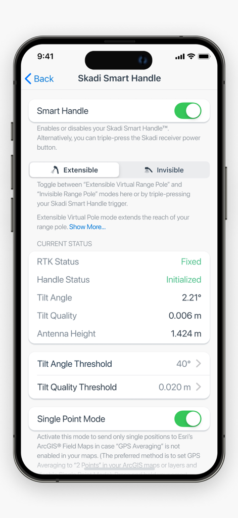
Skadi Smart Handle configuration screen in Eos Tools Pro displaying RTK status tilt angle and antenna height for high precision GNSS surveying
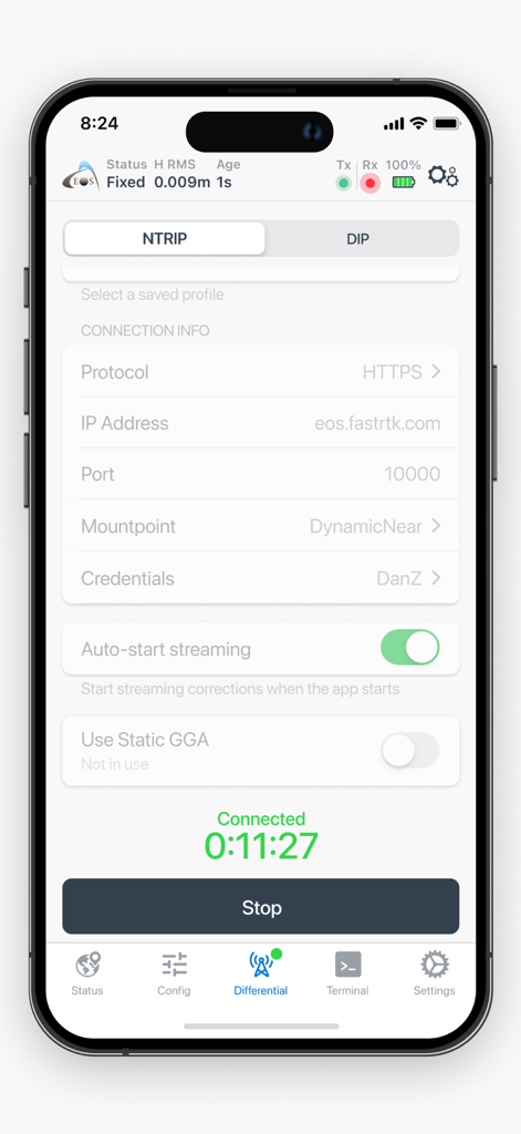
Eos Tools Pro app interface showing NTRIP configuration for high precision GNSS mapping
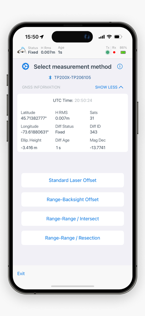
Eos Tools Pro app interface showing measurement method selection and high precision GNSS status information.
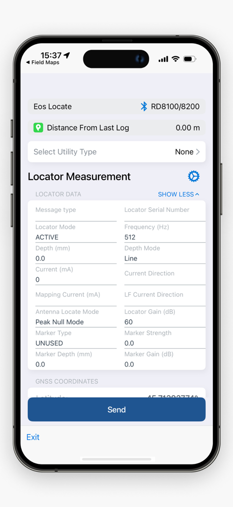
Interface of Eos Tools Pro showing locator measurement data for underground utility mapping
Description
Download
More Like This
Top-ranked apps in the same category

Google Maps
Google LLC

Waze Navigation & Live Traffic
waze

AMap Global
AutoNavi Information Technology Co. Ltd.

百度地图-路线规划,出行必备
Beijing Baidu Netcom Science & Technology Co.,Ltd

Moovit: Bus & Transit Tracker
Moovit App Global LTD

Transit • Subway & Bus Times
9280-0366 Quebec inc.

ParkMobile: Park. Pay. Go.
Parkmobile USA, Inc

腾讯地图-路线规划,导航地铁打车出行
Shenzhen Tencent Computer Systems Company Limited

Île-de-France Mobilités
Ile de France Mobilites
This page is not an official page of the app or its developer, but an independent editorial publication created for informational and commentary purposes. Unless expressly stated otherwise, neither the app nor its developer is affiliated with, endorsed by, sponsored by, authorized by, or otherwise officially connected with MWM, Apple, Google Play, the app publisher, or the app's developer, and nothing on this page implies that the app was developed using MWM's services. Any trademarks, logos, screenshots, and other content remain the property of their respective owners.