This page is not an official page of the app or its developer, but an independent editorial publication created for informational and commentary purposes. Unless expressly stated otherwise, neither the app nor its developer is affiliated with, endorsed by, sponsored by, authorized by, or otherwise officially connected with MWM, Apple, Google Play, the app publisher, or the app's developer, and nothing on this page implies that the app was developed using MWM's services. Any trademarks, logos, screenshots, and other content remain the property of their respective owners.

海拔地图-实时海拔测量仪卫星地图GPS经纬度定位
专为攀登者与徒步者打造的高精度卫星地图与3km分辨率气象预报。集成实时GPS定位、轨迹记录与水印相机,助您在极端环境中从容决策,完美记录巅峰时刻。
Downloads
25K+User Rating
Total Ratings
600Publisher
Category
NavigationLocales
1Latest Version
1.1.2Size
8.7 MBFirst Released
Oct 14, 2024Conquer the Wild with Precision Data
Your all-in-one companion for high-altitude exploration, combining professional-grade satellite maps, hyper-local weather, and precise elevation tracking.
Pro-Grade Elevation Tracking
Navigate with confidence using real-time sensor-based altitude data and high-definition satellite terrain maps designed for the backcountry.
Hyper-Local Weather Forecasts
Stay ahead of mountain storms with 3km-resolution data, providing accurate hourly updates on wind, precipitation, and humidity.
Frequently Asked Questions
Everything you need to know about 海拔地图-实时海拔测量仪卫星地图GPS经纬度定位
What is Altitude Map?
Altitude Map is a professional outdoor application. It provides satellite maps, real-time altitude measurement, high-precision weather forecasts, and compass positioning for safe and informed outdoor activities. It is your essential partner for exploring nature.
Does the Altitude Map app measure altitude in real-time?
Yes, Altitude Map provides real-time and precise altitude measurements. It displays the current exact altitude, helping users adjust their pace, control breathing, and prevent high-altitude sickness. It also shows current oxygen content and air pressure.
What map features does the Altitude Map app offer?
Altitude Map offers specialized satellite map functions optimized for outdoor use, providing high-definition topographic information. Users can also switch between various map types, including satellite and electronic road maps, to suit their needs.
What kind of weather information does Altitude Map provide?
Altitude Map provides precise weather forecasts including temperature, precipitation, wind speed, and air humidity. It features real-time weather data with a resolution up to 3km, aiding decision-making in high-altitude and extreme environments.
Can I use Altitude Map offline?
Yes, Altitude Map supports offline use. Core functions such as altitude measurement, positioning, and viewing cached weather information operate normally even without network signals, ensuring functionality in remote areas.
Does Altitude Map include a compass?
Yes, Altitude Map includes a high-precision compass positioning function. It provides accurate directional guidance to help users navigate and find the correct route in unknown environments, offering reliable support for every step.
What does the watermark camera feature do in Altitude Map?
The Altitude Map watermark camera automatically adds time, location, altitude, and weather information to photos. This creates a detailed and meaningful exploration log, which enhances memories and makes sharing adventures with friends more vivid.
Does Altitude Map record outdoor activity tracks?
Yes, Altitude Map records users' movement tracks for activities like hiking and climbing. This feature allows users to review their journey and share their footsteps with companions. Detailed track recording is part of the subscription version.
How much does the Altitude Map subscription cost?
The Altitude Map annual subscription costs 98 RMB. Users' iTunes accounts are automatically charged to ensure continuous access to premium features for each subscription cycle.
How do I cancel the Altitude Map subscription?
Users can cancel the Altitude Map subscription via their iOS device settings. Navigate to 'Settings' > 'Apple ID' > 'iTunes & App Store' > 'View Apple ID' > 'Subscriptions', find '海拔地图' (Altitude Map), and select 'Cancel Subscription'.
Does Altitude Map consume significant battery life?
Yes, Altitude Map's track recording and other features continuously use satellite positioning services to obtain accurate data. This continuous usage, even in the background, can lead to increased power consumption and affect battery life.
What are the benefits of an Altitude Map subscription?
An Altitude Map subscription provides detailed travel track recording and data viewing, important location marking, a 30-day weather forecast, precise hourly forecasts for weather data like temperature and wind, and a one-click environmental watermark camera.
Can Altitude Map mark locations on its maps?
Yes, Altitude Map allows users to add custom markers on the map. This feature is useful for planning future trips by marking suitable camping sites or recording the locations of resupply points along a route.
Does Altitude Map offer global map and weather coverage?
Yes, Altitude Map supports weather forecasting and map browsing across the world. It provides global coverage, ensuring seamless data viewing and functionality regardless of the user's geographical location.
The following screenshots and description are sourced directly from the app's official store listing and are the property of the app developer.
App Store
Screenshots
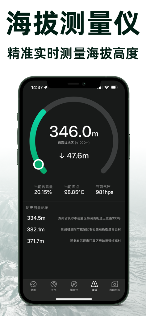
Mobile app screen displaying real-time altitude data and environmental stats like air pressure and oxygen levels
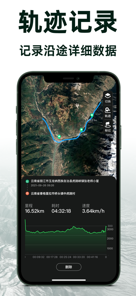
Smartphone screen showing the Elevation Map app interface with a satellite view of a hiking track and detailed data like distance, time, and elevation profile.
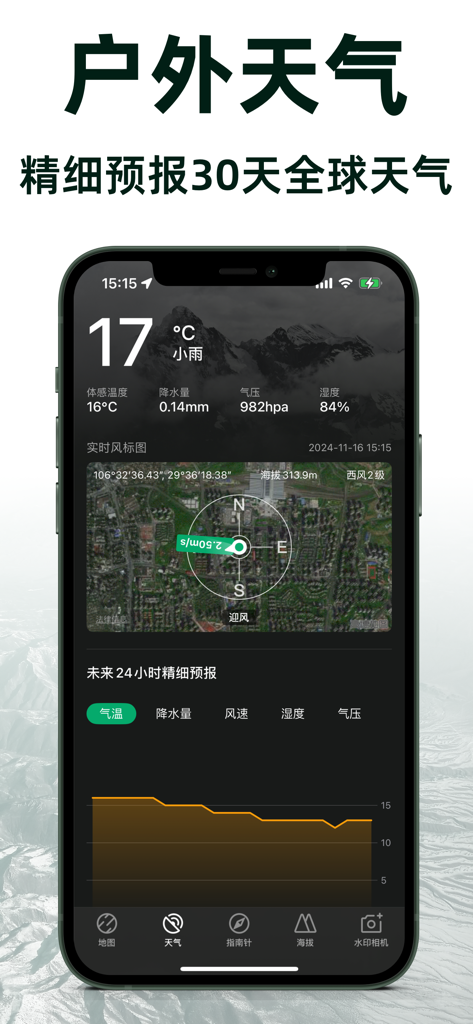
Elevation Map app weather screen showing detailed 30-day forecast and real-time altitude data
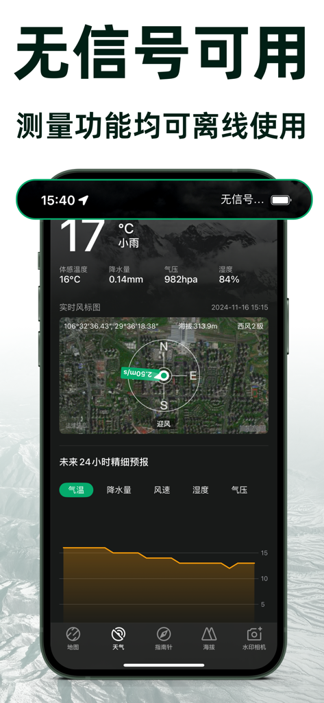
Smartphone displaying an elevation map app interface with offline altitude and weather information
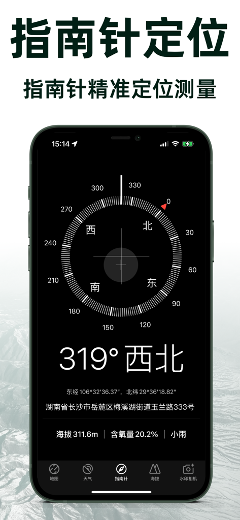
Digital compass interface in the Elevation Map app showing heading coordinates and altitude information

Elevation Map mobile app satellite view showing marked location pins with altitude data and GPS coordinates
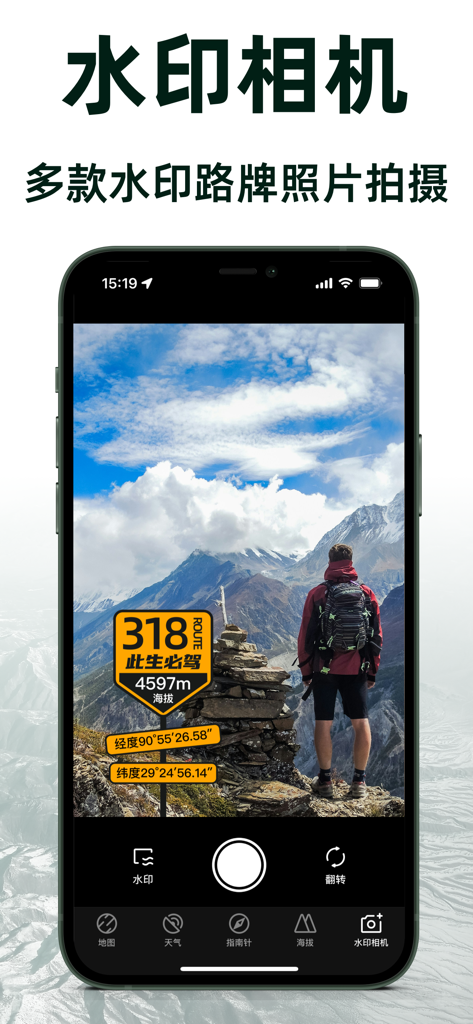
Mobile app interface for Watermark Camera showing a hiker in the mountains with altitude and coordinate overlays.
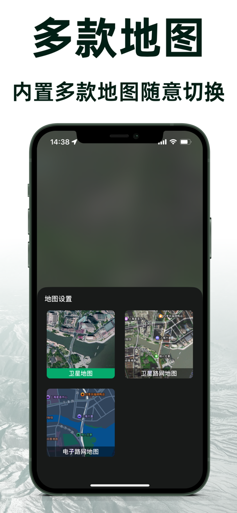
Elevation Map app interface displaying different map styles including satellite and road network views
Description
Download
More Like This
Top-ranked apps in the same category

Google Maps
Google LLC

Waze Navigation & Live Traffic
waze

AMap Global
AutoNavi Information Technology Co. Ltd.

百度地图-路线规划,出行必备
Beijing Baidu Netcom Science & Technology Co.,Ltd

Moovit: Bus & Transit Tracker
Moovit App Global LTD

Transit • Subway & Bus Times
9280-0366 Quebec inc.

ParkMobile: Park. Pay. Go.
Parkmobile USA, Inc

腾讯地图-路线规划,导航地铁打车出行
Shenzhen Tencent Computer Systems Company Limited

Île-de-France Mobilités
Ile de France Mobilites
This page is not an official page of the app or its developer, but an independent editorial publication created for informational and commentary purposes. Unless expressly stated otherwise, neither the app nor its developer is affiliated with, endorsed by, sponsored by, authorized by, or otherwise officially connected with MWM, Apple, Google Play, the app publisher, or the app's developer, and nothing on this page implies that the app was developed using MWM's services. Any trademarks, logos, screenshots, and other content remain the property of their respective owners.