This page is not an official page of the app or its developer, but an independent editorial publication created for informational and commentary purposes. Unless expressly stated otherwise, neither the app nor its developer is affiliated with, endorsed by, sponsored by, authorized by, or otherwise officially connected with MWM, Apple, Google Play, the app publisher, or the app's developer, and nothing on this page implies that the app was developed using MWM's services. Any trademarks, logos, screenshots, and other content remain the property of their respective owners.

National Hurricane Center Data
Skip the media hype and access raw meteorological data. From spaghetti models to 1-minute satellite imagery, get the precision tools you need to protect your home, family, and assets with confidence.
Downloads
1M+User Rating
Total Ratings
74K+Publisher
Category
WeatherLocales
2Latest Version
1.87Size
85.0 MBFirst Released
Oct 5, 2017Professional-Grade Tropical Intelligence
Access the exact raw data used by meteorologists. Skip the media hype with direct feeds from the NHC, NOAA, and advanced global forecast models designed for informed decision-making.
Advanced Predictive Modeling
Analyze the latest Spaghetti Models and 16-day global forecasts like the ECMWF and GFS to identify potential tracks before they reach the news.
High-Resolution Satellite Data
Monitor storm structure with GOES animations and 1-minute mesoscale imagery updates for a real-time view of evolving tropical threats.
Frequently Asked Questions
Everything you need to know about National Hurricane Center Data
What is the National Hurricane Center Data app?
The National Hurricane Center Data app for iOS is a comprehensive hurricane tracker providing over 100 products, including satellite imagery, forecast models, and advisory texts, to keep users informed during hurricane season.
Does the National Hurricane Center Data app include Spaghetti Models?
Yes, the National Hurricane Center Data app includes Spaghetti Models as part of its main features and forecast graphics, providing track forecasts from various global and AI ensemble models.
Can I receive hurricane notifications from the National Hurricane Center Data app?
Yes, the National Hurricane Center Data app offers Tropical Weather Push Notifications to alert users about important updates and developments during hurricane season.
What kind of satellite imagery does the National Hurricane Center Data app provide?
The National Hurricane Center Data app provides GOES Satellite Imagery animations with 15 different filters, including Visible, Infrared, True Color, and Nighttime Microphysics, plus high-resolution options with Pro subscription.
Does the National Hurricane Center Data app offer an Apple Watch application?
Yes, the National Hurricane Center Data app includes an Apple Watch app. It allows users to view wind speed and intensity updates, the latest satellite imagery, and choose from various Watch Complications.
What features are exclusive to the Pro Subscription in the National Hurricane Center Data app?
The Pro Subscription unlocks full-screen, high-resolution satellite imagery, 16-day and other advanced weather forecast models, next-gen hurricane models, and various cyclogenesis and tropical cyclone tracking products.
Does the National Hurricane Center Data app provide wind speed probability forecasts?
Yes, the National Hurricane Center Data app provides storm-specific graphics including Tropical Storm Wind (Most Likely) and Hurricane Wind Probability, as displayed in the 5-day forecast section.
Can users view near real-time satellite imagery with the National Hurricane Center Data app?
Yes, Pro subscribers to the National Hurricane Center Data app can access Mesoscale near real-time satellite imagery, which typically features 1-minute temporal resolution when available.
What types of forecast models are available in the National Hurricane Center Data app?
The National Hurricane Center Data app provides models like GFS, GEFS, NAEFS, HRRR, ECMWF, and specialized hurricane models (HAFS, HMON, HWRF, CTCX), many of which are part of the Pro Subscription.
Does the National Hurricane Center Data app offer a storm track forecast?
Yes, the National Hurricane Center Data app offers a Cone Track Forecast within its storm-specific graphics. This displays the probable path of the storm center over several days.
Does the National Hurricane Center Data app provide local storm threat information?
Yes, the National Hurricane Center Data app provides Local Storm Threat Graphics including Flooding Rain, Wind, Surge, Tornado Threats, and Rainfall Totals. These are typically available before storm landfall.
Where can I find the Terms & Conditions for the National Hurricane Center Data app?
The Terms & Conditions for the National Hurricane Center Data app are available at the provided URL: https://lwbrandsllc.com/hurricane-app-terms-conditions/.
The following screenshots and description are sourced directly from the app's official store listing and are the property of the app developer.
App Store
Screenshots
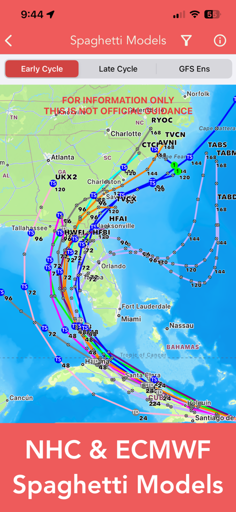
A map displaying NHC and ECMWF spaghetti models for a tropical storm tracking across Florida and the Southeast United States.
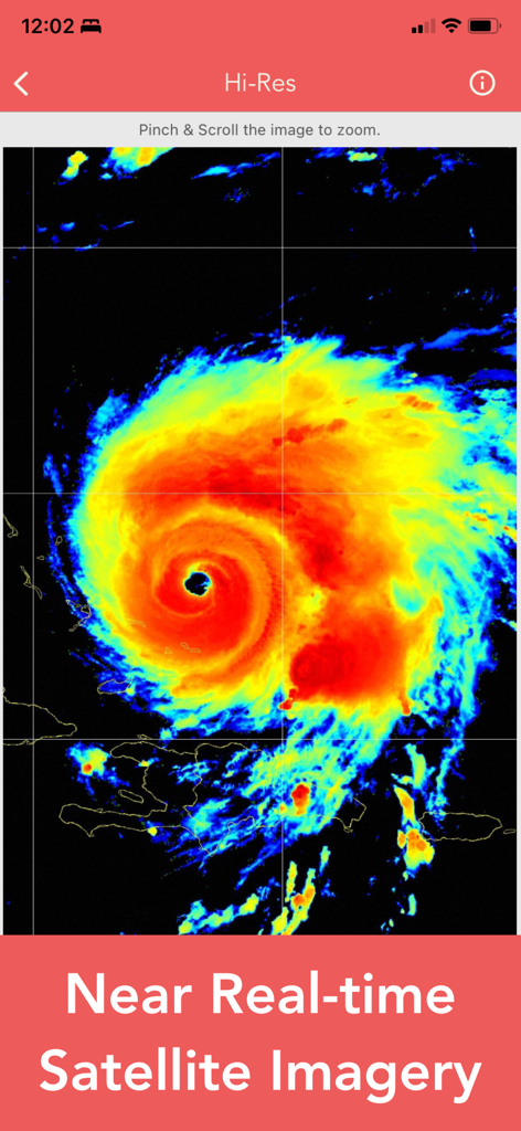
High resolution near real-time satellite imagery of a hurricane showing intense storm activity
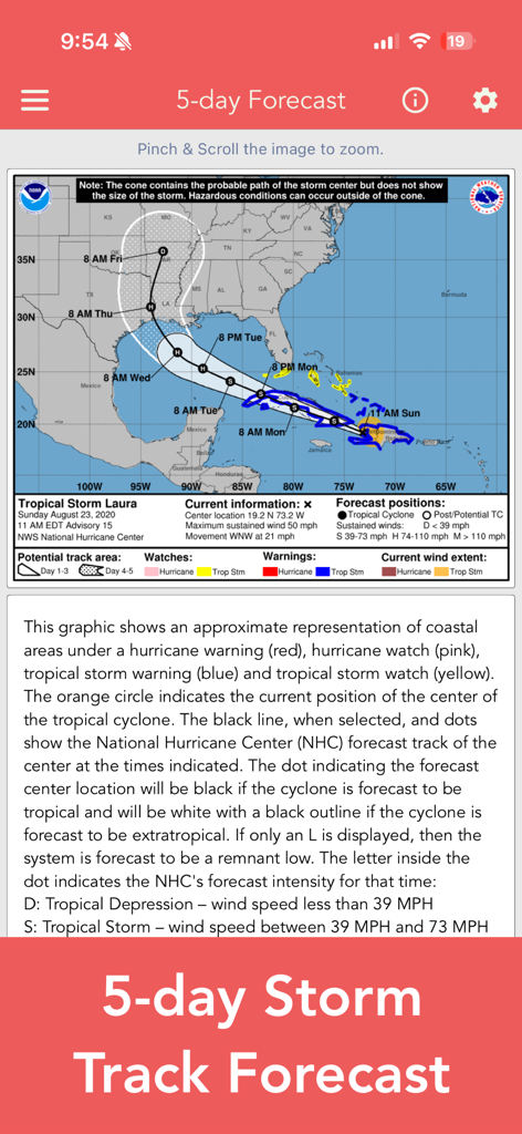
National Hurricane Center Data app showing a 5-day storm track forecast map with cone of uncertainty and tracking data
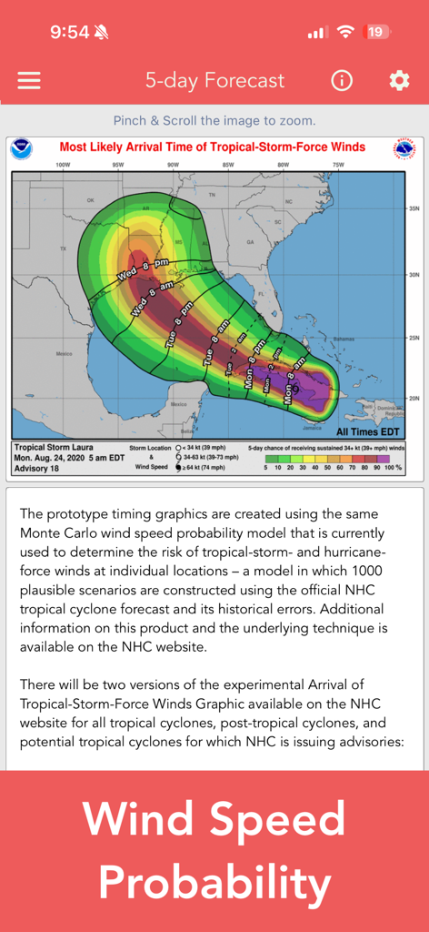
Wind speed probability map showing arrival times for Tropical Storm Laura
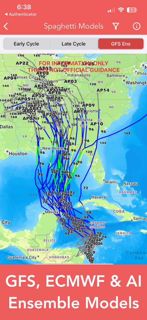
A map displaying hurricane spaghetti models with GFS, ECMWF, and AI ensemble tracking paths across the United States and Gulf of Mexico.
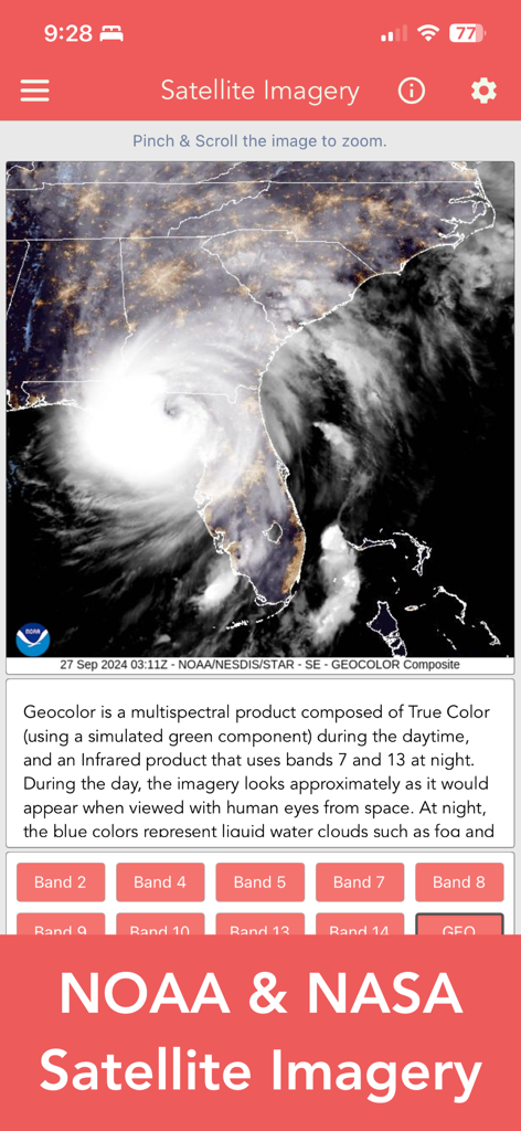
National Hurricane Center app showing NOAA and NASA satellite imagery of a hurricane over the coast
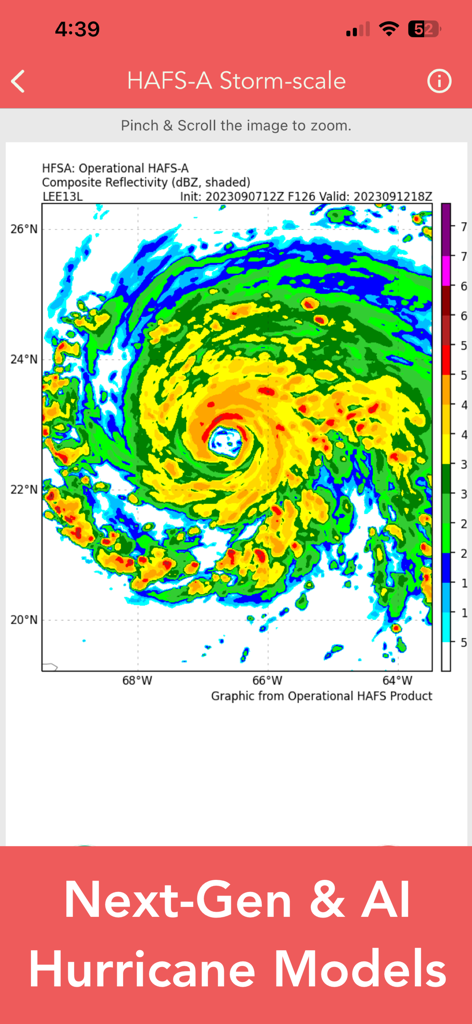
Technical storm-scale composite reflectivity map from the National Hurricane Center Data app showing hurricane intensity
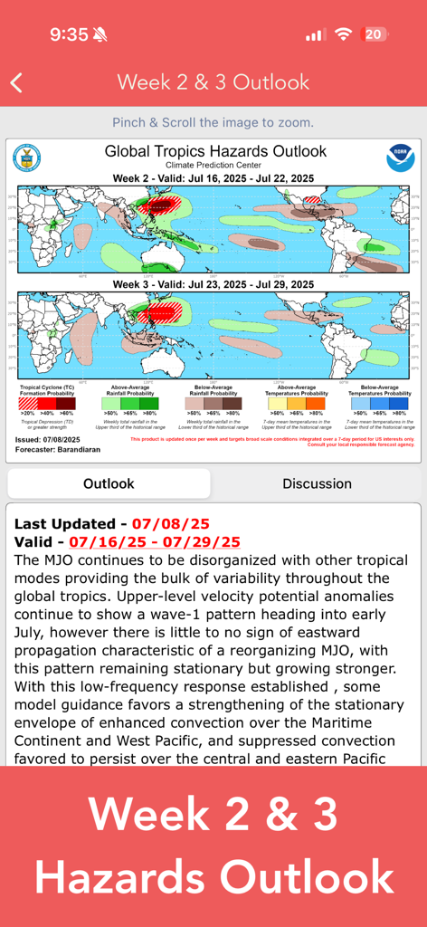
Global Tropics Hazards Outlook showing tropical cyclone and rainfall probability maps for weeks two and three.
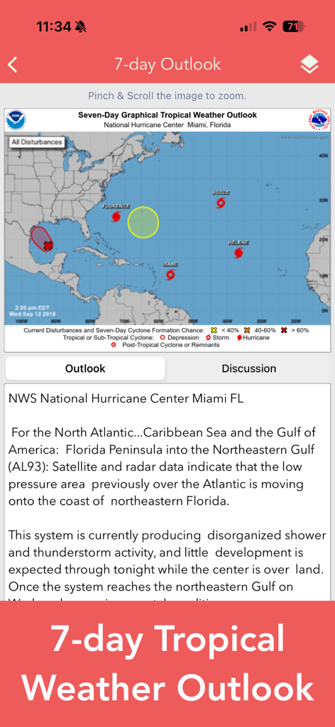
Seven day tropical weather outlook map and discussion screen on the National Hurricane Center Data app.
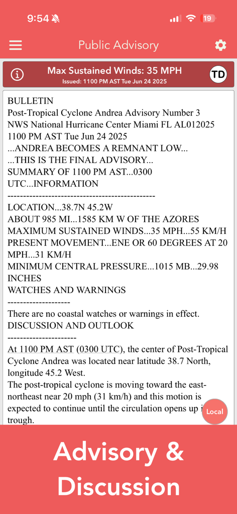
A screenshot of a public advisory report for a tropical cyclone with technical meteorological data.
Description
Download
More Like This
Apps with similar features and user experience

墨迹天气-MojiWeather
Beijing MojiFengyun Technology Co.,Ltd.

Windy.com
Windyty, SE

天气通
Weibo Internet Technology (China) Co.Ltd.

Zoom Earth - Weather Forecast
Neave Interactive Limited

实时天气-40日精准天气实时预报
犇 牛

MyRadar Accurate Weather Radar
Aviation Data Systems, Inc

Ventusky: Weather & Live Radar
Ventusky s.r.o.

FOX Weather: Daily Forecasts
Fox News Network, LLC

2345天气王-天气和空气质量查询小组件
Shanghai 2345 Network Technology Co., Ltd.
This page is not an official page of the app or its developer, but an independent editorial publication created for informational and commentary purposes. Unless expressly stated otherwise, neither the app nor its developer is affiliated with, endorsed by, sponsored by, authorized by, or otherwise officially connected with MWM, Apple, Google Play, the app publisher, or the app's developer, and nothing on this page implies that the app was developed using MWM's services. Any trademarks, logos, screenshots, and other content remain the property of their respective owners.