This page is not an official page of the app or its developer, but an independent editorial publication created for informational and commentary purposes. Unless expressly stated otherwise, neither the app nor its developer is affiliated with, endorsed by, sponsored by, authorized by, or otherwise officially connected with MWM, Apple, Google Play, the app publisher, or the app's developer, and nothing on this page implies that the app was developed using MWM's services. Any trademarks, logos, screenshots, and other content remain the property of their respective owners.

ok2fly
Master Australian skies with real-time CASA safety rules, 4D NOTAMs, and precision temporal planning designed for both serious hobbyists and ReOC holders.
Downloads
43K+User Rating
Total Ratings
0Publisher
Category
NavigationLocales
1Latest Version
1.6.0Size
75.6 MBFirst Released
Jan 12, 2022Plan Your Mission with Absolute Confidence
The ultimate safety tool for professional and recreational drone pilots, combining CASA-compliant data with high-precision 4D situational awareness to protect your equipment and your license.
Official CASA-Integrated Compliance
Fly with total peace of mind using a tool fully integrated with the CASA RPAS Platform. Stay compliant with current safety rules and access official Airservices Australia authorization trials directly.
Hyper-Local Situational Awareness
Get more than a 'green light'. Visualize 4D restricted airspace, airport envelopes, and real-time NOTAMs, alongside local landmarks like schools, prisons, and parks to avoid legal disputes.
Frequently Asked Questions
Everything you need to know about ok2fly
What is ok2fly?
ok2fly is a drone safety tool that helps pilots plan missions, visualize airspace, and ensure compliance with regulations. It provides detailed maps and real-time operational environment analysis.
Does ok2fly show drone no-fly zones?
Yes, ok2fly provides detailed visualization of runway splays, airport envelopes, and automatically visualizes Restricted and Danger areas. It identifies no-fly zones based on active control towers.
How does ok2fly help with flight planning?
ok2fly surveys the immediate drone flight area with configurable radius, provides detailed location reports, and adjusts map information to reflect activity at the proposed flight time.
Is ok2fly compliant with CASA regulations for drone flights?
Yes, ok2fly is fully compliant with the CASA RPAS Safety Rules and integrates with the CASA RPAS Platform. It was part of the CASA / Airservices Australia Airspace Authorisation trial.
Can ok2fly provide a detailed flight report?
Yes, ok2fly analyzes the airspace surrounding your location and provides a detailed location report. This report includes all known landmarks detected in the operational airspace.
Does ok2fly indicate if I can fly my drone?
Yes, ok2fly provides clear indications such as "OK 2 Fly," "Cannot Fly," or "Can Fly - With Conditions" based on the analysis of the proposed flight area and selected pilot qualifications.
What map data does ok2fly provide for Australia?
ok2fly provides a street-level vector map of the whole of Australia. It details standard street information, aviation details like obstacles, low-level aviation activities, and recreational sites.
Can I add overlays to the map in ok2fly?
Yes, ok2fly supports additional map overlays, including dynamic options like Air Traffic, Weather, and Lightning. Static overlays such as FIA Frequency Boundaries and Controlled Airspace are also available.
Does ok2fly display real-time NOTAMs for drone operations?
Yes, ok2fly automatically visualizes NOTAM activities affecting drone operations. It also provides continuously updated NAIPS NOTAM information for Restricted and Danger airspace with a paid subscription.
Can I configure ok2fly for my specific drone pilot qualifications?
Yes, ok2fly supports four CASA pilot types: Micro, Recreational, Commercial Excluded, and ReOC. Users can set their pilot type from the settings function to match their qualifications.
Does ok2fly require a paid subscription for all features?
No, some advanced features in ok2fly require a paid subscription. These include Commercial Excluded and ReOC pilot types, Layers option, NAIPS NOTAM inspection, and radio frequency data.
What is included with an ok2fly paid subscription?
A paid ok2fly subscription includes access to features like Commercial Excluded/ReOC pilot types, advanced map layers, NAIPS NOTAM inspection, radio frequency data, and AvPlan-EFB Standard Plus access.
Does ok2fly offer different display modes?
Yes, ok2fly provides both Light and Dark display modes for user preference. Users can switch between these modes to optimize visibility in different lighting conditions.
Is AvSoft Australia, the provider of ok2fly, a certified data provider?
Yes, AvSoft Australia, the developer of ok2fly, is a CASA Part 175 approved data provider. This ensures the app's data is authoritative and compliant with aviation standards.
The following screenshots and description are sourced directly from the app's official store listing and are the property of the app developer.
App Store
Screenshots
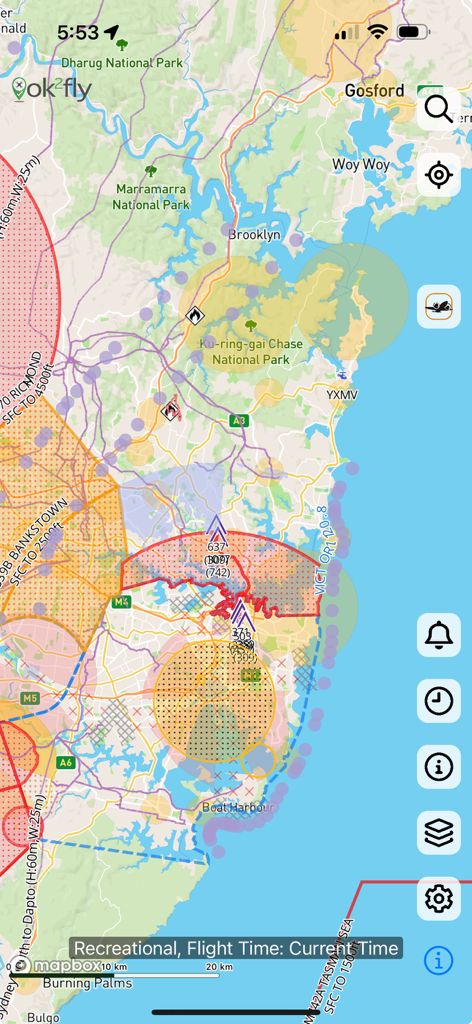
A detailed drone airspace map showing restricted flight zones and safety information in the ok2fly app
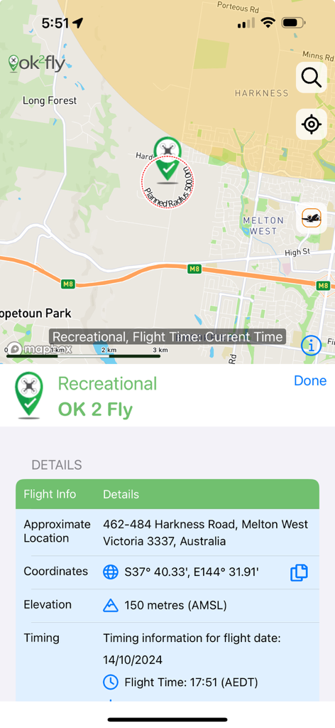
A screenshot of the ok2fly app showing a map and recreational drone flight planning details.
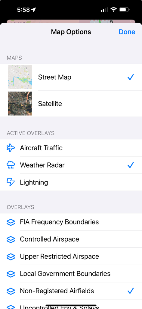
Map settings screen in the ok2fly app showing options for street maps satellite views and aviation overlays like weather radar and controlled airspace
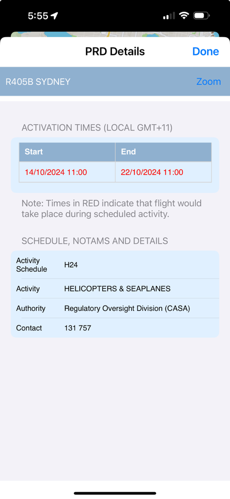
ok2fly app displaying PRD details for Sydney including activation times and helicopter activity schedules
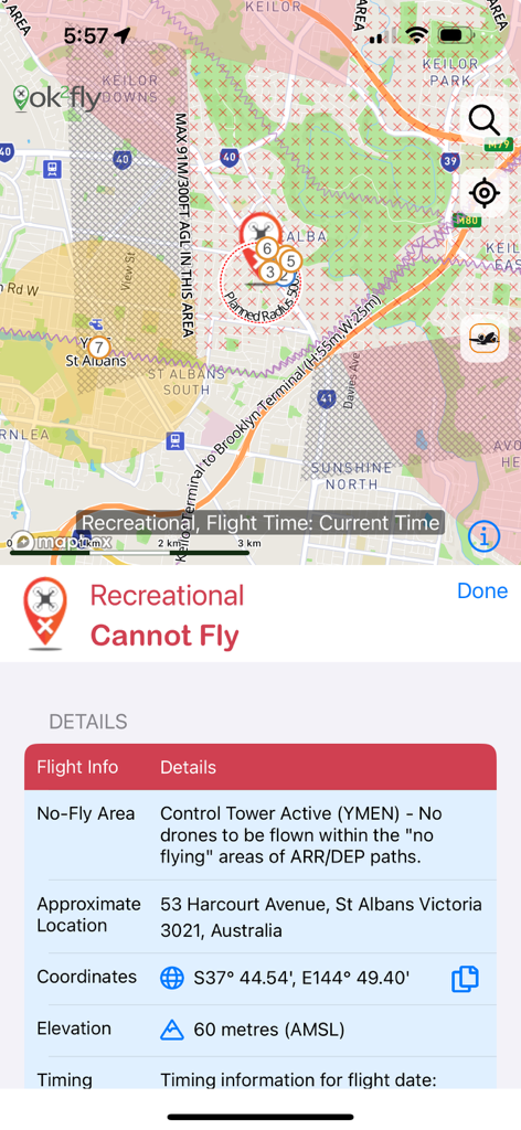
Screenshot of ok2fly app showing a drone no fly zone due to active control tower in Australia
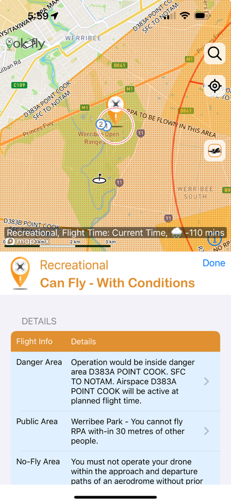
Screenshot of ok2fly app showing drone flight safety conditions and map for recreational pilots
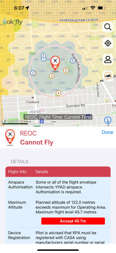
Screenshot of the ok2fly app displaying a restricted drone flight zone map and detailed safety warnings for REOC pilots.
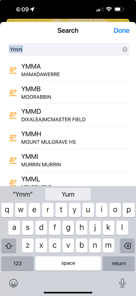
The ok2fly app search screen displaying a list of Australian airport codes and names
Description
Download
More Like This
Top-ranked apps in the same category

Google Maps
Google LLC

Waze Navigation & Live Traffic
waze

AMap Global
AutoNavi Information Technology Co. Ltd.

百度地图-路线规划,出行必备
Beijing Baidu Netcom Science & Technology Co.,Ltd

Moovit: Bus & Transit Tracker
Moovit App Global LTD

Transit • Subway & Bus Times
9280-0366 Quebec inc.

ParkMobile: Park. Pay. Go.
Parkmobile USA, Inc

腾讯地图-路线规划,导航地铁打车出行
Shenzhen Tencent Computer Systems Company Limited

Île-de-France Mobilités
Ile de France Mobilites
This page is not an official page of the app or its developer, but an independent editorial publication created for informational and commentary purposes. Unless expressly stated otherwise, neither the app nor its developer is affiliated with, endorsed by, sponsored by, authorized by, or otherwise officially connected with MWM, Apple, Google Play, the app publisher, or the app's developer, and nothing on this page implies that the app was developed using MWM's services. Any trademarks, logos, screenshots, and other content remain the property of their respective owners.