このページはアプリまたはその開発者の公式ページではなく、情報提供および論評を目的として作成された独立した編集出版物です。明示的に別段の記載がない限り、アプリおよびその開発者は、MWM、Apple、Google Play、アプリのパブリッシャー、またはアプリの開発者と提携、承認、後援、認可、またはその他の公式的な関係はなく、このページのいかなる内容も、アプリがMWMのサービスを使用して開発されたことを意味するものではありません。すべての商標、ロゴ、スクリーンショット、その他のコンテンツはそれぞれの所有者の財産です。

Airmate
プロフェッショナルな移動マップ、FAAチャート、リアルタイムの状況認識でコックピットをレベルアップしましょう。高額なサブスクリプション料金なしで、フル機能の電子フライトバッグのパワーを体験してください。
ダウンロード
438K+ユーザー評価
評価数
100開発元
カテゴリ
Navigation対応言語
7最新バージョン
3.20サイズ
219.5 MBリリース日
2017年7月22日プロフェッショナルEFBで空をマスターする
Airmateは、サブスクリプションの疲れなしにプロフェッショナルな信頼性を求める一般航空パイロットのために設計された、包括的なフライトプランニング、ナビゲーション、および安全ツールスイートを提供します。
完全な米国フライトプランニング
米国および200以上の国々で、無料のFAAセクショナルト、ターミナル手順、および自動ルートツールにアクセスして、数秒でVFRまたはIFRフライトプランを提出できます。
高度な状況認識
3D Synthetic Vision、バックアップEFIS、リアルタイムADS-Bトラフィック統合により安全性を向上させ、あらゆる環境で航空機を先取りしましょう。
よくある質問
について知っておくべきこと Airmate
Airmateアプリとは何ですか?
Airmateは、パイロット向けの無料では使いやすいフライトプランニングおよび気象アプリケーションで、状況認識を向上させ、必須の航空データと地図に即座にアクセスできるように設計されています。
Airmateはパイロット向けの無料アプリですか?
はい、Airmateは無料のアプリケーションです。世界中の航空データベースと地形図に無料でアクセスでき、アップデートも無料です。
AirmateはIFRおよびVFR空港プレートを提供していますか?
はい、AirmateはIFRおよびVFR空港プレートを提供しています。これらのプレートは、米国(FAAチャート)、ヨーロッパ、および200以上のその他の国で無料で利用でき、多くは地理参照されています。
Airmateは飛行中の気象情報表示を提供できますか?
はい、Airmateは飛行中の気象表示が可能です。外部ADS-B受信機と連携すると、FIS-B気象情報を受信し、最新の気象情報とNOTAMが含まれています。
Airmateはフライトプランニングにどのように役立ちますか?
Airmateは、最適なルートを選択するための自動ルート機能、VFR/IFRフライトプランの提出、および提出済みプランの管理/遅延/キャンセルを提供することで、フライトプランニングを支援します。
Airmateは飛行中の交通表示をサポートしていますか?
はい、Airmateは交通表示をサポートしています。外部ADS-B受信機を介して移動マップ上に近くの交通を表示したり、商用航空機やその他の航空機を含むモバイルネットワーク経由で近隣の交通を表示したりします。
Airmateは航空機の姿勢指示器をシミュレートできますか?
はい、Airmateは航空機の姿勢指示器をシミュレートできます。飛行中にEFIS風のビューでバックアップ姿勢指示器と飛行パラメータを表示します。
AirmateはSynthetic Visionを提供していますか?
はい、AirmateはSynthetic Visionを提供しています。この機能は、EFIS風のビューで前方の起伏のある地形を表示し、世界中で利用可能です。景観データは一部の国では購入により利用可能です。
Airmateはどのような種類の航空データを提供していますか?
Airmateは、空港、航法ビーコン、ウェイポイント、航空路、障害物、規制区域/制限区域を含む世界中の航空データベースを提供し、無料で更新されます。また、地形図と標高データも提供します。
Airmateはフライトの記録と再生ができますか?
はい、Airmateはフライトを記録できます。ユーザーは後でフライトを再生したり、GPX形式でフライトパスをエクスポートしたり、飛行したフライトからパイロットログのエントリを自動計算したりできます。
Airmateは複数のデバイス間でデータを同期しますか?
はい、Airmateはデバイス間でデータを同期します。計画済みのフライトと飛行済みのフライト、ユーザーウェイポイント、ユーザー機材をクラウドに保存し、デバイス間とAirmate Webフライトプランニング間で同期します。
以下のスクリーンショットと説明は、アプリの公式ストアリスティングから直接取得されたものであり、アプリ開発者の所有物です。
アプリストア
スクリーンショット
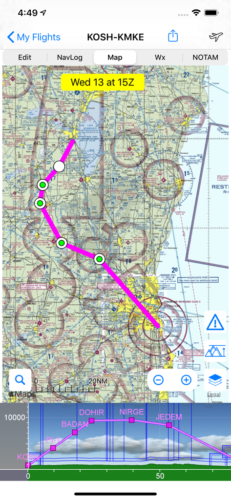
Airmateアプリが、航空セクショナルトチャート上にフライトルートと垂直プロファイルビューを表示しています
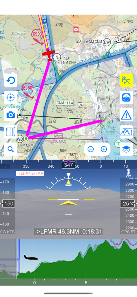
Airmateアプリが、Synthetic Visionとフライトプロファイルを備えた移動航空マップEFISを表示しています
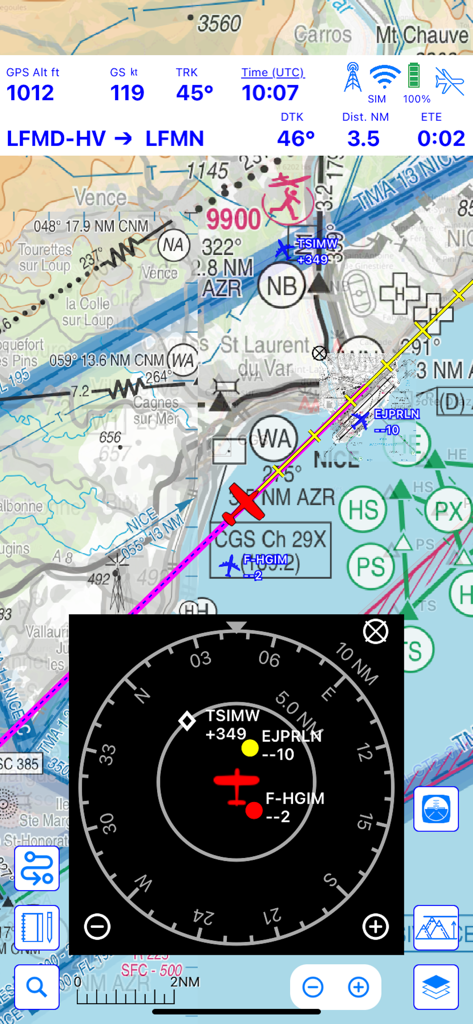
Airmateフライトナビゲーションインターフェースが、統合トラフィックレーダーとフライトテレメトリを備えた移動マップを表示しています
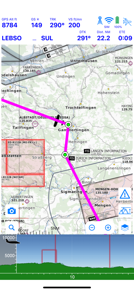
Airmateアプリの移動マップ表示には、フライトテレメトリと地形プロファイルが表示されています
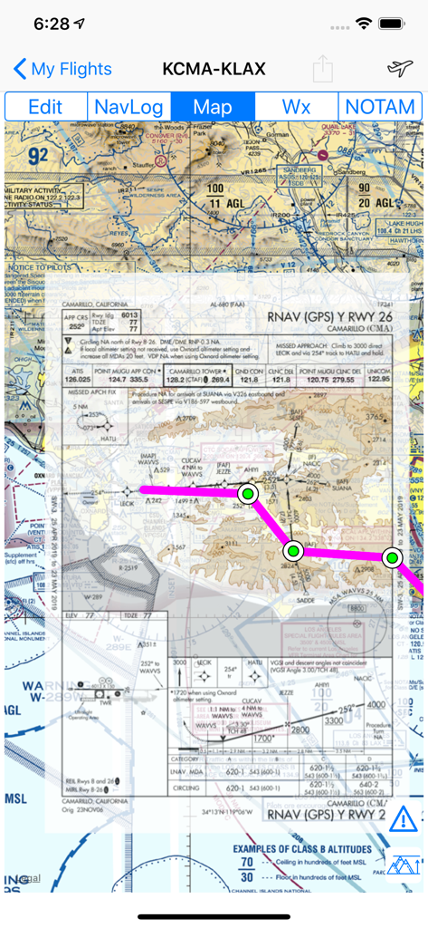
Airmateアプリが、重畳されたFAA計器進入チャートを備えた移動マップを表示しています
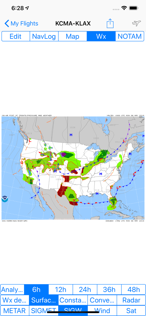
Airmateアプリの表示には、米国全体にわたる前線と気圧システムを示す顕著な天気予報マップが表示されています
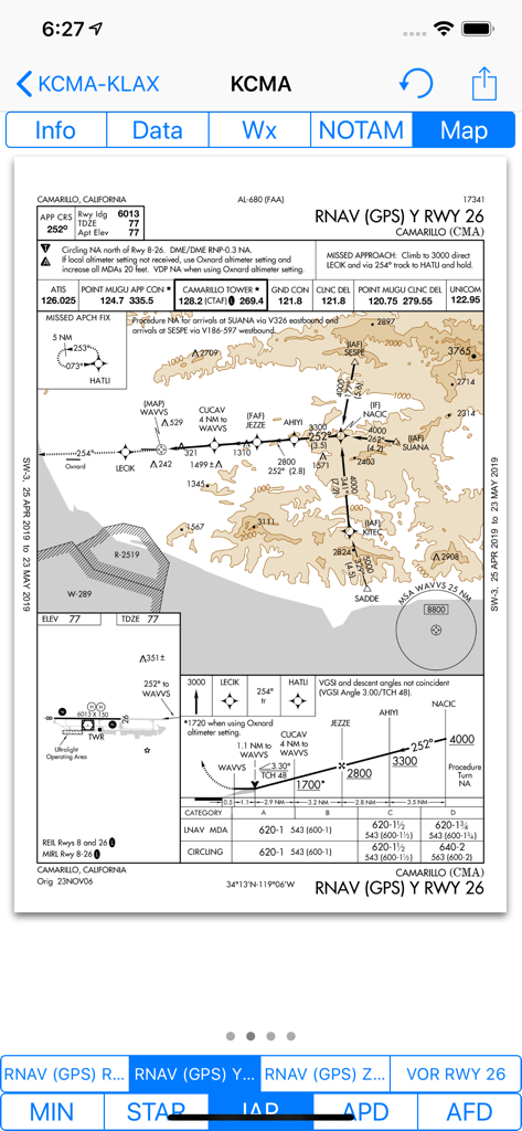
Airmateアプリが、カリフォルニア州カマリロ空港のFAA RNAV GPS計器進入チャートを表示しています
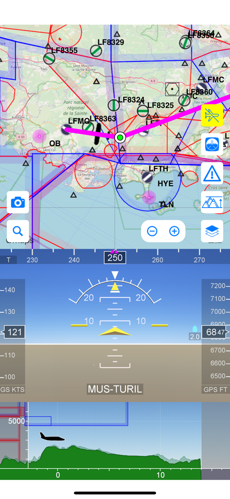
Airmateフライトアプリインターフェースには、移動航空マップ、電子フライト計器、および地形標高プロファイルが搭載されています
説明
Download
類似アプリ
似た機能とユーザー体験を持つアプリ

Navigraph Charts
Navigraph KB

SkyDemon
Divelements Limited

Airports
Applicate Ltd

OzRunways EFB
OzRunways Pty. Ltd.

fDeck: flight instruments
Darren Yeates

Noisy Goose
Automata Solutions Ltd.

StationWeather - METAR and TAF
Oliver Puetz

Drone UAV Fly Forecast: AirMap
MONIQ TAP COMPANY LIMITED

AvPlan EFB
BJA Consulting Pty Ltd
このページはアプリまたはその開発者の公式ページではなく、情報提供および論評を目的として作成された独立した編集出版物です。明示的に別段の記載がない限り、アプリおよびその開発者は、MWM、Apple、Google Play、アプリのパブリッシャー、またはアプリの開発者と提携、承認、後援、認可、またはその他の公式的な関係はなく、このページのいかなる内容も、アプリがMWMのサービスを使用して開発されたことを意味するものではありません。すべての商標、ロゴ、スクリーンショット、その他のコンテンツはそれぞれの所有者の財産です。