このページはアプリまたはその開発者の公式ページではなく、情報提供および論評を目的として作成された独立した編集出版物です。明示的に別段の記載がない限り、アプリおよびその開発者は、MWM、Apple、Google Play、アプリのパブリッシャー、またはアプリの開発者と提携、承認、後援、認可、またはその他の公式的な関係はなく、このページのいかなる内容も、アプリがMWMのサービスを使用して開発されたことを意味するものではありません。すべての商標、ロゴ、スクリーンショット、その他のコンテンツはそれぞれの所有者の財産です。

SkyDemon
ヨーロッパで最も直感的なベクトルチャート、リアルタイムのバーチャルレーダー、そして精密さに焦点を当てたパイロットのために設計されたインテリジェントな安全アラートで、空をマスターしましょう。
ダウンロード
546K+ユーザー評価
評価数
17K+開発元
カテゴリ
Navigation対応言語
-最新バージョン
4.2.3サイズ
55.2 MBリリース日
2012年2月10日比類なき精度で空をマスターする
あなたのiPadをプロフェッショナルグレードの電子フライトバッグに変えましょう。何千人ものパイロットが、すべてのVFRミッションで当社の洗練されたベクトルチャートとリアルタイムの安全ツールを信頼している理由を体験してください。
比類なき視覚的明瞭さ
世界で最も読みやすい航空図を体験してください。動的なベクトルマップは、あらゆるズームレベルで最も関連性の高い空域とナビゲーションデータのみを提供し、雑然さを排除します。
革新的なバーチャルレーダー
完全な状況認識で飛行しましょう。地形、障害物、および制限空域を、到達するずっと前に強調表示する飛行経路の横からの投影を取得します。
よくある質問
について知っておくべきこと SkyDemon
SkyDemonとは何ですか?
SkyDemonは、iOSデバイスでサブスクリプションを通じて利用できる、ヨーロッパで最も利用されているVFRフライトプランニングおよび飛行中ナビゲーションソフトウェアです。
SkyDemonは飛行の危険に対する警告を提供しますか?
はい、SkyDemonは、特定の危険区域を含む、接近する空域、NOTAM、障害物、地形、その他の危険に対するインテリジェントな警告を提供します。
SkyDemonでVFRフライトプランを提出できますか?
はい、SkyDemonを使用すると、ユーザーはルートのVFRフライトプランを航空交通管制官に直接提出できます。
SkyDemonは降雨量データ表示しますか?
はい、SkyDemonは、プランニング中に時間の経過に伴う降雨量の傾向を示す、アニメーション化された降雨量データをメインマップに重ねて表示できます。
SkyDemonはどのようなチャートを使用していますか?
SkyDemonは、ヨーロッパ全域で明確さと可読性を考慮して設計された、動的な空域クリッピングと選択可能なマップレイヤーを備えたベクトルチャートを使用しています。
SkyDemonは飛行中に他の航空機を表示しますか?
はい、SkyDemonは、相対的な位置(例:「前方航空機、11時」)、距離、高度を含む他の航空機へのアラートを表示します。
SkyDemonは気象概況を提供しますか?
SkyDemonは、プランニング中にTAF、METAR、SIGMETのブリーフィングをグラフィカルなデコードとともに自動的に提供します。インターネット接続があれば、飛行中でもライブアップデートが利用可能です。
SkyDemonの地理的範囲は?
はい、SkyDemonは標準で広範なヨーロッパのチャートカバレッジを提供しており、VFRフライトプランニングソフトウェアとしてヨーロッパで最も人気があります。
以下のスクリーンショットと説明は、アプリの公式ストアリスティングから直接取得されたものであり、アプリ開発者の所有物です。
アプリストア
スクリーンショット
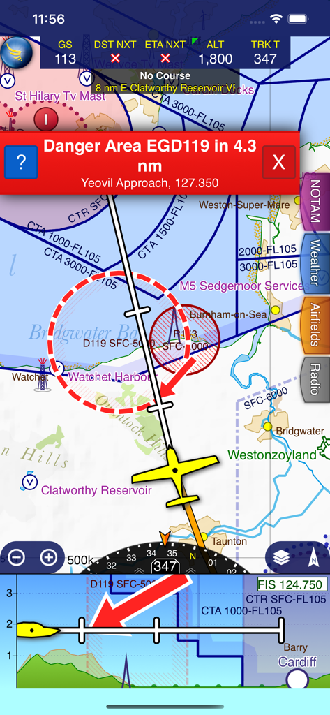
SkyDemonのフライトナビゲーションインターフェース、赤い危険区域の警告とバーチャルレーダーの横からの投影
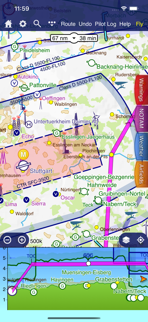
SkyDemonのフライトプランニングインターフェース、ベクトルマップとバーチャルレーダーの横からの投影
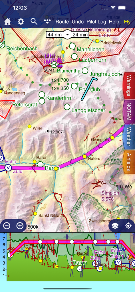
SkyDemon VFRナビゲーションマップとバーチャルレーダーの地形表示
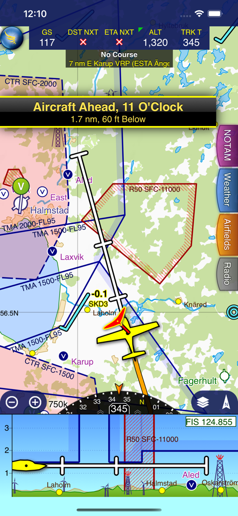
SkyDemonアプリ画面、ベクトルマップ、航空機トラフィックアラート、バーチャルレーダーを備えた飛行中ナビゲーションを表示
説明
Download
類似アプリ
似た機能とユーザー体験を持つアプリ

Navigraph Charts
Navigraph KB

Airports
Applicate Ltd

OzRunways EFB
OzRunways Pty. Ltd.

fDeck: flight instruments
Darren Yeates

Noisy Goose
Automata Solutions Ltd.

StationWeather - METAR and TAF
Oliver Puetz

Drone UAV Fly Forecast: AirMap
MONIQ TAP COMPANY LIMITED

Airmate
Myriel Aviation SA

AvPlan EFB
BJA Consulting Pty Ltd
このページはアプリまたはその開発者の公式ページではなく、情報提供および論評を目的として作成された独立した編集出版物です。明示的に別段の記載がない限り、アプリおよびその開発者は、MWM、Apple、Google Play、アプリのパブリッシャー、またはアプリの開発者と提携、承認、後援、認可、またはその他の公式的な関係はなく、このページのいかなる内容も、アプリがMWMのサービスを使用して開発されたことを意味するものではありません。すべての商標、ロゴ、スクリーンショット、その他のコンテンツはそれぞれの所有者の財産です。