このページはアプリまたはその開発者の公式ページではなく、情報提供および論評を目的として作成された独立した編集出版物です。明示的に別段の記載がない限り、アプリおよびその開発者は、MWM、Apple、Google Play、アプリのパブリッシャー、またはアプリの開発者と提携、承認、後援、認可、またはその他の公式的な関係はなく、このページのいかなる内容も、アプリがMWMのサービスを使用して開発されたことを意味するものではありません。すべての商標、ロゴ、スクリーンショット、その他のコンテンツはそれぞれの所有者の財産です。

AvPlan EFB
FAA認定チャート、リアルタイム気象オーバーレイ、自動飛行計画でコックピットを合理化しましょう。状況認識を向上させ、より早く飛行できるように、パイロットによって設計されています。
ダウンロード
315K+ユーザー評価
評価数
4K+開発元
カテゴリ
Navigation対応言語
2最新バージョン
9.9.8サイズ
218.2 MBリリース日
2011年8月9日あなたの究極のコックピットコンパニオン
AvPlan EFBは、飛行計画から着陸まで、すべてを合理化し、より安全で効率的な旅に必要なプロフェッショナルグレードのツールを提供します。
より迅速な飛行前計画
自動化された飛行モデルエンジンを使用して、FAA準拠の飛行計画、重量とバランス、燃料計算を数分で完了します。
エリートな状況認識
ライブ気象レーダー、地理参照空港図、および積極的な地形とTFRアラートを使用して、自信を持ってナビゲートします。
以下のスクリーンショットと説明は、アプリの公式ストアリスティングから直接取得されたものであり、アプリ開発者の所有物です。
アプリストア
スクリーンショット
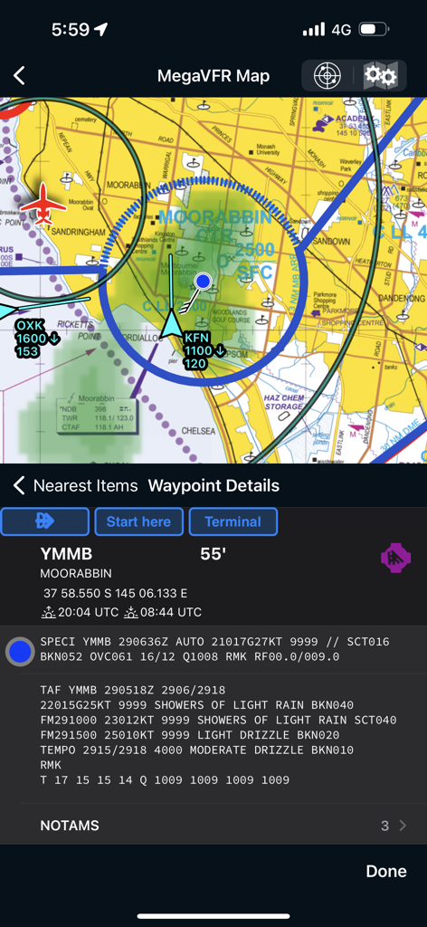
AvPlan EFBナビゲーション画面、航空図と空港の気象詳細を表示
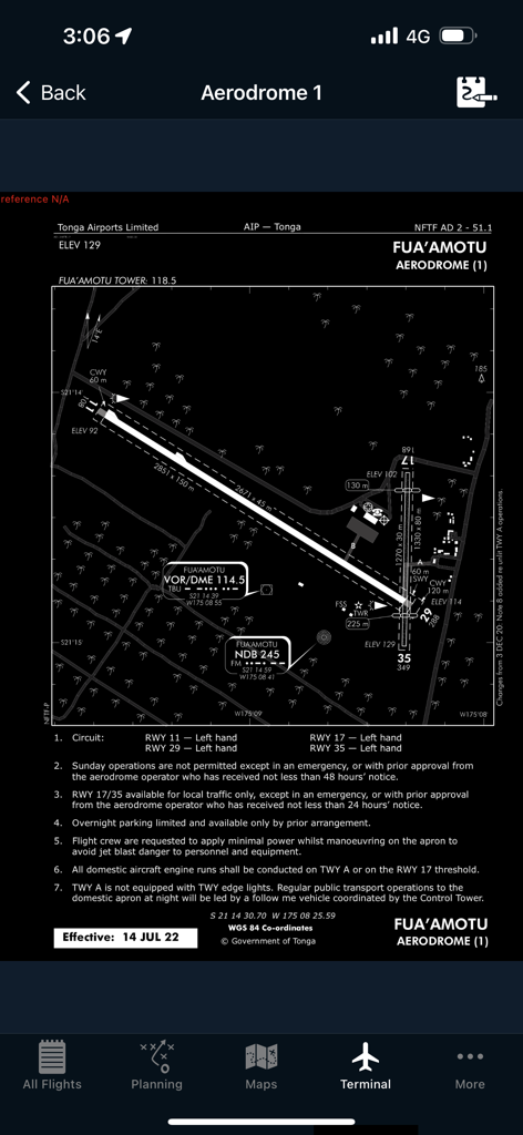
AvPlan EFBターミナルインターフェース内のフアモツ空港の詳細な飛行場図
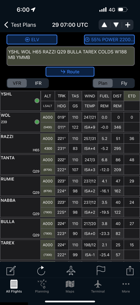
AvPlan EFB飛行計画ログ、ウェイポイントとナビゲーションデータを表示
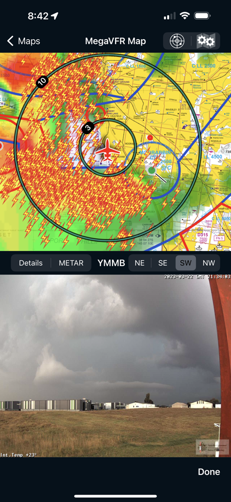
AvPlan EFB分割画面、VFRマップと雷レーダーオーバーレイ、ムーラビン空港のライブカメラフィードを表示
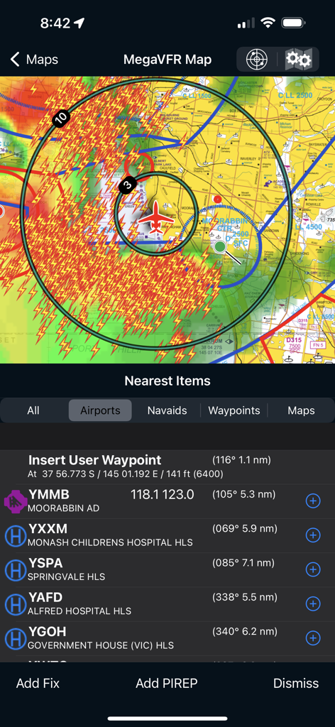
AvPlan EFB飛行ナビゲーション画面、気象レーダーと空港リストを表示
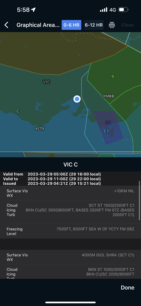
AvPlan EFBグラフィカル気象予報画面、マップと視界の詳細を表示
説明
Download
類似アプリ
似た機能とユーザー体験を持つアプリ

Navigraph Charts
Navigraph KB

SkyDemon
Divelements Limited

Airports
Applicate Ltd

OzRunways EFB
OzRunways Pty. Ltd.

fDeck: flight instruments
Darren Yeates

Noisy Goose
Automata Solutions Ltd.

StationWeather - METAR and TAF
Oliver Puetz

Drone UAV Fly Forecast: AirMap
MONIQ TAP COMPANY LIMITED

Airmate
Myriel Aviation SA
このページはアプリまたはその開発者の公式ページではなく、情報提供および論評を目的として作成された独立した編集出版物です。明示的に別段の記載がない限り、アプリおよびその開発者は、MWM、Apple、Google Play、アプリのパブリッシャー、またはアプリの開発者と提携、承認、後援、認可、またはその他の公式的な関係はなく、このページのいかなる内容も、アプリがMWMのサービスを使用して開発されたことを意味するものではありません。すべての商標、ロゴ、スクリーンショット、その他のコンテンツはそれぞれの所有者の財産です。