このページはアプリまたはその開発者の公式ページではなく、情報提供および論評を目的として作成された独立した編集出版物です。明示的に別段の記載がない限り、アプリおよびその開発者は、MWM、Apple、Google Play、アプリのパブリッシャー、またはアプリの開発者と提携、承認、後援、認可、またはその他の公式的な関係はなく、このページのいかなる内容も、アプリがMWMのサービスを使用して開発されたことを意味するものではありません。すべての商標、ロゴ、スクリーンショット、その他のコンテンツはそれぞれの所有者の財産です。

ダウンロード
1M+ユーザー評価
評価数
80.5K開発元
カテゴリ
Utilities対応言語
49最新バージョン
2.33.0サイズ
85.0 MBリリース日
2016年6月15日プロフェッショナル向けフィールド測定ソリューションの主要機能分析
「GPS Fields Area Measure Map」の技術的評価
オフラインでの高精度な面積・距離測定
本アプリは、インターネット接続がない環境下でも、正確な距離、周囲長、面積の計算を可能にします。これにより、僻地や電波の届かない場所での作業が保証されます。
多様な形式でのデータエクスポート
測定されたデータはKML、KMZ、Shapefile形式でエクスポートできるため、他のGISソフトウェアやプロフェッショナルなツールとの連携が容易です。これにより、既存のワークフローへの統合がスムーズに行われます。
カスタム地図レイヤーの追加
ドローン画像、ラスター地図、WMSサービスなどのカスタム地図レイヤーを追加することで、ユーザーは特定のニーズに合わせて地図の情報を拡張し、より深い分析や計画を行うことができます。
地点ごとの詳細データ記録
地点にメモ、写真、カスタムデータを追加できるため、現場での詳細な情報収集と記録が可能です。これにより、土地管理、検査、問題記録などの多様な用途に対応します。
ワンタップGPS測定とマニュアル編集
GPSによる歩行/運転測定は迅速なデータ収集を可能にし、点マーカーを用いた精密なマニュアル編集は、測定結果の精度を確保します。この組み合わせにより、効率性と正確性が両立されます。
プロジェクトの保存・グループ化・編集
複数のプロジェクトを保存、グループ化、編集できるため、ユーザーは作業を効率的に整理し、管理することができます。これにより、大規模な業務や複数のクライアントに対応する際に役立ちます。
よくある質問
について知っておくべきこと GPS Fields Area Measure Map
Can GPS Fields Area Measure Map function without an internet connection?
Yes, GPS Fields Area Measure Map precisely calculates distance, perimeter, and area even without an internet connection, making it fully operational anywhere.
What measurements can GPS Fields Area Measure Map calculate?
GPS Fields Area Measure Map accurately calculates distance, perimeter, and area. It provides precise measurements for various field and land management applications.
Does GPS Fields Area Measure Map allow adding notes and photos to points?
Yes, GPS Fields Area Measure Map enables users to mark any point with notes, photos, or custom data, supporting detailed documentation for projects.
Who is GPS Fields Area Measure Map designed to help?
GPS Fields Area Measure Map is designed for farmers, agronomists, land surveyors, construction professionals, and real estate teams for field mapping, inspections, and project documentation.
Does GPS Fields Area Measure Map support one-tap GPS measurements?
Yes, GPS Fields Area Measure Map features one-tap GPS walking/driving measurement. This functionality allows for quick and efficient data collection in the field.
Can users precisely edit measurements within GPS Fields Area Measure Map?
Yes, the app provides precise manual editing capabilities using point markers. This ensures high accuracy for all measurements and adjustments within GPS Fields Area Measure Map.
How does GPS Fields Area Measure Map help organize projects?
Users can save, group, and edit projects within GPS Fields Area Measure Map. This feature helps manage multiple projects efficiently and maintain organized map data.
What export formats are supported by GPS Fields Area Measure Map?
GPS Fields Area Measure Map supports export to KML, KMZ, Shapefile, Web link, PDF, Image, GeoJSON, Esri Shapefile, and Satloc (.job) formats for sharing work.
Can custom map layers be added to GPS Fields Area Measure Map?
Yes, users can add custom map layers, including drone imagery, raster maps, or any WMS service, to enhance their field data within GPS Fields Area Measure Map.
Is GPS Fields Area Measure Map free to download?
Yes, GPS Fields Area Measure Map is free to download. Users can unlock advanced tools and cloud storage by upgrading to the Premium version for enhanced features.
What is Hole Mode in GPS Fields Area Measure Map?
Hole Mode in GPS Fields Area Measure Map allows users to refine maps by defining and perfecting holes or irregular internal areas within a measured field, ensuring precise area exclusion.
Can precise coordinates be entered in GPS Fields Area Measure Map?
Yes, GPS Fields Area Measure Map allows users to input precise longitude and latitude coordinates. This ensures points are placed with total accuracy on the map.
以下のスクリーンショットと説明は、アプリの公式ストアリスティングから直接取得されたものであり、アプリ開発者の所有物です。
アプリストア
スクリーンショット
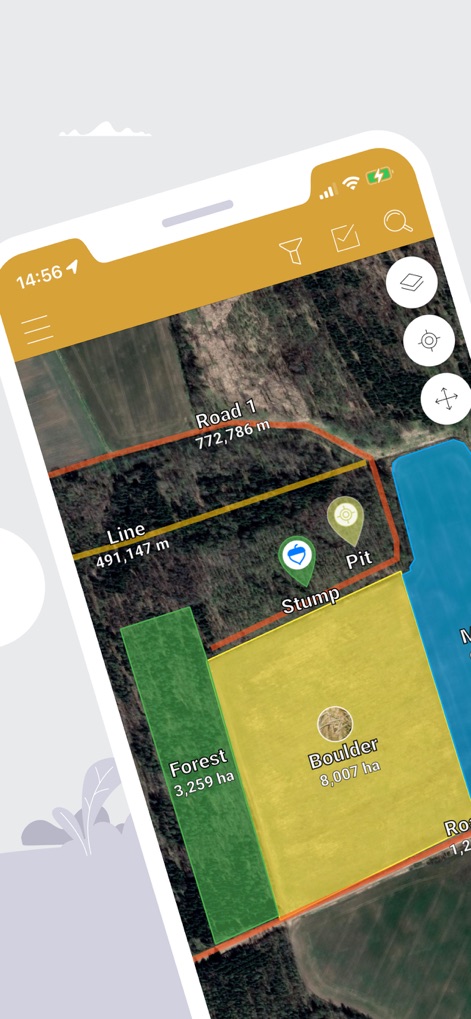
複数のフィールドが色分け表示され、その**面積**と**距離**が正確に測定されている様子を示します。
精密な地図測定
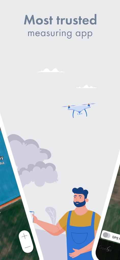
アプリの信頼性と広範な利用を象徴する**ドローン**のイラストと、**ユーザーインターフェースの一部**が視覚的に組み合わされています。
信頼される計測アプリ
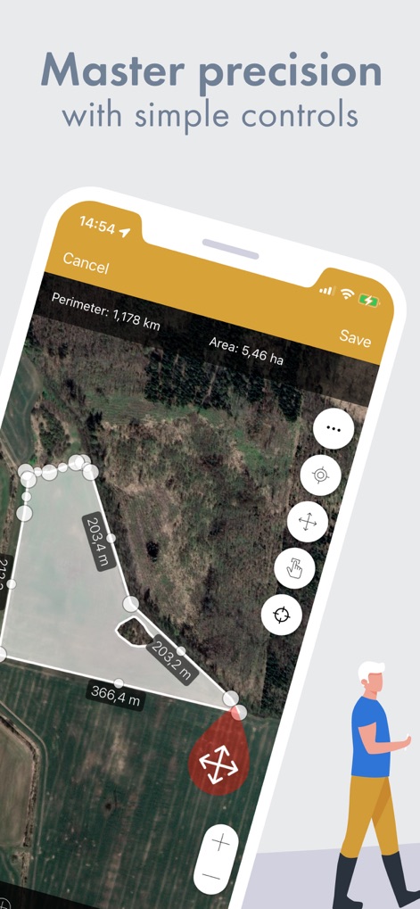
ユーザーが地図上でフィールドの輪郭を**手動で編集**し、**周囲長と面積**をリアルタイムで確認できる機能を示します。
直感的な精度調整
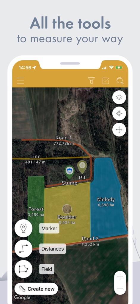
ユーザーが**マーカーの追加**や**距離の計測**など、様々な測定ツールに素早くアクセスできるインターフェースを表示します。
多彩な測定ツール
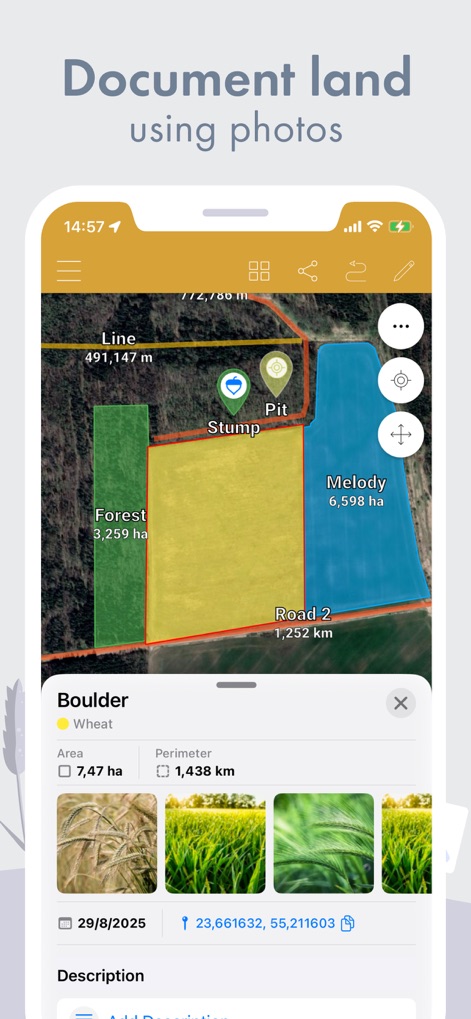
特定のフィールド「Boulder」の**面積や周囲長**に加え、関連する**写真やメモ**を一元的に管理できる機能を示します。
詳細な情報管理
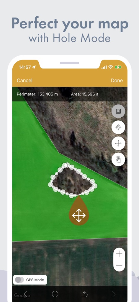
ユーザーがフィールド内に**穴(Hole Mode)**を作成し、複雑な形状のエリアでも正確な**周囲長と面積**を測定できる様子を示します。
複雑な形状も対応
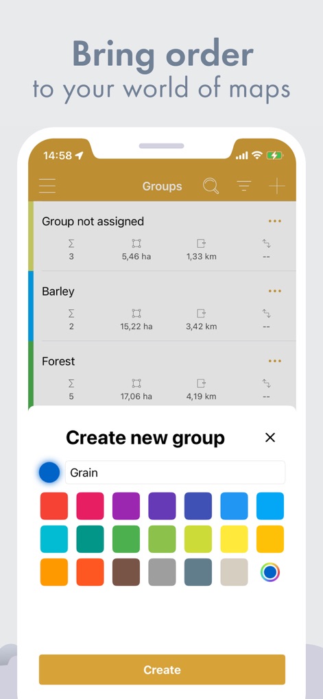
ユーザーが複数の測定データを**グループ分け**して管理し、各グループに**色を割り当てて**視覚的に整理できる機能を示します。
プロジェクトを整理
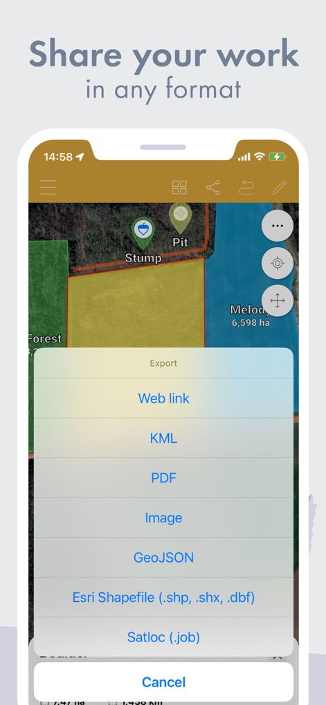
ユーザーは作成した測定データを**KML**や**PDF**など、様々な形式でエクスポートし、他のツールやチームと共有できます。
柔軟なデータ共有
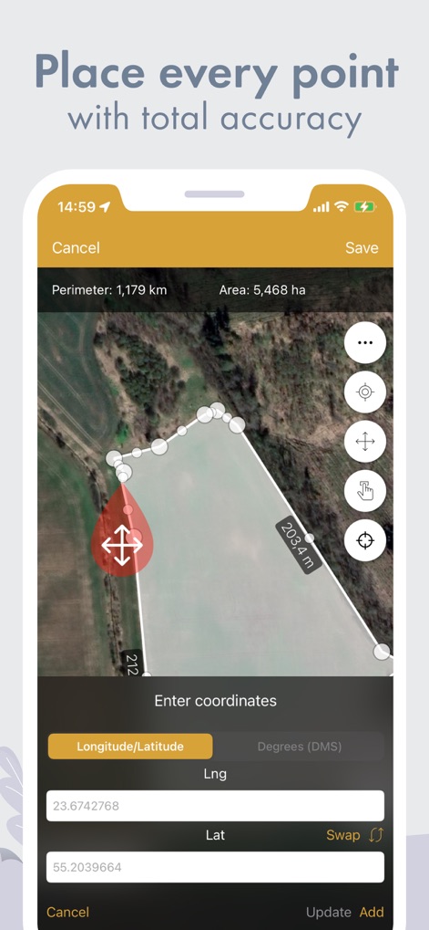
ユーザーがマップ上のポイントを**経度と緯度**で直接指定し、**周囲長と面積**の計算に高い精度を適用できる機能を示します。
高精度な地点設定
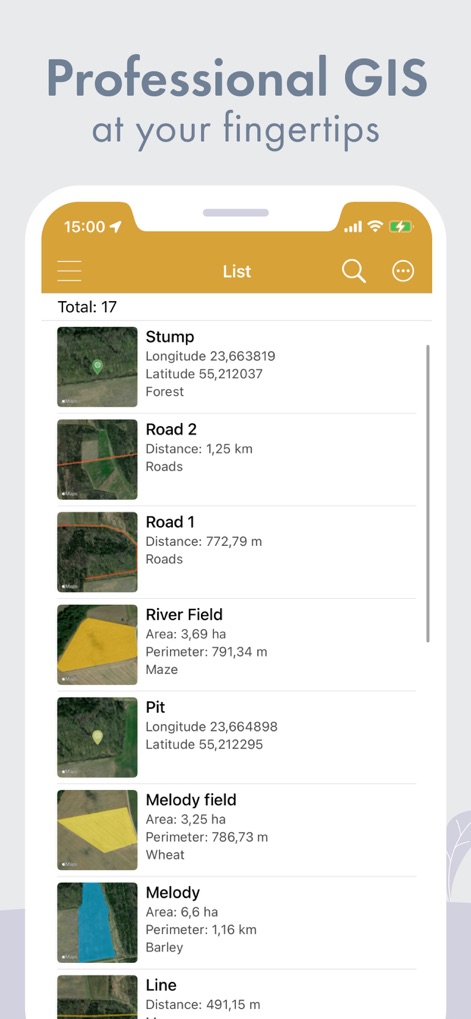
ユーザーが全ての測定データを**リスト形式**で確認でき、各エントリの**ミニマップ表示**と**詳細情報(面積、距離など)**を一目で把握できます。
測定データを一覧
説明
Download
類似アプリ
似た機能とユーザー体験を持つアプリ

Field MapS - Measure Land GPS
Aleksei Metelkin

Field Area MeasureーLand Parcel
Irina Metelkina

FieldCalc - GPS Area Measure
Pravin Gondaliya

Geo Field Area - GPS Measure
STOMBERG s.r.o

GLand: GPS Field Area Measure
Authai Yaprasat

Distance - Find My Distance
Mapnitude Company Limited

Area & Distance - Map Measure
Mapnitude Company Limited

Measure Map
Xuan Luong Do

Field Area Measure
Yaroslav Babenko
このページはアプリまたはその開発者の公式ページではなく、情報提供および論評を目的として作成された独立した編集出版物です。明示的に別段の記載がない限り、アプリおよびその開発者は、MWM、Apple、Google Play、アプリのパブリッシャー、またはアプリの開発者と提携、承認、後援、認可、またはその他の公式的な関係はなく、このページのいかなる内容も、アプリがMWMのサービスを使用して開発されたことを意味するものではありません。すべての商標、ロゴ、スクリーンショット、その他のコンテンツはそれぞれの所有者の財産です。