このページはアプリまたはその開発者の公式ページではなく、情報提供および論評を目的として作成された独立した編集出版物です。明示的に別段の記載がない限り、アプリおよびその開発者は、MWM、Apple、Google Play、アプリのパブリッシャー、またはアプリの開発者と提携、承認、後援、認可、またはその他の公式的な関係はなく、このページのいかなる内容も、アプリがMWMのサービスを使用して開発されたことを意味するものではありません。すべての商標、ロゴ、スクリーンショット、その他のコンテンツはそれぞれの所有者の財産です。

Live Satellite View & GPS Maps
このアプリは、地球のあらゆる場所を上空から支配する力を与える。見慣れた世界が、手のひらで操れる広大な領域へと変貌する。
ダウンロード
100k+ユーザー評価
評価数
1.8K開発元
カテゴリ
Navigation対応言語
1最新バージョン
1.0.7サイズ
89.9 MBリリース日
2024年12月23日テックアナリストによる詳細評価
「Live Satellite View & GPS Maps」の主要機能分析
高解像度リアルタイム衛星画像
このアプリは、世界中のあらゆる場所を高精細な衛星画像で鮮明に表示し、地球の地理を探索することを可能にします。
インタラクティブな地図とナビゲーション
衛星、地形、ハイブリッドなど複数の地図表示をシームレスに切り替えることで、ユーザーは場所の探索やナビゲーションを容易に行うことが可能です。
ライブGPSトラッキング
ライブGPSトラッキング機能により、ユーザーは自身の正確な位置を特定し、ルート計画や周辺の場所の発見に役立てることができます。
オフラインモード
特定の地域をダウンロードすることで、インターネット接続がない環境でも衛星画像にアクセスでき、旅行者やアウトドア愛好家に大きな利便性を提供します。
グローバルカバレッジ
本アプリは、都市部から遠隔地、海洋まで、地球上のあらゆる場所の衛星画像を提供し、ユーザーに広範な地理的探索を可能にします。
衛星レイヤーとカスタマイズ
地形、道路、境界線などの様々なレイヤーを切り替えることで、ユーザーはパーソナライズされた地図体験を得ることができ、より詳細な情報分析が可能です。
過去の画像履歴
過去の衛星画像を閲覧することで、特定の地域が時間とともにどのように変化したかを分析でき、教育目的や不動産分析に役立ちます。
ズームイン/アウト機能
スムーズなズームイン/アウト機能により、ユーザーは大小様々な地理的特徴を詳細に観察することができ、探索の自由度を高めます。
よくある質問
について知っておくべきこと Live Satellite View & GPS Maps
What is the primary function of the Live Satellite View & GPS Maps app?
The Live Satellite View & GPS Maps app provides high-resolution satellite imagery and real-time GPS tracking. It allows users to explore any location on Earth from space using interactive maps and navigation features.
Does Live Satellite View & GPS Maps offer real-time satellite imagery?
Yes, Live Satellite View & GPS Maps offers access to up-to-date satellite images for any location worldwide. This provides vivid, high-resolution details for exploring the Earth.
Can I track my location using the Live Satellite View & GPS Maps app?
Yes, Live Satellite View & GPS Maps includes live GPS tracking. Users can pinpoint their exact location, plan routes, and discover nearby places with this feature.
What types of map views are available in Live Satellite View & GPS Maps?
Live Satellite View & GPS Maps offers interactive map views including satellite, terrain, and hybrid options. Users can seamlessly switch between these views for navigation and exploration.
Does Live Satellite View & GPS Maps have an offline mode?
Yes, Live Satellite View & GPS Maps features an offline mode. Users can download specific regions to access satellite imagery even without an internet connection.
Does the Live Satellite View & GPS Maps app include a Street View feature?
Yes, the Live Satellite View & GPS Maps app includes a Street View feature. Users can find and explore street-level views of various countries and locations.
How can I find nearby places with Live Satellite View & GPS Maps?
Live Satellite View & GPS Maps provides a "Nearby Places" feature. Users can search for various categories such as hospitals, restaurants, ATMs, schools, and more.
Does Live Satellite View & GPS Maps display traffic information?
Yes, Live Satellite View & GPS Maps includes a "Traffic" feature. It provides a traffic locator to show normal, slower than normal, slower, and heavy traffic conditions.
Can Live Satellite View & GPS Maps function as a speedometer?
Yes, Live Satellite View & GPS Maps includes a "Speedometer" feature. It displays current speed in km/h, average speed, max speed, time, and distance.
Is it possible to measure distance using the Live Satellite View & GPS Maps app?
Yes, Live Satellite View & GPS Maps provides an "Area Measurement" feature. Users can select points on the map to calculate the distance or area between them.
以下のスクリーンショットと説明は、アプリの公式ストアリスティングから直接取得されたものであり、アプリ開発者の所有物です。
アプリストア
スクリーンショット
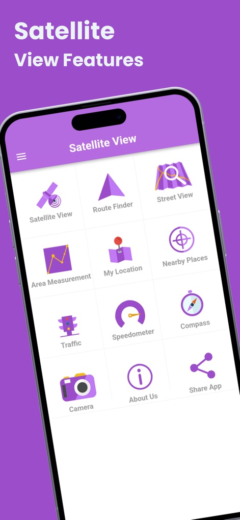
本アプリの包括的な機能メニューは、ルート検索や現在地表示から、スピードメーターやコンパスまで、ユーザーに必要なツールへの迅速なアクセスを提供します。
主要機能一覧

ユーザーは詳細な衛星画像で現在の位置を特定し、地図上のピンで正確な住所と座標を確認できます。
ライブ衛星画像

ストリートビュー機能により、ユーザーは世界中の都市の俯瞰画像を探索し、希望の国を検索してバーチャル旅行を楽しめます。
世界を探索
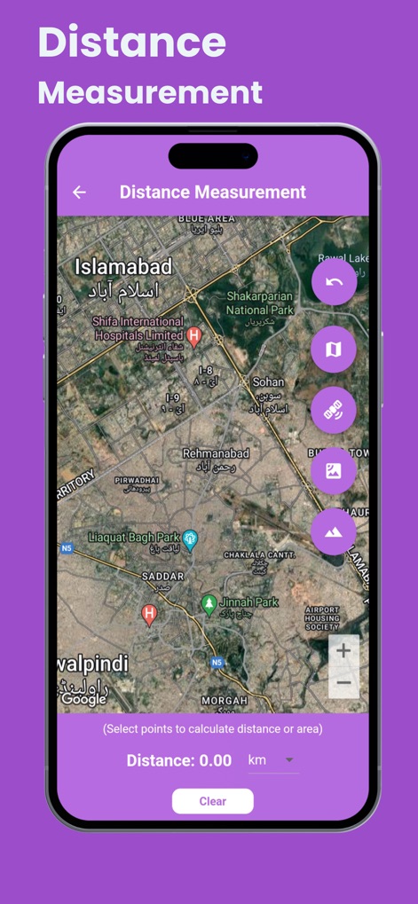
このツールは、地図上で選択した2点間の正確な距離を計算し、ユーザーが地域を分析するための直感的なインターフェースを提供します。
距離測定ツール
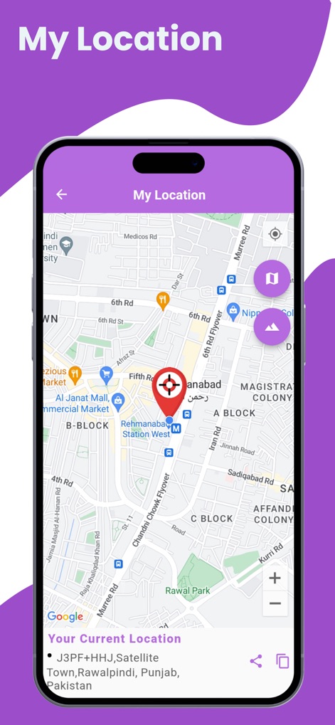
本機能は、詳細な衛星マップ上でユーザーの現在地を正確に表示し、住所とGPS座標を明確に提供します。
現在地を把握
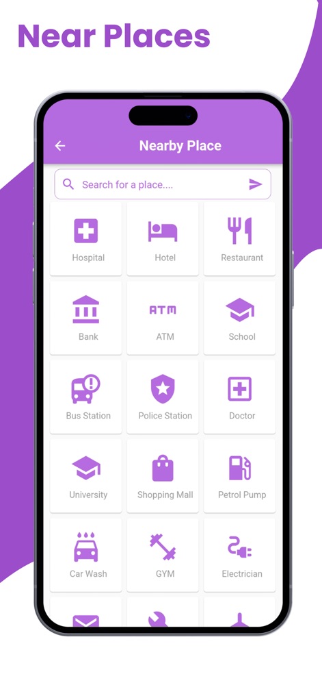
ユーザーは周辺の病院やレストランといった様々なカテゴリーの施設を検索でき、効率的な場所探しを可能にするアイコンベースのメニューが提供されます。
周辺施設検索
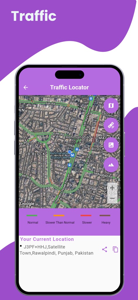
リアルタイムの交通情報が道路上に色分けされたオーバーレイで表示され、現在の交通状況に応じてルート選択をサポートします。
交通情報リアルタイム
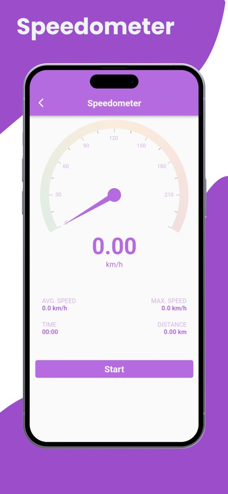
このデジタル速度計は、移動中の現在の速度を正確に表示し、平均速度や最高速度、経過時間などの詳細な運転データを提供します。
デジタル速度計
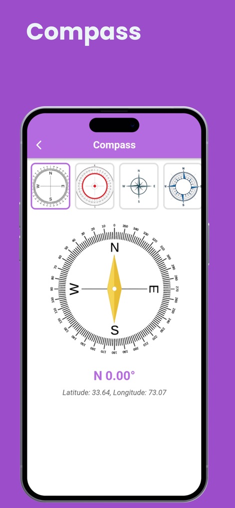
ユーザーは精密なデジタルコンパスで正確な方角を特定でき、緯度と経度の情報も同時に表示されます。
精密コンパス
説明
Download
類似アプリ
似た機能とユーザー体験を持つアプリ

Earth Maps
FOXPOI PTE. LTD.

Satellite Map - Live Earth
慧敏 赵

Satellite Map - Earth View
ANKAGIS YAZILIM ANONIM SIRKETI

World Street 3D Panoramic Map
Beijing Zhiyue Information Technology Co., Ltd

3D Earth Map Street View
Naik Ur Rehman

Globe 3D Earth: World Map Live
Shams Alam

Street View - street view maps
国辉 满

卫星地图-高清地球探索世界
方元 朱

GoGoEarth - Custom map source
大靖 刘
このページはアプリまたはその開発者の公式ページではなく、情報提供および論評を目的として作成された独立した編集出版物です。明示的に別段の記載がない限り、アプリおよびその開発者は、MWM、Apple、Google Play、アプリのパブリッシャー、またはアプリの開発者と提携、承認、後援、認可、またはその他の公式的な関係はなく、このページのいかなる内容も、アプリがMWMのサービスを使用して開発されたことを意味するものではありません。すべての商標、ロゴ、スクリーンショット、その他のコンテンツはそれぞれの所有者の財産です。