このページはアプリまたはその開発者の公式ページではなく、情報提供および論評を目的として作成された独立した編集出版物です。明示的に別段の記載がない限り、アプリおよびその開発者は、MWM、Apple、Google Play、アプリのパブリッシャー、またはアプリの開発者と提携、承認、後援、認可、またはその他の公式的な関係はなく、このページのいかなる内容も、アプリがMWMのサービスを使用して開発されたことを意味するものではありません。すべての商標、ロゴ、スクリーンショット、その他のコンテンツはそれぞれの所有者の財産です。

Satellite Map - Live Earth
指先で地球を支配する。このアプリは単なる地図ではない。未知の世界を解き放つ。自宅から世界中のあらゆる場所へアクセス可能。これぞ究極の地球探索ツールだ。
ダウンロード
2.5M+ユーザー評価
評価数
57.3K開発元
カテゴリ
Navigation対応言語
2最新バージョン
2.5サイズ
63.1 MBリリース日
2020年1月10日テックアナリストによる詳細評価とユーザーメリットの洞察
アプリケーション分析: 'Satellite Map - Live Earth'の主要機能
高解像度衛星地図
本アプリは最新かつ最も完全な衛星地図を提供し、地球の表面を詳細に観察し、地理的な特徴や地形を把握することを可能にします。これにより、グローバルな探索や詳細な地理的洞察に関心のあるユーザーは、自宅にいながらにして世界中の地域を視覚的に体験できます。
リアルタイム座標付き等高線地図
等高線地図上にリアルタイムで座標(緯度経度)を表示することで、アウトドア愛好家や地理学の専門家は、正確な位置データを取得し、地形の起伏を詳細に分析することが可能です。本機能は、精密なマッピングと位置データへのニーズに応えます。
3D地図(建物の3Dモデル表示)
建物の3Dモデルを表示することで、ユーザーは都市景観をよりリアルかつ立体的に体験できます。この機能は、不動産専門家が物件を評価したり、旅行者が目的地のランドマークを事前に確認したりするのに特に有用です。
未知の世界の探索とバーチャル旅行
本アプリは、ユーザーが未知の世界を探索し、自宅にいながらにして世界中の壮大な景色を楽しむことを可能にします。この機能は、旅行への関心を持つ個人や地理愛好家にとって、手軽なバーチャル体験を提供します。
よくある質問
について知っておくべきこと Satellite Map - Live Earth
What is the Satellite Map - Live Earth app?
The Satellite Map - Live Earth app provides HD satellite maps, offering the latest and most complete global satellite imagery. It serves as a companion to explore the world and enjoy global scenery from home.
What types of maps are available in Satellite Map - Live Earth?
Satellite Map - Live Earth offers HD satellite maps, 3D maps displaying building models, contour maps with real-time coordinates, and flat maps showing global street information.
Does Satellite Map - Live Earth show 3D models of buildings?
Yes, Satellite Map - Live Earth includes 3D maps that specifically show 3D models of buildings. This feature enhances exploration by providing a more immersive view.
Does Satellite Map - Live Earth use background location services?
Yes, Satellite Map - Live Earth continues to use the device's location feature in the background. This ensures continuous tracking or updating of location-based data within the app.
Will Satellite Map - Live Earth reduce my phone's battery life?
Yes, Satellite Map - Live Earth's continuous use of the location feature in the background reduces battery life. Users should be aware of this impact on device power consumption.
Can I view global street information using Satellite Map - Live Earth?
Yes, Satellite Map - Live Earth provides flat maps that display global street information. This allows users to view street names and details worldwide, as seen in the app's interface.
Does Satellite Map - Live Earth provide real-time coordinates?
Yes, Satellite Map - Live Earth includes contour maps that show real-time coordinates, including longitude and latitude. This feature is useful for precise location data.
以下のスクリーンショットと説明は、アプリの公式ストアリスティングから直接取得されたものであり、アプリ開発者の所有物です。
アプリストア
スクリーンショット
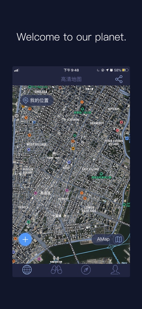
このHD衛星地図は、ユーザーが特定の場所を「私の位置」機能で特定し、詳細な建物の配置と道路網を鮮明に視覚化できます。
世界をリアルに
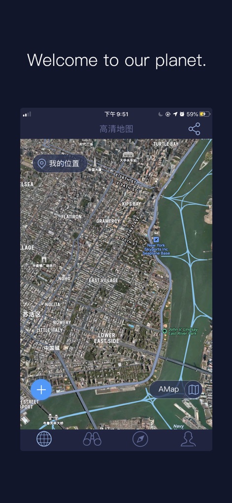
このアプリでは、広大な都市景観を上空から俯瞰でき、主要な水路と複雑に絡み合う街路のパターンを明確に把握できます。
上空からの視点
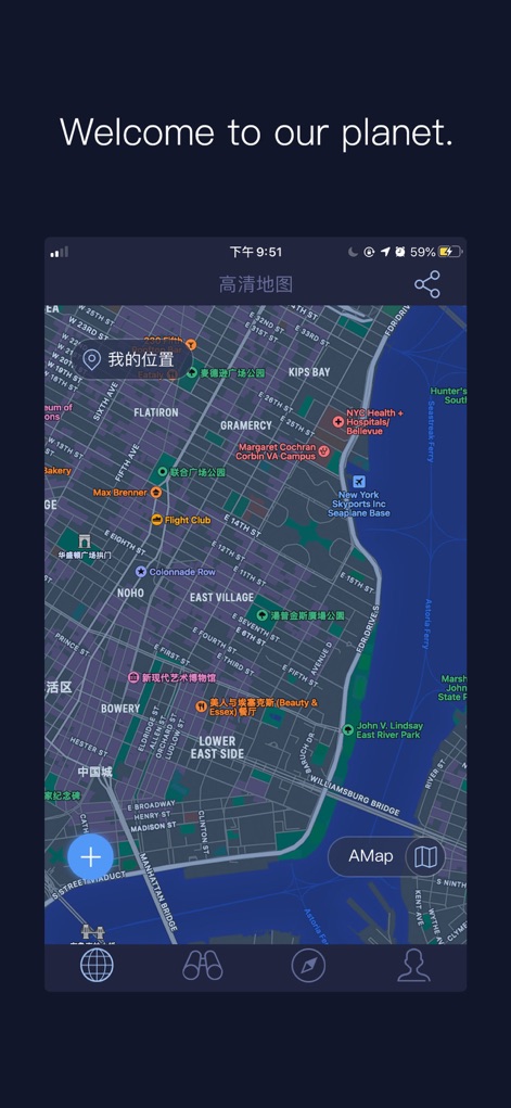
フラットマップビューは、詳細なストリート情報を網羅し、ユーザーが周辺のさまざまなランドマークやポイント・オブ・インタレストを瞬時に発見できます。
地理情報を網羅
説明
Download
類似アプリ
似た機能とユーザー体験を持つアプリ

Earth Maps
FOXPOI PTE. LTD.

Satellite Map - Earth View
ANKAGIS YAZILIM ANONIM SIRKETI

World Street 3D Panoramic Map
Beijing Zhiyue Information Technology Co., Ltd

3D Earth Map Street View
Naik Ur Rehman

Globe 3D Earth: World Map Live
Shams Alam

Street View - street view maps
国辉 满

卫星地图-高清地球探索世界
方元 朱

GoGoEarth - Custom map source
大靖 刘

高清3D街景地图-地图软件手机全景版
Suzhou Caichuang Network Technology Co., Ltd.
このページはアプリまたはその開発者の公式ページではなく、情報提供および論評を目的として作成された独立した編集出版物です。明示的に別段の記載がない限り、アプリおよびその開発者は、MWM、Apple、Google Play、アプリのパブリッシャー、またはアプリの開発者と提携、承認、後援、認可、またはその他の公式的な関係はなく、このページのいかなる内容も、アプリがMWMのサービスを使用して開発されたことを意味するものではありません。すべての商標、ロゴ、スクリーンショット、その他のコンテンツはそれぞれの所有者の財産です。