このページはアプリまたはその開発者の公式ページではなく、情報提供および論評を目的として作成された独立した編集出版物です。明示的に別段の記載がない限り、アプリおよびその開発者は、MWM、Apple、Google Play、アプリのパブリッシャー、またはアプリの開発者と提携、承認、後援、認可、またはその他の公式的な関係はなく、このページのいかなる内容も、アプリがMWMのサービスを使用して開発されたことを意味するものではありません。すべての商標、ロゴ、スクリーンショット、その他のコンテンツはそれぞれの所有者の財産です。
ダウンロード
500k+ユーザー評価
評価数
1.2K開発元
カテゴリ
Navigation対応言語
18最新バージョン
1.4.9サイズ
103.8 MBリリース日
2025年1月2日テックアナリストによる詳細評価と主要機能の解説
アプリ「Satellite Map - Earth View」機能分析
高解像度衛星画像
このアプリは、信じられないほど詳細な高解像度衛星地図を提供し、ユーザーは地球の表面を鮮明に観察できます。
3Dマップと地球儀
本ツールは、インタラクティブな地球儀と地形の視覚化により、ユーザーに地球の3D体験を提供し、没入感のある探索を可能にします。
ストリートビュー
ユーザーは、没入型360度パノラマで通りや地域を探索し、仮想旅行体験を深めることができます。
詳細な拡大表示
このアプリは、風景、ランドマーク、建物を詳細に探索するためにズームインする機能を提供し、きめ細やかな観察を可能にします。
世界中の網羅的なカバー範囲
本ツールは、世界中の都市、大陸、遠隔地を探索できる広範な地理的カバー範囲を備えています。
リアルタイムナビゲーション
ユーザーは、正確なGPSサポートにより自分の位置を確認し、目的地へのナビゲーションを行うことが可能です。
よくある質問
について知っておくべきこと Satellite Map - Earth View
What is Satellite Map - Earth View?
Satellite Map - Earth View is an app providing high-definition 3D satellite imagery, detailed maps, and immersive street views. It allows users to explore the world, navigate, and discover landmarks from their device.
Does Satellite Map - Earth View offer Street View?
Yes, Satellite Map - Earth View offers Street View, allowing users to explore streets and neighborhoods with immersive 360-degree panoramas. This feature enhances virtual exploration.
Can I view Earth in 3D using Satellite Map - Earth View?
Yes, Satellite Map - Earth View provides 3D maps and an interactive globe. Users can experience Earth in 3D with terrain visualization, offering detailed views of landscapes and buildings.
Does Satellite Map - Earth View include a World Atlas?
Yes, Satellite Map - Earth View includes a World Atlas. This feature provides geographical details for countries, capitals, and flags, serving as an educational tool for users.
Is Satellite Map - Earth View free to use?
Yes, Satellite Map - Earth View offers essential features for free. A premium subscription is available to unlock enhanced map providers, additional map styles, and an ad-free experience.
What benefits does a premium subscription for Satellite Map - Earth View offer?
A premium subscription for Satellite Map - Earth View unlocks enhanced map providers, interactive country borders with flag visualization, and additional map styles. It also provides an ad-free experience.
How do I manage my Satellite Map - Earth View subscription?
Users can manage their Satellite Map - Earth View subscription preferences and turn off auto-renewal anytime through their account settings. Subscriptions automatically renew for continued access.
Can I measure areas on the map with Satellite Map - Earth View?
Yes, Satellite Map - Earth View allows users to measure areas on the map. Screenshot #4 demonstrates this functionality by displaying a polygonal selection with an area measurement of 13.98 km².
Where can I find the Privacy Policy for Satellite Map - Earth View?
The Privacy Policy for Satellite Map - Earth View is available at the provided URL: https://www.ankagis.com/satellitemap/privacy/. This document outlines data handling practices.
Does Satellite Map - Earth View support real-time navigation?
Yes, Satellite Map - Earth View supports real-time navigation. The app helps users find their current location and navigate with accurate GPS support for efficient travel.
Can Satellite Map - Earth View display different map styles?
Yes, Satellite Map - Earth View can display different map styles. Users can select various map types, as shown in Screenshot #3, including different visual representations of the Earth's surface.
以下のスクリーンショットと説明は、アプリの公式ストアリスティングから直接取得されたものであり、アプリ開発者の所有物です。
アプリストア
スクリーンショット
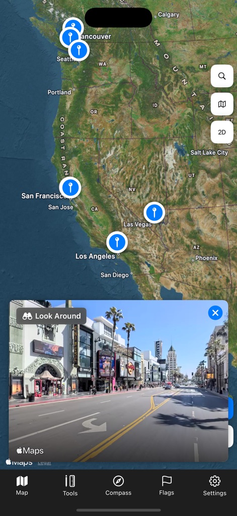
このアプリは、ピン留めされた複数の場所と、特定のエリアの360度パノラマのストリートビューを提供し、没入感のある探索を可能にします。
ストリートビュー探検
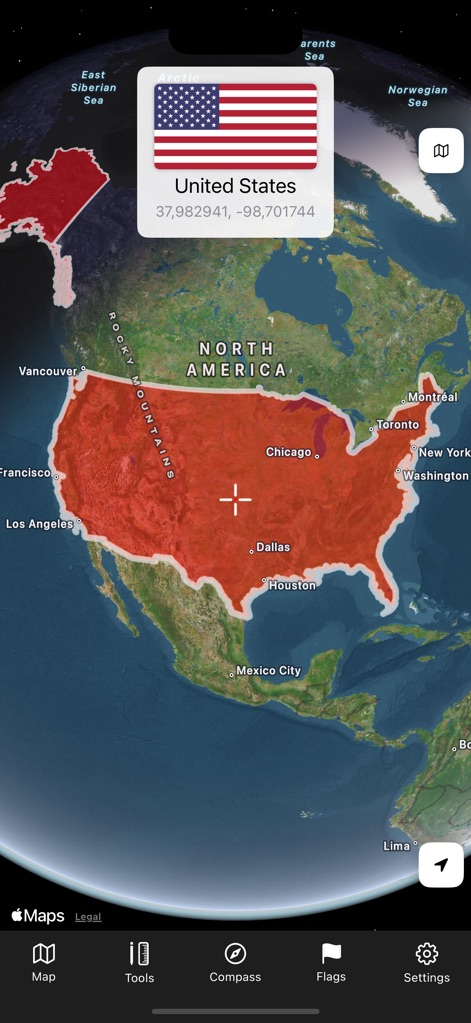
ユーザーは、国境のハイライト表示を通じて各国の地理を視覚的に把握し、国旗情報でその詳細を確認できます。
地球を俯瞰
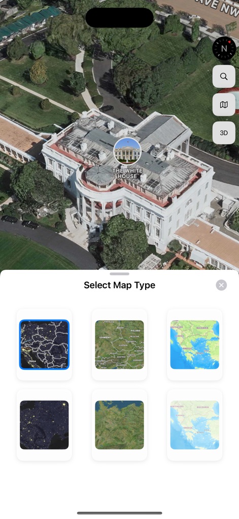
本アプリは、ホワイトハウスのようなランドマークを詳細な3D表示で提供し、ユーザーは複数のマップタイプ選択肢から最適な視覚を選べます。
詳細な3Dモデル
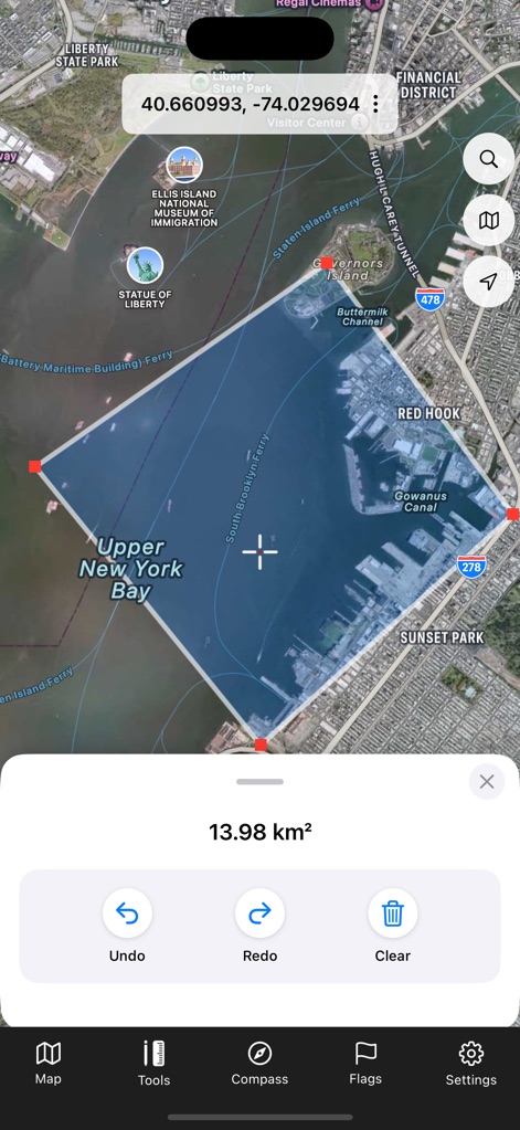
このツールは、特定エリアの面積測定機能と、操作をサポートする元に戻す、やり直すといった複数のツールを提供します。
面積測定ツール
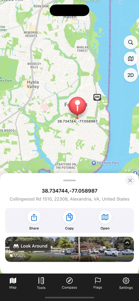
このアプリでは、ピン留めされた場所の緯度経度情報を確認でき、さらにストリートビュープレビューでその場所の様子を事前に把握できます。
正確な位置特定
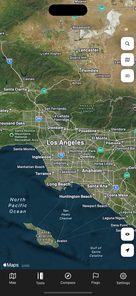
ユーザーは、ロサンゼルスの詳細な衛星画像を通じて都市の広がりを体験し、自然地形の表現によって地理的特徴を理解できます。
広大な地域を探索
説明
Download
類似アプリ
似た機能とユーザー体験を持つアプリ

Earth Maps
FOXPOI PTE. LTD.

Satellite Map - Live Earth
慧敏 赵

World Street 3D Panoramic Map
Beijing Zhiyue Information Technology Co., Ltd

3D Earth Map Street View
Naik Ur Rehman

Globe 3D Earth: World Map Live
Shams Alam

Street View - street view maps
国辉 满

卫星地图-高清地球探索世界
方元 朱

GoGoEarth - Custom map source
大靖 刘

高清3D街景地图-地图软件手机全景版
Suzhou Caichuang Network Technology Co., Ltd.
このページはアプリまたはその開発者の公式ページではなく、情報提供および論評を目的として作成された独立した編集出版物です。明示的に別段の記載がない限り、アプリおよびその開発者は、MWM、Apple、Google Play、アプリのパブリッシャー、またはアプリの開発者と提携、承認、後援、認可、またはその他の公式的な関係はなく、このページのいかなる内容も、アプリがMWMのサービスを使用して開発されたことを意味するものではありません。すべての商標、ロゴ、スクリーンショット、その他のコンテンツはそれぞれの所有者の財産です。