このページはアプリまたはその開発者の公式ページではなく、情報提供および論評を目的として作成された独立した編集出版物です。明示的に別段の記載がない限り、アプリおよびその開発者は、MWM、Apple、Google Play、アプリのパブリッシャー、またはアプリの開発者と提携、承認、後援、認可、またはその他の公式的な関係はなく、このページのいかなる内容も、アプリがMWMのサービスを使用して開発されたことを意味するものではありません。すべての商標、ロゴ、スクリーンショット、その他のコンテンツはそれぞれの所有者の財産です。

Measure Map Pro
エンジニア、請負業者、土地所有者向けの究極のマッピングユーティリティ。地球の曲率精度で複雑な周囲長と面積を計算し、AutoCAD、KML、GIS形式に即座にエクスポートできます。
ダウンロード
99K+ユーザー評価
評価数
2K+開発元
カテゴリ
Utilities対応言語
10最新バージョン
13.10.5サイズ
239.0 MBリリース日
2011年6月22日手のひらの中のプロフェッショナルマッピング
高解像度衛星技術でメジャーを置き換えましょう。モバイルデバイスから直接正確な面積、周囲長、距離を計算することで、現場訪問の時間を節約できます。
レーザーのような正確な測定
小さな建物のフットプリントから広大な1000エーカーの牧場まで、サブメーター精度で測定しながら地球の曲率を考慮します。
業界標準のエクスポート
データ(DXF、SHP、KML、CSV)をAutoCADに即座にエクスポートし、フィールド測定をプロフェッショナルCADまたはGISワークフローにシームレスに統合します。
以下のスクリーンショットと説明は、アプリの公式ストアリスティングから直接取得されたものであり、アプリ開発者の所有物です。
アプリストア
スクリーンショット
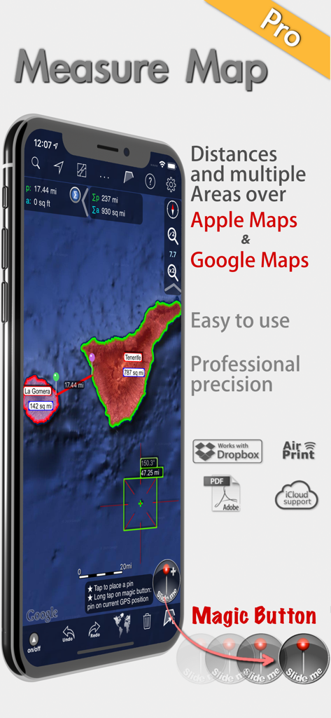
Measure Map Proアプリが衛星マップ上でプロフェッショナルな面積と距離の測定を表示
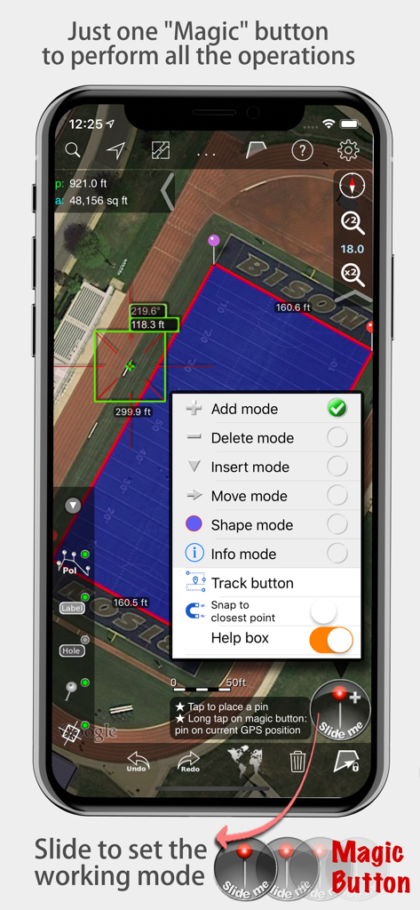
Measure Map Proアプリが衛星マップ上に面積と距離の測定を表示し、マジックボタンメニューを開いた状態
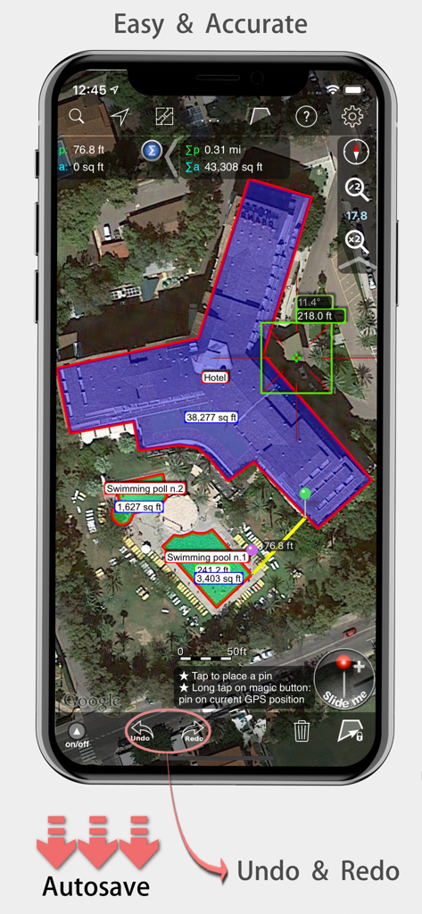
Measure Map Proモバイルアプリが衛星マップ上でホテルの建物の正確な面積と距離の測定を表示
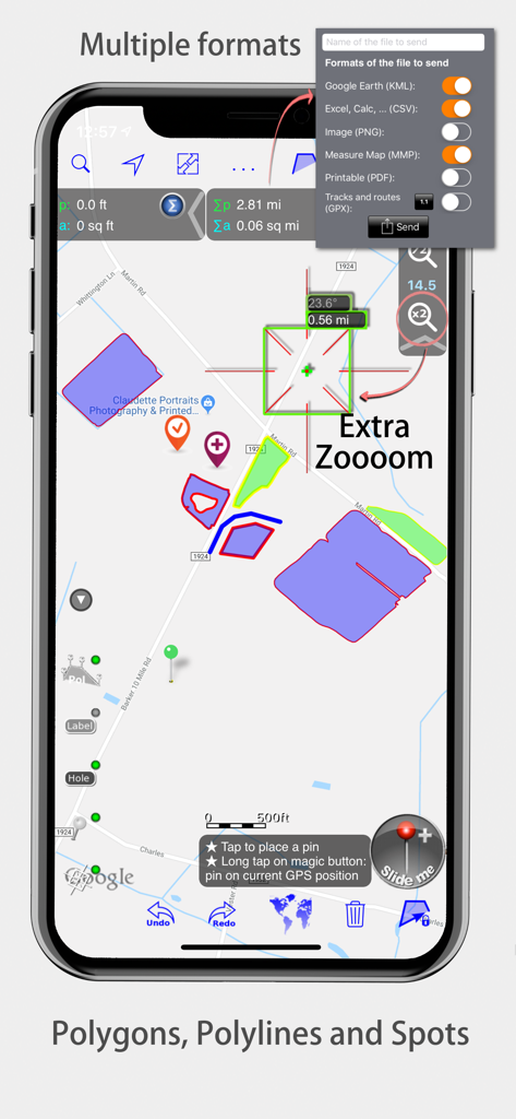
Measure Map Proインターフェイスがマップポリゴンとエクスポート形式を表示
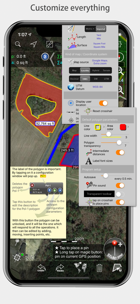
Measure Map Proモバイルアプリインターフェイスが測定とマップスタイルのためのさまざまなカスタマイズメニューを表示
説明
Download
類似アプリ
似た機能とユーザー体験を持つアプリ

Field MapS - Measure Land GPS
Aleksei Metelkin

Field Area MeasureーLand Parcel
Irina Metelkina

FieldCalc - GPS Area Measure
Pravin Gondaliya

GPS Fields Area Measure Map
Rento UAB

Geo Field Area - GPS Measure
STOMBERG s.r.o

GLand: GPS Field Area Measure
Authai Yaprasat

Distance - Find My Distance
Mapnitude Company Limited

Area & Distance - Map Measure
Mapnitude Company Limited

Measure Map
Xuan Luong Do
このページはアプリまたはその開発者の公式ページではなく、情報提供および論評を目的として作成された独立した編集出版物です。明示的に別段の記載がない限り、アプリおよびその開発者は、MWM、Apple、Google Play、アプリのパブリッシャー、またはアプリの開発者と提携、承認、後援、認可、またはその他の公式的な関係はなく、このページのいかなる内容も、アプリがMWMのサービスを使用して開発されたことを意味するものではありません。すべての商標、ロゴ、スクリーンショット、その他のコンテンツはそれぞれの所有者の財産です。