이 페이지는 앱이나 개발자의 공식 페이지가 아니며, 정보 제공 및 논평을 목적으로 작성된 독립 편집 간행물입니다. 명시적으로 달리 언급되지 않는 한, 해당 앱이나 개발자는 MWM, Apple, Google Play, 앱 퍼블리셔 또는 앱 개발자와 제휴, 보증, 후원, 승인 또는 공식적으로 연결되어 있지 않으며, 이 페이지의 어떤 내용도 해당 앱이 MWM의 서비스를 사용하여 개발되었음을 의미하지 않습니다. 모든 상표, 로고, 스크린샷 및 기타 콘텐츠는 해당 소유자의 자산입니다.

FieldCalc - GPS Area Measure
2백만 명 이상의 농부, 측량사 및 부동산 전문가들이 FieldCalc를 신뢰하는 높은 정확도의 에이커 계산 및 경계 매핑에 동참하세요.
다운로드
2M+사용자 평점
총 평가 수
30K+개발사
카테고리
Utilities지원 언어
1최신 버전
5.8크기
217.7 MB출시일
2017년 6월 1일전문가 수준의 토지 측정
FieldCalc는 휴대폰을 정밀 매핑 도구로 바꿔주어 에이커를 계산하고, 둘레를 계획하며, 토지 프로젝트를 완벽하게 자신 있게 관리할 수 있도록 도와줍니다.
고정밀 GPS 매핑
실시간 GPS 추적 또는 대화형 위성 지도를 사용하여 전문가 수준의 정확도로 모든 밭이나 경계선을 측정하세요.
에이커 및 자재 추정
총 에이커 면적을 즉시 계산하여 씨앗, 비료 또는 울타리 예산을 최적화하고, 재고를 초과 주문하는 일이 없도록 하세요.
자주 묻는 질문
에 대해 알아야 할 모든 것 FieldCalc - GPS Area Measure
FieldCalc은 무엇인가요?
FieldCalc는 정확한 면적 및 거리 계산을 위한 GPS 기반 도구입니다. 농부, 측량사, 부동산 중개인 및 주택 소유자를 위해 정확하고 쉽게 토지, 들판 또는 마당을 측정하도록 설계되었습니다.
FieldCalc로 GPS를 사용하여 토지 면적을 측정할 수 있나요?
네, FieldCalc에는 GPS 필드 면적 측정 도구가 있습니다. 이를 통해 사용자는 지도상의 지점을 선택하여 모든 토지 또는 부동산의 면적을 쉽게 측정할 수 있으며, 들판, 농장 또는 필지에 대한 높은 정확도를 제공합니다.
FieldCalc는 거리 측정 도구를 제공하나요?
네, FieldCalc에는 거리 도구가 포함되어 있습니다. 지도상의 여러 지점 간의 거리를 빠르게 계산합니다. 이 기능은 도로, 산책로를 측정하거나 실시간 추적 및 정밀도로 경로를 계획하는 데 적합합니다.
FieldCalc는 면적 계산에 어떤 단위를 지원하나요?
FieldCalc의 면적 계산기는 측정된 토지 면적을 에이커, 헥타르, 제곱미터 및 기타 단위로 쉽게 변환합니다. 이를 통해 사용자는 선호하는 형식으로 부동산 크기를 쉽게 이해할 수 있습니다.
사용자는 FieldCalc로 지도에 모양을 그릴 수 있나요?
네, FieldCalc는 지도 그리기 기능을 제공합니다. 사용자는 위성 지도에 직접 모양을 그리거나 사용자 지정 경계를 표시할 수 있습니다. 이는 필지, 구역 또는 경로를 시각적으로 윤곽을 잡으며 계획 또는 부동산 시각화에 적합합니다.
FieldCalc는 둘레 측정을 계산하나요?
네, FieldCalc는 선택한 영역 또는 토지 구획의 총 경계 길이를 정확하게 계산합니다. 이 둘레 측정 기능은 사용자가 몇 번의 탭만으로 울타리, 파이프 또는 관개 요구 사항을 추정하는 데 도움이 됩니다.
FieldCalc로 원형 영역을 측정하는 방법이 있나요?
네, FieldCalc는 원형 측정을 제공합니다. 이 고급 기능은 지도에 반경 지점을 배치하여 원형 또는 곡선 영역을 측정합니다. 깔끔한 레이아웃의 정원, 둥근 들판 또는 탱크에 이상적입니다.
FieldCalc는 측정에서 제외된 영역을 어떻게 처리하나요?
FieldCalc에는 영역 빼기 기능이 포함되어 있습니다. 사용자는 한 영역에서 다른 영역을 빼서 사용 가능한 토지 또는 비어 있는 공간을 찾을 수 있습니다. 이는 제외된 구역, 건물 또는 측정 불가능한 부분을 계산하는 데 적합합니다.
FieldCalc에 나침반이 있나요?
네, FieldCalc에는 위성 나침반이 통합되어 있습니다. 사용자는 지도상에서 자신의 위치를 정확하게 탐색하여 내장 도구를 사용하여 넓은 들판이나 낯선 지역에서 자신 있게 방향을 잡는 데 도움이 됩니다.
FieldCalc는 이동 속도를 추적할 수 있나요?
네, FieldCalc에는 속도계가 포함되어 있습니다. 측정하거나 토지 경계를 걷는 동안 실시간으로 이동 속도를 추적합니다. 이는 속도를 모니터링하거나 경로를 계획하거나 현장 측량 활동에 유용합니다.
FieldCalc 앱은 누가 사용하나요?
FieldCalc는 농부, 측량사, 부동산 평가사, 건축업자, 부동산 전문가, 하이커 및 모험가를 위한 것입니다. 빠르고 정확한 토지 또는 거리 측정이 필요한 모든 사람을 돕습니다.
FieldCalc에서 측정값을 저장할 수 있나요?
네, FieldCalc를 사용하면 사용자가 측정값을 저장할 수 있습니다. 또한 이메일, 문자 또는 소셜 미디어를 통해 측정값을 공유하여 편리한 협업 및 기록 보관을 가능하게 합니다.
FieldCalc의 측정 정확도는 어느 정도인가요?
FieldCalc는 전문적인 정확도를 제공합니다. 수백만 명의 측량사, 농부 및 계약자가 정확한 GPS 기반 계산 방법으로 보장되는 빠르고 안정적인 토지 측정에 이 앱을 신뢰합니다.
FieldCalc 지원은 어디에서 찾을 수 있나요?
사용자는 https://fieldcalc.app/contact-us 의 공식 연락 페이지를 방문하여 FieldCalc의 도움말 및 지원을 찾을 수 있습니다.
FieldCalc의 개인정보처리방침이 있나요?
네, FieldCalc는 개인정보처리방침을 유지합니다. 사용자는 https://fieldcalc.app/privacy-policy 에서 데이터 처리 및 개인정보 보호 관행에 대한 세부 정보를 검토할 수 있습니다.
다음 스크린샷과 설명은 앱의 공식 스토어 목록에서 직접 가져온 것이며 앱 개발자의 자산입니다.
앱 스토어
스크린샷

FieldCalc 앱 인터페이스, GPS 토지 면적 측정 및 토지 매핑 시연.
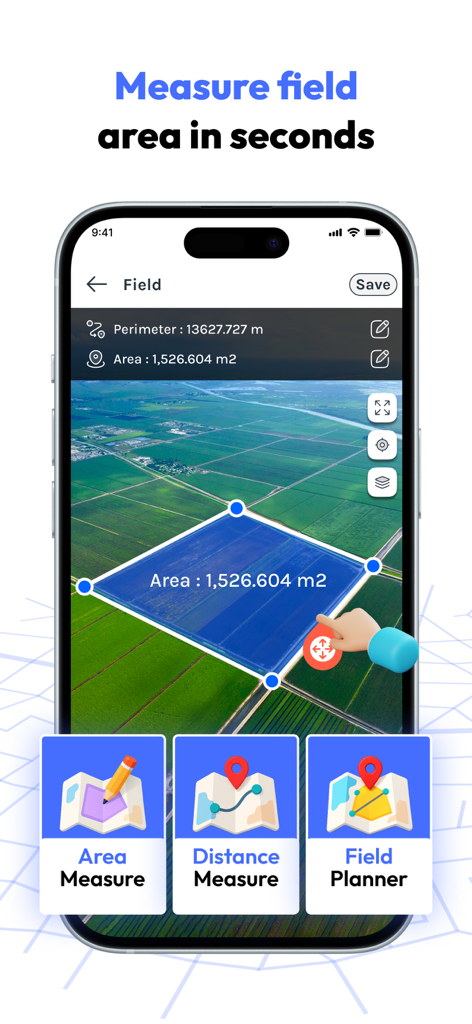
FieldCalc 앱, 농부 및 부동산을 위한 위성 지도에서 토지 면적 측정 중.
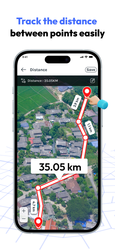
FieldCalc 앱, 위성 지도에서 여러 지점 간의 거리를 측정하는 스마트폰 화면.
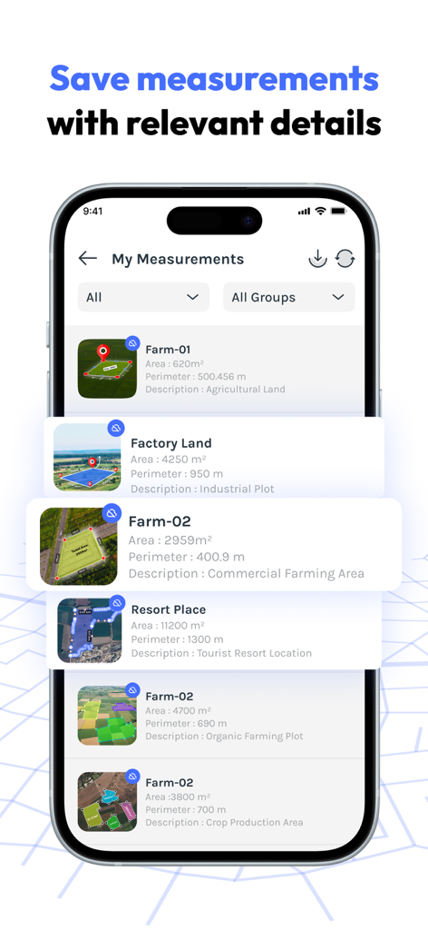
면적 및 둘레 세부 정보가 있는 저장된 GPS 토지 측정 목록을 표시하는 모바일 앱 화면.
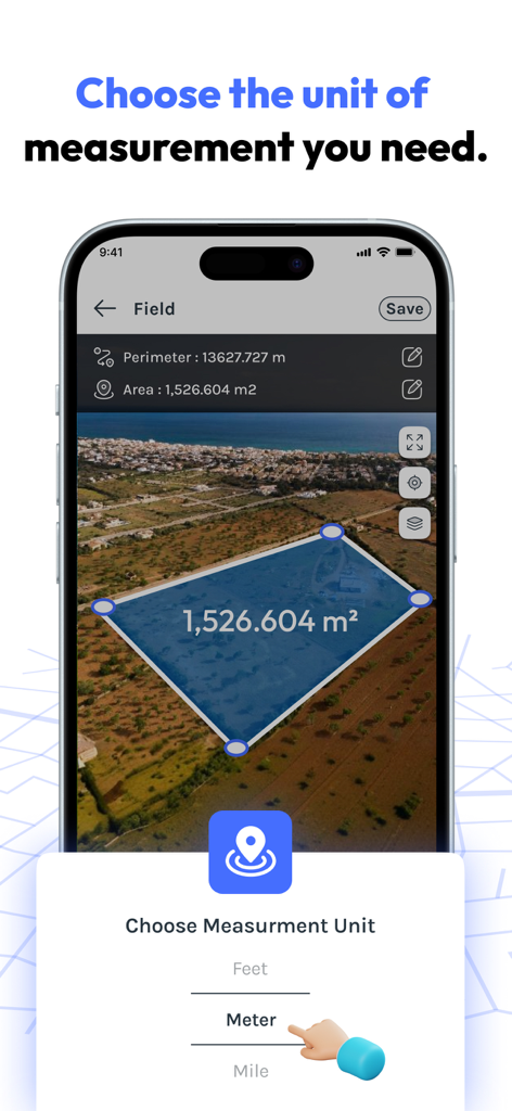
FieldCalc 앱 인터페이스, 측정 단위 선택기가 있는 위성 지도에서 토지 면적 측정 표시 중.
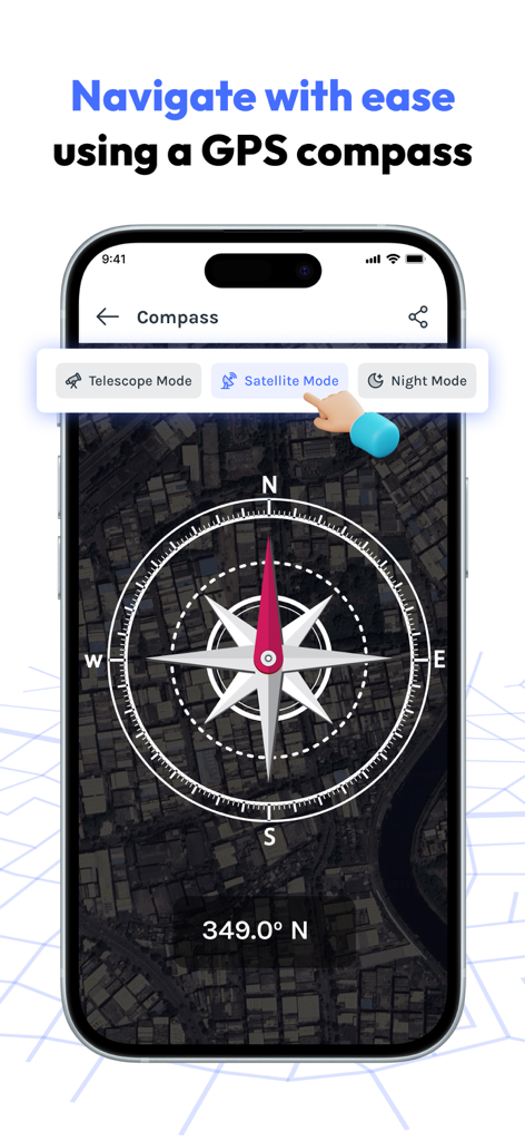
FieldCalc 앱의 위성 지도 배경이 있는 디지털 GPS 나침반.
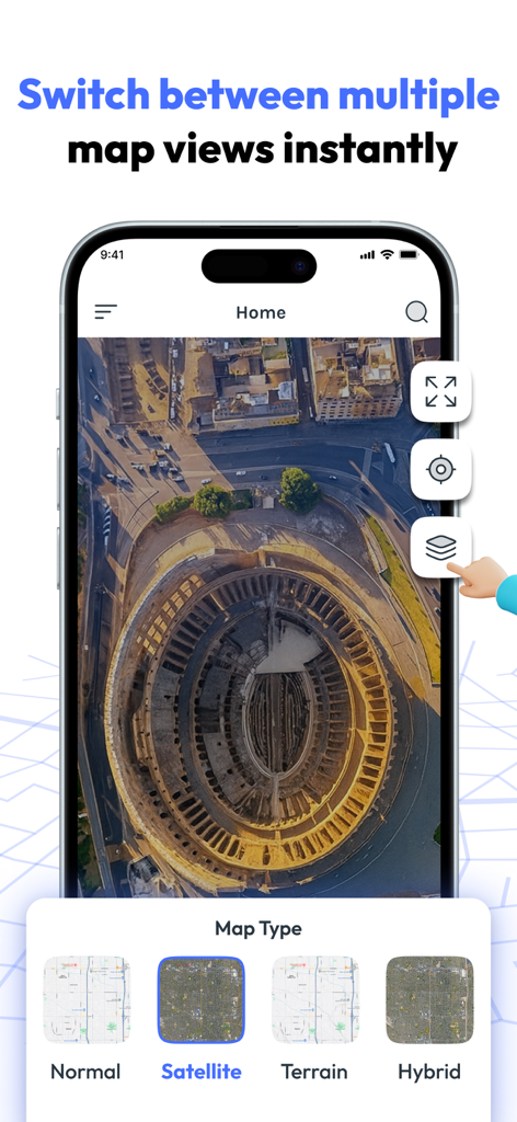
FieldCalc 앱 인터페이스, 위성 지도 보기와 지형 및 하이브리드와 같은 다양한 지도 유형 표시 중.
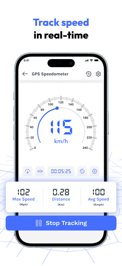
FieldCalc 앱 GPS 속도계 인터페이스, 실시간 속도 및 거리 추적 표시 중.
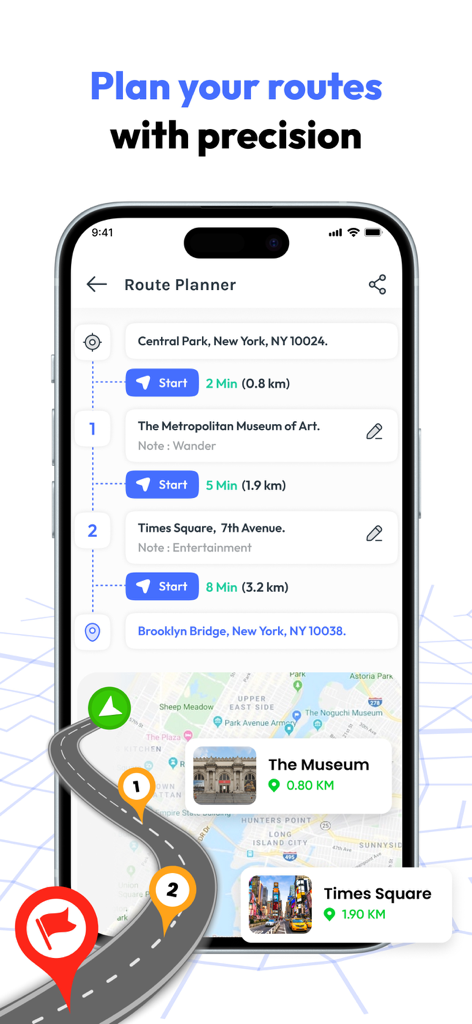
FieldCalc 앱, 여러 지도 마커 및 거리 계산을 사용하여 경로를 계획하는 인터페이스.
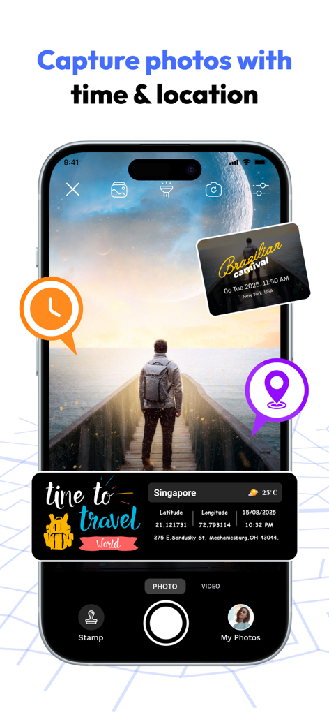
FieldCalc 앱 인터페이스, 통합 GPS 좌표 및 타임스탬프가 있는 사진 캡처 표시 중.
설명
Download
비슷한 앱
유사한 기능과 사용자 경험을 가진 앱

Field MapS - Measure Land GPS
Aleksei Metelkin

Field Area MeasureーLand Parcel
Irina Metelkina

GPS Fields Area Measure Map
Rento UAB

Geo Field Area - GPS Measure
STOMBERG s.r.o

GLand: GPS Field Area Measure
Authai Yaprasat

Distance - Find My Distance
Mapnitude Company Limited

Area & Distance - Map Measure
Mapnitude Company Limited

Measure Map
Xuan Luong Do

Field Area Measure
Yaroslav Babenko
이 페이지는 앱이나 개발자의 공식 페이지가 아니며, 정보 제공 및 논평을 목적으로 작성된 독립 편집 간행물입니다. 명시적으로 달리 언급되지 않는 한, 해당 앱이나 개발자는 MWM, Apple, Google Play, 앱 퍼블리셔 또는 앱 개발자와 제휴, 보증, 후원, 승인 또는 공식적으로 연결되어 있지 않으며, 이 페이지의 어떤 내용도 해당 앱이 MWM의 서비스를 사용하여 개발되었음을 의미하지 않습니다. 모든 상표, 로고, 스크린샷 및 기타 콘텐츠는 해당 소유자의 자산입니다.