이 페이지는 앱이나 개발자의 공식 페이지가 아니며, 정보 제공 및 논평을 목적으로 작성된 독립 편집 간행물입니다. 명시적으로 달리 언급되지 않는 한, 해당 앱이나 개발자는 MWM, Apple, Google Play, 앱 퍼블리셔 또는 앱 개발자와 제휴, 보증, 후원, 승인 또는 공식적으로 연결되어 있지 않으며, 이 페이지의 어떤 내용도 해당 앱이 MWM의 서비스를 사용하여 개발되었음을 의미하지 않습니다. 모든 상표, 로고, 스크린샷 및 기타 콘텐츠는 해당 소유자의 자산입니다.

GPS Fields Area Measure Map
이 앱은 사용자에게 지형을 손끝으로 제어하는 능력을 부여합니다. 복잡한 지도를 측정하고 분석하는 능력을 잠금 해제합니다. GPS Fields Area Measure Map은 현장 작업을 단순화하는 도구가 아닙니다. 이는 사용자를 현장 데이터의 지배자로 만듭니다.
다운로드
1M+사용자 평점
총 평가 수
80.5K개발사
카테고리
Utilities지원 언어
49최신 버전
2.33.0크기
85.0 MB출시일
2016년 6월 15일'GPS Fields Area Measure Map' 애플리케이션의 핵심 기능 및 전문적 활용 분석
소프트웨어 분석가 관점: GPS Fields Area Measure Map
완전 오프라인 기능
이 앱은 인터넷 연결 없이도 모든 측정 및 데이터 수집 작업을 수행할 수 있도록 지원합니다. 이는 원격지 또는 신호가 약한 환경에서 작업하는 전문가들에게 필수적입니다.
정확한 면적 및 거리 측정
이 도구는 사용자가 GPS를 활용하거나 수동으로 지점을 지정하여 필드, 토지 또는 프로젝트 영역의 정확한 면적, 둘레 및 거리를 계산할 수 있게 해줍니다.
정교한 포인트 마킹 및 데이터 주석
사용자는 지점에 메모, 사진 또는 맞춤 데이터를 추가하여 특정 위치에 대한 풍부하고 상세한 정보를 기록하고 관리할 수 있습니다.
다양한 GPS 측정 모드
이 앱은 '원탭 GPS 걷기/운전 측정' 기능을 통해 사용자가 현장에서 이동하면서 빠르고 효율적으로 데이터를 측정할 수 있도록 지원합니다.
프로젝트 저장 및 관리
이 도구는 사용자가 측정 및 수집된 모든 프로젝트를 저장, 그룹화 및 편집할 수 있는 기능을 제공하여 데이터의 체계적인 관리를 가능하게 합니다.
데이터 내보내기 기능
사용자는 KML, KMZ 또는 Shapefile과 같은 표준 형식으로 측정 데이터를 내보낼 수 있으며, 이는 다른 GIS 소프트웨어 또는 보고 시스템과의 통합에 유용합니다.
맞춤형 맵 레이어 추가
이 앱은 드론 이미지, 래스터 맵 또는 WMS 서비스와 같은 맞춤형 맵 레이어를 추가하여 사용자가 현장 데이터를 보다 풍부한 시각적 맥락에서 분석할 수 있게 해줍니다.
고도 프로필 및 내장 나침반
이 도구는 고도 프로필을 제공하여 지형 분석을 돕고, 내장된 나침반 기능을 통해 현장에서의 방향 감각을 유지하는 데 기여합니다.
자주 묻는 질문
에 대해 알아야 할 모든 것 GPS Fields Area Measure Map
Can GPS Fields Area Measure Map function without an internet connection?
Yes, GPS Fields Area Measure Map precisely calculates distance, perimeter, and area even without an internet connection, making it fully operational anywhere.
What measurements can GPS Fields Area Measure Map calculate?
GPS Fields Area Measure Map accurately calculates distance, perimeter, and area. It provides precise measurements for various field and land management applications.
Does GPS Fields Area Measure Map allow adding notes and photos to points?
Yes, GPS Fields Area Measure Map enables users to mark any point with notes, photos, or custom data, supporting detailed documentation for projects.
Who is GPS Fields Area Measure Map designed to help?
GPS Fields Area Measure Map is designed for farmers, agronomists, land surveyors, construction professionals, and real estate teams for field mapping, inspections, and project documentation.
Does GPS Fields Area Measure Map support one-tap GPS measurements?
Yes, GPS Fields Area Measure Map features one-tap GPS walking/driving measurement. This functionality allows for quick and efficient data collection in the field.
Can users precisely edit measurements within GPS Fields Area Measure Map?
Yes, the app provides precise manual editing capabilities using point markers. This ensures high accuracy for all measurements and adjustments within GPS Fields Area Measure Map.
How does GPS Fields Area Measure Map help organize projects?
Users can save, group, and edit projects within GPS Fields Area Measure Map. This feature helps manage multiple projects efficiently and maintain organized map data.
What export formats are supported by GPS Fields Area Measure Map?
GPS Fields Area Measure Map supports export to KML, KMZ, Shapefile, Web link, PDF, Image, GeoJSON, Esri Shapefile, and Satloc (.job) formats for sharing work.
Can custom map layers be added to GPS Fields Area Measure Map?
Yes, users can add custom map layers, including drone imagery, raster maps, or any WMS service, to enhance their field data within GPS Fields Area Measure Map.
Is GPS Fields Area Measure Map free to download?
Yes, GPS Fields Area Measure Map is free to download. Users can unlock advanced tools and cloud storage by upgrading to the Premium version for enhanced features.
What is Hole Mode in GPS Fields Area Measure Map?
Hole Mode in GPS Fields Area Measure Map allows users to refine maps by defining and perfecting holes or irregular internal areas within a measured field, ensuring precise area exclusion.
Can precise coordinates be entered in GPS Fields Area Measure Map?
Yes, GPS Fields Area Measure Map allows users to input precise longitude and latitude coordinates. This ensures points are placed with total accuracy on the map.
다음 스크린샷과 설명은 앱의 공식 스토어 목록에서 직접 가져온 것이며 앱 개발자의 자산입니다.
앱 스토어
스크린샷
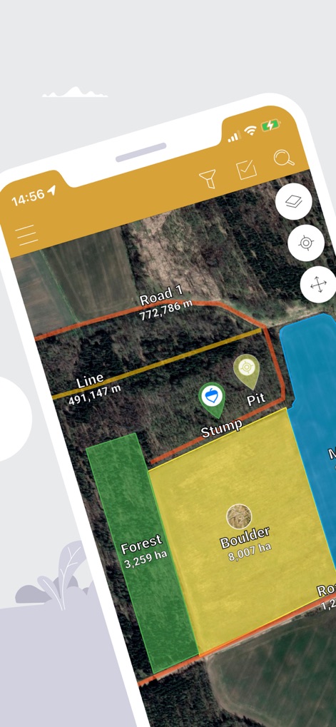
사용자는 다양한 색상으로 구분된 영역 표시와 정확한 거리 측정치를 통해 지형을 시각적으로 파악할 수 있습니다.
필드 매핑 솔루션
이 앱은 산업 전문가들이 신뢰하는 도구로, 드론 이미지와 함께 효율적인 현장 작업을 지원합니다.
신뢰할 수 있는 측정
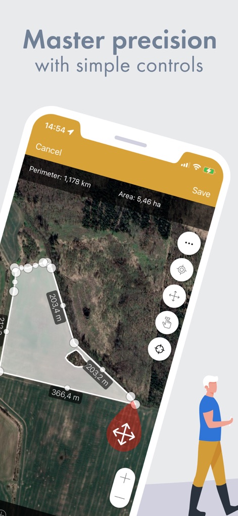
사용자는 정확한 둘레 및 면적 계산과 함께 직관적인 조작점을 활용하여 측정값을 세밀하게 조정할 수 있습니다.
정밀한 편집 도구
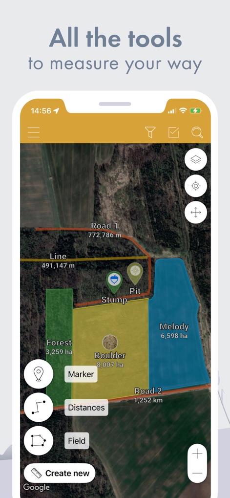
이 앱은 다양한 측정 옵션을 제공하며, 마커, 거리, 필드 생성을 통해 사용자가 원하는 방식으로 데이터를 수집할 수 있습니다.
모든 측정 도구
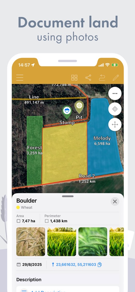
사용자는 특정 지형에 대한 영역 세부 정보와 함께 현장 사진 갤러리를 추가하여 포괄적인 기록을 남길 수 있습니다.
사진으로 기록하기
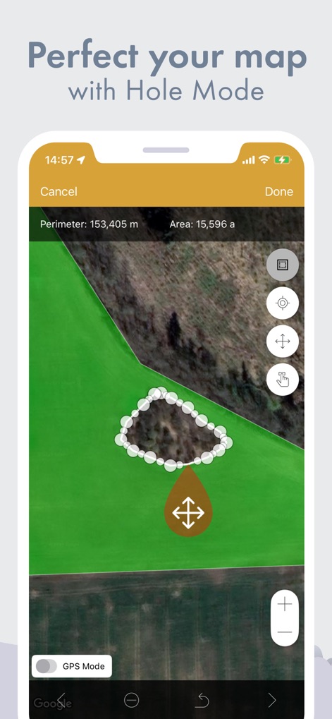
이 앱의 홀 모드를 활용하여 복잡한 지형 내의 제외 영역을 정확하게 측정하고 둘레 및 면적을 계산할 수 있습니다.
홀 모드로 정교하게
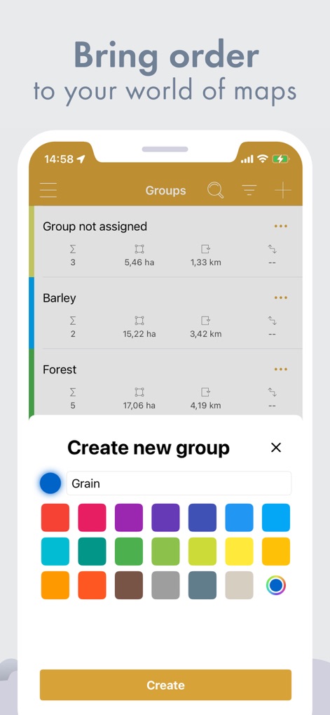
사용자는 측정 프로젝트를 그룹화하여 효율적으로 관리하고, 다양한 색상 옵션으로 새 그룹을 쉽게 생성할 수 있습니다.
맵 프로젝트 관리
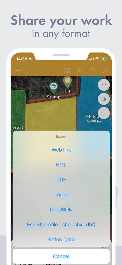
이 앱은 KML 및 Shapefile을 포함한 여러 전문적인 내보내기 형식을 지원하여 데이터를 쉽게 공유하고 활용할 수 있습니다.
다양한 형식으로 공유
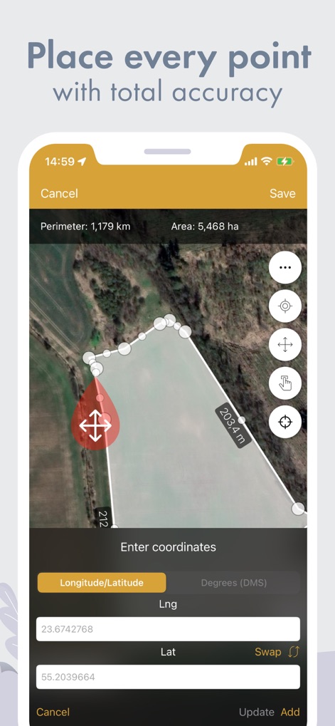
사용자는 경도 및 위도 좌표를 직접 입력하여 측정 지점을 정확하게 설정하고, 둘레와 면적을 정밀하게 계산할 수 있습니다.
정확한 지점 입력
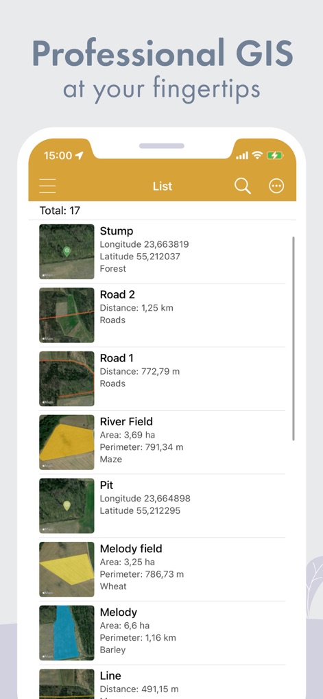
이 앱은 측정된 모든 항목의 목록을 제공하며, 각 항목에 대한 세부적인 지리 정보 시스템(GIS) 데이터를 확인할 수 있습니다.
전문적인 GIS 정보
설명
Download
비슷한 앱
유사한 기능과 사용자 경험을 가진 앱

Field MapS - Measure Land GPS
Aleksei Metelkin

Field Area MeasureーLand Parcel
Irina Metelkina

FieldCalc - GPS Area Measure
Pravin Gondaliya

Geo Field Area - GPS Measure
STOMBERG s.r.o

GLand: GPS Field Area Measure
Authai Yaprasat

Distance - Find My Distance
Mapnitude Company Limited

Area & Distance - Map Measure
Mapnitude Company Limited

Measure Map
Xuan Luong Do

Field Area Measure
Yaroslav Babenko
이 페이지는 앱이나 개발자의 공식 페이지가 아니며, 정보 제공 및 논평을 목적으로 작성된 독립 편집 간행물입니다. 명시적으로 달리 언급되지 않는 한, 해당 앱이나 개발자는 MWM, Apple, Google Play, 앱 퍼블리셔 또는 앱 개발자와 제휴, 보증, 후원, 승인 또는 공식적으로 연결되어 있지 않으며, 이 페이지의 어떤 내용도 해당 앱이 MWM의 서비스를 사용하여 개발되었음을 의미하지 않습니다. 모든 상표, 로고, 스크린샷 및 기타 콘텐츠는 해당 소유자의 자산입니다.