이 페이지는 앱이나 개발자의 공식 페이지가 아니며, 정보 제공 및 논평을 목적으로 작성된 독립 편집 간행물입니다. 명시적으로 달리 언급되지 않는 한, 해당 앱이나 개발자는 MWM, Apple, Google Play, 앱 퍼블리셔 또는 앱 개발자와 제휴, 보증, 후원, 승인 또는 공식적으로 연결되어 있지 않으며, 이 페이지의 어떤 내용도 해당 앱이 MWM의 서비스를 사용하여 개발되었음을 의미하지 않습니다. 모든 상표, 로고, 스크린샷 및 기타 콘텐츠는 해당 소유자의 자산입니다.
FlyQ+ EFB
4D 예측 날씨, 3D 합성 비전, 업계 최고의 GPS 스푸핑 보호 기능으로 상황 인식 능력을 극대화하세요. 더 큰 글꼴과 적은 탭으로 강력하면서도 직관적인 조종석 경험을 원하는 조종사를 위해 설계되었습니다.
조종석 환경을 위해 특별히 설계된 EFB로, 가독성이 높은 인터페이스와 작업량을 최소화하고 상황 인식 능력을 극대화하는 고급 안전 도구를 제공합니다.
고시인성 인터페이스
더 큰 글꼴과 간소화된 레이아웃으로 Silver Wings 사용자층을 위해 설계되어 난기류 비행 조건에서 화면 탭을 최소화합니다.
3D 합성 비전 및 AR
증강 현실과 3D 지형 디스플레이를 통해 구름 속이나 야간에 '엑스레이 비전'을 경험하고 주변 세상을 보는 방식을 변화시키세요.
다음 스크린샷과 설명은 앱의 공식 스토어 목록에서 직접 가져온 것이며 앱 개발자의 자산입니다.
앱 스토어
스크린샷
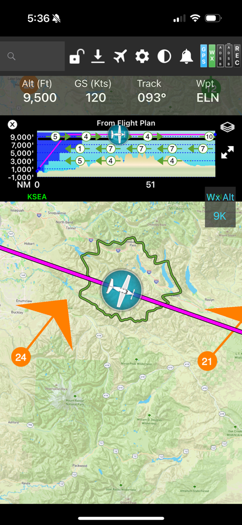
FlyQ plus EFB 비행 내비게이션 화면, 글라이드 링과 수직 프로필이 있는 이동 지도 표시
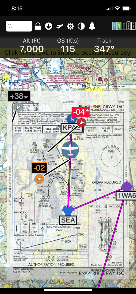
FlyQ+ EFB 앱 인터페이스, 비행 텔레메트리가 있는 디지털 섹셔널 지도 위에 RNAV 접근판이 오버레이된 상태 표시
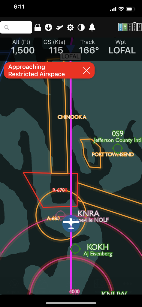
FlyQ plus 앱 인터페이스, 디지털 비행 지도에 제한 공역 경고 표시
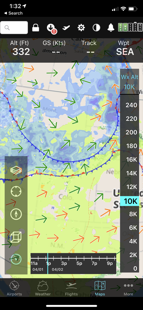
FlyQ+ EFB 모바일 인터페이스, 바람 벡터와 고도 슬라이더가 있는 예측 날씨 지도 표시
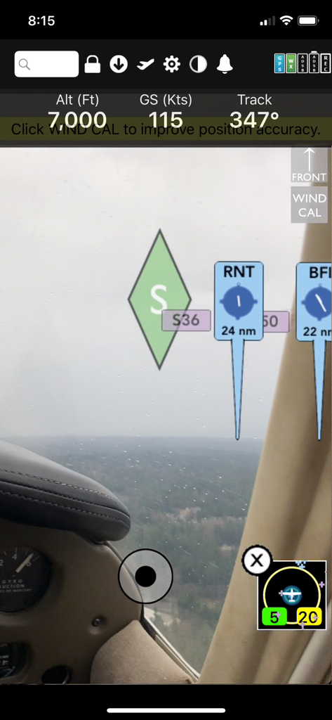
FlyQ Plus EFB 증강 현실 내비게이션 디스플레이, 실시간 조종석 보기 위에 고도, 지상 속도 및 공항 표시기 표시
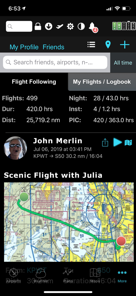
FlyQ plus EFB 앱, 조종사 비행 통계 및 풍경 비행 지도 표시
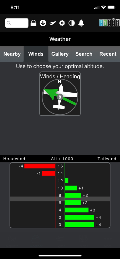
FlyQ Plus EFB 그래픽 바람 최적화기, 고도별 순풍 및 역풍 데이터 표시
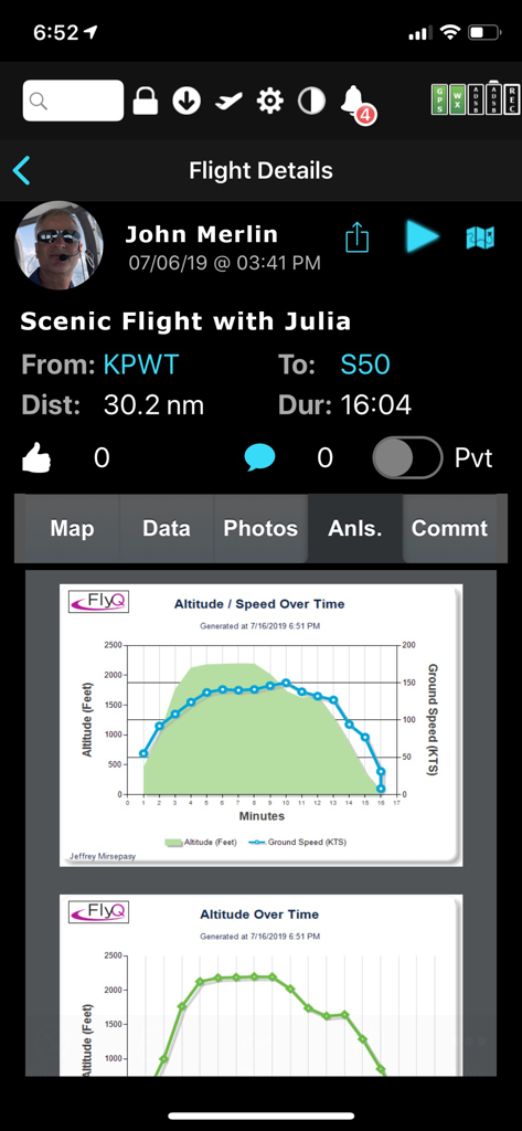
FlyQ EFB 비행 상세 화면, 고도 및 지상 속도에 대한 비행 후 분석 그래프 표시
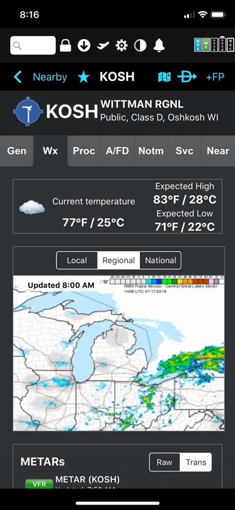
FlyQ plus EFB 앱에서 온도 및 지역 레이더가 표시되는 Wittman Regional Airport 날씨 디스플레이
설명
FlyQ+ EFB is a top-rated aviation app because it makes your flying easier and safer by thoughtfully integrating powerful features in a way that minimizes the number of screen taps and uses larger fonts to increase readability.
New features such as a glide ring, graphical weather briefing, ability to download two data cycles, and a navlog that expands/collapses airways/SIDs/STARs make flying safer and easier than ever before!
The Global Digital Map shows airports, airways, airspace, navaids, and waypoints from all around the world. Text rotates so it's always right-side up and the level of detail adapts to the zoom level.
Our exceptional "4D Predictive Weather" system uses a Timeline and Altitude Slider to help you analyze weather at different times - both past and future - and at different altitudes. 17 weather layers from both the Internet and ADS-B (e.g. Radar, Icing, Turbulence, PIREPs, Winds Aloft, Surface Winds, Surface Analysis, Satellite, and more), many tied to the Timeline and Altitude Slider, give you unprecedented pre-flight and in-flight safety.
Supports more than 20 ADS-B and in-panel devices: Stratus 3, Avidyne, Dynon, Stratux, and more.
The exclusive Augmented Reality (AR) feature provides situational awareness you'd previously only seen in sci-fi movies.
The Slingshot wireless system means FlyQ+ supplies maps, plates, and apt diagrams wirelessly to certified systems from BendixKing.
The Visual Logbook and Post Flight Playback / Analysis Graphs add a whole new dimension to your flying. Optionally connect with your friends to "see" and even replay their flights. CFI's can track student progress and remotely send endorsements.
Other key features include split screen, 3D synthetic vision, plates on the map, more than 4,600 airport diagrams, rich Documents support, extended runways, distance measurement, fuel prices, NOTAMS, wind-optimized flight planning, and plates for Mexico and Central America.
NEW! NaviGuard GPS anomaly detection guards against GPS spoofing and jamming
> Maps Your Way
+ Digital, 2D maps, 3D Syn Vis, Augmented Reality
+ Sectionals and IFR charts
+ TACs
+ Photo, road, terrain maps
+ 17 Weather Layers
+ Flight Track
+ Fuel Prices
+ TFRs
+ Obstacle and Terrain Avoidance
+ ADS-B Traffic and Weather
+ Extended runways with right-pattern indicators
+ Procedures on map
+ Rings / Extended Course Line
+ CAP grid
+ Heli and Gulf of Mexico charts
+ VFR Flyways
+ Syn Vis includes HITS boxes, EFIS display, TAWS, Obstacles, and AHRS support.
Night Mode preserves your night vision.
Split screen (iPad only) and single screen.
> Procedures
NEW! FlyQ+ includes the same FAA DO-200B certified Seattle Avionics geo-referenced approach plates and apt diagrams that we supply to certified avionics from Honeywell and Aspen.
Split screen can show a map and a procedure simultaneously.
> Flight Planning that Saves Time and Money
1. Automatically uses recently cleared ATC routes
2. Automatically plans fuel stops based on lowest cost
3. Uses expected winds to plot the fastest course
4. CAP/SAR patterns
5. Exchange flight plans with Dynon SkyView, Avidyne, and Aspen
6. Practice with X-Plane or MS Flight Sim / Prepar3D
> Weather
Amazing "4D Predictive Weather" uses a Timeline and Altitude slider to make detailed pre-flight and in-flight analysis easy. The Graphical Wind Optimizer uses red and green bars to show the headwind or tailwind at different altitudes. Also includes an extensive gallery of weather images.
> Airport Information
The Airport screen concisely shows key operational info, sat images, and rwy diagrams on a single screen. Weather, approach procedures, A/FD, and FBO info are just a tap away. Includes more than 4,600 SA Airport Diagrams.
> Data Manager
FlyQ+ makes it painless to download new data every month: spin and zoom a 3D globe to visually select the states you need.
> Try it before you buy it
Experience everything FlyQ+ EFB offers with a free 30-day subscription.
이 페이지는 앱이나 개발자의 공식 페이지가 아니며, 정보 제공 및 논평을 목적으로 작성된 독립 편집 간행물입니다. 명시적으로 달리 언급되지 않는 한, 해당 앱이나 개발자는 MWM, Apple, Google Play, 앱 퍼블리셔 또는 앱 개발자와 제휴, 보증, 후원, 승인 또는 공식적으로 연결되어 있지 않으며, 이 페이지의 어떤 내용도 해당 앱이 MWM의 서비스를 사용하여 개발되었음을 의미하지 않습니다. 모든 상표, 로고, 스크린샷 및 기타 콘텐츠는 해당 소유자의 자산입니다.