이 페이지는 앱이나 개발자의 공식 페이지가 아니며, 정보 제공 및 논평을 목적으로 작성된 독립 편집 간행물입니다. 명시적으로 달리 언급되지 않는 한, 해당 앱이나 개발자는 MWM, Apple, Google Play, 앱 퍼블리셔 또는 앱 개발자와 제휴, 보증, 후원, 승인 또는 공식적으로 연결되어 있지 않으며, 이 페이지의 어떤 내용도 해당 앱이 MWM의 서비스를 사용하여 개발되었음을 의미하지 않습니다. 모든 상표, 로고, 스크린샷 및 기타 콘텐츠는 해당 소유자의 자산입니다.

ForeFlight Mobile EFB
업계 표준을 신뢰하는 VFR 및 IFR 조종사들의 엘리트 커뮤니티에 참여하세요. 모든 것을 갖춘 임무 필수 조종석 도구에서 고급 날씨, 3D 합성 비전, 원활한 비행 기록으로 상황 인식 능력을 향상시키세요.
다운로드
1M+사용자 평점
총 평가 수
10K+개발사
카테고리
Weather지원 언어
3최신 버전
17.11.4크기
481.8 MB출시일
2009년 12월 16일올인원 전자 비행 가방
현대 조종사를 위해 설계된 강력하고 통합된 도구 모음으로 조종석 워크플로우를 간소화하고 안전을 강화하세요.
손쉬운 계획 및 기록
지능형 조언자를 통해 몇 초 만에 복잡한 경로를 계획하고 iPad 또는 iPhone에서 직접 FAA에 비행 계획을 제출하세요.
차세대 위험 인식
모든 조건에서 환경에 대한 명확한 그림을 제공하는 3D 합성 비전 및 지형 경고를 사용하여 완전한 자신감으로 비행하세요.
자주 묻는 질문
에 대해 알아야 할 모든 것 ForeFlight Mobile EFB
Does ForeFlight Mobile EFB offer a free trial?
네, ForeFlight Mobile EFB는 최고급 구독 요금제에 대한 30일 무료 체험을 제공합니다. 이용 가능한 요금제 및 추가 기능에 대한 자세한 내용은 웹사이트를 방문하시면 됩니다.
What flight planning features does ForeFlight offer?
ForeFlight는 지도에서 터치 플래닝, 양식 기반 항공편 보기, 경로/고도/절차 조언자, 그래픽 사전 비행 브리핑, 직접 항공편 계획 파일링을 제공합니다. 또한 비행 중에 참조할 수 있도록 전문적인 Navlogs를 생성합니다.
Can ForeFlight display real-time weather information for pilots?
네, ForeFlight는 애니메이션 레이더, 글로벌 위성, 상층풍, 글로벌 결빙, 난기류, 표면 분석을 포함한 대화형 날씨 레이어를 표시합니다. 또한 그래픽 AIR/SIGMET, 비행 범주, 가시성, 디코딩된 METAR, TAF 및 MOS 예보도 표시합니다.
Does ForeFlight Mobile EFB provide navigational charts and maps?
네, ForeFlight에는 데이터 기반 항공 지도, VFR 섹셔널, 고/저층 항로 차트, SID, STAR, 접근 및 택시 차트, 지형, 위성 및 거리 보기 등이 VFR 및 IFR 운항 모두를 위해 포함되어 있습니다.
Are geo-referenced approaches available in ForeFlight?
네, ForeFlight Mobile EFB는 지오레퍼런스 접근 및 택시 차트를 지원합니다. 이 차트는 실시간 GPS 위치를 표시하며 지도 보기에 날씨 및 위험 정보와 함께 오버레이되어 최고의 상황 인식 능력을 제공합니다.
How does ForeFlight Mobile EFB improve hazard awareness during flight?
ForeFlight는 글로벌 위험 인식 기술을 통해 위험 인식을 향상시킵니다. 위험 조언자 지도 레이어, 지형 프로필 보기 및 3D 합성 비전을 통합하여 전 세계의 지형 및 장애물 위험을 묘사합니다. 합성 비전은 AHRS 소스를 갖춘 백업 자세 표시기를 제공합니다.
Can pilots log their flights using the ForeFlight app?
네, ForeFlight Logbook을 사용하면 조종사가 쉽게 항공편을 기록하고 공유하고, 시간을 추적하고, 현재 상태를 검토하고, 인증서 및 등급을 기록하고, 전자 교관 추천을 받을 수 있습니다. 데이터는 모든 장치에서 자동으로 동기화됩니다.
What type of documents are available in ForeFlight Mobile EFB?
ForeFlight는 FAR/AIM 및 차트 보충 자료를 포함한 내장 문서 카탈로그를 제공합니다. 이를 통해 앱 내에서 고급 문서 관리가 가능하여 조종사가 필수 참조 자료를 쉽게 사용할 수 있습니다.
Does ForeFlight include airport and FBO information?
네, ForeFlight는 수천 개의 위치에 대한 종합적인 공항, FBO 및 연료 가격 정보를 제공합니다. 여기에는 깔끔하게 정리된 공항 세부 정보, METAR, TAF 및 MOS 예보가 포함됩니다.
Is there a 3D flight preview feature in ForeFlight?
네, ForeFlight Mobile EFB는 몰입형 3D 비행 미리보기 기능을 제공합니다. 이 기능을 통해 사용자는 출발 전에 3차원 환경에서 계획된 비행 경로를 시각화할 수 있습니다.
Does ForeFlight display live aircraft traffic?
네, ForeFlight Mobile EFB는 실시간 글로벌 항공 교통을 스트리밍할 수 있습니다. 이 기능은 주변 항공기를 표시하여 조종사에게 향상된 상황 인식을 제공합니다.
What is the "Next-Gen Airport Familiarization" feature in ForeFlight?
ForeFlight는 고급 시각 도구를 통해 "차세대 공항 숙지" 기능을 제공합니다. 스크린샷 #7은 이 기능을 시연하며, 조종사가 공항 레이아웃을 이해하고 착륙을 준비하는 데 도움이 되는 상세한 3D 시점을 제공합니다.
다음 스크린샷과 설명은 앱의 공식 스토어 목록에서 직접 가져온 것이며 앱 개발자의 자산입니다.
앱 스토어
스크린샷
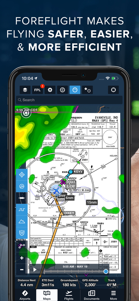
ForeFlight 모바일 EFB 앱에 내비게이션 지도, 날씨 레이더 및 비행 계기 데이터가 표시됩니다.
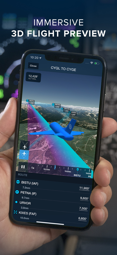
산악 지형 위로 ForeFlight 모바일 EFB 몰입형 3D 비행 미리 보기 기능이 표시된 스마트폰을 들고 있는 조종사
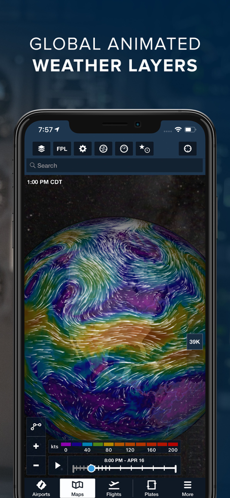
ForeFlight 모바일 EFB 인터페이스에 3D 지구본에 표시되는 글로벌 애니메이션 날씨 레이어와 바람 흐름이 표시됩니다.
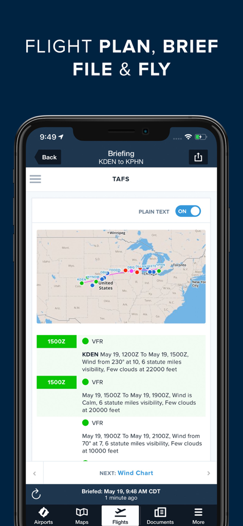
ForeFlight 비행 브리핑 인터페이스에 지도 경로 및 TAF 날씨 세부 정보가 표시됩니다.
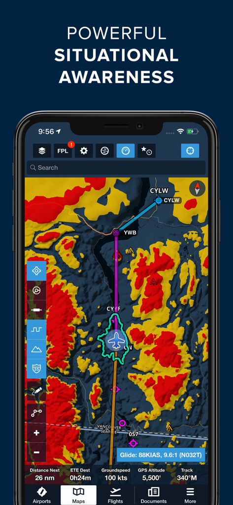
위험 지형 및 비행 경로 데이터를 보여주는 상황 인식 내비게이션 지도가 표시된 ForeFlight 모바일 EFB 앱을 보여주는 스마트폰 화면
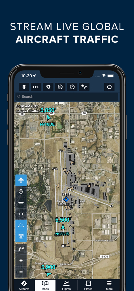
ForeFlight 앱에 공항 위성 지도에 실시간 글로벌 항공기 교통량이 표시됩니다.
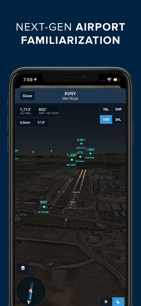
KVNY 반 나이스의 야간 공항 숙지 3D 뷰를 보여주는 ForeFlight 모바일 EFB
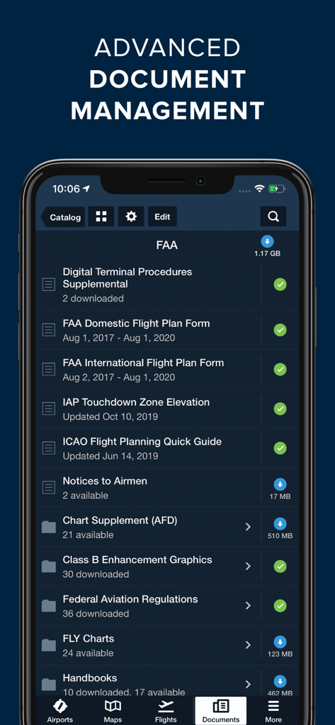
ForeFlight 모바일 EFB 앱 화면에 FAA 절차 및 비행 계획 문서의 디지털 라이브러리가 표시됩니다.
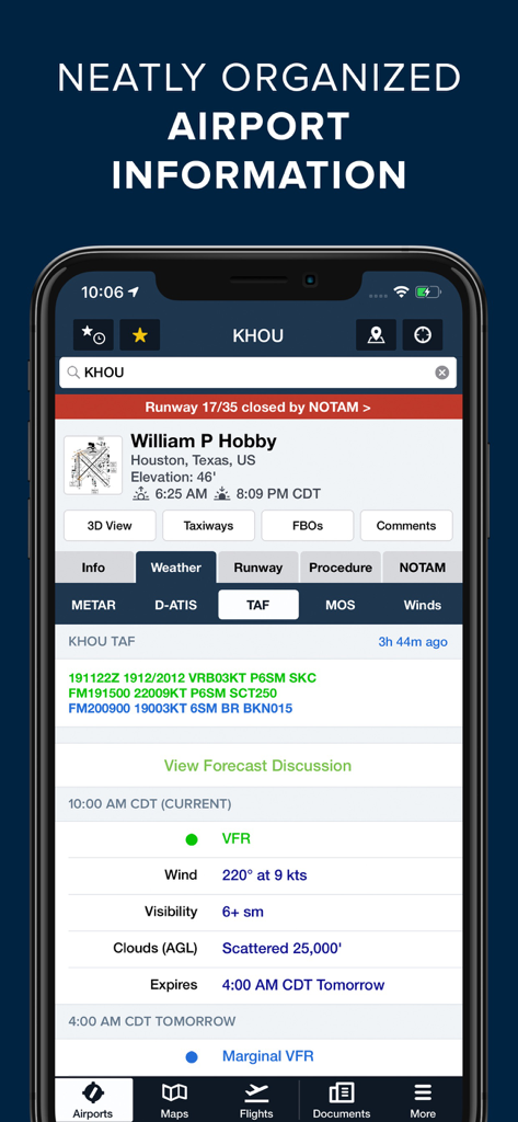
조종사를 위해 깔끔하게 정리된 공항 정보 및 날씨 데이터가 표시되는 ForeFlight 모바일 EFB
설명
Download
비슷한 앱
유사한 기능과 사용자 경험을 가진 앱

Navigraph Charts
Navigraph KB

SkyDemon
Divelements Limited

Airports
Applicate Ltd

OzRunways EFB
OzRunways Pty. Ltd.

fDeck: flight instruments
Darren Yeates

Noisy Goose
Automata Solutions Ltd.

StationWeather - METAR and TAF
Oliver Puetz

Drone UAV Fly Forecast: AirMap
MONIQ TAP COMPANY LIMITED

Airmate
Myriel Aviation SA
이 페이지는 앱이나 개발자의 공식 페이지가 아니며, 정보 제공 및 논평을 목적으로 작성된 독립 편집 간행물입니다. 명시적으로 달리 언급되지 않는 한, 해당 앱이나 개발자는 MWM, Apple, Google Play, 앱 퍼블리셔 또는 앱 개발자와 제휴, 보증, 후원, 승인 또는 공식적으로 연결되어 있지 않으며, 이 페이지의 어떤 내용도 해당 앱이 MWM의 서비스를 사용하여 개발되었음을 의미하지 않습니다. 모든 상표, 로고, 스크린샷 및 기타 콘텐츠는 해당 소유자의 자산입니다.