이 페이지는 앱이나 개발자의 공식 페이지가 아니며, 정보 제공 및 논평을 목적으로 작성된 독립 편집 간행물입니다. 명시적으로 달리 언급되지 않는 한, 해당 앱이나 개발자는 MWM, Apple, Google Play, 앱 퍼블리셔 또는 앱 개발자와 제휴, 보증, 후원, 승인 또는 공식적으로 연결되어 있지 않으며, 이 페이지의 어떤 내용도 해당 앱이 MWM의 서비스를 사용하여 개발되었음을 의미하지 않습니다. 모든 상표, 로고, 스크린샷 및 기타 콘텐츠는 해당 소유자의 자산입니다.
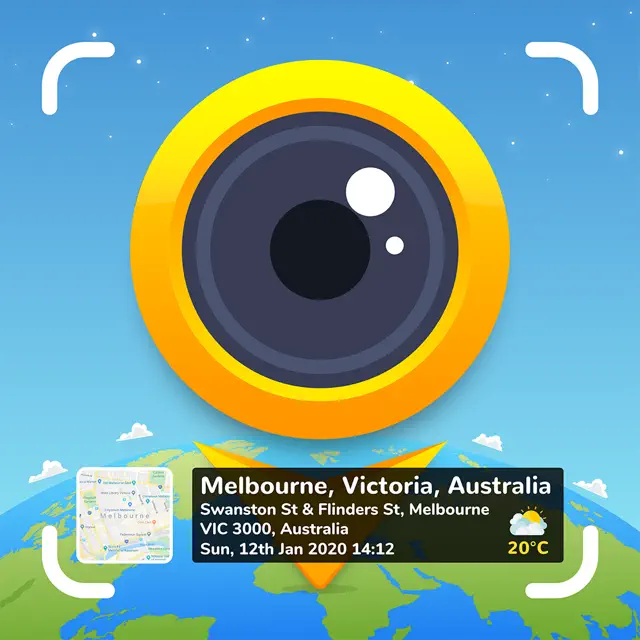
GPS Map Camera : Geo Photos
당신의 사진이 단순한 이미지가 아니라, 정밀한 현장 보고서로 탈바꿈합니다. 이 앱은 당신의 시각적 기록에 시간과 공간의 DNA를 각인시킵니다.
다운로드
7.5M+사용자 평점
총 평가 수
300.8K개발사
카테고리
Photo & Video지원 언어
11최신 버전
1.8.1크기
96.6 MB출시일
2020년 3월 30일정확한 위치 기반 데이터와 풍부한 메타데이터로 사진을 강화하는 핵심 기능 검토
'GPS 지도 카메라: 지오 포토스' 앱 주요 기능 분석
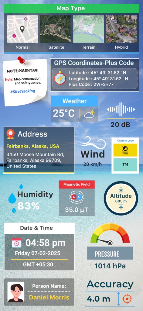
정확한 위치 및 지도 정보 스탬프
이 앱은 사진에 GPS 좌표(위도, 경도), 주소, 지도 유형(일반, 위성, 지형, 하이브리드) 등의 상세한 지리 정보를 자동으로 스탬프하여 정확한 위치 기록을 보장합니다.
환경 데이터 자동 기록 및 스탬프
이 도구는 날씨(온도, 바람, 습도), 자기장, 고도, 압력, 나침반 방향과 같은 환경 데이터를 자동으로 측정하고 사진에 스탬프하여 풍부한 상황별 정보를 제공합니다.
사용자 정의 가능한 날짜 및 시간 스탬프
사용자는 다양한 형식으로 날짜와 시간을 사진에 스탬프할 수 있어 이벤트 기록, 작업 진행 상황 추적 등 모든 종류의 문서화에 필수적인 정확한 시간 정보를 제공합니다.
고급 템플릿 및 맞춤형 메타데이터
이 앱은 고급 템플릿을 통해 브랜드 로고, 관련 메모, 해시태그를 추가하고, GPS 좌표를 DMS 또는 십진수 형식으로 설정하는 등 사진에 포함될 메타데이터를 광범위하게 맞춤 설정할 수 있게 해줍니다.
실시간 위치 추적 및 공유
이 앱은 캡처된 사진과 함께 실시간 위치를 추적하고 가족 및 친구와 공유하여 여정이나 특정 장소의 경험을 쉽게 전달할 수 있게 해줍니다.
통합 카메라 제어 기능
이 앱은 격자, 비율, 전면/후면 카메라 전환, 플래시, 초점, 거울 모드, 타이머, 촬영 사운드 지원 등 맞춤형 GPS 카메라 기능을 제공하여 앱 내에서 최적화된 사진 촬영 경험을 제공합니다.
자주 묻는 질문
에 대해 알아야 할 모든 것 GPS Map Camera : Geo Photos
How do I add GPS location stamps to my photos using GPS Map Camera?
To add GPS location stamps, install GPS Map Camera, select Advance or Classic Templates, arrange stamp formats, and adjust settings. The app automatically adds GPS location stamps to your clicked pictures.
What types of map data can the GPS Map Camera app display on photos?
The GPS Map Camera app can display map data as Normal, Satellite, Terrain, and Hybrid options. Users can select these custom map types within the Advance Template section.
Can I customize the date and time format on my GPS Map Camera photo stamps?
Yes, GPS Map Camera allows users to add Date & Timestamp from various formats as an image tag. This customization is available within the Advance Template section settings.
Does GPS Map Camera support adding custom logos to photo stamps?
Yes, GPS Map Camera supports adding custom brand logos to photo stamps. This feature is available in the Advance Template settings for personalized branding.
What environmental details can GPS Map Camera stamp onto photos?
GPS Map Camera stamps environmental details including Weather (Fahrenheit/Celsius), Wind speed, Humidity, Pressure, Altitude, and Magnetic Field directly onto photos.
Can GPS Map Camera geotag photos with both Latitude and Longitude?
Yes, GPS Map Camera geotags photos with both Latitude and Longitude. Users can set GPS Coordinates from DMS or Decimal Options for the GPS Stamp in the Advance Template.
Is the GPS Map Camera app useful for real estate professionals?
Yes, the GPS Map Camera app is useful for real estate professionals. They can easily apply GPS Map Location stamps to their site photos for clear documentation and client communication.
Can users add notes or hashtags to photos with GPS Map Camera?
Yes, users can add relatable notes and hashtags to their photos using the GPS Map Camera app. This customization option is available within the Advance Template settings.
Does the GPS Map Camera app track live location with captured photos?
Yes, the GPS Map Camera app tracks the live location along with captured photos. This feature helps users geotag their memories and movements accurately.
What custom camera features does GPS Map Camera offer?
GPS Map Camera offers a custom camera with Grid, Ratio, Front & Selfie camera support, Flash, Focus, Mirror, Timer, and capture sound support.
다음 스크린샷과 설명은 앱의 공식 스토어 목록에서 직접 가져온 것이며 앱 개발자의 자산입니다.
앱 스토어
스크린샷
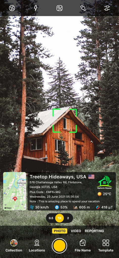
이 앱은 사용자가 촬영한 숲속 오두막 사진에 정확한 지도 위치와 실시간 온도 정보를 추가하여 풍부한 문맥을 제공합니다.
지리정보 사진 스탬프
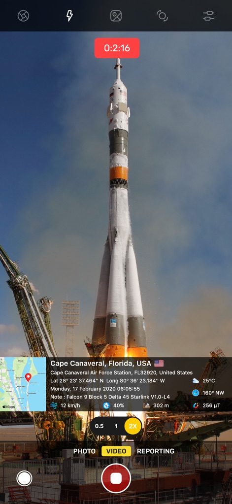
사용자는 로켓 발사 현장을 비디오로 기록하면서 케이프 커내버럴의 정확한 지리 정보와 현재 기온 같은 환경 데이터를 자동으로 삽입할 수 있습니다.
생생한 비디오 기록
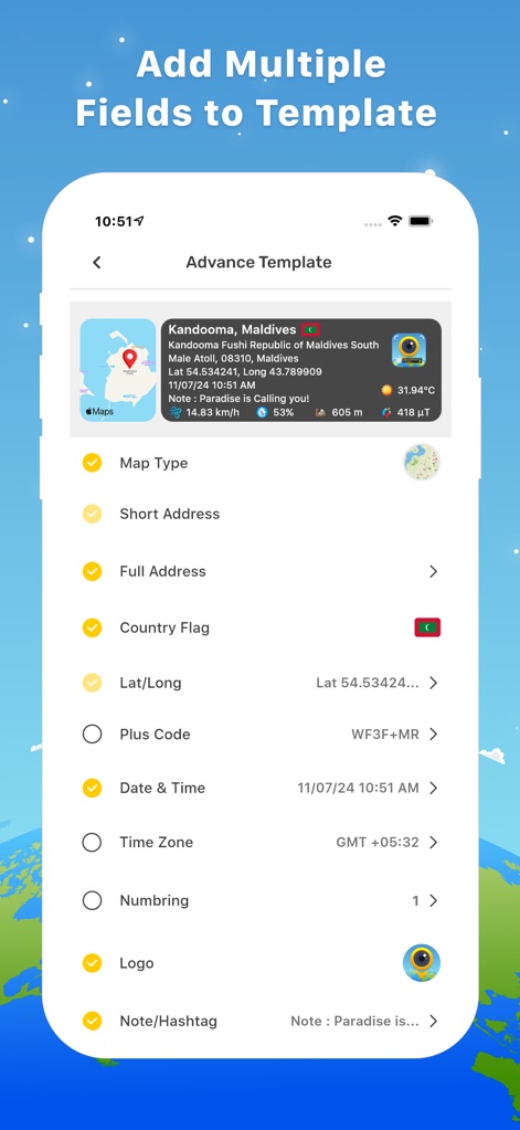
이 앱은 사용자가 지도 유형, 주소, 경위도, 날짜 및 시간과 같은 다양한 필드를 템플릿에 추가하여 사진 스탬프를 자유롭게 구성하도록 지원합니다.
템플릿 맞춤 설정
이 도구는 사용자가 원하는 대로 지도 유형, GPS 좌표, 날씨, 주소, 풍속, 고도 등 방대한 위치 및 환경 데이터를 시각적으로 탐색하고 확인할 수 있게 합니다.
상세 데이터 분석
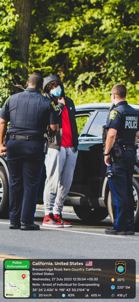
이 앱은 사용자가 법 집행 현장을 기록할 때 정확한 지도 정보와 함께 '과속 위반 체포'와 같은 상세 메모를 사진에 직접 추가할 수 있도록 돕습니다.
현장 기록 및 증거
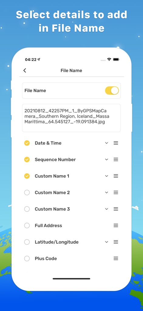
사용자는 파일명에 날짜 및 시간, 순서 번호, 전체 주소 등 다양한 세부 정보를 포함하도록 선택하여 사진 관리를 효율적으로 수행할 수 있습니다.
파일명 사용자화
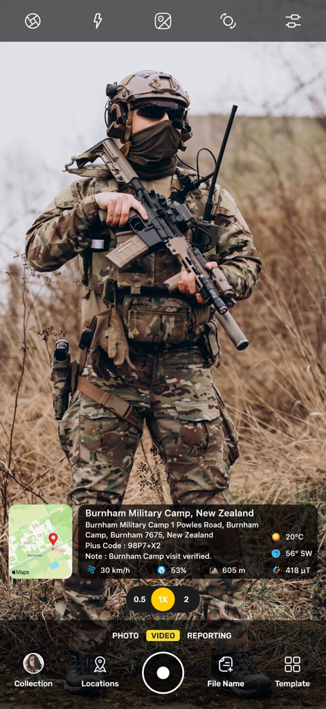
이 도구는 군사 훈련 또는 현장 임무 시 번햄 군사 캠프의 정확한 위치와 '방문 확인'과 같은 특정 메모를 사진에 통합하여 문서화합니다.
현장 임무 기록
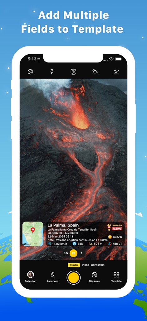
사용자는 화산 폭발과 같은 중요한 사건을 촬영하면서 라 팔마의 정확한 지리적 위치와 실시간 기상 조건을 사진에 기록하여 상황을 명확히 전달할 수 있습니다.
재난 현장 기록
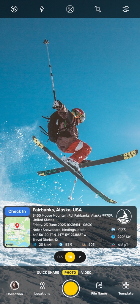
이 앱은 스키어의 역동적인 순간을 포착하며 페어뱅크스의 정확한 위치와 함께 영하의 온도와 같은 환경 데이터를 사진에 추가하여 생생함을 더합니다.
역동적인 순간 포착
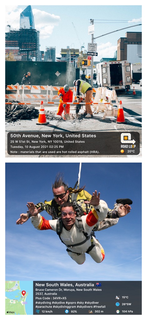
이 도구는 뉴욕의 건설 현장과 호주 상공의 스카이다이빙 사진에 각 장소의 주소와 풍속, 기압 같은 상세한 환경 정보를 정확히 기록하여 활용성을 높입니다.
다양한 활동 기록
설명
Download
비슷한 앱
유사한 기능과 사용자 경험을 가진 앱

Timestamp Camera -AI Timestamp
Shanghai Zongchong Information Technology Co., Ltd

Timestamp Camera - Date Stamp
Artify Inc.

Timestamp Camera: Time & GPS
Practical Apps from Sweden AB

Timestamp camera - gps cam
Guangzhou Siyue Network Technology Co., Ltd.

DateStamper
Jordan Hipwell

Timestamp Camera Basic
玉彬 陈

Timestamp Camera: Time stamp
燕倩 费

Timestamp Camera - Time & GPS
Shaanxi Ruidebao Technology Co.,Ltd

Timestamp Camera - Aio GPS Cam
周萍 黄
이 페이지는 앱이나 개발자의 공식 페이지가 아니며, 정보 제공 및 논평을 목적으로 작성된 독립 편집 간행물입니다. 명시적으로 달리 언급되지 않는 한, 해당 앱이나 개발자는 MWM, Apple, Google Play, 앱 퍼블리셔 또는 앱 개발자와 제휴, 보증, 후원, 승인 또는 공식적으로 연결되어 있지 않으며, 이 페이지의 어떤 내용도 해당 앱이 MWM의 서비스를 사용하여 개발되었음을 의미하지 않습니다. 모든 상표, 로고, 스크린샷 및 기타 콘텐츠는 해당 소유자의 자산입니다.