이 페이지는 앱이나 개발자의 공식 페이지가 아니며, 정보 제공 및 논평을 목적으로 작성된 독립 편집 간행물입니다. 명시적으로 달리 언급되지 않는 한, 해당 앱이나 개발자는 MWM, Apple, Google Play, 앱 퍼블리셔 또는 앱 개발자와 제휴, 보증, 후원, 승인 또는 공식적으로 연결되어 있지 않으며, 이 페이지의 어떤 내용도 해당 앱이 MWM의 서비스를 사용하여 개발되었음을 의미하지 않습니다. 모든 상표, 로고, 스크린샷 및 기타 콘텐츠는 해당 소유자의 자산입니다.

Land id®
부동산 전문가와 투자자가 한 번의 탭으로 1억 5,500만 개의 필지, 지형 및 소유권 세부 정보에 액세스할 수 있는 업계 최고의 도구입니다. 현장에서 오프라인으로도 사용 가능합니다.
다운로드
510K+사용자 평점
총 평가 수
3K+개발사
카테고리
Productivity지원 언어
1최신 버전
5.29.0크기
270.0 MB출시일
2016년 11월 9일토지 전문가를 위한 정밀 매핑
소유권 데이터, 3D 지형 및 현장용으로 설계된 전문가 수준의 매핑 도구에 즉시 액세스하여 실사 속도를 높이세요.
포괄적인 필지 인텔리전스
1억 5,500만 개 이상의 필지에 대한 소유자 세부 정보, 세금 가치 및 판매 이력에 즉시 액세스하여 기회를 포착하고 리스크를 완화하세요.
고급 3D 및 지형 분석
등고선과 몰입형 3D 뷰로 지형을 시각화하여 어디서나 토양 유형, 건축 가능 부지 및 범람원을 평가하세요.
자주 묻는 질문
에 대해 알아야 할 모든 것 Land id®
Land id에서 무료 체험 기간을 제공하나요?
네, Land id는 무료 7일 체험 기간을 제공합니다. 이 체험 기간 동안 모든 Land id 플랜에 대한 전체 액세스가 가능합니다.
Land id 앱은 어떤 핵심 기능을 제공하나요?
Land id는 광범위한 부동산 데이터 카드, 3D 부동산 시각화, 부동산의 쉬운 식별 및 매핑을 제공합니다. 등고선, 광섬유 밀도, 지하수 세부 정보와 같은 기능이 포함되어 있습니다.
Land id에서 부동산 경계 및 토지 소유 정보를 표시할 수 있나요?
네, Land id는 부동산 경계선, 필지 경계, 토지 소유 정보를 즉시 표시합니다. 전국 1억 5,500만 건 이상의 필지 기록에 액세스할 수 있습니다.
Land id 구독은 월별로 얼마인가요?
표준 Land id 플랜의 월별 비용은 월별 청구 시 $15, 연간 청구 시 월 $7($84/년)입니다.
Land id는 3D 부동산 보기 및 등고선을 지원하나요?
네, Land id를 사용하면 모든 부동산을 2D 또는 3D로 볼 수 있어 위치를 생생하게 보여줍니다. 또한 지도에서 등고선을 사용하여 지형의 고도를 보여줍니다.
Land id에서 현장 작업을 위한 오프라인 액세스를 제공하나요?
Land id는 현장 사용 및 위성 GPS 추적을 위한 오프라인 액세스를 제공합니다. 이를 통해 사용자는 인터넷 연결 없이 부동산 데이터에 액세스할 수 있습니다.
Land id에서 수역 및 홍수 위험 데이터를 표시할 수 있나요?
네, Land id는 습지, 지하수 우물, FEMA 홍수터 정보를 포함한 수자원 액세스 세부 정보를 식별합니다. 이는 홍수 위험을 평가하고 토지 이용 결정을 내리는 데 도움이 됩니다.
Land id 프리미엄에는 어떤 추가 기능이 포함되어 있나요?
Land id 프리미엄에는 웹 링크를 통해 3개의 맞춤 지도를 만들고 공유하는 기능, 지도 제작 도구, 고해상도 항공 지도 액세스가 포함됩니다. 또한 모바일 오프라인 지도 제작도 가능합니다.
Land id Pro의 기능은 무엇인가요?
Land id Pro를 사용하면 사용자가 웹사이트에 지도를 임베드하고, 회사 정보로 지도를 브랜딩하고, 측량, 플랫, 이미지 오버레이 도구를 사용할 수 있습니다. 또한 등기부 표시 및 고해상도 인쇄 지도도 제공합니다.
Land id Pro Unlimited에서 CSV 보고서를 생성할 수 있나요?
네, Land id Pro Unlimited는 CSV 보고서 및 우편 명단을 생성할 수 있습니다. 이 기능은 레코드당 7센트의 요금이 부과됩니다.
다음 스크린샷과 설명은 앱의 공식 스토어 목록에서 직접 가져온 것이며 앱 개발자의 자산입니다.
앱 스토어
스크린샷
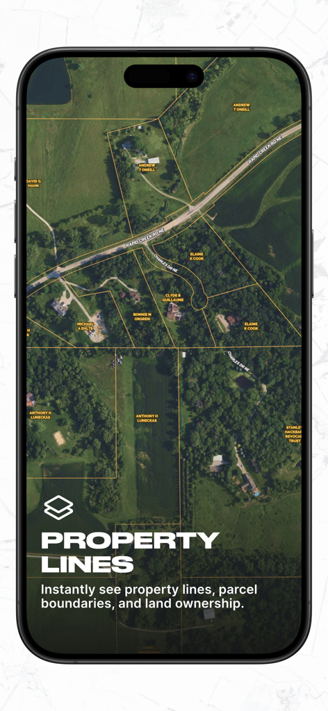
부동산 경계선과 토지 소유자 이름이 표시된 위성 이미지를 보여주는 Land id 앱 스크린샷
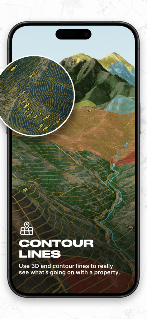
전문적인 토지 분석을 위한 상세한 등고선과 고도 표시가 포함된 3D 지형도를 보여주는 Land id 모바일 앱 인터페이스.
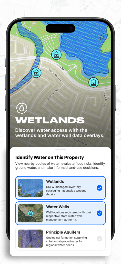
부동산 지도 위에 습지 및 관정 데이터 오버레이를 보여주는 Land id 앱 인터페이스
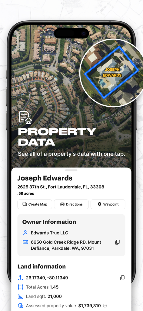
소유자 정보 및 필지 면적이 표시된 상세 부동산 데이터 카드가 있는 Land id 앱의 스마트폰 화면
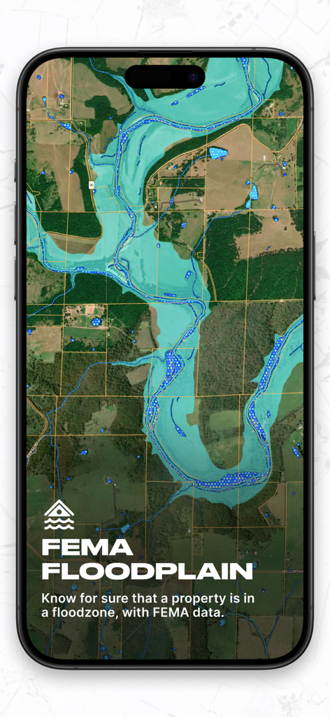
실사를 위해 위성 부동산 지도 위에 FEMA 범람원 데이터 오버레이를 보여주는 Land id 앱 인터페이스.
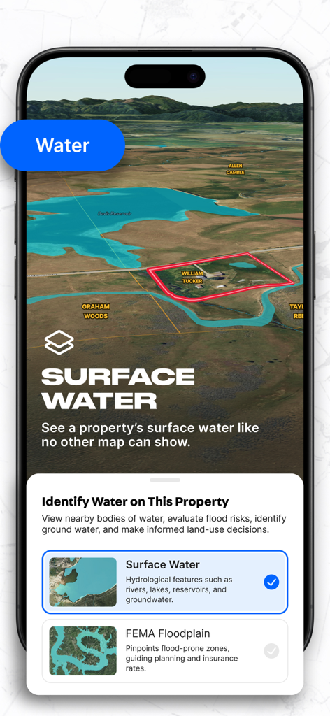
3D 부동산 필지 지도에서 지표수 및 FEMA 범람원 매핑을 보여주는 Land id 앱 인터페이스.
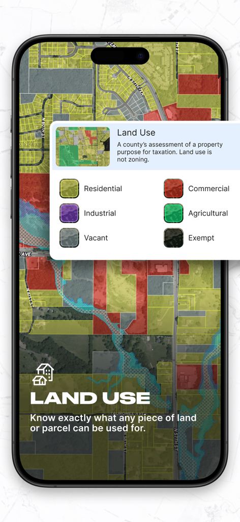
주거용, 상업용, 산업용 등 토지 용도별로 분류된 부동산 필지의 색상 코드 지도를 보여주는 Land id 앱의 모바일 화면.
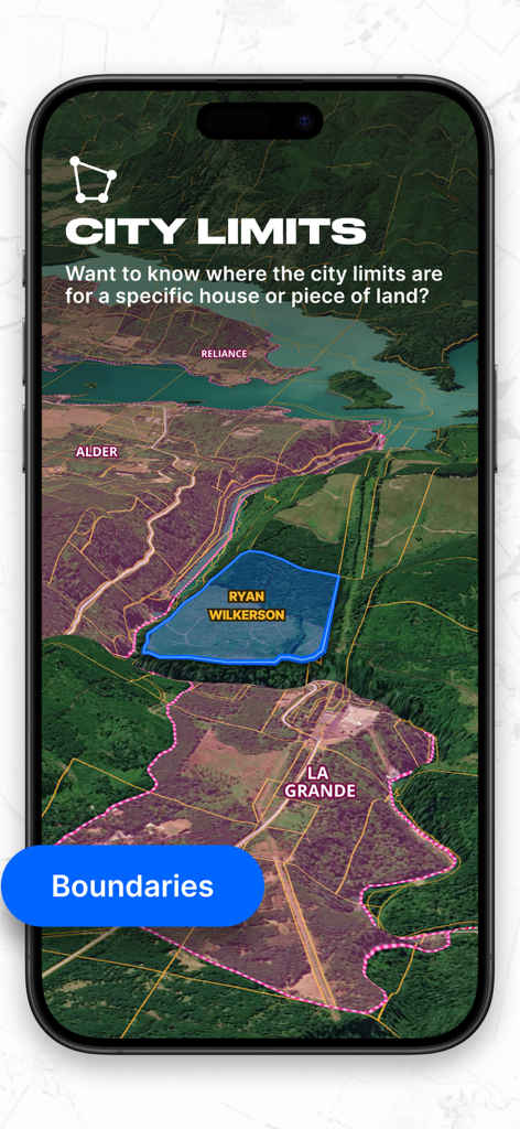
3D 지형도에 시 경계와 부동산 경계를 표시하는 Land id 앱
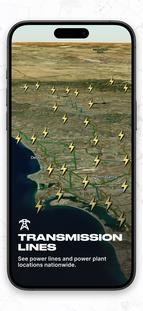
3D 지형도에서 전국 송전선 및 발전소 위치를 보여주는 Land id 앱 인터페이스.
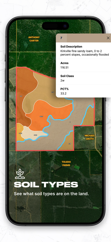
토양 설명 및 면적이 포함된 부동산 데이터 카드와 색상별 토양 유형 지도를 보여주는 Land id 앱의 모바일 인터페이스
설명
Download
비슷한 앱
유사한 기능과 사용자 경험을 가진 앱

LandGlide: Find Property Lines
Real Estate Portal USA, LLC

Regrid Property App
Loveland Technologies, LLC

DealCheck: Analyze Real Estate
Fortnoff Financial LLC

Reventure App
Reventure App LLC

Acres: Land Data & Parcel Maps
AcreMaps, LLC

Tapusor
TUVIMER ARGE FAALIYETLERI VE TEKNOLOJI SISTEMLERITICARET ANONIM SIRKETI

Endeksa: Value & Sell Property
Endeksa Teknoloji Anonim Sirketi

Detector Maps
GOLD DISCOVERY SOLUTIONS PTY LTD

Parceled Land Map
Uri Nemirovsky
이 페이지는 앱이나 개발자의 공식 페이지가 아니며, 정보 제공 및 논평을 목적으로 작성된 독립 편집 간행물입니다. 명시적으로 달리 언급되지 않는 한, 해당 앱이나 개발자는 MWM, Apple, Google Play, 앱 퍼블리셔 또는 앱 개발자와 제휴, 보증, 후원, 승인 또는 공식적으로 연결되어 있지 않으며, 이 페이지의 어떤 내용도 해당 앱이 MWM의 서비스를 사용하여 개발되었음을 의미하지 않습니다. 모든 상표, 로고, 스크린샷 및 기타 콘텐츠는 해당 소유자의 자산입니다.