이 페이지는 앱이나 개발자의 공식 페이지가 아니며, 정보 제공 및 논평을 목적으로 작성된 독립 편집 간행물입니다. 명시적으로 달리 언급되지 않는 한, 해당 앱이나 개발자는 MWM, Apple, Google Play, 앱 퍼블리셔 또는 앱 개발자와 제휴, 보증, 후원, 승인 또는 공식적으로 연결되어 있지 않으며, 이 페이지의 어떤 내용도 해당 앱이 MWM의 서비스를 사용하여 개발되었음을 의미하지 않습니다. 모든 상표, 로고, 스크린샷 및 기타 콘텐츠는 해당 소유자의 자산입니다.

Organic Maps・Maps & Navigation
데이터 연결 없이도 세상이 당신의 손 안에. 이것이 바로 지도 앱이 제공해야 할 진짜 자유다.
다운로드
1M+사용자 평점
총 평가 수
15.2K개발사
카테고리
Navigation지원 언어
48최신 버전
2026.04.07크기
139.6 MB출시일
2021년 6월 12일주요 특징 및 기능
Organic Maps・Maps & Navigation 앱 분석
개인 정보 보호 중심 설계
이 앱은 사용자 데이터를 수집하거나 식별자를 사용하지 않아 데이터 유출 위험이 없으며, 광고나 방해 요소 없이 깨끗하고 사적인 지도 경험을 제공합니다.
100% 완전 오프라인 기능
이 도구는 검색 및 내비게이션을 포함하여 100% 오프라인에서 작동하여 인터넷 연결 없이 지도를 탐색하고 길을 찾을 수 있습니다. 모바일 데이터 및 로밍 요금을 절약하고 배터리 수명을 크게 연장시킬 수 있습니다.
상세하고 최신 지도 데이터
이 앱의 지도는 세부 정보가 풍부하며 2주마다 업데이트되어 실제 상황을 반영합니다. 건물 라벨, 벤치, 하이킹 경로 등 유용한 정보를 포함하여 사용자에게 정확하고 신뢰할 수 있는 길 안내를 제공합니다.
정확한 GPS 내비게이션
이 도구는 음성 안내와 턴바이턴 방향을 제공하며 도보, 하이킹, 자전거, 운전 경로 등 다양한 이동 수단에 대한 최적의 경로를 계산합니다. 여러 경유지를 포함한 경로 설정도 지원하여 사용자의 이동을 돕습니다.
OpenStreetMap 기반 커뮤니티 협력
이 앱은 OpenStreetMap을 기반으로 하여 전 세계 수백만 자원봉사자가 구축하고 유지 관리하는 상세한 지도를 사용합니다. 이를 통해 사용자는 신뢰할 수 있는 최신 정보에 접근하고, 지도를 개선하는 데 기여할 수 있습니다.
다양한 활동을 위한 지도 스타일
이 도구는 아웃도어, 등고선, 하이킹, 사이클링, 지하철 등 사용자의 활동에 맞는 다양한 지도 레이어를 선택할 수 있게 하여 특정 요구에 최적화된 시각 정보를 제공합니다.
트랙 기록 및 공유
이 앱은 사용자가 자신의 경로와 즐겨찾는 장소를 기록, 가져오기, 내보내기 및 공유할 수 있도록 지원합니다. KML, KMZ, GPX, GeoJSON 형식과 호환되어 다양한 활용이 가능합니다.
빠른 성능
이 도구는 확대/축소, 검색 및 경로 계산이 매우 빠르게 작동하여 사용자에게 지연 없는 원활한 지도 경험을 제공합니다.
자주 묻는 질문
에 대해 알아야 할 모든 것 Organic Maps・Maps & Navigation
Does Organic Maps work offline?
Yes, Organic Maps functions 100% offline, including search and navigation. Users can explore maps and get directions without an internet connection, saving mobile data and battery life.
Is Organic Maps free to use?
Yes, Organic Maps is 100% free. It is also ad-free and does not require in-app purchases for full functionality, providing a completely free mapping experience without hidden costs.
Does Organic Maps collect user data?
No, Organic Maps is privacy-first and does not collect any user data or identifiers. This ensures no data leaks, ads, or noisy notifications, providing a clean private map experience.
What types of navigation does Organic Maps offer?
Organic Maps provides voice-guided, turn-by-turn navigation for walking, hiking, cycling, and driving routes. It supports routes between cities, countries, multiple waypoints, and CarPlay.
How often are maps updated in Organic Maps?
Maps in Organic Maps are updated biweekly. The app uses OpenStreetMap data, which is refreshed every two weeks, ensuring the maps reflect current real-world conditions and details accurately.
What data source does Organic Maps use for its maps?
Organic Maps uses OpenStreetMap, a wiki-style world map built and maintained by millions of volunteers. This community effort results in highly detailed and often more accurate maps.
Can users record and import custom routes in Organic Maps?
Yes, Organic Maps includes a Track Recorder feature. Users can record, import, export, and share their routes and favorite places, supporting KML, KMZ, GPX, and GeoJSON formats.
How can I find points of interest (POIs) with Organic Maps?
Organic Maps allows users to search by address, name, or category to discover millions of Points of Interest (POIs). It provides detailed information like opening hours and Wikipedia articles, all offline.
Does Organic Maps offer different map styles or layers?
Yes, Organic Maps offers various map styles tailored to activities, including Outdoors, Contour Lines, Hiking, Cycling, and Metro/Subway. Users can switch layers to view specific routes.
Does Organic Maps display advertisements?
No, Organic Maps is completely ad-free. It does not contain any advertisements or noisy notifications, ensuring a distraction-free and private mapping experience for all users.
Does Organic Maps support a dark mode?
Yes, Organic Maps supports a Dark Mode feature. Users can switch to a dark theme for comfortable viewing, which is particularly beneficial for use at night or in low-light conditions.
Can I sync my data in Organic Maps across devices?
Yes, Organic Maps provides iCloud Sync functionality. Users can easily back up and synchronize all their bookmarks and tracks across their Apple devices for seamless continuity.
다음 스크린샷과 설명은 앱의 공식 스토어 목록에서 직접 가져온 것이며 앱 개발자의 자산입니다.
앱 스토어
스크린샷
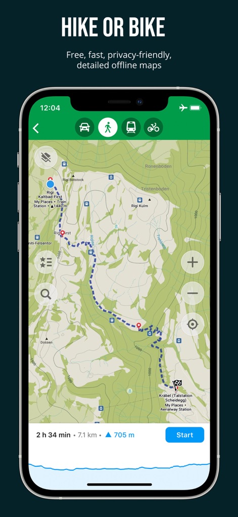
이 앱은 사용자가 하이킹이나 자전거 경로를 쉽게 계획할 수 있도록 다양한 교통 수단 아이콘과 상세한 고도 프로필을 보여줍니다.
최적의 아웃도어 경로
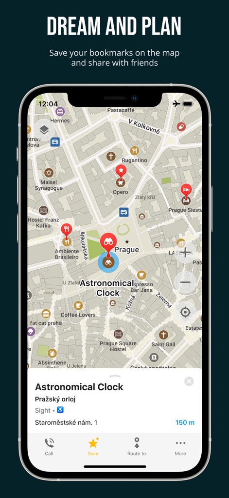
이 도구는 사용자가 지도에 즐겨찾는 장소를 핀으로 표시하고, 천문 시계와 같은 장소에 대한 상세한 정보를 한눈에 볼 수 있도록 합니다.
즐겨찾기 장소 저장
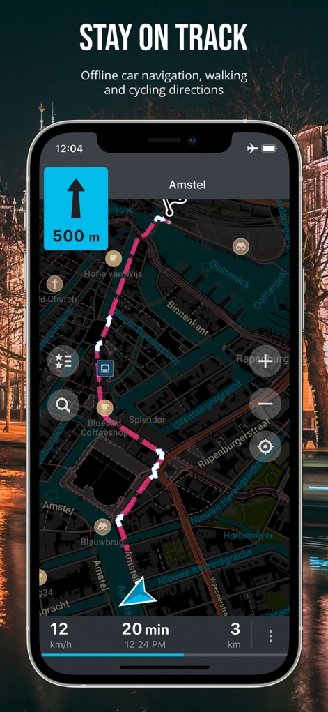
사용자는 이 앱의 어두운 모드에서 500m 앞 방향을 알려주는 선명한 화살표와 실시간 주행 통계를 통해 야간에도 원활하게 길을 안내받을 수 있습니다.
정확한 오프라인 길안내
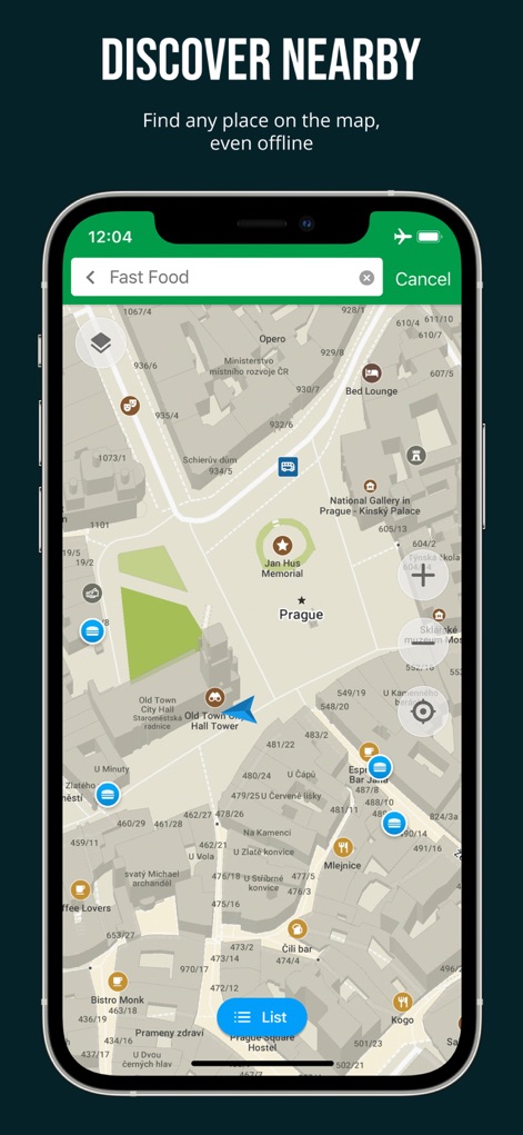
이 도구는 사용자가 검색창에 특정 카테고리를 입력하여 주변의 패스트푸드점과 같은 관심 지점을 지도에 즉시 표시할 수 있게 합니다.
주변 장소 탐색
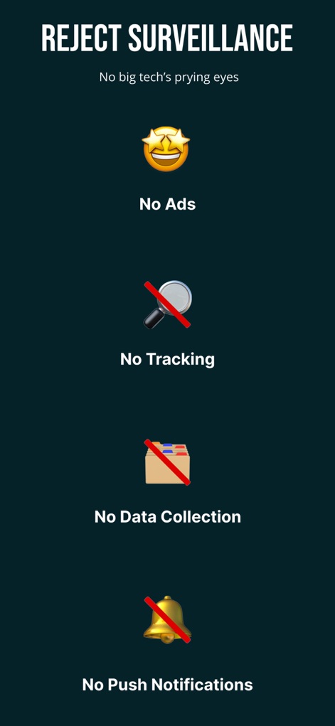
이 앱은 광고 없음 정책과 데이터 수집 방지 정책을 명시하여 사용자의 개인 정보를 최우선으로 보호한다는 점을 시각적으로 강조합니다.
개인 정보 보호 최우선
설명
Download
비슷한 앱
유사한 기능과 사용자 경험을 가진 앱

AllTrails: Hike, Bike & Run
AllTrails, Inc.

Pedometer++
Cross Forward Consulting, LLC

Gaia GPS: Mobile Trail Maps
Trailbehind, INC.

Offline hiking maps: Mapy.com
Seznam.cz a.s.

Hiking Map Poland
Mapa Turystyczna sp. z o.o.

MapOut
Valnova GmbH

FarOut: Offline GPS Trail Maps
Atlas Guides DE, Inc.

Norgeskart
Norgeskart AS

GPX viewer - map
Lucas den Otter
이 페이지는 앱이나 개발자의 공식 페이지가 아니며, 정보 제공 및 논평을 목적으로 작성된 독립 편집 간행물입니다. 명시적으로 달리 언급되지 않는 한, 해당 앱이나 개발자는 MWM, Apple, Google Play, 앱 퍼블리셔 또는 앱 개발자와 제휴, 보증, 후원, 승인 또는 공식적으로 연결되어 있지 않으며, 이 페이지의 어떤 내용도 해당 앱이 MWM의 서비스를 사용하여 개발되었음을 의미하지 않습니다. 모든 상표, 로고, 스크린샷 및 기타 콘텐츠는 해당 소유자의 자산입니다.