이 페이지는 앱이나 개발자의 공식 페이지가 아니며, 정보 제공 및 논평을 목적으로 작성된 독립 편집 간행물입니다. 명시적으로 달리 언급되지 않는 한, 해당 앱이나 개발자는 MWM, Apple, Google Play, 앱 퍼블리셔 또는 앱 개발자와 제휴, 보증, 후원, 승인 또는 공식적으로 연결되어 있지 않으며, 이 페이지의 어떤 내용도 해당 앱이 MWM의 서비스를 사용하여 개발되었음을 의미하지 않습니다. 모든 상표, 로고, 스크린샷 및 기타 콘텐츠는 해당 소유자의 자산입니다.

Spyglass
당신은 길을 잃지 않는 자가 됩니다. Spyglass는 단순한 앱이 아니라, 모든 환경에서 당신의 시야를 넓히는 도구입니다. 정확하고, 무자비하게 길을 안내하죠.
다운로드
500k+사용자 평점
총 평가 수
6.4K개발사
카테고리
Navigation지원 언어
12최신 버전
3.31.5크기
66.1 MB출시일
2009년 10월 4일고급 야외 활동 전문가 및 전술 요원을 위한 정밀 내비게이션 도구
Spyglass 앱의 주요 기능 분석
오프라인 지도 및 내비게이션
이 앱은 오프라인 환경에서 지도를 사용하고 목표물을 추적할 수 있도록 하여, 인터넷 연결 없이도 완벽한 내비게이션 기능을 제공합니다.
정밀 GPS 데이터 및 측정
이 도구는 수십 가지 형식의 좌표, 고도, 코스, 속도 등 상세하고 실시간 GPS 데이터를 제공하며, 임페리얼, 미터법, 해상 및 측량 단위로 측정할 수 있습니다.
고급 나침반 및 자이로 나침반
사용자는 독점적인 정확도 향상 기술과 특수 나침반 모드를 통해 가장 진보되고 정확한 디지털 나침반 기능을 활용할 수 있습니다.
증강 현실(AR) 내비게이션 및 목표 추적
이 앱은 3D 환경에서 증강 현실을 사용하여 카메라 또는 지도 위에 실시간으로 객체의 위치, 정보 및 방향을 오버레이하여 표시합니다. 여러 대상을 동시에 추적하고 거리, 방향, 고도 및 예상 도착 시간 등 상세 정보를 보여줍니다.
항성, 태양 및 달 추적
이 도구는 별, 태양 및 달의 위치를 아크초 단위의 정확도로 추적하여, 사용자가 나침반을 최대 정확도로 보정하는 기준으로 활용할 수 있게 해줍니다.
광학 거리 측정기
사용자는 스나이퍼 조준경과 유사한 거리 측정 레티클을 사용하여 객체까지의 거리를 실시간으로 측정할 수 있습니다.
육분의, 각도 계산기 및 경사계
이 앱은 객체의 높이와 거리를 시각적으로 측정하고 계산할 수 있는 기능을 제공하여, 정밀한 분석을 돕습니다.
사용자 지정 장소 및 경유지 관리
이 도구는 사용자가 자신만의 장소와 경유지를 저장하고, 지도에 표시하며, 나중에 정밀하게 내비게이션할 수 있게 해줍니다.
자주 묻는 질문
에 대해 알아야 할 모든 것 Spyglass
What is Spyglass?
Spyglass is an essential offline GPS app for outdoors and off-road navigation. It provides numerous tools including a hi-tech compass, offline maps, GPS receiver, altimeter, and augmented reality features.
Does Spyglass work offline?
Yes, Spyglass operates as an offline GPS app. It provides offline maps optimized for retina displays, which users can download for navigation without an internet connection.
What navigation tools are included in the Spyglass app?
Spyglass includes a hi-tech compass, gyrocompass, GPS receiver, waypoint tracker, speedometer, altimeter, optical rangefinder, sextant, inclinometer, and a Sun, Moon, and star finder. It also features augmented reality.
Can Spyglass track stars, the Sun, and the Moon?
Yes, Spyglass tracks the positions of stars, the Sun, and the Moon with arc second precision. Users can utilize these celestial bodies to calibrate the compass for maximum accuracy.
How does Spyglass use augmented reality (AR)?
Spyglass operates in 3D and uses augmented reality to display real-time object positions, information, and directions. It overlays this data directly over the camera view or maps.
Can I save custom locations in Spyglass?
Yes, Spyglass allows users to save current positions, add points from maps, and manually enter location coordinates. It also offers a built-in star catalog for saving celestial objects.
What kind of GPS data does Spyglass display?
Spyglass displays detailed real-time GPS data including coordinates in dozens of formats, altitude, course, current, maximum, and vertical speed. It supports imperial, metric, nautical, and surveying units.
Does Spyglass offer different unit measurements?
Yes, Spyglass supports various unit measurements. Users can select imperial, metric, nautical, and surveying units for speed, distance, and other GPS data, configurable in settings.
What is Spyglass PLUS?
Spyglass PLUS is an enhanced version offering specific map sources tailored for activities like hiking, cycling, and skiing. It is available as a subscription.
How do I manage my Spyglass PLUS subscription?
You can turn off automatic renewal for Spyglass PLUS at any time in your iTunes Account Settings after purchase. The subscription expires at the end of the current period upon cancellation.
Can Spyglass measure distances to objects?
Yes, Spyglass features an optical rangefinder to measure distances to objects in real-time, using a reticle similar to sniper sights. It also offers a sextant for visual distance and dimension calculations.
Does Spyglass allow sharing of locations?
Yes, Spyglass allows users to copy, paste, and share locations, coordinates, and map links. It supports multiple formats for convenient sharing.
다음 스크린샷과 설명은 앱의 공식 스토어 목록에서 직접 가져온 것이며 앱 개발자의 자산입니다.
앱 스토어
스크린샷

이 앱은 실시간 GPS 데이터와 상세 도시 지도를 결합하여 사용자에게 정밀한 위치 정보와 목표물 추적 기능을 제공합니다.
정밀 지도 내비게이션
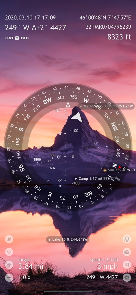
산과 호수의 풍경 위에 증강 현실 오버레이를 통해 사용자는 목표물과 해 뜨는 방향을 직관적으로 추적할 수 있습니다.
몰입형 AR 탐색

이 도구는 위성 지도 보기를 통해 광활한 숲 지역에서 'Jeep' 및 'Antenna #1'과 같은 사용자 지정 목표물을 효율적으로 추적합니다.
오프라인 지도 추적

사용자는 달 및 태양 추적 기능을 활용하여 정밀 나침반으로 자신의 위치를 파악하고 방향을 설정할 수 있습니다.
천문 나침반 안내

이 앱은 지형도 상세 보기를 제공하여 'Eibsee'와 같은 목표물까지의 경로를 계획하고 고도 정보를 표시하여 사용자의 탐색을 돕습니다.
복잡한 지형 탐색

사용자는 'Decoy'와 같은 저장된 목적지 목록과 'Aldebaran'과 같은 별자리 위치 정보를 통해 다양한 탐색 지점을 손쉽게 관리할 수 있습니다.
목적지 관리 허브

이 도구는 실시간 별 위치 표시와 증강 현실 별자리를 통해 사용자가 'Betelgeuse'와 같은 주요 별을 기준으로 정확하게 항해할 수 있도록 지원합니다.
별자리 항해 도구

이 앱은 상세 GPS 좌표와 실시간 속도 및 고도 등 중요한 모든 탐색 데이터를 한눈에 볼 수 있는 명확한 대시보드를 제공합니다.
실시간 데이터 대시보드

사용자는 위성 신호 강도 표시와 위성 위치 극좌표를 통해 연결된 위성 수를 확인하고 GPS 수신 상태를 정확하게 진단할 수 있습니다.
위성 수신 진단

이 도구는 사용자에게 단위 및 좌표 설정을 포함한 다양한 맞춤형 옵션을 제공하며, 목적지 추적 범위 제어를 통해 탐색 경험을 최적화할 수 있습니다.
맞춤형 설정 제어
설명
Download
비슷한 앱
유사한 기능과 사용자 경험을 가진 앱

AllTrails: Hike, Bike & Run
AllTrails, Inc.

Pedometer++
Cross Forward Consulting, LLC

Organic Maps: Offline Map
Organic Maps OU

Gaia GPS: Mobile Trail Maps
Trailbehind, INC.

Offline hiking maps: Mapy.com
Seznam.cz a.s.

Hiking Map Poland
Mapa Turystyczna sp. z o.o.

MapOut
Valnova GmbH

FarOut: Offline GPS Trail Maps
Atlas Guides DE, Inc.

Norgeskart
Norgeskart AS
이 페이지는 앱이나 개발자의 공식 페이지가 아니며, 정보 제공 및 논평을 목적으로 작성된 독립 편집 간행물입니다. 명시적으로 달리 언급되지 않는 한, 해당 앱이나 개발자는 MWM, Apple, Google Play, 앱 퍼블리셔 또는 앱 개발자와 제휴, 보증, 후원, 승인 또는 공식적으로 연결되어 있지 않으며, 이 페이지의 어떤 내용도 해당 앱이 MWM의 서비스를 사용하여 개발되었음을 의미하지 않습니다. 모든 상표, 로고, 스크린샷 및 기타 콘텐츠는 해당 소유자의 자산입니다.