이 페이지는 앱이나 개발자의 공식 페이지가 아니며, 정보 제공 및 논평을 목적으로 작성된 독립 편집 간행물입니다. 명시적으로 달리 언급되지 않는 한, 해당 앱이나 개발자는 MWM, Apple, Google Play, 앱 퍼블리셔 또는 앱 개발자와 제휴, 보증, 후원, 승인 또는 공식적으로 연결되어 있지 않으며, 이 페이지의 어떤 내용도 해당 앱이 MWM의 서비스를 사용하여 개발되었음을 의미하지 않습니다. 모든 상표, 로고, 스크린샷 및 기타 콘텐츠는 해당 소유자의 자산입니다.

专业指南针-GPS北斗定位海拔测量导航
이 앱은 당신의 스마트폰을 정밀한 생존 도구로 변모시킵니다. 단순히 방향을 가리키는 것을 넘어, 주변 환경의 모든 물리적 데이터를 해독하는 능력을 부여합니다.
다운로드
500k+사용자 평점
총 평가 수
463개발사
카테고리
Utilities지원 언어
3최신 버전
1.1.0크기
42.6 MB출시일
2025년 9월 21일정밀한 위치 기반 기능을 통한 아웃도어 및 일상 활용성 평가
앱 '专业指南针-GPS北斗定位海拔测量导航' 분석 보고서
실시간 고도 및 위경도 측정
이 앱은 사용자가 현재 위치의 정확한 고도와 위경도 좌표를 실시간으로 확인할 수 있도록 하여, 지리 정보를 정밀하게 파악하고 아웃도어 탐험 및 여행 기록을 더욱 전문적으로 만들어 줍니다.
고정밀 전자 나침반
이 도구는 내장된 고정밀 전자 나침반을 통해 실시간으로 정확한 방향을 지시하여, 사용자가 산악 지형이나 도시 골목길 어디에서든 길을 잃지 않고 나아갈 수 있도록 돕습니다.
실시간 날씨 정보
이 앱은 현재 위치의 실시간 날씨 정보(온도, 습도, 풍력 등)를 제공하여, 사용자가 시의적절하게 여행 계획을 세우고 변화하는 환경에 대비할 수 있게 합니다.
위치 정보 워터마크 카메라
이 앱은 사진 촬영 시 자동으로 시간, 장소, 고도, 위경도 워터마크를 추가하여, 사용자가 여행의 멋진 순간들을 정확한 지리적 정보와 함께 기록하고 공유할 수 있도록 합니다.
자주 묻는 질문
에 대해 알아야 할 모든 것 专业指南针-GPS北斗定位海拔测量导航
What is 专业指南针-GPS北斗定位海拔测量导航?
专业指南针-GPS北斗定位海拔测量导航 is a versatile outdoor navigation and life assistant app. It features an accurate compass, real-time altitude/coordinates, a smart leveler, real-time weather, and a watermark camera.
Does 专业指南针-GPS北斗定位海拔测量导航 provide an accurate compass?
Yes, the 专业指南针 app integrates a high-precision electronic compass. It provides real-time direction, ensuring users always know their heading, whether in mountains or cities.
Can 专业指南针 display current altitude and coordinates?
Yes, the 专业指南针 app displays real-time altitude, longitude, and latitude coordinates. This feature allows users to precisely understand their geographical information during outdoor exploration and travel.
Does the 专业指南针 app include a level measurement tool?
Yes, the 专业指南针 app includes a smart leveler tool. It easily detects the horizontal state of surfaces, which is useful for home decorating and equipment installation tasks.
How does 专业指南针 help with weather information?
The 专业指南针 app provides current location weather details like temperature, humidity, and wind power. This real-time data helps users plan their outings and travels effectively.
Can I add location data to photos using 专业指南针?
Yes, the 专业指南针 app has a watermark camera feature. It automatically embeds time, location, altitude, and coordinates onto photos, documenting every travel moment with geographical context.
What are the benefits of a VIP membership in 专业指南针?
Subscribing to VIP membership in 专业指南针 unlocks all premium features and high-definition output capabilities. This enhances the app's functionality for a more advanced user experience.
How do I manage or cancel my 专业指南针 subscription?
To manage or cancel your 专业指南针 subscription, navigate to Apple's "Settings" → "iTunes Store & App Store" → "Apple ID" → "View Apple ID" → "Account Settings" → "Subscriptions".
Where can I find the privacy policy for 专业指南针?
The privacy policy for 专业指南针 is available via a direct link. Users can access comprehensive information regarding data handling and privacy practices at https://docs.qq.com/doc/DY1VRd2ZFaGx4eFFo.
다음 스크린샷과 설명은 앱의 공식 스토어 목록에서 직접 가져온 것이며 앱 개발자의 자산입니다.
앱 스토어
스크린샷
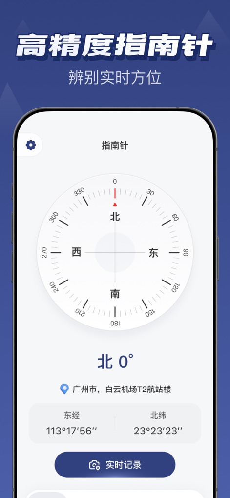
이 스크린샷은 '북 0°'를 가리키는 고정밀 디지털 나침반과 현재 위치의 정확한 '동경 113°17'56", 북위 23°23'23"' 좌표를 명확하게 보여줍니다.
정밀 나침반 기능
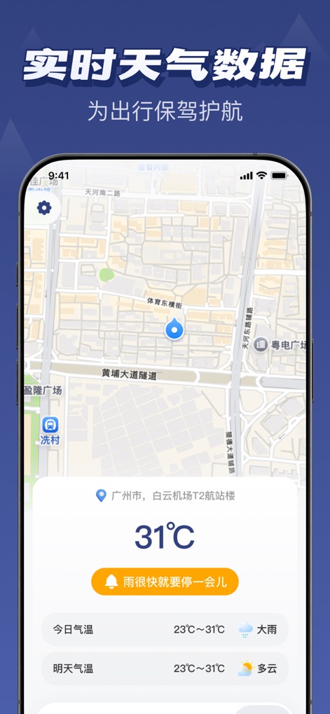
이 스크린샷은 광저우의 현재 온도가 '31°C'임을 보여주며, 곧 '비가 그칠 것'이라는 예보와 함께 상세한 일일 날씨 데이터를 제공합니다.
실시간 날씨 정보
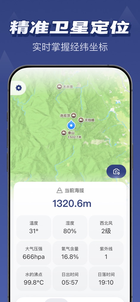
이 스크린샷은 사용자의 '현재 고도 1320.6m'를 명확히 보여주고, '온도 31°' 및 '습도 80%'와 같은 다양한 환경 데이터를 한눈에 제공합니다.
정밀 위성 위치
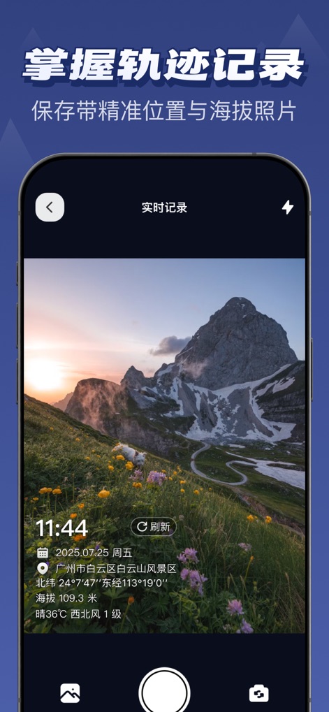
사용자는 이 기능을 통해 아름다운 산악 풍경 사진에 '날짜, 시간 및 위치' 정보와 함께 '고도 109.3m' 및 날씨 데이터를 자동으로 추가할 수 있습니다.
워터마크 사진 기록
설명
Download
비슷한 앱
유사한 기능과 사용자 경험을 가진 앱

Realtime Altimeter
Zhenlai Xia

Travel Camera & Compass
Ha Nguyen

compass-latitude and longitude
美霞 熊

Compass ×
DOUBLE U s.r.o.

GPS Altitude-海拔表
祥琦 孔

Compass: GPS & Altimeter
Shanghai BRC Internet Technology Co., Ltd.

Travel Altimeter & Elevation
BranchenKing Ltd.

Compass - GPS positioning
嘉 罗

Compass360X-GPS Speedometer
卫豪 吴
이 페이지는 앱이나 개발자의 공식 페이지가 아니며, 정보 제공 및 논평을 목적으로 작성된 독립 편집 간행물입니다. 명시적으로 달리 언급되지 않는 한, 해당 앱이나 개발자는 MWM, Apple, Google Play, 앱 퍼블리셔 또는 앱 개발자와 제휴, 보증, 후원, 승인 또는 공식적으로 연결되어 있지 않으며, 이 페이지의 어떤 내용도 해당 앱이 MWM의 서비스를 사용하여 개발되었음을 의미하지 않습니다. 모든 상표, 로고, 스크린샷 및 기타 콘텐츠는 해당 소유자의 자산입니다.