This page is not an official page of the app or its developer, but an independent editorial publication created for informational and commentary purposes. Unless expressly stated otherwise, neither the app nor its developer is affiliated with, endorsed by, sponsored by, authorized by, or otherwise officially connected with MWM, Apple, Google Play, the app publisher, or the app's developer, and nothing on this page implies that the app was developed using MWM's services. Any trademarks, logos, screenshots, and other content remain the property of their respective owners.

Aqua Map Boating
The trusted companion for coastal cruisers and Great Loopers. Navigate safely with official NOAA charts, exclusive USACE shallow-water surveys, and real-time AIS integration designed for the serious mariner.
Downloads
715K+User Rating
Total Ratings
12K+Publisher
Category
NavigationLocales
8Latest Version
52.7Size
167.4 MBFirst Released
Oct 15, 2014Navigate with Professional Confidence
The ultimate maritime tool for serious captains, combining official NOAA charts with advanced instrument integration and exclusive shallow-water intelligence.
Exclusive Depth Intelligence
Navigate shallow waters safely with integrated U.S. Army Corps of Engineers (USACE) surveys and real-time local updates.
Seamless NMEA & AIS Integration
Turn your iPad into a professional bridge by syncing with your onboard sensors for AIS collision detection and live instrument data.
Frequently Asked Questions
Everything you need to know about Aqua Map Boating
Does Aqua Map Boating offer a free trial?
Yes, Aqua Map Boating offers a free 14-day trial for all its subscriptions. This allows users to evaluate the app's features before purchase.
Does Aqua Map Boating use official nautical charts?
Yes, Aqua Map Boating utilizes official NOAA nautical charts, which are updated weekly. This ensures navigators have access to current and reliable marine data.
Can I use Aqua Map Boating charts offline?
Yes, Aqua Map Boating allows users to download map areas for offline use. This requires a chart subscription for the desired navigation region.
Does Aqua Map Boating connect to NMEA instruments?
Yes, Aqua Map Boating connects to onboard instruments like autopilot, depth sounder, and GPS via WiFi. This feature is available with the Expert subscription.
Does Aqua Map Boating have route planning features?
Yes, Aqua Map Boating provides both manual and automatic route planning modes. Users can switch between these options to suit their navigation preferences.
Can I record GPS tracks with Aqua Map Boating?
Yes, Aqua Map Boating allows users to record their GPS tracks. This feature enables review and analysis of past voyages directly within the app.
How do I share navigation data in Aqua Map Boating?
Aqua Map Boating enables storage and sharing of navigation data, including markers, routes, and recorded tracks. This supports community interaction and record-keeping.
Does Aqua Map Boating provide tides and currents information?
Yes, Aqua Map Boating displays tides and currents predictions and simulations. This feature aids users in understanding water conditions for safer navigation.
Does Aqua Map Boating include an Anchor Alarm?
Yes, Aqua Map Boating includes an Anchor Alarm feature to enhance safety. It alerts users if their vessel drifts outside a predefined safe radius.
What is Live Sharing in Aqua Map Boating?
Live Sharing in Aqua Map Boating allows users to interact with the Aqua Map community. It facilitates real-time information exchange among mariners.
Does Aqua Map Boating integrate with other marine communities?
Yes, Aqua Map Boating integrates with other marine communities. It displays points of interest from "ActiveCaptain" and "Waterway Guide" to provide comprehensive local knowledge.
Does Aqua Map Boating offer marine forecasts?
Yes, the Expert subscription of Aqua Map Boating includes marine forecasts. These cover wind, waves, currents, gusts, salinity, and sea surface temperature for any point on the map.
Can Aqua Map Boating overlay satellite images?
Yes, the Aqua Map Boating Expert subscription allows users to overlay satellite images onto their nautical charts. This provides additional visual context for navigation.
Does Aqua Map Boating have advanced anchor monitoring?
Yes, the Expert subscription in Aqua Map Boating features Advanced AnchorLink. This includes anchorage mirroring and provides email or Telegram notifications for enhanced peace of mind.
Does Aqua Map Boating include AIS with collision detection?
Yes, the Expert subscription provides AIS with automatic collision detection. This feature enhances safety by alerting users to potential vessel conflicts on the water.
What is Route Explorer in Aqua Map Boating?
Route Explorer, part of the Aqua Map Boating Expert subscription, provides real-time information on all elements along a user's planned route. This assists dynamic navigation.
What additional data does Aqua Map Boating's Master subscription offer?
The Aqua Map Boating Master subscription includes all Expert features plus local data. This encompasses US Army Corps of Engineers surveys and Coast Guard navaids for specific regions.
How do I access nautical charts in Aqua Map Boating?
To access nautical charts in Aqua Map Boating, users must purchase a chart subscription for their desired area of interest. Charts are fundamental for navigation.
What are the subscription options for Aqua Map Boating?
Aqua Map Boating requires a chart subscription, and users can optionally add an Expert or Master subscription. These unlock additional navigation features and data.
How are Aqua Map Boating subscriptions paid?
Aqua Map Boating subscription payments are processed through the user's Apple ID account. This integrates with the standard Apple App Store purchasing system.
Do Aqua Map Boating subscriptions auto-renew?
Yes, Aqua Map Boating annual subscriptions automatically renew. Users must cancel at least 24 hours before the expiration date to prevent renewal.
How do I manage my Aqua Map Boating subscription?
Users can manage their Aqua Map Boating subscription and disable automatic renewal within the account settings section of their Apple ID after purchase.
Where can I find the Terms of Use for Aqua Map Boating?
The Terms of Use for Aqua Map Boating are available on their official website at https://www.aquamap.app/terms-and-conditions.
Where can I find the Privacy Policy for Aqua Map Boating?
The Privacy Policy for Aqua Map Boating is accessible on their official website at https://www.aquamap.app/privacy-policy.
The following screenshots and description are sourced directly from the app's official store listing and are the property of the app developer.
App Store
Screenshots
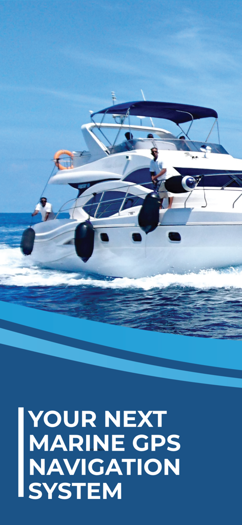
Luxury motor yacht cruising on blue water with marine GPS navigation system text
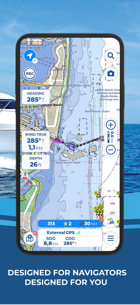
Aqua Map Boating app displaying a nautical chart with real-time navigation data near Miami Beach
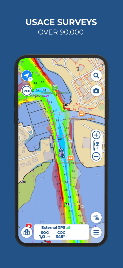
Aqua Map Boating app screen showing USACE survey data for safe navigation in shallow waters
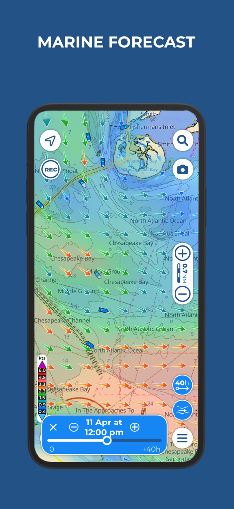
Aqua Map Boating app interface showing marine forecast with wind and current speed vectors over a nautical chart of Chesapeake Bay.
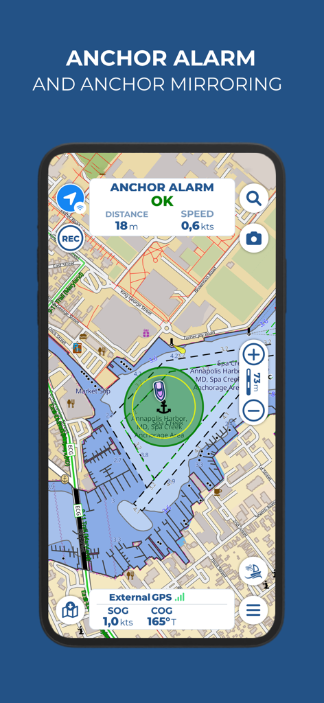
Aqua Map Boating mobile app interface displaying the anchor alarm feature on a nautical chart of Annapolis Harbor

Aqua Map Boating app showing a tide and current graph for Chesapeake Bay Virginia with sunrise and sunset times
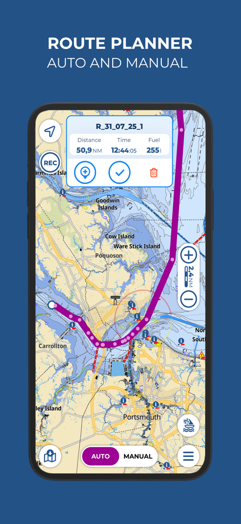
Aqua Map Boating app interface showing the nautical route planner with estimated distance, time, and fuel consumption on a maritime chart.
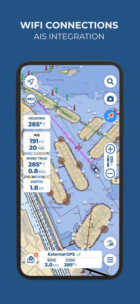
Aqua Map Boating app interface showing AIS integration and real-time maritime navigation data
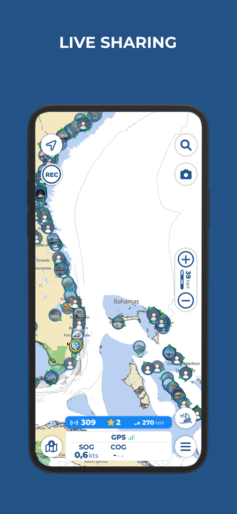
Aqua Map Boating mobile app interface showing the live sharing feature with real time vessel locations on a nautical chart of Florida and the Bahamas
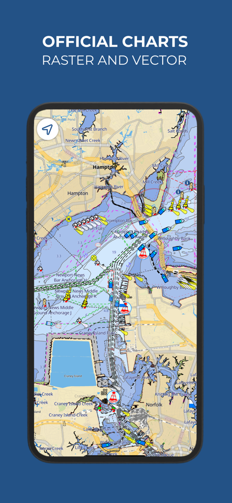
Aqua Map Boating app showing official raster and vector nautical charts with boat positions and maritime navigation data
Description
Download
More Like This
Apps with similar features and user experience

PredictWind — Marine Forecasts
PredictWind Limited

Navily
The Navigation Family

Argo - Boating Navigation
Argo Navigation, LLC

SEAiq Pilot
Sakhalin, LLC

Maptrails
Pasi Salenius

KartenWerft NavGo 2.0
KartenWerft GmbH

MarineTraffic - Ship Tracking
MARINETRAFFIC APPLICATIONS LTD

Wavve Boating: Marine Boat GPS
Wavve Boating Inc

Savvy Navvy Boating Navigation
SAVVY NAVVY LTD
This page is not an official page of the app or its developer, but an independent editorial publication created for informational and commentary purposes. Unless expressly stated otherwise, neither the app nor its developer is affiliated with, endorsed by, sponsored by, authorized by, or otherwise officially connected with MWM, Apple, Google Play, the app publisher, or the app's developer, and nothing on this page implies that the app was developed using MWM's services. Any trademarks, logos, screenshots, and other content remain the property of their respective owners.