This page is not an official page of the app or its developer, but an independent editorial publication created for informational and commentary purposes. Unless expressly stated otherwise, neither the app nor its developer is affiliated with, endorsed by, sponsored by, authorized by, or otherwise officially connected with MWM, Apple, Google Play, the app publisher, or the app's developer, and nothing on this page implies that the app was developed using MWM's services. Any trademarks, logos, screenshots, and other content remain the property of their respective owners.

MarineTraffic - Ship Tracking
Join over 7 million professionals and enthusiasts to monitor 300,000+ vessels daily with the world's largest AIS network, nautical charts, and advanced weather forecasts.
Downloads
7M+User Rating
Total Ratings
284K+Publisher
Category
TravelLocales
1Latest Version
4.1.93Size
78.9 MBFirst Released
Oct 8, 2012Master the Seas with Global Intelligence
From real-time vessel positions to professional-grade nautical data, MarineTraffic empowers your maritime journey with precision and peace of mind.
Real-Time Vessel Intelligence
Track over 300,000 ships daily with live AIS data, precise port arrival times, and automated fleet management for professional-grade logistics.
Instant AR Identification
Satisfy your curiosity by pointing your camera at the horizon to instantly identify ships, ports, and lighthouses using advanced Augmented Reality.
Frequently Asked Questions
Everything you need to know about MarineTraffic - Ship Tracking
What is MarineTraffic - Ship Tracking?
MarineTraffic - Ship Tracking is an app that displays near real-time positions of ships and yachts worldwide. It uses the largest network of land-based AIS receivers, covering most major ports and shipping routes for vessel tracking.
Does MarineTraffic - Ship Tracking provide real-time vessel tracking?
Yes, MarineTraffic - Ship Tracking provides near real-time vessel tracking. Over 300,000 vessels report their positions daily via the MarineTraffic AIS network, allowing users to view them live on the map.
Can I view weather forecasts in the MarineTraffic - Ship Tracking app?
Yes, MarineTraffic - Ship Tracking provides live wind and 48-hour wind forecasts directly on the map. An additional Weather Maps Layers subscription offers comprehensive real-time and forecast weather information.
How does the Augmented Reality (AR) tool work in MarineTraffic?
The MarineTraffic app features an Augmented Reality tool. Users point their device's camera to the horizon to identify vessels, ports, and lighthouses, receiving instant details like name, flag, speed, and distance.
What are the subscription options available in MarineTraffic - Ship Tracking?
MarineTraffic - Ship Tracking offers several auto-renewable subscriptions: Starter Plan, Nautical Charts, Weather Maps Layers, and Advanced Density Maps. These are available with both monthly and annual payment options.
What is the cost of the Starter Plan for MarineTraffic - Ship Tracking?
The Starter Plan Annual subscription for MarineTraffic - Ship Tracking costs $9.99 (USD). It renews annually and unlocks extensive features such as extended vessel and port details, vessel track, and Augmented Reality.
Can MarineTraffic - Ship Tracking provide port arrival and departure information?
Yes, MarineTraffic - Ship Tracking provides live port arrivals and departures for over 4,000 ports and marinas. It also shows current port conditions and estimated time of arrival (ETA) for vessels.
Does MarineTraffic - Ship Tracking offer a way to track vessels beyond land-based AIS?
Yes, MarineTraffic - Ship Tracking offers satellite tracking for vessels beyond the range of land-based AIS stations. This functionality is accessible through an in-app purchase called ACCESS PLUS 24.
How can I manage my subscriptions for the MarineTraffic app?
Users can manage MarineTraffic subscriptions and turn off auto-renewal by visiting their Account Settings after purchase. Payments are charged directly to the linked iTunes Account.
Does MarineTraffic - Ship Tracking allow users to plan routes?
Yes, MarineTraffic - Ship Tracking includes a ROUTE PLANNER tool. Users can plan routes directly on the map, accurately measure distances, and calculate estimated times of arrival (ETA).
What information is included in Nautical Charts in MarineTraffic?
Nautical Charts in MarineTraffic provide pilotage information, including sea bed details, sea marks, and landmarks. They also detail port specifics like berths, dry docks, buoy, light, and lighthouse positions.
Can I receive notifications for vessels and ports in MarineTraffic?
Yes, MarineTraffic - Ship Tracking supports push notifications for vessels and ports. Users can customize alerts for various events, such as changes in AIS destination or new photo uploads.
The following screenshots and description are sourced directly from the app's official store listing and are the property of the app developer.
App Store
Screenshots
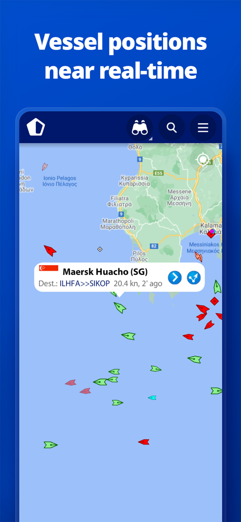
MarineTraffic app interface showing real-time vessel positions and ship details on a live map
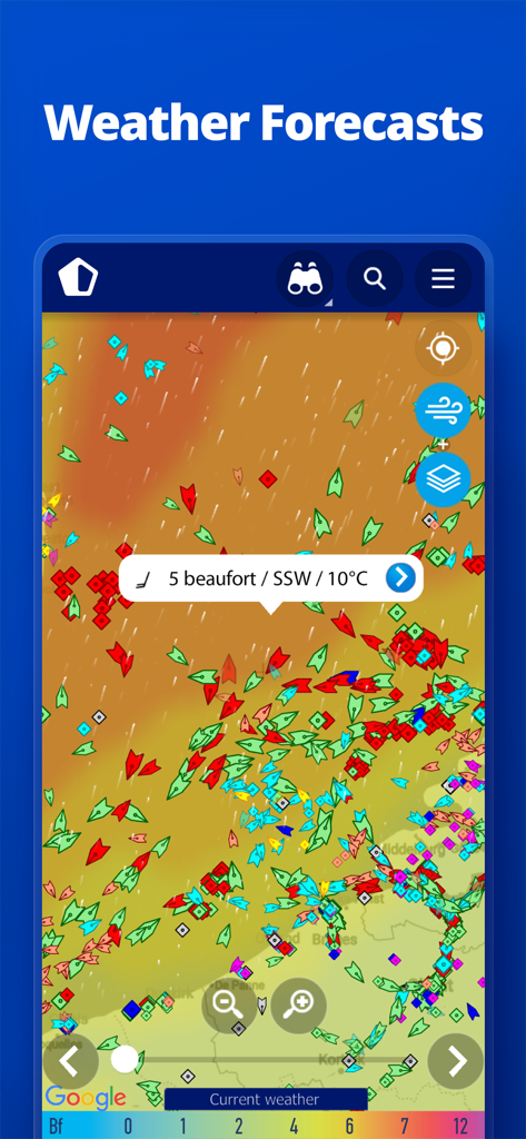
MarineTraffic app display showing ship positions and real-time marine weather forecast with wind and temperature data
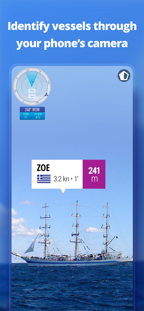
Augmented reality feature in MarineTraffic app identifying a ship through the phone camera
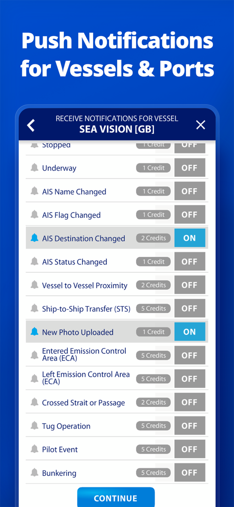
Interface of MarineTraffic app showing custom notification settings for a vessel including AIS changes and photo uploads
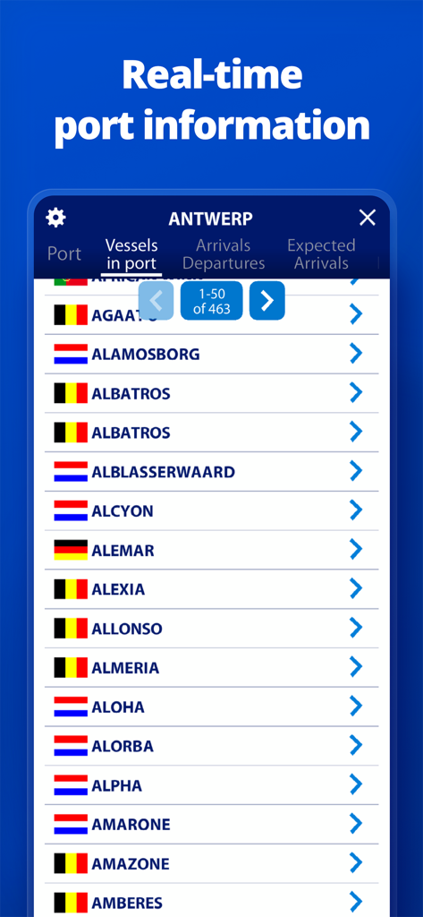
Screenshot of MarineTraffic app showing a list of vessels currently in the port of Antwerp
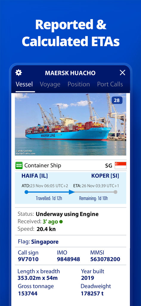
MarineTraffic app interface showing detailed ship information and estimated arrival times for a container vessel.
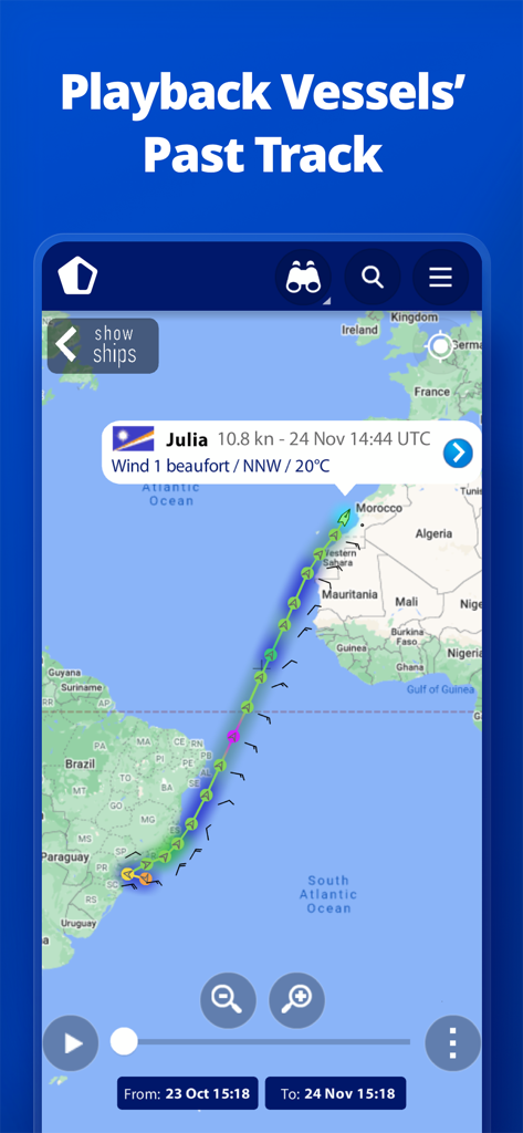
Interface showing the historical playback of a vessel route across the Atlantic Ocean on a map
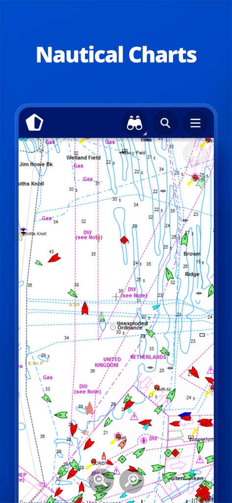
MarineTraffic app interface showing detailed nautical charts with real-time ship tracking and navigation symbols.
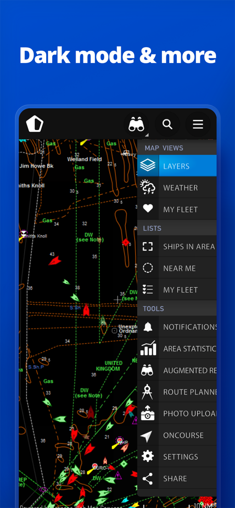
MarineTraffic app interface showing a nautical map in dark mode with vessel icons and a side menu listing features like weather and route planner.
Description
Download
More Like This
Apps with similar features and user experience

PredictWind — Marine Forecasts
PredictWind Limited

Navily
The Navigation Family

Argo - Boating Navigation
Argo Navigation, LLC

SEAiq Pilot
Sakhalin, LLC

Maptrails
Pasi Salenius

KartenWerft NavGo 2.0
KartenWerft GmbH

Wavve Boating: Marine Boat GPS
Wavve Boating Inc

Savvy Navvy Boating Navigation
SAVVY NAVVY LTD

Aqua Map Boating
GEC s.r.l.
This page is not an official page of the app or its developer, but an independent editorial publication created for informational and commentary purposes. Unless expressly stated otherwise, neither the app nor its developer is affiliated with, endorsed by, sponsored by, authorized by, or otherwise officially connected with MWM, Apple, Google Play, the app publisher, or the app's developer, and nothing on this page implies that the app was developed using MWM's services. Any trademarks, logos, screenshots, and other content remain the property of their respective owners.