This page is not an official page of the app or its developer, but an independent editorial publication created for informational and commentary purposes. Unless expressly stated otherwise, neither the app nor its developer is affiliated with, endorsed by, sponsored by, authorized by, or otherwise officially connected with MWM, Apple, Google Play, the app publisher, or the app's developer, and nothing on this page implies that the app was developed using MWM's services. Any trademarks, logos, screenshots, and other content remain the property of their respective owners.

Aviation weather - METAR & TAF
Make smarter Go/No-Go decisions with instant access to decoded reports and real-time weather maps. Join over 230,000 aviators who trust our reliable, professional-grade data for safe and efficient pre-flight planning.
Downloads
239K+User Rating
Total Ratings
3K+Publisher
Category
WeatherLocales
14Latest Version
3.15.0Size
37.9 MBFirst Released
Jan 4, 2021Precision Weather Tools for Every Pilot
Maximize safety and efficiency with a streamlined interface designed for the unique demands of general aviation.
Instant Decoded Reports
Eliminate guesswork by converting raw METAR and TAF strings into easy-to-read, plain English insights for faster pre-flight planning.
Interactive Route Map
Visualize VFR and IFR conditions across your entire path to make confident Go/No-Go decisions with a single glance.
Frequently Asked Questions
Everything you need to know about Aviation weather - METAR & TAF
What is the "Aviation weather - METAR & TAF" app?
The Aviation weather - METAR & TAF app provides quick and reliable access to local and global aviation weather reports. It displays METAR and TAF messages in a decoded format for pilots.
Does the "Aviation weather - METAR & TAF" app display METAR and TAF messages?
Yes, the Aviation weather - METAR & TAF app displays both METAR and TAF messages. These reports are presented in a decoded, easy-to-understand format for aviation users.
Can users customize units in the "Aviation weather - METAR & TAF" app?
Yes, users can customize all units within the "Aviation weather - METAR & TAF" app. This feature is accessible through the app's settings to meet individual preferences.
Does the "Aviation weather - METAR & TAF" app include a map view?
Yes, the "Aviation weather - METAR & TAF" app features a comprehensive map view. This map provides an overview of flight weather, assisting pilots with planned routes.
Is the "Aviation weather - METAR & TAF" app free to use?
Yes, the "Aviation weather - METAR & TAF" app is free to use because it is ad-supported. Users can opt for an ad-free experience through a paid annual subscription.
How can I remove ads from the "Aviation weather - METAR & TAF" app?
Users can remove ads from the "Aviation weather - METAR & TAF" app by purchasing an annual subscription. This paid option also supports ongoing development.
Where can I find the End User License Agreement (EULA) for "Aviation weather - METAR & TAF"?
The End User License Agreement (EULA) for "Aviation weather - METAR & TAF" is available via a link provided in the app description. It directs to apple.com/legal/internet-services/itunes/dev/stdeula/.
Does the "Aviation weather - METAR & TAF" app show weather for specific airports?
Yes, the "Aviation weather - METAR & TAF" app displays weather for specific airports. For example, Screenshot #1 shows detailed reports for Berlin Brandenburg (EDDB) and Brive-Souillac (LFSL).
What kind of aviation weather information does the "Aviation weather - METAR & TAF" app provide?
The "Aviation weather - METAR & TAF" app provides wind speed and direction, cloud conditions, temperature, dewpoint, and visibility. It also indicates flight categories like VFR, MVFR, and IFR.
The following screenshots and description are sourced directly from the app's official store listing and are the property of the app developer.
App Store
Screenshots
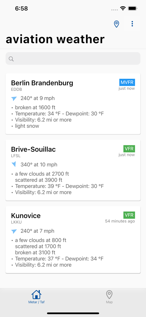
Mobile app interface showing decoded aviation weather reports for multiple airports including wind speed visibility and cloud cover
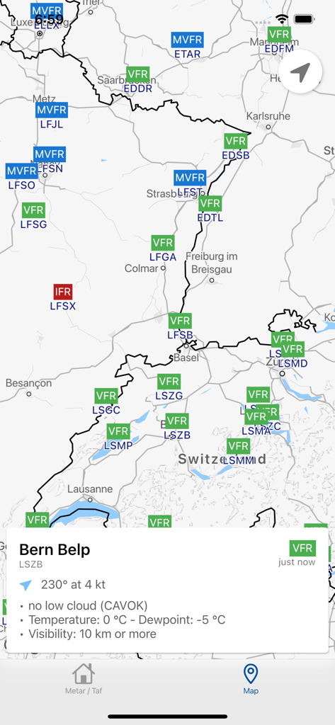
Map view of the Aviation weather app showing VFR and IFR flight conditions for various airports.
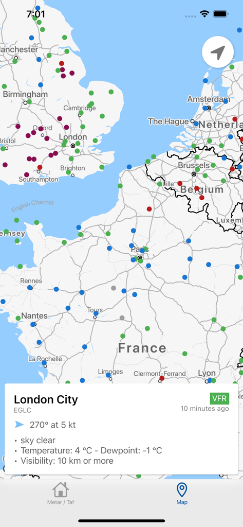
Aviation weather app map view showing METAR data and VFR status for London City airport
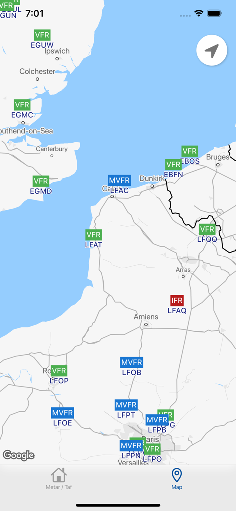
Aviation weather app map showing VFR and IFR flight conditions at various airports
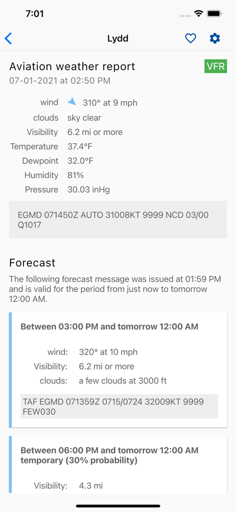
Aviation weather app screen showing decoded METAR and TAF reports for Lydd airport
Description
Download
More Like This
Apps with similar features and user experience

IQAir AirVisual | Air Quality
IQAir AG

CalTopo: Backcountry Mapping
CalTopo LLC

My Altitude
Dayana Networks Ltd

Mountain-Forecast.com
Meteo365 Ltd.

My Tide Times - Tables & Chart
JRustonApps B.V.

UV Index Widget - Worldwide
Bjorn Jenssen

My Aurora Forecast Pro
JRustonApps B.V.

RiverApp - River levels
Florian Bessiere

Dronecast: UAV & Drone Weather
Pinverse LTD
This page is not an official page of the app or its developer, but an independent editorial publication created for informational and commentary purposes. Unless expressly stated otherwise, neither the app nor its developer is affiliated with, endorsed by, sponsored by, authorized by, or otherwise officially connected with MWM, Apple, Google Play, the app publisher, or the app's developer, and nothing on this page implies that the app was developed using MWM's services. Any trademarks, logos, screenshots, and other content remain the property of their respective owners.