This page is not an official page of the app or its developer, but an independent editorial publication created for informational and commentary purposes. Unless expressly stated otherwise, neither the app nor its developer is affiliated with, endorsed by, sponsored by, authorized by, or otherwise officially connected with MWM, Apple, Google Play, the app publisher, or the app's developer, and nothing on this page implies that the app was developed using MWM's services. Any trademarks, logos, screenshots, and other content remain the property of their respective owners.

My Altitude
Get precise altitude, barometric pressure, and coordinates even without a cell signal. The ultimate offline toolkit for hikers, climbers, and outdoor explorers.
Downloads
2M+User Rating
Total Ratings
26K+Publisher
Category
NavigationLocales
1Latest Version
3.0.2Size
28.0 MBFirst Released
Sep 21, 2011Engineered for the Great Outdoors
Accurate altitude, precise coordinates, and essential atmospheric data delivered instantly, even without cell service.
Works Anywhere, No Signal Needed
Get real-time elevation and GPS coordinates deep in the wilderness using built-in sensors, no internet connection required.
Professional-Grade Sensor Accuracy
Utilize your device's barometric sensor and NOAA data files for high-precision altitude tracking and boiling point calculations.
Frequently Asked Questions
Everything you need to know about My Altitude
What is My Altitude?
My Altitude is a free app that uses GPS signals to determine and display your current latitude, longitude, altitude, barometric pressure, and water boiling point. It also offers world altitude and weather information.
Does My Altitude require an internet connection?
No, My Altitude does not require an internet connection to function. It works best in outdoors environments where GPS signals are strong and unobstructed.
How does My Altitude determine elevation?
My Altitude primarily uses the device sensor for elevation determination. Users also have the option to switch and utilize NOAA data files for altitude information.
Can My Altitude display weather information?
Yes, My Altitude displays current weather information. This includes temperature, condition, humidity, wind speed, and wind bearing for your current location.
Can users save altitude data and locations in My Altitude?
Yes, My Altitude allows users to save altitude data for reference. It also enables saving specific locations with their altitude, latitude, and longitude, which can be edited later.
Does My Altitude support both metric and imperial units?
Yes, My Altitude supports both metric (meters) and imperial (feet) systems. Users can change units by tapping on the reported elevation or through the app's settings.
Can My Altitude provide world altitude for any location?
Yes, My Altitude can provide the approximate altitude of any location in the world. Users access this feature through a dedicated 'World Altitude' map interface.
How does My Altitude handle barometric pressure?
My Altitude calculates barometric pressure based on elevation. On newer devices, it can use the built-in barometric sensor directly, a setting configurable by the user.
Is My Altitude a free application?
Yes, My Altitude is a free application with full functionality. An in-app purchase is available to remove advertisements and to support the developers.
Can My Altitude watermark photos with location data?
Yes, My Altitude allows users to take a picture. This picture is then automatically watermarked with the current location's coordinates, altitude, and the local date/time.
The following screenshots and description are sourced directly from the app's official store listing and are the property of the app developer.
App Store
Screenshots
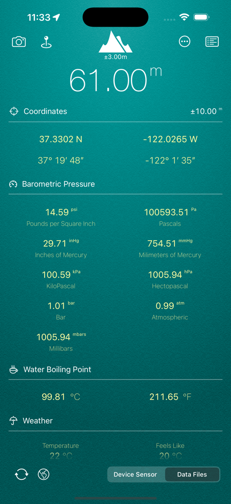
My Altitude app interface displaying altitude coordinates barometric pressure and water boiling point
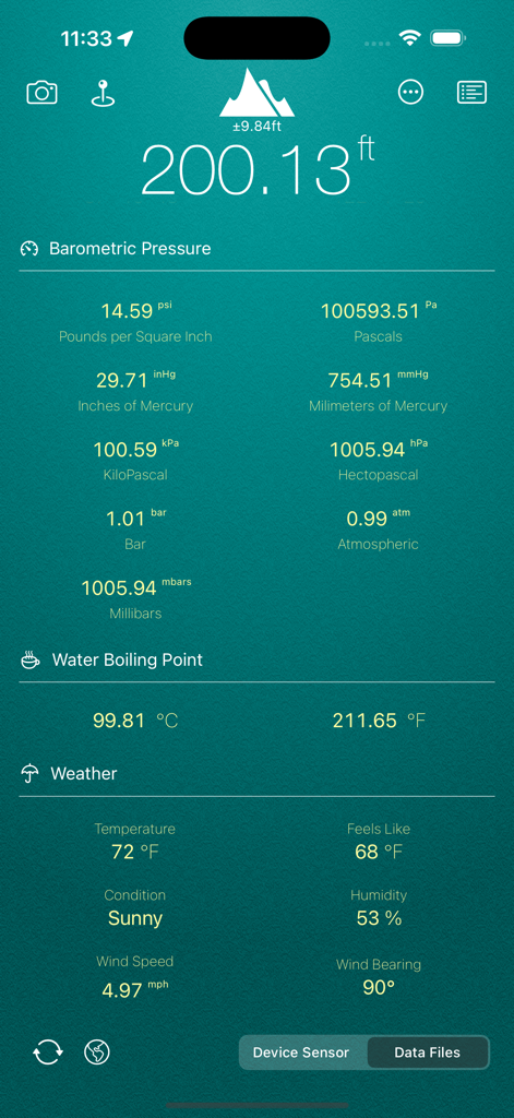
My Altitude app interface showing real-time elevation barometric pressure and local weather
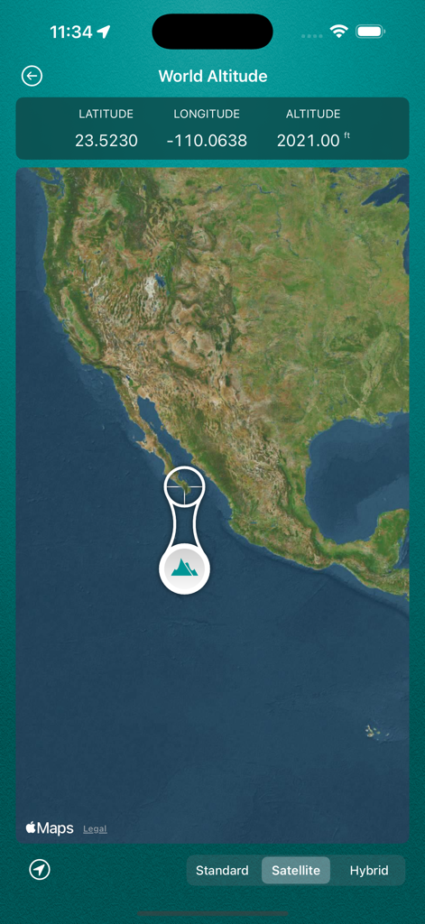
My Altitude app showing World Altitude feature with latitude longitude and altitude coordinates on a satellite map
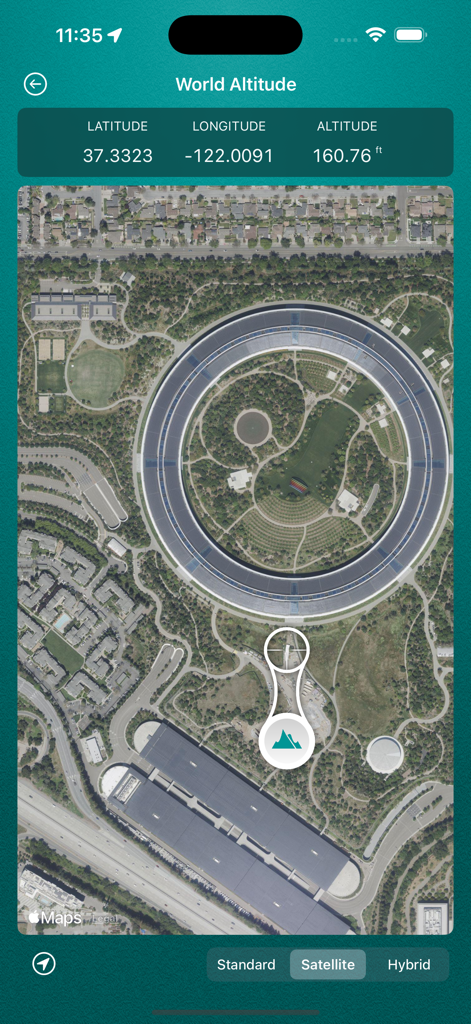
Satellite map view in My Altitude showing latitude longitude and elevation coordinates
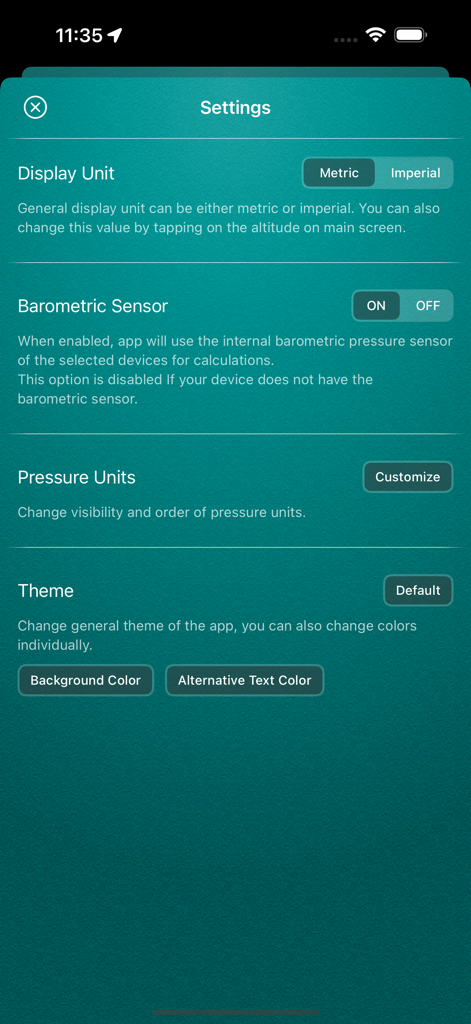
Settings screen of the My Altitude app showing configuration options for display units and barometric sensors
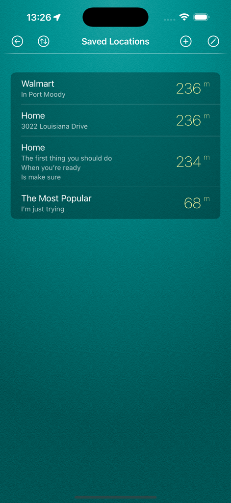
The saved locations screen of the My Altitude app showing a list of places with their recorded elevation in meters.
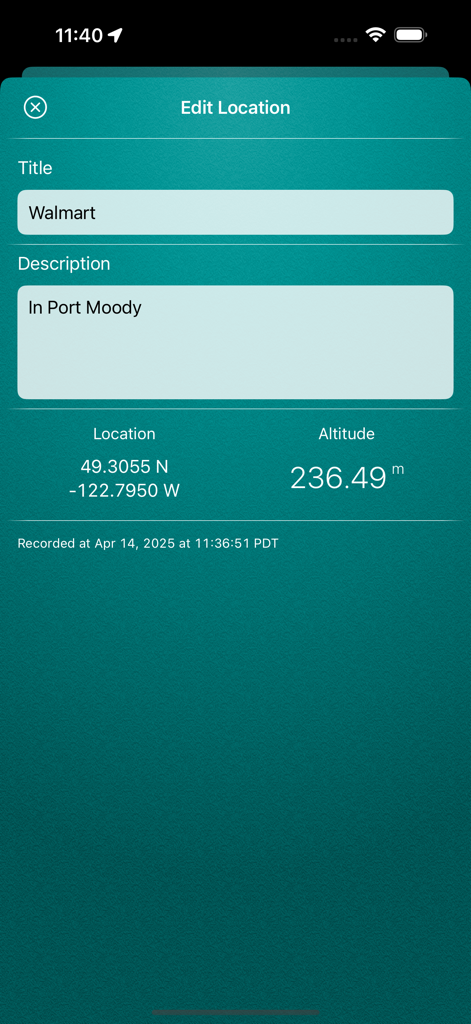
Edit location screen in My Altitude app displaying GPS coordinates and altitude data.
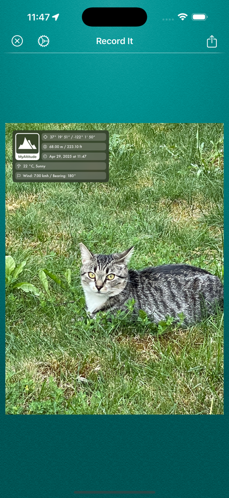
Screenshot of the Record It feature in the My Altitude app showing a photo watermarked with elevation and GPS coordinates.
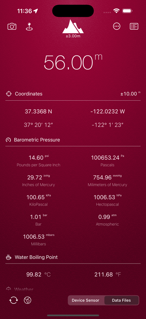
My Altitude app dashboard displaying current elevation, GPS coordinates, barometric pressure, and water boiling point.
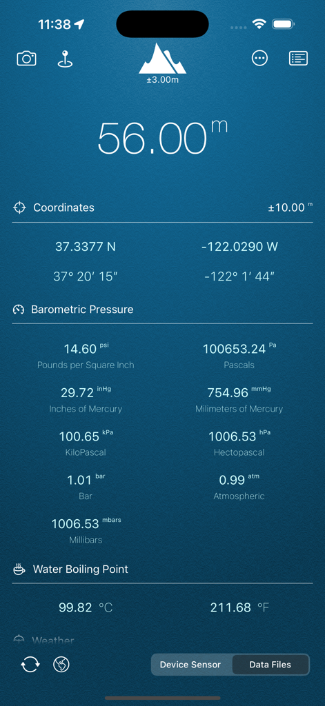
Interface of the My Altitude app displaying elevation, GPS coordinates, and barometric pressure metrics
Description
Download
More Like This
Apps with similar features and user experience

IQAir AirVisual | Air Quality
IQAir AG

CalTopo: Backcountry Mapping
CalTopo LLC

Mountain-Forecast.com
Meteo365 Ltd.

My Tide Times - Tables & Chart
JRustonApps B.V.

UV Index Widget - Worldwide
Bjorn Jenssen

My Aurora Forecast Pro
JRustonApps B.V.

Aviation weather - METAR & TAF
Hermann Hoelter

RiverApp - River levels
Florian Bessiere

Dronecast: UAV & Drone Weather
Pinverse LTD
This page is not an official page of the app or its developer, but an independent editorial publication created for informational and commentary purposes. Unless expressly stated otherwise, neither the app nor its developer is affiliated with, endorsed by, sponsored by, authorized by, or otherwise officially connected with MWM, Apple, Google Play, the app publisher, or the app's developer, and nothing on this page implies that the app was developed using MWM's services. Any trademarks, logos, screenshots, and other content remain the property of their respective owners.