This page is not an official page of the app or its developer, but an independent editorial publication created for informational and commentary purposes. Unless expressly stated otherwise, neither the app nor its developer is affiliated with, endorsed by, sponsored by, authorized by, or otherwise officially connected with MWM, Apple, Google Play, the app publisher, or the app's developer, and nothing on this page implies that the app was developed using MWM's services. Any trademarks, logos, screenshots, and other content remain the property of their respective owners.

CalTopo: Backcountry Mapping
Trusted by SAR teams and mountain guides to analyze complex terrain, monitor real-time conditions, and navigate off-grid with high-resolution data and seamless offline synchronization.
Downloads
514K+User Rating
Total Ratings
6K+Publisher
Category
NavigationLocales
1Latest Version
1.24.2Size
159.8 MBFirst Released
Oct 24, 2019Master the Backcountry with Professional Precision
From high-stakes Search and Rescue missions to technical ski tours, CalTopo provides the advanced mapping tools and offline data you need to navigate the most complex terrain safely.
Advanced Terrain Analysis
Identify avalanche-prone slopes and plan for solar intensity with high-resolution slope angle shading and sun exposure overlays.
Seamless Desktop-to-Field Sync
Meticulously plan complex routes on your computer and access them instantly on your mobile device, fully optimized for offline navigation.
Frequently Asked Questions
Everything you need to know about CalTopo: Backcountry Mapping
What is the CalTopo app?
The CalTopo app is a backcountry mapping tool for iOS, trusted by professionals, that allows users to plan, navigate, and track off-grid pursuits with offline capabilities and detailed map layers.
Does the CalTopo app work offline?
Yes, the CalTopo app works offline. It is satellite ready, allowing users to download maps and layers for offline use and to track their location using GPS without an internet connection.
Can I share maps with others using CalTopo?
Yes, the CalTopo app allows users to share maps with teams or travel partners for collaborative planning and real-time progress monitoring through live tracking.
What map layers does the CalTopo app offer?
The CalTopo app offers map layers including MapBuilder Topo, Global Imagery, Slope Angle Shading, Forest Service Maps, Parcel data, Weather Forecasting, and Fire History/Activity, among many others.
Does the CalTopo app integrate with CalTopo.com?
Yes, the CalTopo app provides seamless integration with CalTopo online. All changes made in the app automatically sync across all devices, ensuring up-to-date maps.
Can I record my route in the CalTopo app?
Yes, the CalTopo app enables users to track and record their routes. This feature provides data such as distance, elevation, and time for comprehensive outing documentation.
Does the CalTopo app support 3D mapping?
Yes, the CalTopo app supports 3D mapping. This feature allows users to gain a new perspective and visualize their routes within a three-dimensional terrain representation.
Can I add photos to waypoints in CalTopo?
Yes, the CalTopo app allows users to plan and document with photo waypoints. This feature enables attaching photos to specific locations on the map for enhanced documentation.
The following screenshots and description are sourced directly from the app's official store listing and are the property of the app developer.
App Store
Screenshots

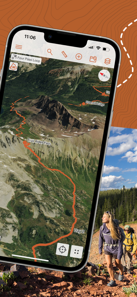
CalTopo app screen displaying its professional backcountry mapping and planning capabilities.
CalTopo app displaying a 3D terrain map with a marked hiking route and hikers in the background
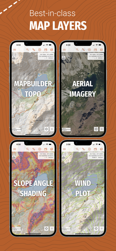
A showcase of CalTopo map layers including topo aerial imagery slope angle shading and wind plots on mobile devices
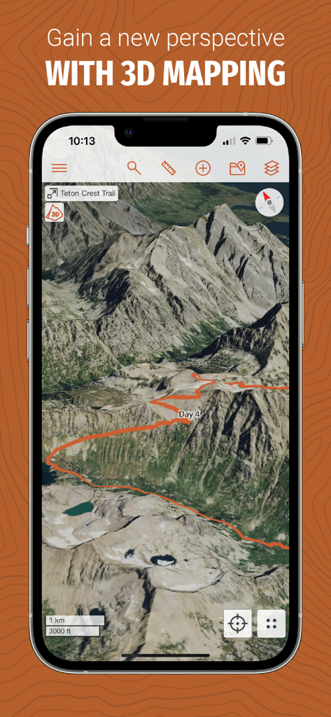
A 3D topographic map of a mountain range on the CalTopo app showing a planned backcountry trail.
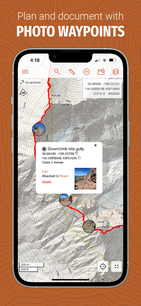
CalTopo app screenshot showing a topographic map with photo waypoints and route documentation
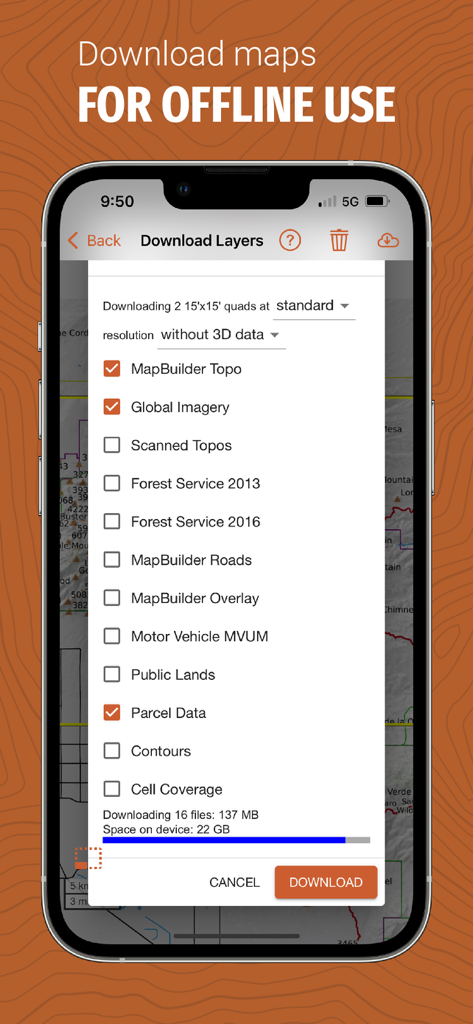
CalTopo app screen showing options to download map layers like topo imagery and parcel data for offline use.
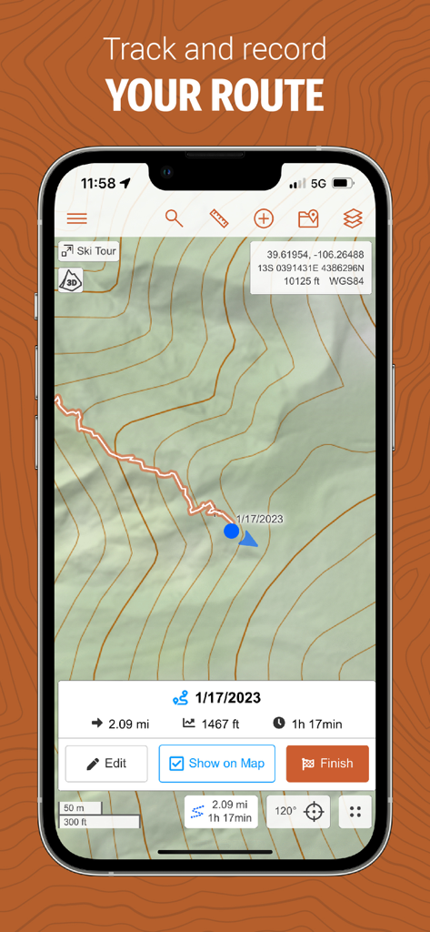
CalTopo app interface displaying a topographic map with a tracked ski tour route and trip statistics
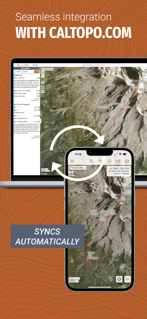
CalTopo mapping app and desktop website automatic synchronization interface
Description
Download
More Like This
Apps with similar features and user experience

IQAir AirVisual | Air Quality
IQAir AG

My Altitude
Dayana Networks Ltd

Mountain-Forecast.com
Meteo365 Ltd.

My Tide Times - Tables & Chart
JRustonApps B.V.

UV Index Widget - Worldwide
Bjorn Jenssen

My Aurora Forecast Pro
JRustonApps B.V.

Aviation weather - METAR & TAF
Hermann Hoelter

RiverApp - River levels
Florian Bessiere

Dronecast: UAV & Drone Weather
Pinverse LTD
This page is not an official page of the app or its developer, but an independent editorial publication created for informational and commentary purposes. Unless expressly stated otherwise, neither the app nor its developer is affiliated with, endorsed by, sponsored by, authorized by, or otherwise officially connected with MWM, Apple, Google Play, the app publisher, or the app's developer, and nothing on this page implies that the app was developed using MWM's services. Any trademarks, logos, screenshots, and other content remain the property of their respective owners.