This page is not an official page of the app or its developer, but an independent editorial publication created for informational and commentary purposes. Unless expressly stated otherwise, neither the app nor its developer is affiliated with, endorsed by, sponsored by, authorized by, or otherwise officially connected with MWM, Apple, Google Play, the app publisher, or the app's developer, and nothing on this page implies that the app was developed using MWM's services. Any trademarks, logos, screenshots, and other content remain the property of their respective owners.

TerraCam: GPS Satellite
No more guessing games. This app puts the world in your pocket, pinpointing every shot, every step, every view.
Downloads
1M+User Rating
Total Ratings
2.0KPublisher
Category
TravelLocales
17Latest Version
1.1.0Size
102.1 MBFirst Released
Sep 16, 2025An analytical overview of key features for avid travelers, photographers, and outdoor enthusiasts.
TerraCam: GPS Satellite - Core Functionality Review
GPS Photo Tagging
The app provides the capability to embed precise location, date, and time information directly into captured photographs, enhancing documentation for travelers and adventurers.
Interactive 3D Globe
This tool features an interactive 3D map interface, enabling users to explore global terrain and plan routes with a dynamic and immersive visual experience.
Integrated Digital Compass
It allows users to obtain accurate directional readings, which is essential for navigation and orientation during outdoor activities and travel.
Global Point of Interest Discovery
The app provides a curated list of famous landmarks and attractions globally, assisting users in discovering points of interest for their travel itineraries.
Panoramic Location Viewer
This tool features panoramic image viewing, offering users immersive, wide-angle perspectives of locations for enhanced exploration.
Worldwide Live Camera Feeds
It allows users to access live feeds from public cameras worldwide, providing real-time visual insights into various locations and conditions.
Real-Time Traffic Monitoring
The app provides real-time traffic condition updates on an interactive map, helping users plan routes and avoid congestion efficiently.
Local Air Quality Index
This tool features instant access to local air quality data, enabling users to make informed decisions about outdoor activities and health precautions.
Frequently Asked Questions
Everything you need to know about TerraCam: GPS Satellite
What is TerraCam: GPS Satellite?
TerraCam: GPS Satellite is an application that combines location tagging with map and travel tools. It allows users to capture photos with GPS details, explore interactive maps, check traffic, and access navigation features.
What are the main features of TerraCam: GPS Satellite?
TerraCam: GPS Satellite offers GPS Camera, Live Cameras, 360 View, Earth 3D Map, Traffic Map, Famous Places, Compass, Air Quality, and World Clock. These provide comprehensive navigation and exploration tools.
Can TerraCam: GPS Satellite capture photos with location data?
Yes, TerraCam: GPS Satellite includes a GPS Camera feature. It captures photos embedded with location, date, and time details, ensuring your memories are accurately geotagged.
Does TerraCam: GPS Satellite offer a 3D view of Earth?
Yes, TerraCam: GPS Satellite features an Earth 3D Map. This allows users to navigate the globe with interactive three-dimensional views, enhancing exploration.
How can I check traffic conditions using TerraCam: GPS Satellite?
TerraCam: GPS Satellite provides a Traffic Map feature to keep you updated. It displays real-time traffic conditions, assisting you with navigation and travel planning.
Does TerraCam: GPS Satellite include a compass?
Yes, TerraCam: GPS Satellite integrates a Compass feature. This tool provides accurate directions, making it easy to orient yourself during travel or exploration.
Where can I find the Privacy Policy for TerraCam: GPS Satellite?
The Privacy Policy for TerraCam: GPS Satellite is available at https://sites.google.com/view/terra-cam-gps/privacy-policy. This document outlines how the app handles user data.
Can TerraCam: GPS Satellite show live camera feeds?
Yes, TerraCam: GPS Satellite includes a Live Cameras feature. It allows users to view selected public cameras from various locations around the world.
What types of map views are available in TerraCam: GPS Satellite?
TerraCam: GPS Satellite offers various map views, including Default, Terrain, Satellite, and Night. Users can select their preferred map style for navigation and exploration.
The following screenshots and description are sourced directly from the app's official store listing and are the property of the app developer.
App Store
Screenshots

This tool presents a centralized interface, showcasing the interactive LIVE Earth Map and intuitive quick access buttons like 'Camera GPS' and 'Earth 3D'.
App Central Hub
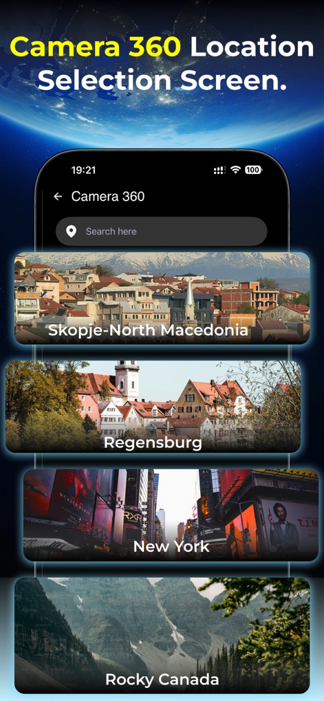
Users can effortlessly browse a curated list of global hotspots or utilize the integrated search bar to pinpoint specific locations for a panoramic 360 view.
Explore Destinations
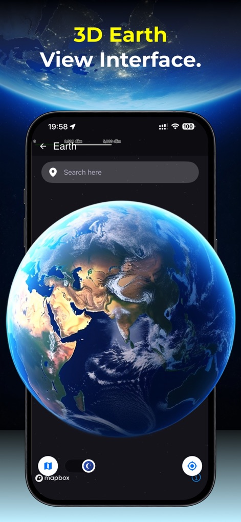
This view offers an immersive 3D globe for detailed exploration, complemented by intuitive navigation controls for zooming and perspective adjustments.
Interactive 3D Globe
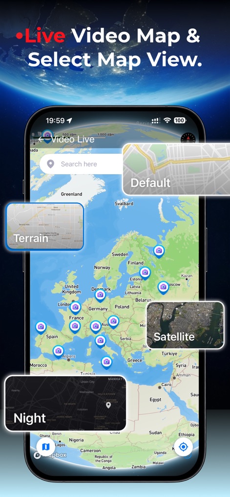
The app provides a comprehensive map featuring numerous live camera icons and a selection of diverse map overlays, including Terrain and Satellite views.
Versatile Map Modes
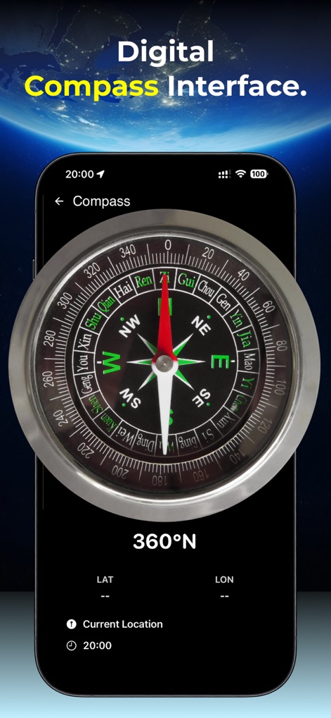
This feature displays a precise digital compass, providing users with real-time directional readings and current latitude and longitude coordinates.
Accurate Digital Compass
Description
Download
More Like This
Apps with similar features and user experience

Realtime Altimeter
Zhenlai Xia

Travel Camera & Compass
Ha Nguyen

compass-latitude and longitude
美霞 熊

Compass ×
DOUBLE U s.r.o.

GPS Altitude-海拔表
祥琦 孔

Compass: GPS & Altimeter
Shanghai BRC Internet Technology Co., Ltd.

Compass - GPS positioning
嘉 罗

Compass360X-GPS Speedometer
卫豪 吴

指南针-GPS经纬度海拔定位
Chongqing Xinzhi Space Technology Co., Ltd.
This page is not an official page of the app or its developer, but an independent editorial publication created for informational and commentary purposes. Unless expressly stated otherwise, neither the app nor its developer is affiliated with, endorsed by, sponsored by, authorized by, or otherwise officially connected with MWM, Apple, Google Play, the app publisher, or the app's developer, and nothing on this page implies that the app was developed using MWM's services. Any trademarks, logos, screenshots, and other content remain the property of their respective owners.