This page is not an official page of the app or its developer, but an independent editorial publication created for informational and commentary purposes. Unless expressly stated otherwise, neither the app nor its developer is affiliated with, endorsed by, sponsored by, authorized by, or otherwise officially connected with MWM, Apple, Google Play, the app publisher, or the app's developer, and nothing on this page implies that the app was developed using MWM's services. Any trademarks, logos, screenshots, and other content remain the property of their respective owners.

compass-latitude and longitude
Master your environment with high-accuracy GPS, altitude, and pressure data. The all-in-one toolkit for outdoor explorers and field professionals who demand absolute reliability.
Downloads
1M+User Rating
Total Ratings
18K+Publisher
Category
NavigationLocales
2Latest Version
1.3.3Size
24.7 MBFirst Released
Dec 3, 2021Professional Precision for Every Journey
Equip yourself with an all-in-one navigation suite designed for technical accuracy and outdoor reliability, from mountain peaks to professional job sites.
Hyper-Accurate Positioning
Get instant access to real-time latitude, longitude, and altitude data powered by advanced GPS and mobile sensor integration.
Professional Theodolite Camera
Capture site documentation with GPS coordinates, altitude, and timestamps automatically burned into every photo for effortless reporting.
Frequently Asked Questions
Everything you need to know about compass-latitude and longitude
Does the compass-latitude and longitude app measure GPS speed?
Yes, the Compass app provides a GPS speed measurement function. It displays real-time current driving speed and indicates signal strength and potential errors.
Can the Compass app record location data with photos?
Yes, the Compass app supports camera photography to record and manage latitude, longitude, and altitude data. This feature allows users to associate location information with images.
What are the benefits of a professional subscription to the Compass app?
A professional subscription to the Compass app provides all accurate geographic data, unlimited GPS speed measurements, unlimited camera recording, an ad-free experience, and prioritized feature updates.
How do I cancel my subscription for the compass-latitude and longitude app?
To cancel your subscription for the compass-latitude and longitude app, navigate to your iTunes settings at least 24 hours before the end of your free trial period or current subscription cycle.
Where can I find the privacy policy for the Compass app?
The privacy policy for the Compass app is available at the provided URL: https://sites.google.com/view/theodolite-privacy-policy. It outlines how user data is handled.
Does the Compass app display detailed altitude and atmospheric data?
Yes, the Compass app displays detailed altitude data. It also provides air data, including oxygen content and ratio, magnetic field induction, and barometric pressure measurements.
What data does the Compass app provide?
The Compass app provides real-time weather, longitude, latitude, altitude, GPS speed, pressure, and wind direction data. It also displays detailed air data, magnetic field information, and barometric pressure.
The following screenshots and description are sourced directly from the app's official store listing and are the property of the app developer.
App Store
Screenshots
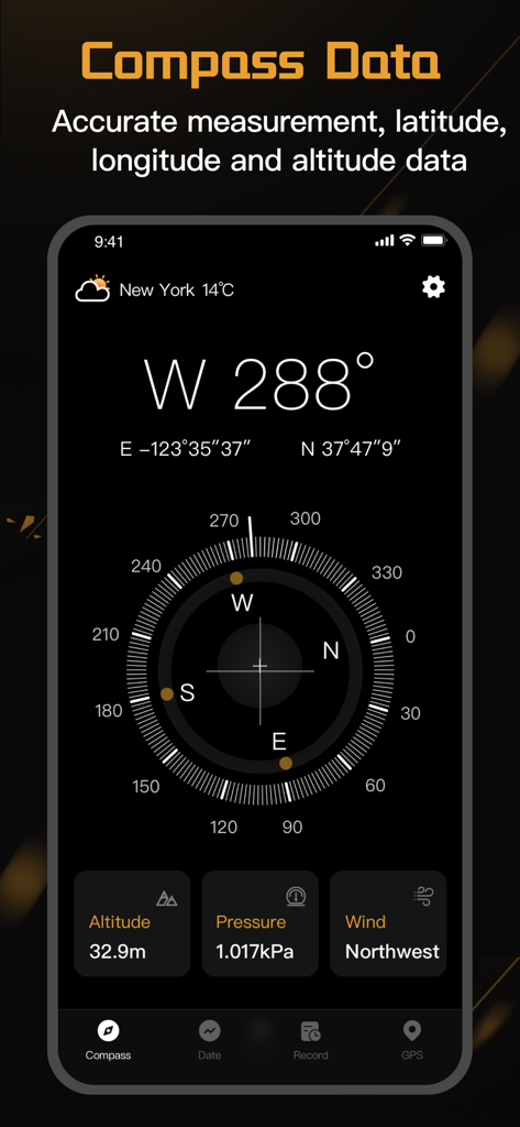
Digital compass interface displaying latitude longitude altitude and barometric pressure
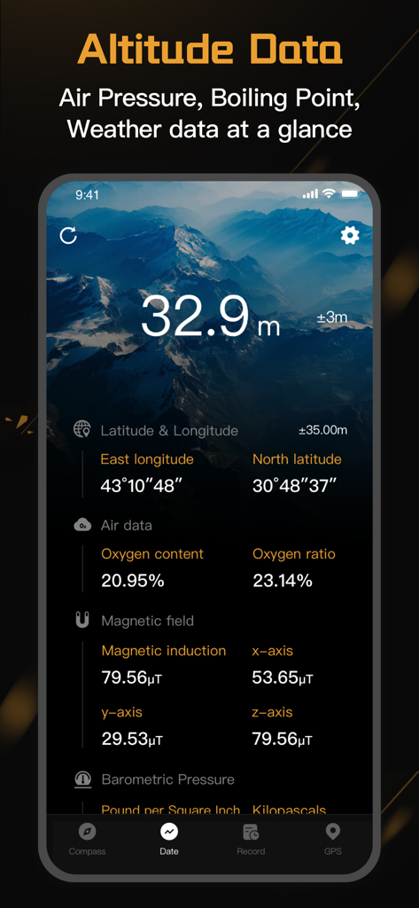
A professional navigation app interface showing real-time altitude, GPS coordinates, and atmospheric data
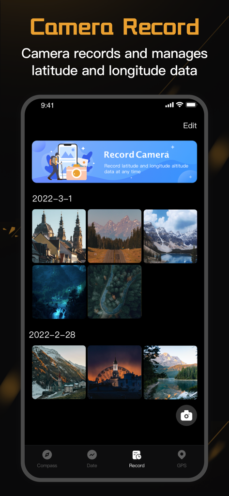
Interface showing a photo gallery within the compass app with recorded latitude and longitude data for each image
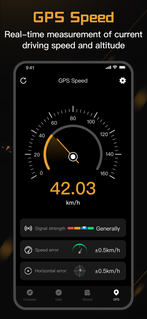
Digital speedometer interface showing real time driving speed measurement in kmh with signal strength and accuracy metrics
Description
Download
More Like This
Apps with similar features and user experience

Realtime Altimeter
Zhenlai Xia

Travel Camera & Compass
Ha Nguyen

Compass ×
DOUBLE U s.r.o.

GPS Altitude-海拔表
祥琦 孔

Compass: GPS & Altimeter
Shanghai BRC Internet Technology Co., Ltd.

Compass - GPS positioning
嘉 罗

Compass360X-GPS Speedometer
卫豪 吴

指南针-GPS经纬度海拔定位
Chongqing Xinzhi Space Technology Co., Ltd.

Travel Altimeter & Elevation
BranchenKing Ltd.
This page is not an official page of the app or its developer, but an independent editorial publication created for informational and commentary purposes. Unless expressly stated otherwise, neither the app nor its developer is affiliated with, endorsed by, sponsored by, authorized by, or otherwise officially connected with MWM, Apple, Google Play, the app publisher, or the app's developer, and nothing on this page implies that the app was developed using MWM's services. Any trademarks, logos, screenshots, and other content remain the property of their respective owners.