このページはアプリまたはその開発者の公式ページではなく、情報提供および論評を目的として作成された独立した編集出版物です。明示的に別段の記載がない限り、アプリおよびその開発者は、MWM、Apple、Google Play、アプリのパブリッシャー、またはアプリの開発者と提携、承認、後援、認可、またはその他の公式的な関係はなく、このページのいかなる内容も、アプリがMWMのサービスを使用して開発されたことを意味するものではありません。すべての商標、ロゴ、スクリーンショット、その他のコンテンツはそれぞれの所有者の財産です。

3D实况卫星导航-指南针北斗智能语音导航
退屈なルート案内は過去のものだ。このアプリは、地図を「読む」のではなく「体験する」力を与える。
ダウンロード
750k+ユーザー評価
評価数
3.9K開発元
カテゴリ
Navigation対応言語
3最新バージョン
1.0.7サイズ
140.5 MBリリース日
2025年8月28日テックアナリストによる多機能ナビゲーションツールの詳細評価
「3D实况卫星导航」アプリの主要機能分析
全国釣りスポット網羅
ユーザーは全国の高品質な釣りスポット(野池、貯水池、河川、海釣りなど)の情報を確認し、近くのスポットを迅速に検索し、釣り場の種類や魚種情報を確認することで、釣果豊かな釣行を計画することが可能です。
リアルタイム3D音声ナビゲーション
このアプリは、道路、陸橋、建物のモデルを完全に3Dで再現し、複雑な道路状況を一目で明確に表示するため、ユーザーは道に迷うことなく目的地に到達できます。リアルタイムの交通情報に基づいて最適なルートを計画し、正確な音声案内を提供します。
全国観光スポット詳細情報
本ツールは、人気の観光スポットからニッチな穴場まで、全国の観光スポットの分布図をワンクリックで照会できます。これにより、ユーザーは事前に情報を把握し、より計画的で充実した旅行体験を楽しむことができます。
高精細衛星地図表示
ユーザーは高精細な衛星地図にシームレスに切り替えることができ、街路、建物、山、川を鮮明に表示します。標準地図、衛星地図、交通ルート地図など、様々なレイヤーを自由に切り替えることができ、多様なシナリオでの閲覧ニーズに対応します。
よくある質問
について知っておくべきこと 3D实况卫星导航-指南针北斗智能语音导航
What is the primary function of 3D Live Satellite Navigation?
3D Live Satellite Navigation is an all-round travel explorer providing precise navigation, high-definition satellite views, fishing and travel exploration, and practical map tools. It integrates various features for a top-quality map experience.
Does 3D Live Satellite Navigation provide live 3D voice navigation?
Yes, 3D Live Satellite Navigation provides live 3D voice navigation. It features true 3D road conditions, real-time traffic updates, optimal route planning, and precise voice announcements for an immersive driving experience.
Can I view high-definition satellite maps with 3D Live Satellite Navigation?
Yes, 3D Live Satellite Navigation allows viewing high-definition satellite maps. Users can switch between standard, satellite, and traffic route map layers to see streets, buildings, mountains, and rivers clearly.
Does 3D Live Satellite Navigation list fishing spots?
Yes, 3D Live Satellite Navigation lists comprehensive fishing spots nationwide. It includes information on wild ponds, reservoirs, rivers, and sea fishing, allowing quick queries for nearby locations and fish species.
Does 3D Live Satellite Navigation feature information on scenic spots?
Yes, 3D Live Satellite Navigation includes a comprehensive list of national scenic spots. Users can query distribution maps of popular and niche attractions to plan their journeys effectively and learn about destination details.
What practical map tools are included in 3D Live Satellite Navigation?
3D Live Satellite Navigation includes a practical map toolbox. Features comprise real-time altitude measurement, a compass for direction identification, and a latitude and longitude camera for recording geographical coordinates in photos.
How much does an annual membership for 3D Live Satellite Navigation cost?
An annual membership subscription for 3D Live Satellite Navigation costs 198 yuan per year. This price is subject to automatic renewal through your iTunes account unless cancelled by the user.
What is the weekly membership price for 3D Live Satellite Navigation?
The weekly membership subscription price for 3D Live Satellite Navigation is 48 yuan per week. This service renews automatically via the user's iTunes account unless cancelled before the cycle ends.
How do I cancel my 3D Live Satellite Navigation subscription?
To cancel a 3D Live Satellite Navigation subscription, navigate to 'Settings' then 'Apple Account,' and select 'Subscriptions.' Find the corresponding subscription item and choose to cancel it there.
Does 3D Live Satellite Navigation offer real-time traffic information?
Yes, 3D Live Satellite Navigation offers real-time traffic information. The app updates this data to intelligently plan the optimal route and provide precise voice announcements for safe travel.
Can 3D Live Satellite Navigation measure altitude?
Yes, 3D Live Satellite Navigation can measure altitude. It provides real-time current altitude checks, useful for activities like climbing or hiking, as part of its practical map toolbox.
以下のスクリーンショットと説明は、アプリの公式ストアリスティングから直接取得されたものであり、アプリ開発者の所有物です。
アプリストア
スクリーンショット
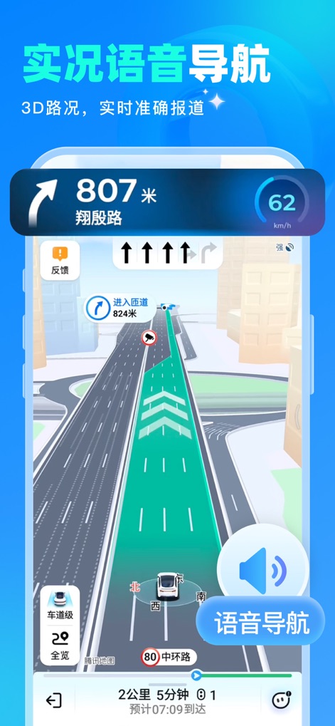
リアルタイムの交通情報と3D立体道路表示で、ユーザーは複雑な道路状況も一目で把握し、音声ガイダンスアイコンにより安全なルート案内を受けられます。
実況3Dナビ
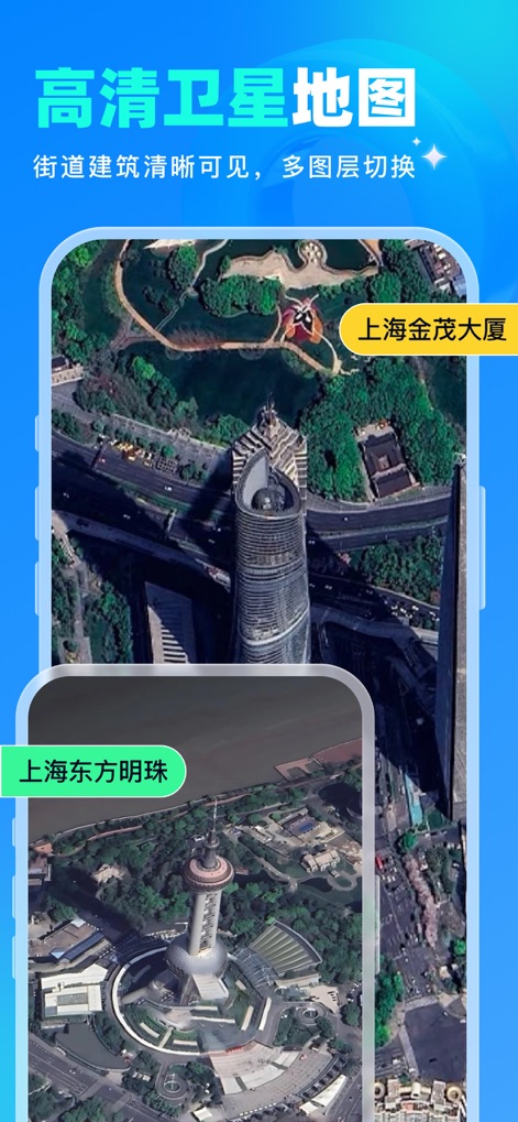
高精細衛星画像で世界を俯瞰し、ユーザーは上海金茂大廈などの具体的な建物識別表示によって、都市の構造や自然の驚異を詳細に探索できます。
高精細衛星地図
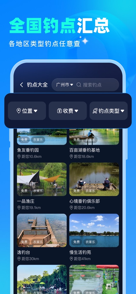
全国の釣りスポット一覧から、ユーザーは自身の好みに合わせて場所、料金、種類でフィルタリングオプションを活用し、最適な釣り場を簡単に見つけることができます。
全国釣り場検索

全国の観光スポット分布地図と人気スポットの画像表示により、ユーザーは手軽に目的地を検索し、旅行計画をより豊かで効率的に立てることができます。
全国観光地ガイド
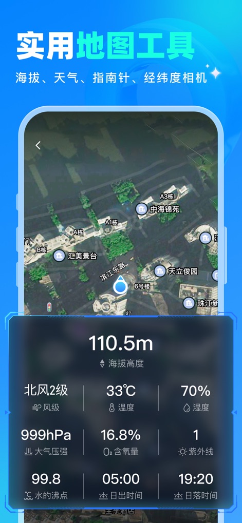
リアルタイムの標高表示と詳細な天気情報を通じて、ユーザーは登山やハイキング中に現在の状況を正確に把握し、アウトドア活動をより安全に楽しむことができます。
役立つ地図ツール
説明
Download
類似アプリ
似た機能とユーザー体験を持つアプリ

AllTrails: Hike, Bike & Run
AllTrails, Inc.

Pedometer++
Cross Forward Consulting, LLC

Organic Maps: Offline Map
Organic Maps OU

Gaia GPS: Mobile Trail Maps
Trailbehind, INC.

Offline hiking maps: Mapy.com
Seznam.cz a.s.

Hiking Map Poland
Mapa Turystyczna sp. z o.o.

MapOut
Valnova GmbH

FarOut: Offline GPS Trail Maps
Atlas Guides DE, Inc.

Norgeskart
Norgeskart AS
このページはアプリまたはその開発者の公式ページではなく、情報提供および論評を目的として作成された独立した編集出版物です。明示的に別段の記載がない限り、アプリおよびその開発者は、MWM、Apple、Google Play、アプリのパブリッシャー、またはアプリの開発者と提携、承認、後援、認可、またはその他の公式的な関係はなく、このページのいかなる内容も、アプリがMWMのサービスを使用して開発されたことを意味するものではありません。すべての商標、ロゴ、スクリーンショット、その他のコンテンツはそれぞれの所有者の財産です。