このページはアプリまたはその開発者の公式ページではなく、情報提供および論評を目的として作成された独立した編集出版物です。明示的に別段の記載がない限り、アプリおよびその開発者は、MWM、Apple、Google Play、アプリのパブリッシャー、またはアプリの開発者と提携、承認、後援、認可、またはその他の公式的な関係はなく、このページのいかなる内容も、アプリがMWMのサービスを使用して開発されたことを意味するものではありません。すべての商標、ロゴ、スクリーンショット、その他のコンテンツはそれぞれの所有者の財産です。

Gaia GPS: Mobile Trail Maps
紙の地図を捨てろ。このアプリが持つのは、失われた世界を指し示す力だ。
ダウンロード
2.5M+ユーザー評価
評価数
37.9K開発元
カテゴリ
Navigation対応言語
17最新バージョン
2026.2サイズ
120.1 MBリリース日
2017年5月22日テックアナリストによる主要機能の評価とアウトドア愛好家への影響
Gaia GPS: モバイルトレイルマップの機能分析
オフラインマップとナビゲーション
携帯電話サービスが届かない遠隔地でも、詳細な地形図とGPSナビゲーションを利用して、ルート計画、追跡、および安全な探査を可能にします。
豊富な地形図と専門地図コレクション
Gaia Topo、National Geographic Trails Illustrated、プライベートランドマップなど、300以上の専門地図を利用でき、あらゆるアウトドア活動に最適な視覚情報と詳細な地形データを提供します。
包括的なルート計画とアクティビティ追跡
ユーザーは独自のルートを作成し、移動距離、標高、高度をリアルタイムで追跡することで、ハイキング、バックパッキング、オフロードなどの冒険の準備と進行状況のモニタリングを効率的に行えます。
キャンプ場と公共地の簡単な発見
国立公園や森林内のキャンプ場、公共の土地を容易に特定し、GPS座標を利用して目的地まで効率的に移動できるため、安心してアウトドア活動を計画できます。
リアルタイム天気予報と安全対策機能
最新の天気予報、地形情報、およびスキーリゾートの状況を提供し、ユーザーが悪天候に備え、安全なアウトドア活動を計画するのに役立ちます。
多様なアウトドア活動への包括的対応
ハイキング、バックパッキングに加えて、オフロード、オーバーランディング、スキー、スノーシューなど、幅広い種類のアウトドア活動に対応する専門的なツールと情報を提供します。
Apple CarPlayとのシームレスな統合
車載ディスプレイで地図、ルート、ウェイポイントを表示できるため、特にオフロードやオーバーランディングの際に、安全で便利なナビゲーション体験を提供します。
外部サービス連携とプレミアムコンテンツアクセス
Trailforks GPSバイクアプリへのアクセスや、Outside Networkのプレミアムコンテンツ(記事、ビデオ、オンラインコースなど)を利用でき、アウトドア体験を多角的に豊かにします。
よくある質問
について知っておくべきこと Gaia GPS: Mobile Trail Maps
What is Gaia GPS?
Gaia GPS is a mobile application providing a comprehensive collection of hiking trails and camping sites. It offers GPS navigation, topographic maps, weather updates, and route planning for various outdoor activities like backpacking, off-roading, and skiing.
Does Gaia GPS offer offline map capabilities?
Yes, Gaia GPS offers offline maps. Users can download maps for offline use to navigate without cell service. The premium version allows downloading over 300 maps anytime.
Can users create and record their own routes with Gaia GPS?
Yes, users can create routes using snap-to-trail mode and custom waypoints with Gaia GPS. The app also records tracks, providing detailed statistics on speed, distance, elevation, and duration.
What types of outdoor activities does Gaia GPS support?
Gaia GPS supports diverse outdoor activities including hiking, backpacking, camping, RV travel, 4x4 off-roading, overlanding, skiing, and snowboarding. It provides specialized maps and features for each.
Does Gaia GPS integrate with Apple CarPlay?
Yes, Gaia GPS displays maps, routes, and waypoints directly on Apple CarPlay. This feature enhances navigation for offroad trails and other adventures.
What premium features are included with Gaia GPS Premium with Outside+?
Gaia GPS Premium with Outside+ includes access to over 300 maps, offline map downloads, weather and safety features, the Trailforks GPS biking app, expert-led courses, premium films, and unlimited digital access to Outside Network brands.
How can users manage their Gaia GPS subscription?
Users manage their Gaia GPS subscription by turning off auto-renewal through their Apple App Store account settings. Subscriptions automatically renew unless disabled at least 24 hours before the current period ends.
Does Gaia GPS provide cell coverage maps?
Yes, Gaia GPS offers cell coverage maps as premium layers for various carriers. These maps help users identify areas with or without cell service.
Can Gaia GPS show air quality or weather forecasts?
Yes, Gaia GPS displays air quality and weather forecasts. Map overlays include Air Quality (Current), Smoke Forecast (Today), Snow Forecast (24-Hour), and Precip Forecast (48-Hour).
What map layers are available in Gaia GPS?
Gaia GPS offers various map layers and packs including Gaia Topo, Overlanding, Satellite, Fresh Sat, NatGeo Trails, Public Land (US), Slope Angle, Avalanche Forecast, and Cell Coverage maps.
以下のスクリーンショットと説明は、アプリの公式ストアリスティングから直接取得されたものであり、アプリ開発者の所有物です。
アプリストア
スクリーンショット

ユーザーは正確な現在地を地図上で把握し、広大な自然の景観の中で自信を持ってルートナビゲーションを行うことができます。
冒険を自信を持って

携帯電波圏外でも、ユーザーは詳細なオフラインマップで現在地を確認し、移動距離や経過時間などの主要なアクティビティ統計を把握できます。
オフラインでも安心

ユーザーは活動フィードを通じてインスピレーションを刺激する記事を発見し、インタラクティブな地図表示で新しいアウトドアアクティビティを見つけることができます。
新しい冒険を発見

ユーザーは地図上で直感的なルート描画ツールを使用して独自のコースを作成し、下部の標高プロファイルで道のりの起伏を詳細に確認できます。
ルートを自由に作成
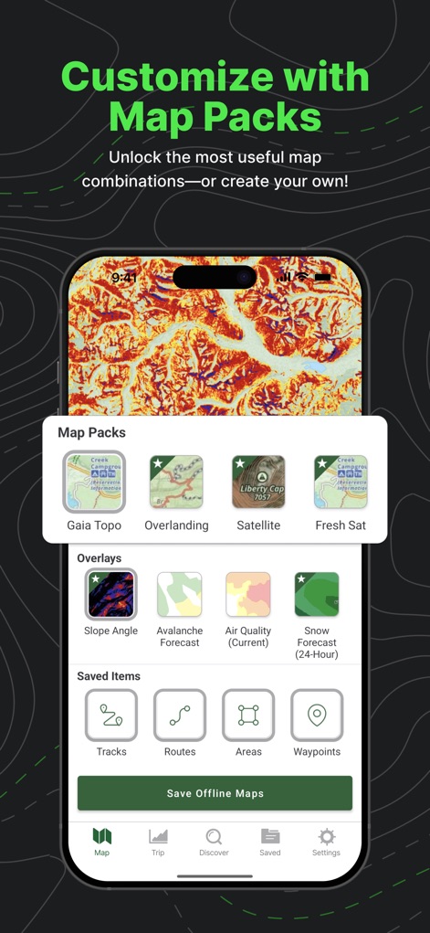
ユーザーは「Map Packs」から多様な地図の種類を選び、さらに「Overlays」機能で斜度や雪崩予報などの詳細情報を追加して表示をカスタマイズできます。
地図パックをカスタマイズ

ユーザーは地形図や国立公園の地図など、様々な地図レイヤーを選択して重ね合わせ、降水予報を組み合わせてあらゆる冒険に備えることができます。
あらゆる冒険に対応

ユーザーは速度プロファイルや標高プロファイルを含む詳細な統計データを記録し、自身のパフォーマンスを距離や平均速度といった指標で振り返ることができます。
詳細な活動記録

ユーザーはキャリア別の電波カバレッジマップを利用して、計画エリアの通信状況を事前に確認し、接続可能な地域と圏外の地域を明確に把握できます。
電波状況を把握
説明
Download
類似アプリ
似た機能とユーザー体験を持つアプリ

AllTrails: Hike, Bike & Run
AllTrails, Inc.

Pedometer++
Cross Forward Consulting, LLC

Organic Maps: Offline Map
Organic Maps OU

Offline hiking maps: Mapy.com
Seznam.cz a.s.

Hiking Map Poland
Mapa Turystyczna sp. z o.o.

MapOut
Valnova GmbH

FarOut: Offline GPS Trail Maps
Atlas Guides DE, Inc.

Norgeskart
Norgeskart AS

GPX viewer - map
Lucas den Otter
このページはアプリまたはその開発者の公式ページではなく、情報提供および論評を目的として作成された独立した編集出版物です。明示的に別段の記載がない限り、アプリおよびその開発者は、MWM、Apple、Google Play、アプリのパブリッシャー、またはアプリの開発者と提携、承認、後援、認可、またはその他の公式的な関係はなく、このページのいかなる内容も、アプリがMWMのサービスを使用して開発されたことを意味するものではありません。すべての商標、ロゴ、スクリーンショット、その他のコンテンツはそれぞれの所有者の財産です。