このページはアプリまたはその開発者の公式ページではなく、情報提供および論評を目的として作成された独立した編集出版物です。明示的に別段の記載がない限り、アプリおよびその開発者は、MWM、Apple、Google Play、アプリのパブリッシャー、またはアプリの開発者と提携、承認、後援、認可、またはその他の公式的な関係はなく、このページのいかなる内容も、アプリがMWMのサービスを使用して開発されたことを意味するものではありません。すべての商標、ロゴ、スクリーンショット、その他のコンテンツはそれぞれの所有者の財産です。

Organic Maps・Maps & Navigation
インターネットも個人情報も不要。このアプリは、ユーザーをデジタル世界の束縛から解放し、真の自由な探索を可能にする。
ダウンロード
1M+ユーザー評価
評価数
15.2K開発元
カテゴリ
Navigation対応言語
48最新バージョン
2026.04.07サイズ
139.6 MBリリース日
2021年6月12日テックアナリストによる主要機能の評価と解説
Organic Maps・Maps & Navigation アプリケーション分析
完全オフライン運用
このアプリは、検索やナビゲーションを含むすべての機能をインターネット接続なしで提供し、データ料金の節約とバッテリー寿命の延長を可能にします。
プライバシー第一の設計
本ツールはユーザーデータや識別子を一切収集せず、広告や邪魔な通知がないクリーンでプライベートな地図体験を提供します。
詳細かつ最新の地図データ
ユーザーはOpenStreetMapに基づいた非常に詳細な地図を利用でき、建物ラベル、ベンチ、ハイキングパスなどが含まれ、2週間ごとに更新されます。
専用の屋外アクティビティマップレイヤー
本ツールは、OpenStreetMapから提供される人気のあるハイキングおよびサイクリングルートを表示するための特別な地図レイヤーを備えており、さまざまなアクティビティに合わせたルート探しを支援します。
高機能GPSナビゲーション
このアプリは音声案内付きのターンバイターンナビゲーションを提供し、ウォーキング、ハイキング、サイクリング、ドライブなど多様な移動手段に対応し、CarPlayもサポートしています。
広範な場所探索とPOI情報
ユーザーは、住所、名前、またはカテゴリで場所を検索し、何百万ものPOI(興味のある場所)を発見でき、営業時間やウィキペディア記事などの詳細情報もオフラインで閲覧できます。
高速な処理性能
このアプリは、ズーム、検索、ルート計算において顕著な高速性を提供し、スムーズなユーザー体験を実現します。
トラック記録と経路管理
この機能により、ユーザーは自身のルートやお気に入りの場所を記録、インポート、エクスポート、共有することができ、KML、KMZ、GPX、GeoJSON形式をサポートしています。
よくある質問
について知っておくべきこと Organic Maps・Maps & Navigation
Does Organic Maps work offline?
Yes, Organic Maps functions 100% offline, including search and navigation. Users can explore maps and get directions without an internet connection, saving mobile data and battery life.
Is Organic Maps free to use?
Yes, Organic Maps is 100% free. It is also ad-free and does not require in-app purchases for full functionality, providing a completely free mapping experience without hidden costs.
Does Organic Maps collect user data?
No, Organic Maps is privacy-first and does not collect any user data or identifiers. This ensures no data leaks, ads, or noisy notifications, providing a clean private map experience.
What types of navigation does Organic Maps offer?
Organic Maps provides voice-guided, turn-by-turn navigation for walking, hiking, cycling, and driving routes. It supports routes between cities, countries, multiple waypoints, and CarPlay.
How often are maps updated in Organic Maps?
Maps in Organic Maps are updated biweekly. The app uses OpenStreetMap data, which is refreshed every two weeks, ensuring the maps reflect current real-world conditions and details accurately.
What data source does Organic Maps use for its maps?
Organic Maps uses OpenStreetMap, a wiki-style world map built and maintained by millions of volunteers. This community effort results in highly detailed and often more accurate maps.
Can users record and import custom routes in Organic Maps?
Yes, Organic Maps includes a Track Recorder feature. Users can record, import, export, and share their routes and favorite places, supporting KML, KMZ, GPX, and GeoJSON formats.
How can I find points of interest (POIs) with Organic Maps?
Organic Maps allows users to search by address, name, or category to discover millions of Points of Interest (POIs). It provides detailed information like opening hours and Wikipedia articles, all offline.
Does Organic Maps offer different map styles or layers?
Yes, Organic Maps offers various map styles tailored to activities, including Outdoors, Contour Lines, Hiking, Cycling, and Metro/Subway. Users can switch layers to view specific routes.
Does Organic Maps display advertisements?
No, Organic Maps is completely ad-free. It does not contain any advertisements or noisy notifications, ensuring a distraction-free and private mapping experience for all users.
Does Organic Maps support a dark mode?
Yes, Organic Maps supports a Dark Mode feature. Users can switch to a dark theme for comfortable viewing, which is particularly beneficial for use at night or in low-light conditions.
Can I sync my data in Organic Maps across devices?
Yes, Organic Maps provides iCloud Sync functionality. Users can easily back up and synchronize all their bookmarks and tracks across their Apple devices for seamless continuity.
以下のスクリーンショットと説明は、アプリの公式ストアリスティングから直接取得されたものであり、アプリ開発者の所有物です。
アプリストア
スクリーンショット
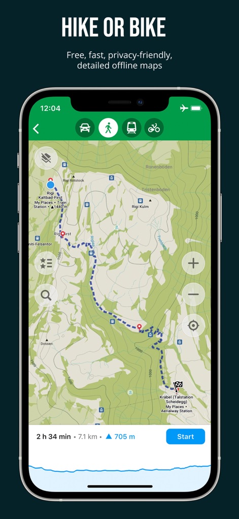
このアプリは、詳細な等高線を含む地形図と、ルートの所要時間、距離、獲得標高を表示する出発準備画面を提供し、アウトドアアクティビティの計画をサポートします。
アウトドア計画、完璧に
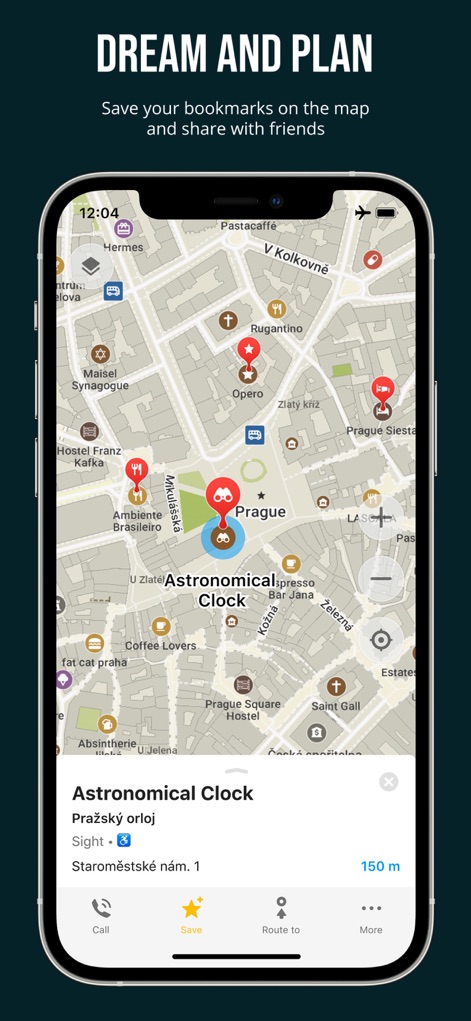
ユーザーは、ランドマークや関心地点を地図上にブックマークとして保存でき、選択した地点に関する詳細情報を表示するインタラクティブな情報シートで、場所の発見と旅行の計画を効率的に行えます。
旅の計画、保存
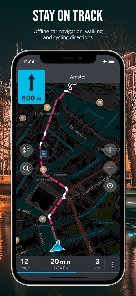
本アプリは、現在地から目的地までのルートをターンバイターン方式で視覚的に案内し、夜間や暗い環境でも快適に利用できるダークモードの地図表示を提供することで、ユーザーの移動をサポートします。
夜間も安心ナビ
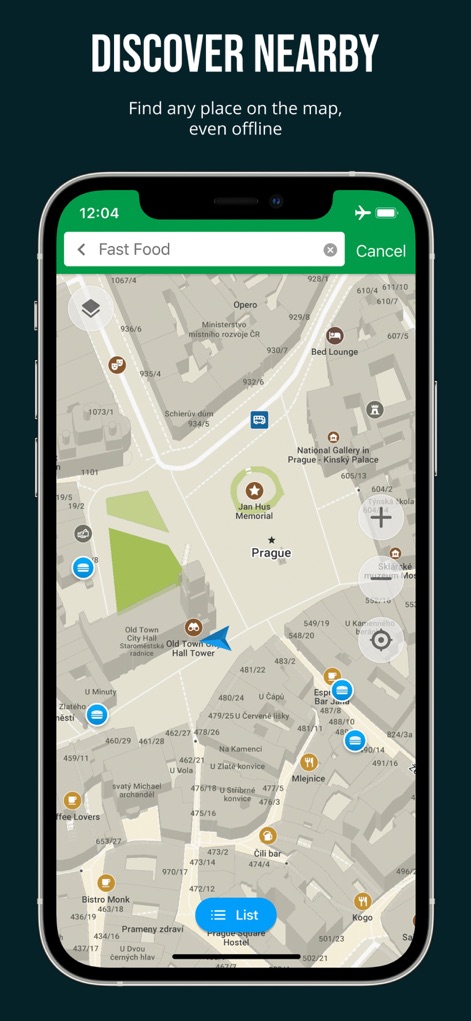
このツールは、インターネット接続がない環境でも利用できる検索バーを備え、ユーザーは「ファストフード」などのカテゴリで近隣の関心地点を検索し、地図上にリスト表示された結果から目的地を選ぶことができます。
オフラインで周辺検索
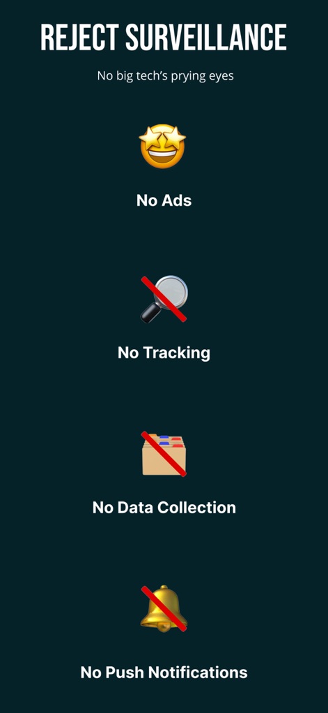
本アプリは、データ収集やユーザー追跡を一切行わないプライバシーポリシーを明示し、広告や不要なプッシュ通知がないクリーンなユーザー体験を提供することで、ユーザーの安心と集中を保証します。
プライバシー、最優先
説明
Download
類似アプリ
似た機能とユーザー体験を持つアプリ

AllTrails: Hike, Bike & Run
AllTrails, Inc.

Pedometer++
Cross Forward Consulting, LLC

Gaia GPS: Mobile Trail Maps
Trailbehind, INC.

Offline hiking maps: Mapy.com
Seznam.cz a.s.

Hiking Map Poland
Mapa Turystyczna sp. z o.o.

MapOut
Valnova GmbH

FarOut: Offline GPS Trail Maps
Atlas Guides DE, Inc.

Norgeskart
Norgeskart AS

GPX viewer - map
Lucas den Otter
このページはアプリまたはその開発者の公式ページではなく、情報提供および論評を目的として作成された独立した編集出版物です。明示的に別段の記載がない限り、アプリおよびその開発者は、MWM、Apple、Google Play、アプリのパブリッシャー、またはアプリの開発者と提携、承認、後援、認可、またはその他の公式的な関係はなく、このページのいかなる内容も、アプリがMWMのサービスを使用して開発されたことを意味するものではありません。すべての商標、ロゴ、スクリーンショット、その他のコンテンツはそれぞれの所有者の財産です。