このページはアプリまたはその開発者の公式ページではなく、情報提供および論評を目的として作成された独立した編集出版物です。明示的に別段の記載がない限り、アプリおよびその開発者は、MWM、Apple、Google Play、アプリのパブリッシャー、またはアプリの開発者と提携、承認、後援、認可、またはその他の公式的な関係はなく、このページのいかなる内容も、アプリがMWMのサービスを使用して開発されたことを意味するものではありません。すべての商標、ロゴ、スクリーンショット、その他のコンテンツはそれぞれの所有者の財産です。

bergfex: Hiking & Tracking
真剣なアウトドアアスリートのために、地形学的な精度、高度な安全ツール、シームレスなデータ同期で地形をマスターしましょう。ロッキー山脈からアルプスまで、オフグリッドでも自信を持ってナビゲートできます。
ダウンロード
2M+ユーザー評価
評価数
32K+開発元
カテゴリ
Navigation対応言語
15最新バージョン
4.9.20サイズ
227.6 MBリリース日
2015年9月25日あらゆる遠征のためのプロフェッショナルツール
山のナビゲーションのゴールドスタンダードを体験してください。テクニカルなバックカントリースキーからアルプスのトレッキングまで、当社の高精度ツールは、普通の地図が役に立たない場所でも安全かつ情報を提供します。
テクニカルセーフティオーバーレイ
斜面勾配インジケーターを使用して困難な地形をナビゲートし、トラックから外れた場合に即座にアラートを受け取り、バックカントリーでの安全を確保します。
エリート3D地形図
高解像度の3Dマップと公式のアルプスマップ素材でルートを視覚化し、オフグリッドの冒険のために完全にオフラインでアクセスできます。
よくある質問
について知っておくべきこと bergfex: Hiking & Tracking
bergfex: Hiking & Trackingアプリとは何ですか?
bergfex: Hiking & Trackingアプリは、ハイキング、スキー、ランニング、マウンテンバイクなどのアウトドアアクティビティの計画と追跡のためのアプリです。正確なGPSナビゲーション、詳細な地図、ルートプランナーを提供します。
bergfex: Hiking & Trackingでカスタムルートを作成するにはどうすればよいですか?
はい、bergfex: Hiking & Trackingアプリにはツアープランナーが含まれています。ユーザーは数ステップで個人的なハイキングを作成し、目的地までの正確なGPSナビゲーションを受け取ることができます。この機能により、パーソナライズされたルートガイダンスが保証されます。
bergfex: Hiking & Trackingの地図をオフラインで使用できますか?
はい、bergfex: Hiking & Tracking PROサブスクリプションでは、オフライン地図素材が提供されます。この機能により、ユーザーはアクティブなインターネット接続なしで安全にナビゲーションできます。これは、遠隔地でのアウトドアアクティビティに不可欠です。
bergfex: Hiking & Trackingはどの地図ソースを使用していますか?
bergfex: Hiking & Trackingアプリは、ヨーロッパアルプス地域全体にOpenStreetMap(OSM)を使用しています。これらの地図は定期的に更新され、ナビゲーションのための正確で詳細な地形情報を提供します。
bergfex: Hiking & Trackingはどのようなアクティビティメトリクスを追跡しますか?
bergfex: Hiking & Trackingアプリは、ハイキングやスキーなどのアクティビティの移動距離、所要時間、標高、標高プロファイル、速度を追跡します。また、ヒートマップで記録されたアクティビティを視覚化します。
bergfex: Hiking & Tracking PRO機能の無料トライアルはありますか?
はい、ユーザーはbergfex: Hiking & TrackingアプリのすべてのPRO機能を7日間無料で試すことができます。このトライアルにはアプリ内での登録が必要ですが、コミットメントはありません。
bergfex: Hiking & Trackingはリアルタイムで山の峰を識別できますか?
はい、bergfex: Hiking & Tracking PROサブスクリプションには「ピーク名」機能が含まれています。これにより、周囲の山の峰が識別され、アプリのビューに直接名前と標高が表示されます。
bergfex: Hiking & Trackingはどのような統合をサポートしていますか?
bergfex: Hiking & Trackingは、Apple Health、Garmin Connect、Polar Flowと追跡されたアクティビティを同期します。また、GPXファイルを介して自分で作成したルートのエクスポートとインポートもサポートしています。
bergfex: Hiking & Trackingは気象情報を提供しますか?
はい、bergfex: Hiking & Tracking PROサブスクリプションは、お住まいの地域の雨雲の動きのアニメーション表示を提供します。また、9,500以上のウェブカメラにアクセスして、地域のライブインサイトを得ることができます。
bergfex: Hiking & Trackingにはルート逸脱に対する安全警告がありますか?
はい、bergfex: Hiking & Tracking PROサブスクリプションには警告信号が含まれています。この機能は、ユーザーが計画されたルートを離れた場合に即座に警告を発し、アウトドアアクティビティ中の安全性を向上させます。
以下のスクリーンショットと説明は、アプリの公式ストアリスティングから直接取得されたものであり、アプリ開発者の所有物です。
アプリストア
スクリーンショット
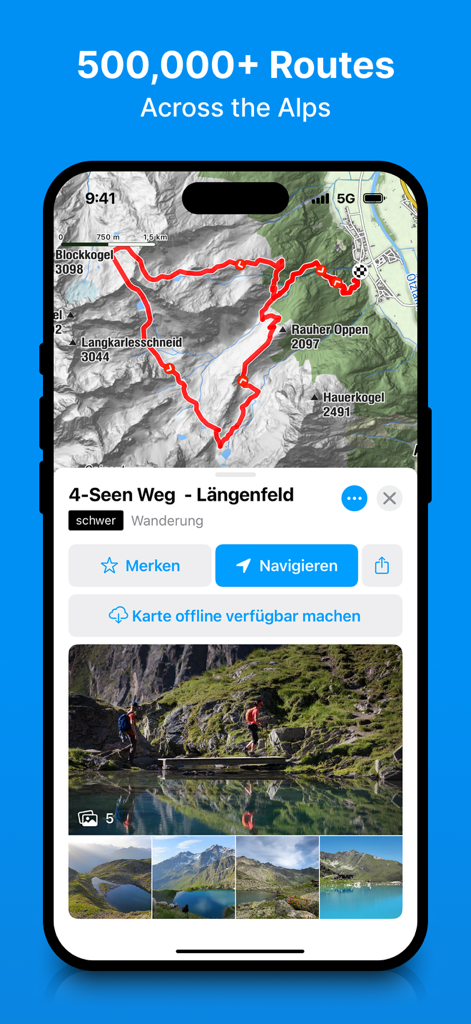
bergfexアプリで詳細なハイキングルートと地形図を表示するスマートフォンの画面
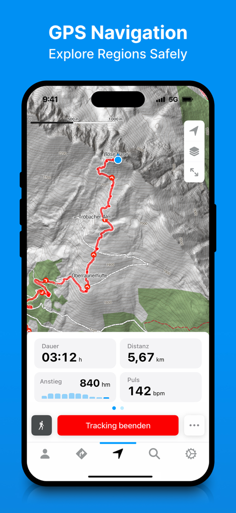
topographic map with a hiking route and real time tracking statistics displayed by the bergfex app
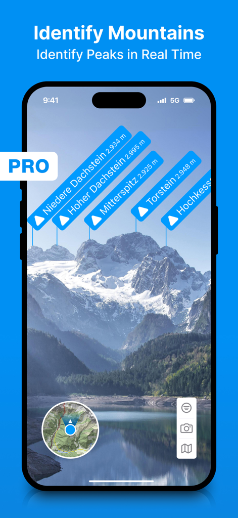
Augmented reality labels using to identify mountain peaks in real time shown by the bergfex app smart phone screen
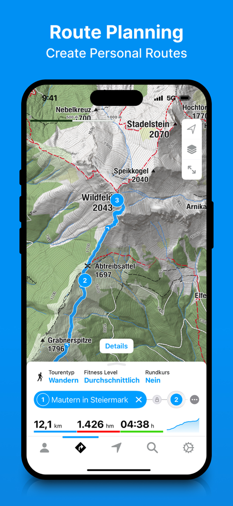
Bergfex app interface showing route planning on a detailed topographic mountain map with hiking stats
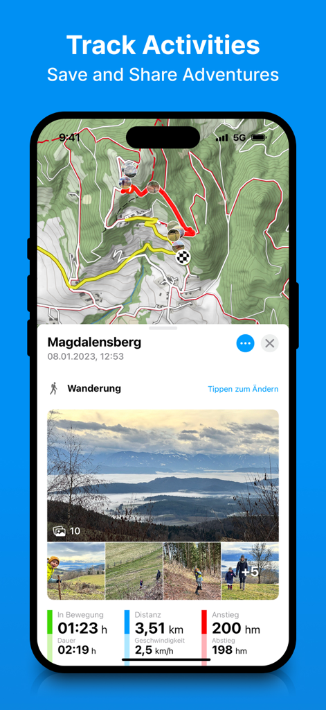
Bergfex app showing a tracked hiking route on a topographic map with integrated photos and performance statistics.
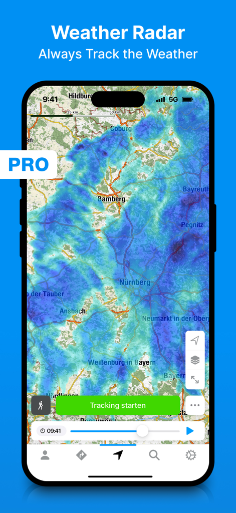
Bergfex hiking app weather radar interface with rain tracking overlay
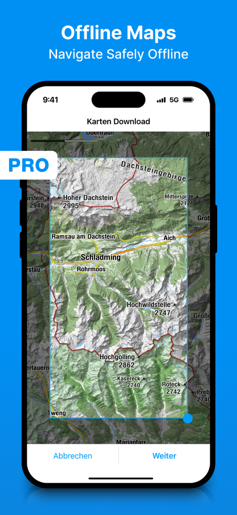
bergfex appでオフライン地形図をダウンロードするための選択画面
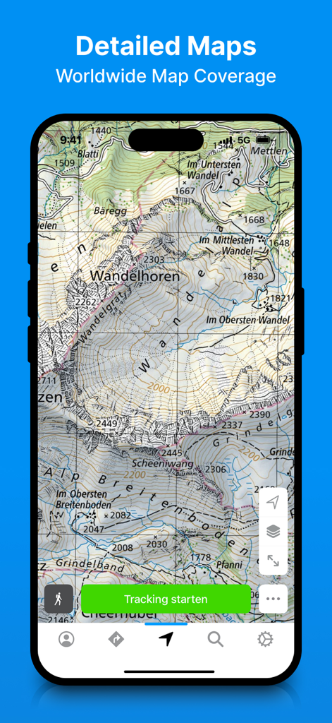
bergfexハイキング&トラッキングアプリでの詳細な地形図表示
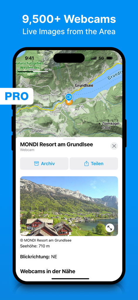
Outdoor trip planning for a topographic map interface and live webcam images shown in the bergfex hiking app screenshot.
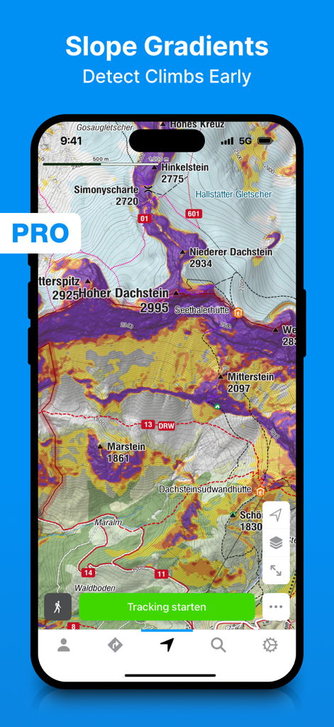
Hikers and skiers for a topographic map shown slope gradient overlays in the bergfex app
説明
Download
類似アプリ
似た機能とユーザー体験を持つアプリ

AllTrails: Hike, Bike & Run
AllTrails, Inc.

Pedometer++
Cross Forward Consulting, LLC

Organic Maps: Offline Map
Organic Maps OU

Gaia GPS: Mobile Trail Maps
Trailbehind, INC.

Offline hiking maps: Mapy.com
Seznam.cz a.s.

Hiking Map Poland
Mapa Turystyczna sp. z o.o.

MapOut
Valnova GmbH

FarOut: Offline GPS Trail Maps
Atlas Guides DE, Inc.

Norgeskart
Norgeskart AS
このページはアプリまたはその開発者の公式ページではなく、情報提供および論評を目的として作成された独立した編集出版物です。明示的に別段の記載がない限り、アプリおよびその開発者は、MWM、Apple、Google Play、アプリのパブリッシャー、またはアプリの開発者と提携、承認、後援、認可、またはその他の公式的な関係はなく、このページのいかなる内容も、アプリがMWMのサービスを使用して開発されたことを意味するものではありません。すべての商標、ロゴ、スクリーンショット、その他のコンテンツはそれぞれの所有者の財産です。