このページはアプリまたはその開発者の公式ページではなく、情報提供および論評を目的として作成された独立した編集出版物です。明示的に別段の記載がない限り、アプリおよびその開発者は、MWM、Apple、Google Play、アプリのパブリッシャー、またはアプリの開発者と提携、承認、後援、認可、またはその他の公式的な関係はなく、このページのいかなる内容も、アプリがMWMのサービスを使用して開発されたことを意味するものではありません。すべての商標、ロゴ、スクリーンショット、その他のコンテンツはそれぞれの所有者の財産です。

Maps 3D PRO - Hike & Bike
170万人の冒険者が利用するオフラインNASAグレード地形マップとプロフェッショナルGPSトラッキングで、すべてのピークとトレイルを制覇しましょう。
ダウンロード
378K+ユーザー評価
評価数
100開発元
カテゴリ
Navigation対応言語
6最新バージョン
6.8サイズ
25.2 MBリリース日
2011年3月25日あらゆる地形を素晴らしい3Dでマスター
フラットマップでのナビゲーションはやめましょう。本格的な探検家のために設計されたプログレードの3D標高とオフラインGPSトラッキングで、次の冒険を鳥瞰図で把握しましょう。
高精度3Dビジュアライゼーション
NASAの地形スキャンを使用して、谷、丘、ピークを視覚化します。ルートを開始する前に、正確な標高と難易度を確認できます。
完全オフライン信頼性
出発前に世界中のマップデータをダウンロードします。完全なGPS機能とゼロセル信号で、最も奥深いバックカントリーでも安全にナビゲートします。
以下のスクリーンショットと説明は、アプリの公式ストアリスティングから直接取得されたものであり、アプリ開発者の所有物です。
アプリストア
スクリーンショット
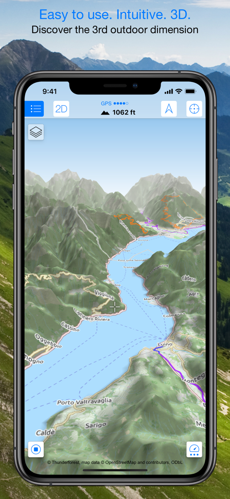
山とハイキングトレイルのある3D地形図を表示するスマートフォン。
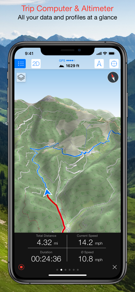
速度、距離、高度を含むトリップコンピュータデータを示す3D地形図を表示するMaps 3D PROインターフェース
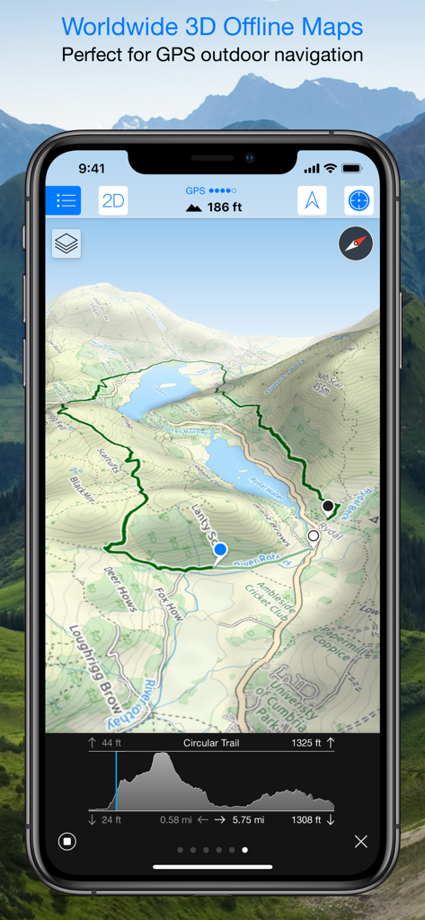
ハイキングトレイルと標高プロファイルを持つ3D地形図を表示するMaps 3D PROアプリインターフェース
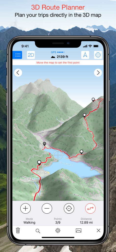
3D地形図上に計画されたハイキングルートを示すMaps 3D PROアプリのスクリーンショット
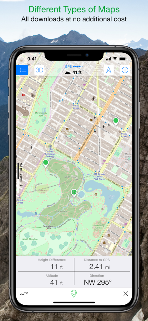
リアルタイムの高度と距離追跡データを含む詳細な公園マップを表示するMaps 3D PROアプリインターフェース
説明
Download
類似アプリ
似た機能とユーザー体験を持つアプリ

AllTrails: Hike, Bike & Run
AllTrails, Inc.

Pedometer++
Cross Forward Consulting, LLC

Organic Maps: Offline Map
Organic Maps OU

Gaia GPS: Mobile Trail Maps
Trailbehind, INC.

Offline hiking maps: Mapy.com
Seznam.cz a.s.

Hiking Map Poland
Mapa Turystyczna sp. z o.o.

MapOut
Valnova GmbH

FarOut: Offline GPS Trail Maps
Atlas Guides DE, Inc.

Norgeskart
Norgeskart AS
このページはアプリまたはその開発者の公式ページではなく、情報提供および論評を目的として作成された独立した編集出版物です。明示的に別段の記載がない限り、アプリおよびその開発者は、MWM、Apple、Google Play、アプリのパブリッシャー、またはアプリの開発者と提携、承認、後援、認可、またはその他の公式的な関係はなく、このページのいかなる内容も、アプリがMWMのサービスを使用して開発されたことを意味するものではありません。すべての商標、ロゴ、スクリーンショット、その他のコンテンツはそれぞれの所有者の財産です。