このページはアプリまたはその開発者の公式ページではなく、情報提供および論評を目的として作成された独立した編集出版物です。明示的に別段の記載がない限り、アプリおよびその開発者は、MWM、Apple、Google Play、アプリのパブリッシャー、またはアプリの開発者と提携、承認、後援、認可、またはその他の公式的な関係はなく、このページのいかなる内容も、アプリがMWMのサービスを使用して開発されたことを意味するものではありません。すべての商標、ロゴ、スクリーンショット、その他のコンテンツはそれぞれの所有者の財産です。

onX Backcountry: Trail GPS App
このアプリは、未開の地で地図を読み解き、自然の脅威を事前に察知する「野生の勘」をデジタルで手に入れることを可能にする。あなたの冒険は、もはや地形や通信状況に左右されない。
ダウンロード
1M+ユーザー評価
評価数
5.7K開発元
カテゴリ
Navigation対応言語
1最新バージョン
26.13.0サイズ
433.2 MBリリース日
2020年12月9日テックアナリストによるオフラインナビゲーションアプリの包括的評価
「onX Backcountry: Trail GPS App」の主要機能分析
オフライン3DマップとGPS追跡
本アプリは、携帯電話の電波が届かない遠隔地においても、ユーザーが詳細な3D地形図にアクセスし、正確なGPS追跡機能を利用して現在地を把握することを可能にします。これにより、山中で信頼性の高いナビゲーションと安全なルート確認が保証されます。
広範なオフラインルートデータベース
このアプリは、ハイキング、マウンテンバイク、ロッククライミング、バックカントリースキーにわたる65万マイル以上のトレイル、30万以上のクライミングルート、4千以上のスキーコースという広範なデータベースを提供します。ユーザーはこれらのデータをオフライン環境でも利用でき、計画と発見をサポートします。
危険情報マップレイヤー
本ツールは、山火事、雪崩地形、積雪状況などの潜在的な危険情報を表示するマップレイヤーを備えています。ユーザーはこれらの情報を用いて、活動計画におけるリスクを事前に評価し、安全なルート選択を行うことが可能です。
詳細な地形分析ツール
ユーザーは、LiDARベースの地形図や、地形の傾斜角および向き(Slope Angle, Slope Aspect)といった詳細な地形分析ツールを利用できます。これは特にバックカントリースキーやロッククライミングにおいて、ルートの選択と安全性の評価に不可欠な情報を提供します。
カスタムルート作成とウェイポイント
このアプリは、ユーザーが既存のトレイルに沿って容易にルートを作成できる「スナップ・トゥ・トレイル」機能や、興味のある地点にカスタムウェイポイントを追加する機能を提供します。これにより、ユーザーは自身の特定のニーズに合わせた柔軟な計画とカスタマイズが可能です。
リアルタイム気象と衛星画像
本ツールは、局地的な天気予報、時間ごとの風速予測、および過去2週間以内の最新の衛星画像を提供します。ユーザーはこれらの情報を用いて、活動計画を立てる上で重要な気象条件と地表の状態を詳細に把握し、適切な判断を下すことができます。
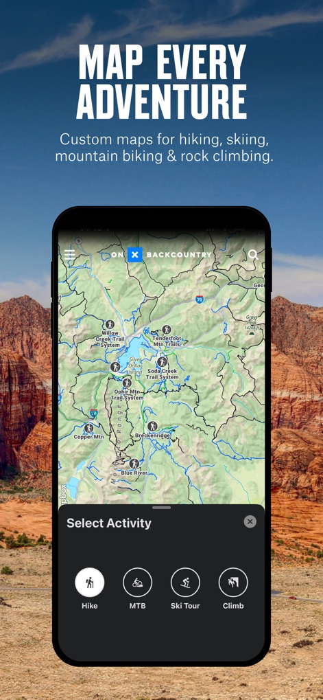
活動別マップモード
ユーザーは、ハイキング、マウンテンバイク、バックカントリースキーなど、自身の特定の活動に合わせて最適化されたマップモードを選択できます。これにより、各アクティビティに関連する情報が優先的に表示され、計画とナビゲーションがより効率的になります。
公有地および私有地の情報
このアプリは、米国全土における公有地の境界線情報を表示し、エリートプランのユーザー向けには私有地の詳細な所有権データを提供します。これにより、ユーザーは土地利用の規則を遵守し、責任あるアウトドア活動を行うことが可能です。
よくある質問
について知っておくべきこと onX Backcountry: Trail GPS App
What is onX Backcountry used for?
onX Backcountry is a GPS map app for outdoor recreation, enabling users to discover and navigate new trails for hiking, skiing, mountain biking, and climbing, even offline.
Does onX Backcountry offer offline navigation?
Yes, onX Backcountry allows users to download 3D maps with interactive trail data for offline use. This turns a phone into a handheld GPS device without cell service.
Can I create custom routes in onX Backcountry?
Yes, onX Backcountry allows users to map custom routes seamlessly with its snap-to-trail feature. Users can also set Waypoints and review detailed slope data for planning.
What types of maps does onX Backcountry provide?
onX Backcountry provides 3D maps, HD topographic maps, satellite imagery, and hybrid views. Users can also select map modes specific to hiking, MTB, climbing, or ski touring.
What safety features are included in onX Backcountry?
onX Backcountry includes safety tools like localized weather forecasts, hourly wind data, and Trail Reports. It also features map layers to monitor wildfire, air quality, and avalanche terrain exposure.
Is there a free trial for onX Backcountry?
Yes, onX Backcountry offers a free seven-day Premium trial upon app installation. This trial provides access to all the app's advanced features for a complete backcountry experience.
What are the exclusive features for onX Backcountry Elite members?
onX Backcountry Elite membership exclusively includes the Private Land Layer, which shows property maps and boundaries, and Recent Imagery, providing detailed satellite views from the past two weeks.
Can onX Backcountry track my outdoor activity statistics?
Yes, onX Backcountry allows users to track their location and measure activity stats. It displays key trip details such as distance, elevation gain, and elevation loss in seconds.
Where can I find the privacy policy for onX Backcountry?
The official privacy policy for onX Backcountry is available on the onXmaps website. You can find the detailed policy at https://www.onxmaps.com/privacy-policy.
Does onX Backcountry provide detailed trail information?
Yes, onX Backcountry offers a "Guidebook Experience" with detailed trail descriptions. This includes trail lengths, difficulty levels, elevation profiles, and user reviews for various routes.
以下のスクリーンショットと説明は、アプリの公式ストアリスティングから直接取得されたものであり、アプリ開発者の所有物です。
アプリストア
スクリーンショット
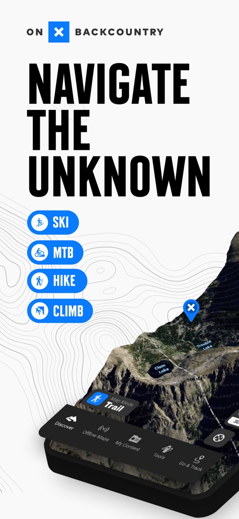
本アプリは、ハイキングやスキー、登山といった多様なアクティビティモードと、詳細な地形図でユーザーを未知の冒険へと導きます。
未知をナビゲート
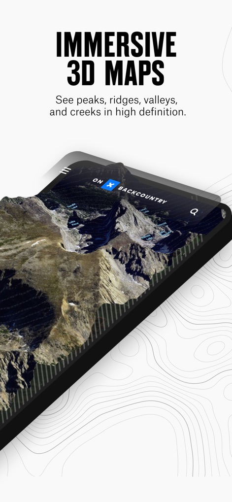
ユーザーは高精細な3Dマップで、山々のピークや谷、小川などの地形を細部まで視覚的に把握できます。
没入型3Dマップ
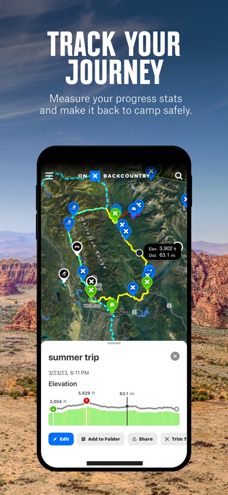
このツールはGPSトラッキング機能により、ユーザーの移動ルートと、詳細な標高や距離といった旅の統計情報を記録します。
冒険を追跡
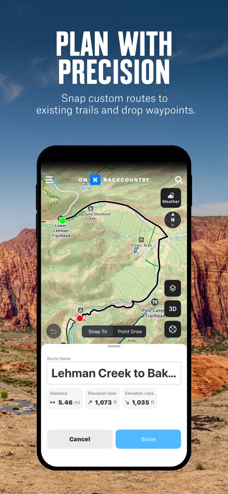
ユーザーはスナップ・トゥ・トレイル機能で簡単にルートを作成し、詳細な距離や獲得標高・損失標高を確認して計画を立てられます。
精密なルート計画
本アプリは、ハイキングやMTB、スキーツアーなどアクティビティごとに特化したマップモードを提供し、広範囲にわたるトレイルネットワークを明確に表示します。
あらゆる冒険を地図に
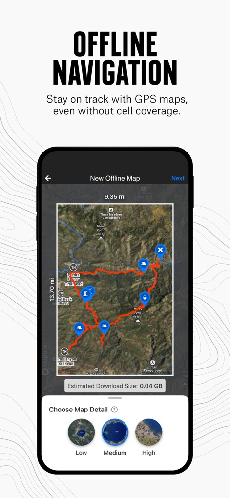
ユーザーは、オフラインマップをダウンロードすることで、電波が届かない場所でも詳細な地図と、選択可能な解像度でナビゲートできます。
オフラインでナビゲーション
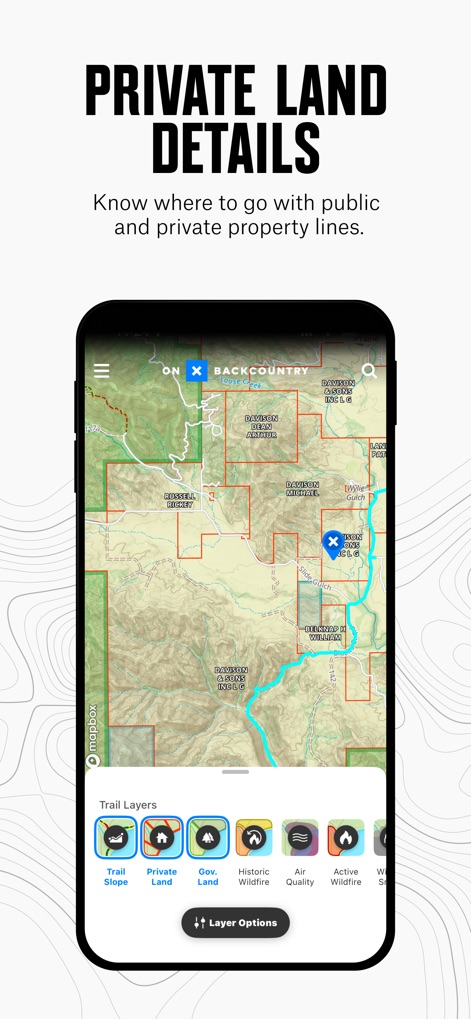
この機能は、私有地や公有地などの地権情報をマップレイヤーとして表示し、ユーザーが安全なルート選択を行えるよう支援します。
私有地の詳細情報
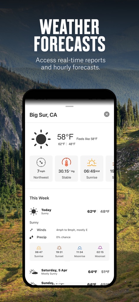
本ツールは、リアルタイムの気象情報と、時間ごとの風速予報を提供し、ユーザーの安全なアウトドア活動をサポートします。
詳細な天気予報
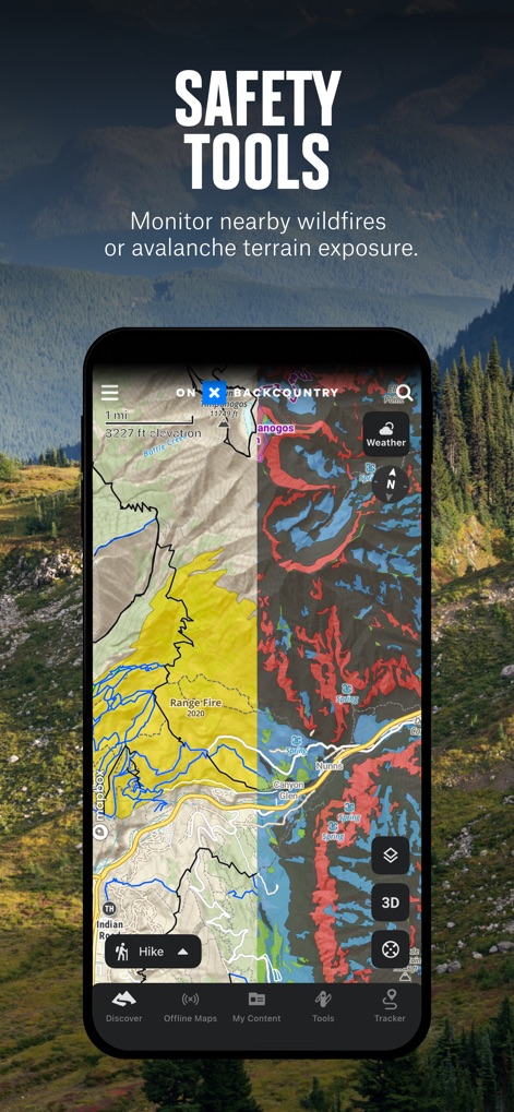
ユーザーは雪崩地形や森林火災の活動状況を示すレイヤーを利用し、潜在的な危険地域を事前に特定して安全な計画を立てることができます。
安全のためのツール

このアプリは、専門家によって推奨されたルート情報を提供し、距離や獲得標高、難易度といった詳細な統計を通じてユーザーのトレイル探索を充実させます。
ガイドブック体験
説明
Download
類似アプリ
似た機能とユーザー体験を持つアプリ

AllTrails: Hike, Bike & Run
AllTrails, Inc.

Pedometer++
Cross Forward Consulting, LLC

Organic Maps: Offline Map
Organic Maps OU

Gaia GPS: Mobile Trail Maps
Trailbehind, INC.

Offline hiking maps: Mapy.com
Seznam.cz a.s.

Hiking Map Poland
Mapa Turystyczna sp. z o.o.

MapOut
Valnova GmbH

FarOut: Offline GPS Trail Maps
Atlas Guides DE, Inc.

Norgeskart
Norgeskart AS
このページはアプリまたはその開発者の公式ページではなく、情報提供および論評を目的として作成された独立した編集出版物です。明示的に別段の記載がない限り、アプリおよびその開発者は、MWM、Apple、Google Play、アプリのパブリッシャー、またはアプリの開発者と提携、承認、後援、認可、またはその他の公式的な関係はなく、このページのいかなる内容も、アプリがMWMのサービスを使用して開発されたことを意味するものではありません。すべての商標、ロゴ、スクリーンショット、その他のコンテンツはそれぞれの所有者の財産です。